ADVENTURE HIKES AND CANYONEERING
IN THE SOUTHWEST
© Christopher Earls Brennen

|
|---|

|
Hike E3. Toroweap/Lava Falls
- Hiking time: 7 hours
- Estimated hiking distance: 3 miles
- Elevation gain: 2540 feet
- USGS Topo Maps: Vulcan's Throne
- Difficulties: A steep, rugged and mostly trailess route needing careful navigation; the heat is a serious difficulty on the return climb
- Special equipment: Protection from the sun, extra water and leather gloves
-
ACA Rating: 2A III

Characteristics
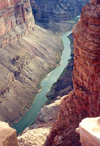
The most spectacular viewpoint in the Grand Canyon is the remote and rarely visited outpost on the North Rim known as Tuweep or Toroweap. Here, from a dramatic shelf you can look straight down about 2500ft directly to the Colorado River. River rafters often choose to overnight at one of the beaches directly below the Toroweap viewpoint. But, at this elevation, you can only just see the rafts and the people are but dots. It is a truly awesome place, this overlook. What makes it even more special is that only a few people each day come to enjoy this magnificent view. So you may be alone at the edge as I was. The price for avoiding the crowds at either of the other Grand Canyon sites, the North Rim or the South Rim, is that you must drive 60mi over a dirt road to get here. But it is worth every mile of it.
The hike down to the Colorado proceeds along what is known as the Lava
Falls Route. It begins at a trailhead a mile or so west
of the viewpoint.
John Annerino in his classic guide "Hiking the Grand Canyon" describes
this non-trail as
".. an avalanche of a route waiting to throw you to your knees
during the descent and to suck the last drop of moisture out of you
during the debilitating crawl out. There is little more to say about
the viper-plagued route snaking its way through the
glass-black lava other than to follow the rock cairns ...."
It is indeed a steep and rugged descent of 2540ft requiring
careful route finding though there are cairns marking most of the way.
In several places some modest climbing is required; for this and other
protection against the sharp and sun-scorched lava rock a pair of leather
gloves is highly recommended. Special care is needed for
the rock is quite unstable in places and thus falls are common. In addition,
it is advisable to get a very early morning start so that you can begin
the return climb before it gets too hot. In the summer, the sun bakes
this mostly shadeless south-facing slope and can make the ascent a
grim experience. In the year 2000, 12 people had to be helicoptered
off this route, mostly because of heat prostration.
Thus the hike requires some careful planning and preparation in order to avoid an unpleasant experience. The best time of year is April or May, after the rim temperatures have risen but before the midday temperatures on the lava field become too extreme. I also recommend that you obtain a copy of the typed sheet prepared by the Ranger describing in detail the Lava Falls Route and the important markers along the way. Stop at the Ranger Station to obtain this; otherwise there should be copies in the register box at the trailhead. Finally it is essential to carry lots of water and/or sports drink; I used four quarts for drinking and another couple of quarts for wetting down my head and body. In the heat I find that a broad-brimmed hat and a small, wet towel around my neck provide great relief.
Trailhead
There are several dirt roads that will access the Toroweap area from the asphalt roads (I15 or US389) to the north. The best choice is the Sunshine Route (BLM road #109) that leaves US389 about 7mi west of Fredonia, Arizona. The turn-off to the south is signposted Toroweap and most of the 61mi is well-graded dirt road that is relatively easy driving under dry conditions. When wet it may be much more difficult or impassable. Approximately 48mi from the highway, the road to Mt. Trumbull forks off to the right and beyond this the route has more washboarding. As you approach the Tuweep Ranger Station 55mi from the highway it becomes rougher still. Continuing on, note the turn-off to the right 3.5mi beyond the Ranger Station that is signposted Lava Falls Route. This is the road to the trailhead that you will take later. However, first you should continue another 2.8mi to the Toroweap Overlook itself, passing the left turn-off to the campground on the way. The last mile or so over the slickrock is the roughest part of the trip. You should allow 2hr to get from the highway to the overlook.
The best strategy for this adventure is to camp overnight at the scenic campground (8 sites) just a few hundred yards back from the Toroweap overlook. This allows for an early start the next morning, the earlier the better in order to minmize the heat on the return climb out of the canyon. To access the trailhead drive 2mi back north along the road to the left turn onto the rough spur road, signposted the Lava Falls Route and known as Vulcan's Throne Route. This proceeds about 2.4mi around the north side of the hill known as Vulcan's Throne (summit 5102ft) to the Lava Falls Route trailhead at the edge of the rim. This spur road is rough in places and passes over the shallow and potentially muddy Toroweap Lake that normally dries up in the summer making vehicle passage possible. However, even dry it would be difficult in a 2WD vehicle. The trailhead parking area (36o12.70'N 113o5.02'W and elevation 4180ft) is just a few yards from the rim.
Hike
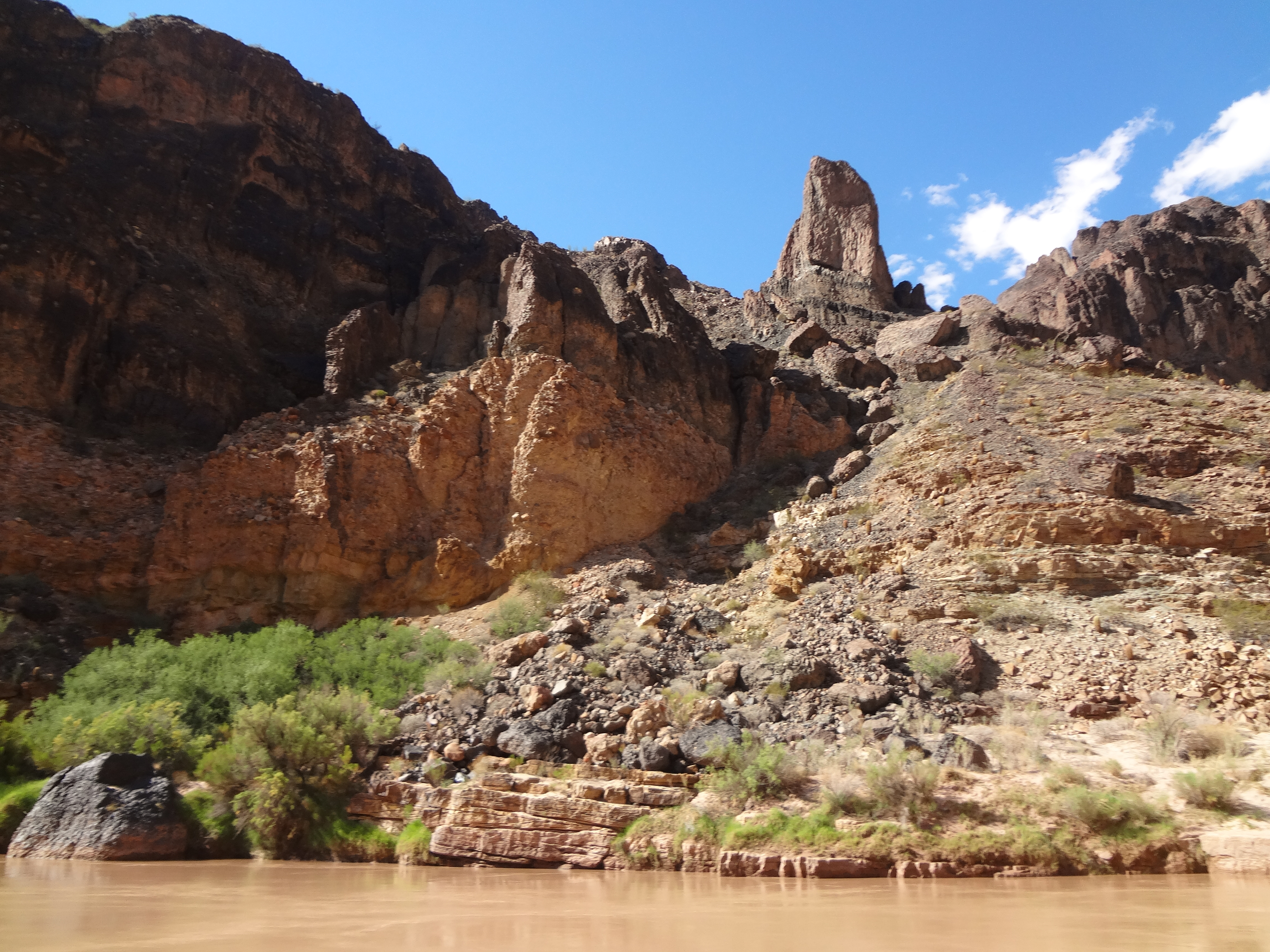
Be sure to stop, sign in at the trailhead register (36o12.70'N 113o5.02'W) and consult the route description mentioned above. The trail proceeds down a shallow gully that almost immediately drops off precipitiously. The use-trail contours right and then drops down a steep ridge to the bottom of this gully called Vulture Valley because of the number of turkey vultures that like to cruise the skies overhead. During this descent note the bright red cinder slope off to the left ahead of you that makes up the east side of Vulture Valley. This contrasts with the black lava elsewhere and will serve as a useful trail marker on your return. In the bottom of Vulture Valley there is a small level area that terminates in another, broader drop-off (called a pour-off in the guide and Lava Falls in Annerino's book). There are only a few places where you can climb down this vertical step. Unfortunately, this is where the cairned trail is hardest to follow so look carefully for the ducks. Once you have started the descent of the pouroff via a steep gully look for cairns leading along shelves headed east for a short distance. Hopefully, after a steep descent, this will allow you to access a well-ducked and better established use-trail that leads straight down a steep and rough lava slope that begins at the base of the pour-off and heads for a prominent ridge of red cinders that can be seen about 1000ft below you. That ridge is called Finger Rock Ridge because of the obvious protruding rocks. While still high on the pour-off it is important to identify the red cinders and protruding rocks of Finger Rock Ridge. You may also be able to discern a smooth flat area on the ridge with a beaten path. Even if you fail to access the worn use-trail down the lava field you should head directly down toward Finger Rock Ridge (36o12.25'N 113o4.83'W), reaching this objective about 1hr 20min after starting out. It is a good place to rest when coming or going; it is also a good place to cache water for the climb back up. Take time here to enjoy the partial view of the Colorado still far below you. The large valley you look directly into on the opposite side of the canyon is Prospect Valley and a route through this valley seems to take you up to the rim though no trail can be seen. Like the land on the south rim above it, Prospect Valley is in the Hualapai Indian Reservation. Above the rim, several short stretches of dirt road can be seen.
| 
| |
|---|---|---|
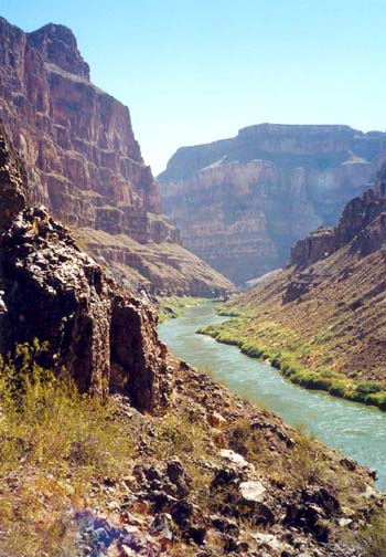
| View from Toroweap Overlook | From midway down looking upstream, | |
| Toroweap Overlook high on the left |
Resuming your descent, a well-worn and well-ducked trail goes to the left of the red cinder ridge-top, crosses the beaten trail on the flat red cinder area seen from above, and arrives at a small platform with a number of cairns and makeshift seats. The route then drops again to the left before contouring down and across to a narrow saddle, Black Lava Saddle. This is very important to identify since the last, steep 1000ft drop to the river begins here and there may only be this one viable route down. It is also an alternate place to cache water. You should reach Black Lava Saddle about 1hr 30min after leaving the trailhead.
A steep ravine known as The Chute drops down from Black Lava Saddle to the river. The well-ducked trail descends a slope in the middle of The Chute avoiding an even more precipitous gully just off to the left. After several hundred feet the trail contours further right and then back left again to access the deep gully on the left bounded by a steep cliff on its east side. The descent proceeds down the steep loose scree in the gully bottom for several hundred feet and then contours to the right and out of the gully bottom, accessing and descending a smaller gully all the way to the banks of the Colorado (36o11.99'N 113o4.68'W and elevation 1640ft). You arrive at the river where there is a small shelf at the water's edge and several huge lava boulders just upstream. Make careful mental note of the boulders so that you will have no difficulty identifying the right gully when it comes time to start back. The total time for the descent should be about 2hr 15min.
| 
| |
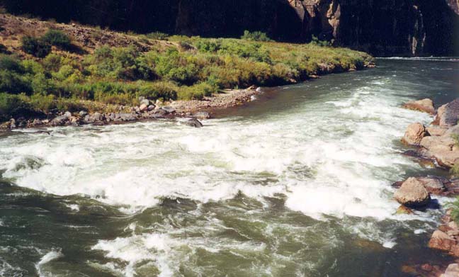
|---|---|---|
| Descent chute from below | Lava Falls Rapids from upstream |
Unlike the Phantom Ranch area 120mi upstream, the temperature of the Colorado is quite pleasant and invites immersion. However, the bed of the river drops off steeply so it is not as easy to immerse yourself as you might have wished during the descent. There are better beaches a short way downstream and you will want to head in this direction anyway in order to view the spectacular Lava Falls Rapids, about 400yds downstream. It is relatively easy to make your way along the shoreline, climbing over or around the few large boulders that lie in the way. There is also a use-trail higher up that avoids the boulders. It should not take more than about 15min to get to Lava Falls Rapids (36o11.88'N 113o5.00'W). Along the way, some of the rafts that travel down the Colorado through the Grand Canyon may pass you by. Close to the Falls there is an excellent vantage point on top of a large boulder from which to view their descent of Lava Falls Rapids. The smaller rafts seem to land at a beach so that the pilots can inspect the rapids before running them. This human traffic has created a well-worn trail along this short section of the shoreline.
The Lava Falls Rapids themselves are quite spectacular and hurl even the largest rafts around like they were matchboxes. It is said that these are among the steepest and most difficult rapids in all of the Grand Canyon. The spectacle is well worth the effort to get here. I listened as raft pilots discussed the route they might be able to take in their smaller craft. Apparently on this day the left side was unrunnable and they would have to plot their course down the right side quite carefully.
It is hard to drag yourself away from the river and the shade along
the shore but it is important to begin the return hike before
the sun gets too high and hot. The first leg of the ascent up to
Black Lava Saddle can be done in the shade of the east wall
of The Chute provided you leave while it is still early in the morning.
But above Black Lava Saddle there is little or no shade for over
1000ft and this is where you will be glad of all the water you brought
and of any other protection against the heat. The lava field seems particularly
endless and I was so relieved to reach the pouroff that I temporarily
lost my way. The red cinder wall in Vulture Valley allowed me
to regain the correct route and reach the trailhead. On a day in
late June it took me 4.5hr to complete the climb back
to the rim. In cooler weather it probably could be accomplished
quite a bit faster.
Last updated 7/1/01.
Christopher E. Brennen