ADVENTURE HIKES AND CANYONEERING
IN THE SOUTHWEST
© Christopher Earls Brennen

|
|---|

|
Hike H4. Tenaya Canyon
- Hiking time: 10 hours
- Estimated hiking distance: 10 miles
- Elevation gain: Small
- USGS Topo Maps: Tenaya Lake, Yosemite Falls, Half Dome
- Difficulties: Descent of steep rock slab, four rappels up to 70ft, much bouldering and downclimbing, one pool swim
- Special equipment: 160ft rope, rappelling equipment, harnesses, 30ft webbing, leather gloves, dry bag, quick-drying clothing
-
ACA Rating: 3B IV

- Special Note: Careful route-finding is essential to a successful and safe descent of this canyon. A number of fatalities have occurred due to deviating from the recommended route. It is specially important to identify and access the Lone Boulder and to follow the descent from there.
Characteristics
The great glacier that carved out the spectacular monuments of Yosemite National Park began up in the high country east of the valley near the beautiful swaths of Tuolumne Meadows. Nowadays the tourist can only see a part of the glory which that process created for the road stops where the flat valley floor ends near Mirror Lake in the shadow of Half Dome. A short distance beyond that point travel along the bottom of the gorge becomes very difficult due to the ruggedness of the terrain. So difficult, in fact, that the trails terminate just a mile or so upstream of Mirror Lake and there are signs warning that travel beyond that point is dangerous. But nature's glory does not stop there. Between the valley and Tenaya Lake some 10 miles upstream is a magnificent canyon with enormous rock faces and spectacular scenery. This adventure hike down Tenaya Canyon traverses this rugged wilderness to explore the part of Yosemite Valley the tourists never see.
Tenaya Lake, Creek and Canyon take their name from the shrewd old chief of a band of native Americans who called themselves the Ahwahneechees and were living in Yosemite Valley (which they called Ahwahnee) when the white men first arrived. Numbering about 200 the Ahwahneechees had already been ravaged by the white man's diseases that had preceded him. Sometimes the younger men would travel west toward the lowlands to poach from the white settlements and ranches there. But generally they lived peaceably on a diet of acorns, roots and game.
In the early 1850s, the white settlers decided to remove the Ahwahneechees to a reservation near Fresno and sent a battalion of men to effect this deportation. Needless to say the Ahwahneechees did not want to leave their valley. There followed a number of evasions and negotiations and escapes. Months passed and when a second battalion under a Captain John Boling entered the valley to resume the deportation effort, the confrontation turned violent. Several young Indians were captured and one was shot while trying to escape. This young man was one of Chief Tenaya's favorite sons. When the old chief was informed, he was enraged and during a confrontation with Captain Boling expressed that anger in laying a curse on the white man:
''Kill me, sir captain! Yes kill me, as you killed my son; as you would kill my people if they were to come to you! You would kill all my race if you had the power. You have made me sorrowful, my life dark; you killed the child of my heart, why not kill the father? You may kill me sir captain, but you shall not live in peace, I will follow in your footsteps, I will not leave my home but be with the spirits among the rocks, the waterfalls, in the rivers and in the wind; wheresoever you go I will be with you. You will not see me, but you will fear the spirit of the old chief, and grow cold.'' (from Elizabeth Godfrey's ``Yosemite Indians''.)
To this day, Yosemite Valley and Tenaya Canyon are haunted by the spirits of the murdered boy. Indians and white men alike tell tales of mysterious accidents and unaccountable deaths that they attribute to the curse of Chief Tenaya.
In summary, Tenaya Canyon got off to a bad start in recorded history. And the curse seemed confirmed during John Muir's exploration of the canyon, described in chapter 2 of ``Steep Trails'' (1918). Setting out to venture up into Tenaya Canyon from the valley, this intrepid mountain goat of a man fell for ``the first time since I touched foot to Sierra rocks''. He describes how he was knocked unconcious and only saved from a life-threatening continuation of the fall by being wedged among short, stiff bushes. Recovering from his fall, Muir spent the next few days ascending the Inner Gorge, eventually ``.. escap(ing) from the gorge about noon, after accomplishing some of the most delicate feats of mountaineering I ever attempted...''. The canyon's reputation continues today for every year exuberant visitors anxious to see what lies beyond the end of the trail, venture into Tenaya Canyon unprepared and have to be rescued by the Park Service. The standard guide map is marked in red ``Hiking in Tenaya Canyon is dangerous and strongly discouraged''. Park rangers refer to it as the ``Bermuda Triangle of Yosemite''.
But to the experienced canyoneer with good guidance (for there are several places where careful navigation is essential), Tenaya Canyon provides a rugged and spectacular adventure. It is best undertaken in late summer when the water is running low. We were fortunate to be accompanied by Bob Courtemanche. This was the 21st year Bob had travelled down Tenaya Canyon and his guidance made the trip particularly enjoyable.
Trailhead
This hike requires a very long car shuttle that should be set up the day preceding the hike. Drive two vehicles to Yosemite Valley and leave one in the backpackers parking lot (37o44.17'N 119o34.01'W) that is about 1/4 mile east of Curry Village on the road to Happy Isles. This lot has bear boxes for food and I recommend storing any food there. Then start the long drive out of the valley and up to and along the Tioga Road. The hike begins at the Sunrise trailhead (37o49.55'N 119o28.22'W and elevation 8160ft) on the Tioga Road at the south end of Tenaya Lake. There are bear boxes here too to store food you may not wish to leave in your vehicle.
Hike
Follow the Sunrise trail that immediately crosses Tenaya Creek streambed though this has almost no water in the late summer when you should be embarking on this adventure. Though you can start down the creek bed from here, it is somewhat more convenient to continue on the Sunrise trail to where it starts to climb a little through rocky terrain. There, 15min and 0.5mi from the start, you should leave the trail and follow the streambed, gradually crossing to the right or west side where the going becomes relatively easy over flat rock slabs interspersed with low forest. Above you on the right is a steep rocky ridge that now separates you from the Tioga Road (this ridge also prevents you from viewing the creek from the Tioga Road). About 40min from the trailhead, the canyon begins to deepen and you follow the streambed boulders past an old Park Service sign on the right (37o48.64'N 119o28.24'W) that reads:
WARNING
This is not a trail
Travel beyond this
point is dangerous
without climbing
equipment. Return
to Tioga Road.
A short distance beyond the sign, you arrive at a crest (elevation 8050ft) where the stream (if it is running) drops into a huge rock-lined bowl where it joins another coming from the left and then veers to the right. This bowl is an awesome, majestic sight with nothing for hundreds of yards but the glacier-polished rock edged with partly forested heights all around. This is where the big-time glacier began. To negotiate the rock bowl it is best to contour to the left, traversing along more gently sloping rock into the bottom of the huge expanse. Once you reach the stream you can then proceed down the rock-lined valley toward the west. Soon, at an elevation of about 7850ft, Half Dome comes into view to the west and, about 1.5hr from the start, you encounter a flatter, forested valley bottom. It is simplest to stay to the right of the forest where the going on the rock slabs is easier. While covering this section, it is very important to identify a large, single, prominent boulder called the``Lone Boulder'' (37o47.15'N 119o29.17'W) that is up on the profile of the bare rock shoulder on the left side. Half Dome appears in the distance behind this boulder. When the forest peters out and the going becomes rougher move closer to the streambed. The Lone Boulder temporarily disappears from view so if you have a mental picture of its location it will be very valuable and important. Following the stream you come, at 7500ft, to a lovely little pool where you can swim if you wish but also filter water for the exertions ahead. You will now have travelled about 3.3mi from the trailhead in about 1hr 45min.
 | 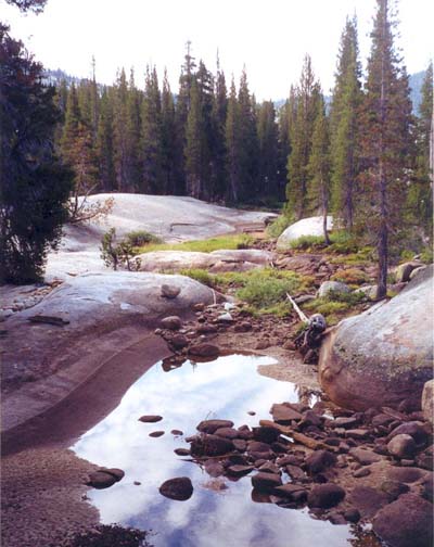
| |
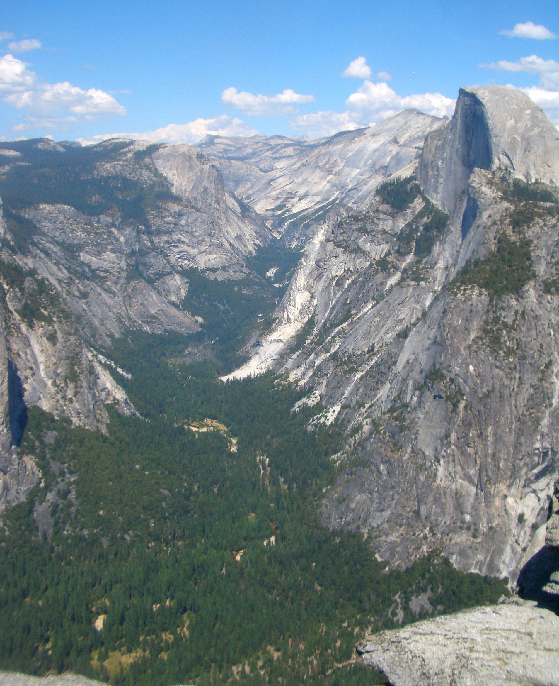
|---|---|---|
| Tenaya Canyon from Glacier Point | Tenaya Creek just after start |
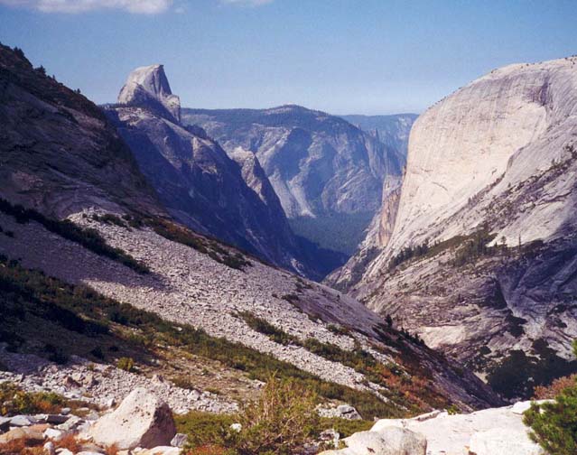
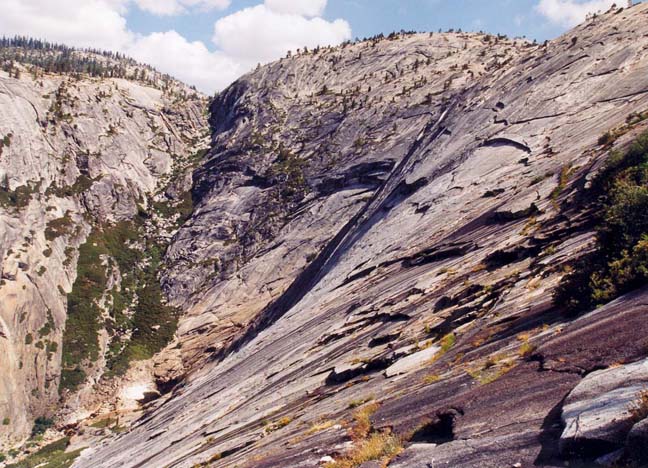
If not before this, you will become aware of a huge abyss ahead between you and the massive, sheer face of Mount Watkins to the north. Tenaya Creek proceeds northwest from here and drops about 1000ft over polished rock down into the deep valley ahead. This 1000ft stream descent is known as the Pywiack Cascades. Following the present safer and easier route you will not encounter the Pywiack Cascades. While other, highly experienced rock climbers have rappelled down the cascades, it is strongly recommended that you follow the present recommended route. From the pool mentioned above, start climbing the rock slope to the west in order to access the Lone Boulder. Soon this will come into view and you should head directly for it. Once you reach the ridge on which the Lone Boulder sits, you are treated to a spectacular view to the north and west. Tenaya Creek now lies a thousand feet below you at the bottom of a steep polished-rock slope. To the west the magnificent Yosemite Valley and its gigantic monuments, Half Dome, Glacier Point and the rest. The route of descent into the valley below lies to the southwest, down to the left of the slope directly below you. Here it is really important to follow the recommended route. To stray too far to either side is to risk finding yourself on a steep polished rock slope with many hundreds of feet of exposure.
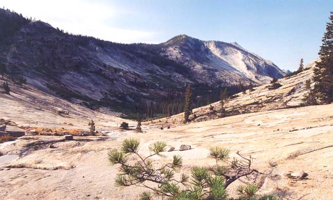 | 
| |
|---|---|---|
| First rock bowl (Photo by Clancy Rowley) | Yosemite valley from Lone Boulder |
From the Lone Boulder (37o47.15'N 119o29.17'W) note the talus slope that drops down ahead of you. Then identify a substantial band of bushes running up and down the slope to the left or west of the talus slope. You should descend the talus slope veering to the left to find your way through this band of bushes, perhaps with some bushwhacking. On the far side of the band of bushes is another rockslide or talus slope. Descend this rockslide veering toward its left side. Here you should begin to discern that you are on the apex of a slight prominence in the otherwise flat rock slope (37o47.09'N 119o29.59'W). The prominence is characterized by patches of bushes interspersed with rock slopes all the way to the valley bottom. A single large pine tree should become visible near the bottom of the prominence and the route proceeds directly down to this tree. The steepness of the rock slab here makes for a nervous descent but if you maintain a route with a group of bushes directly below you it eases the discomfort. If you feel uncertain on your feet, it is quite practical to descend the steepest sections by sliding on your rear end gripping the cracks with your hands. Near the bottom you pass by the single large pine tree and follow the rock slab down toward the left to a pool in Tenaya Creek at the bottom of an attractive sloping cascade. Here, at the end of the long descent you may choose to rest by the pool and have lunch. You should reach this point (elevation about 6250ft) roughly 2.5hr from the start.
 | 
| |
|---|---|---|
| Rock slab descent | Rappel into Inner Gorge | |
(Photos by Clancy Rowley) | ||
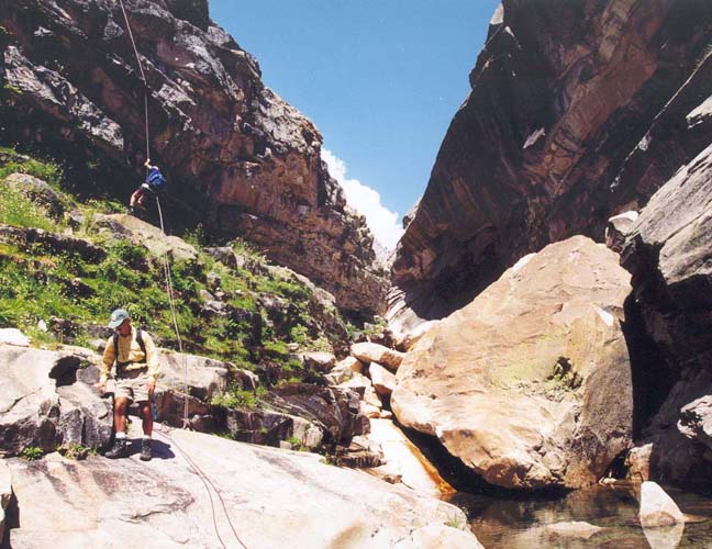
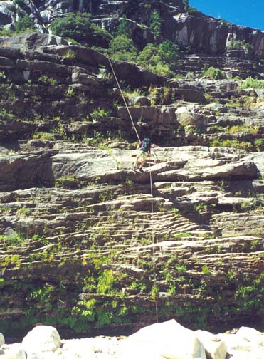
Follow the boulder-strewn creekbed downstream from the pool. Soon you enter a quiet and level section where the stream meanders through a beautiful forest. Appropriately this is known as the Lost Valley (37o46.87'N 119o30.09'W). After about 0.5mi, however, the going again becomes rugged with many streambed boulders. And quite abruptly you arrive at the top of the inner gorge where a dramatic, vertically walled canyon has been cut into the valley floor. You will notice several flat ledges on the right side of the canyon. Your route is along the large, lower ledge. But before taking that path, it is interesting to climb a few feet up to the higher ledge and follow it about 60yds along to a place where S.L.Foster carved his initials in the wall (37o46.75'N 119o30.16'W). Foster was one of Bob's predecessors in that he made annual trips down the canyon from 1909 to 1937 and this spot is now known as the ``Initial Ledge''. Someone has also installed a register in a plastic case in an alcove next to the initials. After this excursion, return to the start of the ledges at the head of the gorge and follow the lower ledge along to the rappel point beside a small pine tree growing out of the ledge lip. The knee-high anchor is relatively easily found and consists of two bolts with webbing and a rappel ring. From there it is a straightforward 40ft rappel into the bottom of the Inner Gorge. You should reach this point (elevation roughly 6000ft) about 5hrs and 5mi from the trailhead.
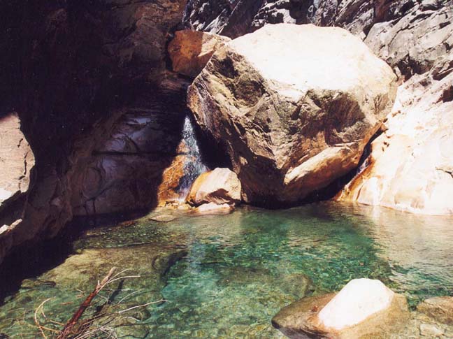
The transit through the bottom of the Inner Gorge is rough going. After one straightforward downclimb, you arrive at a 25ft drop with a large deep pool spanning the canyon below it. This obstacle was created by a huge rock (known as the Le Conte boulder) wedged between the canyon walls. You can downclimb the dry crack on the left side of the boulder though with some exposure. At the bottom you must then swim about 15yds to the downstream shore. The alternative is to rappel on the right beside the waterfall and then wade to the shore. Below the pool the canyon makes a dramatic descent through a very rugged section. Here there is much downclimbing. In general the easiest route is on the right, in one place crossing the top of a large rock slab holding onto the bushes for security. Just beyond this rock slab you descend the gully to the streamside only to be greeted by another steep cascade below you. Look to your right here and note what looks like a closed slot between two rock masses. However, if you proceed into this slot you will find a small hole that you can squeeze through to access the scree slope downstream of the cascade. From here stay up on the right side and some distance downstream you will find yourself on a large flat rock shelf with the stream in a deep gorge on your left. Continue on to near the end where the shelf peters out. There, near the edge of the gorge, you should find a rappel anchor consisting of two bolts with webbing and rappel ring. Using this anchor it is a straightforward 70ft rappel down into the bottom of the gorge. There is a non-downclimbable 70ft waterfall just upstream from this rappel so it is not useful to try to descend into the gorge before this anchor location. You should reach this point (elevation roughly 5500ft) about 7hr from the start.
 | 
| |
|---|---|---|
| The swim in Innner Gorge | The second rappel | |
(Photos by Clancy Rowley and Don Caldwell) | ||
Downstream of the second rappel the gorge proceeds through a narrow winding slot. The first obstacle is a waterfall that can be downclimbed in the slot on the right. This is followed by a sloping 40ft cascade that can be downclimbed but is much more safely rappeled using the bolt anchor installed in the rockface to the right of the stream. This cascade is notable for the large, deep hole in the rockface about two thirds of the way down. At the bottom of the cascade there is a pool that can be bypassed on the right. More boulder downclimbing follows until, quite suddenly, the slot ends and you emerge into a broad valley bottom at an elevation of 5250ft. This marks the end of the Inner Gorge (37o46.21'N 119o30.61'W) and it was here that John Muir spent the night after his fall. There is no more technical climbing but you still have a lot of rough ground to cover before you reach developed trails. You should reach this point about 7hr 45min from the start having covered about 5.4mi.
As you exit the gorge and follow the boulder-strewn streambed,
take the right fork where it splits for a short way. The streambed
gradually becomes flatter and the going eases. You pass under the
dramatic Watkins Pinnacles high above you on the right and the
Quarter Domes opposite them on the left. Continue to stay to the right
and look for the faint start of a use-trail on the wooded right slope.
The trail soon becomes clearer and easier to follow and continues for
several miles until, eventually, it arrives at the place where a
footbridge carries the Mirror Lake Loop Trail across the stream.
Here you follow a developed trail along the
right or north side of the canyon bottom, passing under Half Dome
and along the north side of the site of the old Mirror Lake. At the
Mirror Lake Visitor Center you begin hiking on asphalt road and follow
the signs through the end of the Yosemite Valley development
toward Curry Village. You pass over Clarks Bridge and around the west end
of the North Pines campground to reach the Backpackers parking lot and
your return vehicle
(37o44.17'N 119o34.01'W and
elevation about 4000ft). It takes about 10hrs
to complete the 10mi hike.
Last updated 9/1/00.
Christopher E. Brennen