ADVENTURE HIKES AND CANYONEERING
IN THE SOUTHWEST
© Christopher Earls Brennen

|
|---|

|
Hike M2. Matacanes
- Hiking time: 8 hours
- Estimated hiking distance: 6.5 miles
- Elevation gain: 360 feet
- Topo Map: INEGI Allende G14 C36
- Difficulties: 2 or 3 rappels up to 80ft, jumps up to 15ft, much swimming and some downclimbing
- Special equipment: Wetsuit, life jacket, helmet, harness, rappel device, 160ft rope, 8ft webbing
- Permit: None
-
ACA Rating: 3C IV

Characteristics
In the Monterrey Peaks National Park, west and south of the city of Monterrey, Mexico, there are a number of spectacular canyoneering adventures. In this collection we feature three canyons in this National Park, namely Chipitin, Matacanes and El Laberinto, the first two of which are world class adventures. Here we describe a descent of Matacanes, denoted on the topo map as Canyon Las Adjuntas.
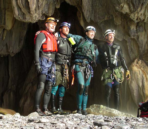
These are rugged limestone mountains riven through with caves and with travertine encrusted canyons. Like limestone canyons elsewhere the blue-green water positively glows in the sun and the luxurious temperate foliage adds the final touch to a magnificently scenic canyon environment. Both Chipitin and Matacanes involve much swimming and a wetsuit is really essential equipment. Furthermore the local authorities require every canyoneer in these canyons to wear a PFD (personal flotation device or lifejacket) so don't set out without one.
Trailhead
Access to Matacanes follows most of the same arduous route as access to Chipitin and involves a long drive up a very rough, mountain dirt road that requires a high clearance, 4WD vehicle. Moreover Matacanes also involves a long car shuttle for which you would need two high clearance, 4WD vehicles. The wisest choice is to contract with one of the local guide services such as Aventura (http://www.aventura.com.mx/) who are connected with the Hotel Hacienda Cola de Caballo, the best base for the three canyoneering adventures included here.
To get to Hotel Hacienda Cola de Caballo drive 36km south of Monterrey toward Cuidad Victoria on Mex.85 through the Villa de Santiago and turn off the highway at El Cercado where there is a signpost for Cola de Caballo. Drive 5.5km up NL20 to the hotel entrance on the right.
The starting point for the Matacanes adventure is the tiny village of Potrero Redondo (25o15.78'N 100o9.63'W) high up in the mountains. To reach Potrero Redondo from the Hotel Hacienda Cola de Caballo (elevation 2200ft) you continue up the asphalt road (Nuevo Leon 20 or NL20) for 5.5km to kilometer 11.5, the village of Puerto Genovevo (elevation 3640ft) where you turn sharp left onto a rough dirt road that is signposted to Las Adjuntas (10km) and Potrero Redondo (22km). This dirt road descends to a riverbed in Canyon Mauricio and follows this down to the small village of Las Adjuntas (25o18.03'N 100o8.42'W and elevation 2330ft) at a major river junction. There is a rural food stand here in Las Adjuntas, on the right just before the road crosses the river.
The river that enters from the right here is Matacanes and so you need to deposit one vehicle here before continuing along the road which climbs steeply after crossing the river. The road also gets much rougher as it climbs out of Las Adjuntas and then contours around the mountain finally reaching the village of Potrero Redondo (25o15.78'N 100o9.63'W) at an elevation of 4400ft about 12km from Las Adjuntas. During the last few kilometers look for the spectacular waterfall of Chipitin below you on the left.
It will take over 2hrs to drive from the hotel to Potrero Redondo. Just as you arrive in the village, turn sharp right onto the dirt road to Matacanes and proceed out of the village. Initially this dirt road is quite driveable but it gradually deteriorates and you should park and continue on foot where it becomes appropriate.
Hike
After leaving Potrero Redondo (25o15.78'N 100o9.63'W and elevation 4400ft), the dirt road rises and falls as it winds past small corrals and fields in shallow valleys of this plateau region. About 15min of hiking beyond Potrero Redondo at 4540ft the road forks and you should take the right fork that climbs another small rise. Eventually the road crests at about 4760ft and starts down a drainage of Matacanes canyon. You will probably decide to park and proceed on foot somewhere near this crest for the road soon becomes too rutted to drive and transitions to a pleasant trail in a wooded canyon.
 | 
| |
|---|---|---|
| Lagunasilla Cascade | Matacanes downclimb | |
(Photos by Ira Lewis and Michelle Nilles) | ||
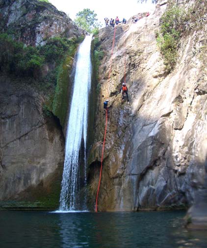
About 1hr of hiking time after leaving Potrero Redondo (and at 3900ft) you will pass some large boulders sitting in the middle of the wooded canyon and, shortly thereafter, the trail climbs the left side of the valley and then contours downstream, presumably to avoid some lesser obstacles. Fifteen minutes later, just after crossing a tributary and descending a short section of bedrock, you will come to the wide rock shelf and swimming pool at the top of the first rappel in Matacanes. Suit up with wetsuit, harness and helmet and then wade across the short pool to the lip of the 80ft vertical waterfall that marks the start of the wet descent of Matacanes. This is known as the Lagunillas Cascade (25o17.77'N 100o11.39'W). The distance from Potrero Redondo to Lagunillas Cascade is 4.5km (2.8mi), and it should take about 1hr 20min to hike.
 | 
| |
|---|---|---|
| Rappel into the first cave | In entrance to the first cave | |
(Photos by Ira Lewis and Michelle Nilles) | ||
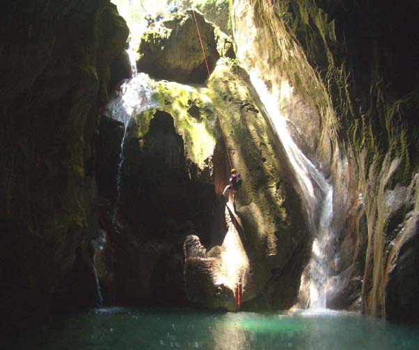
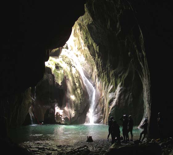
There are several good bolt anchors to the left of the waterstream for this 80ft rappel which ends with a swimming disconnect in the large pool at the bottom. You swim about 30m to the shore. After this first rappel there is a beautiful long and wide section of exquisite canyon with blue-green travertine pools, small falls and lovely foliage. Gradually the canyon deepens and narrows with some higher downclimbs and occasional overhangs with profusive limestone formations. Then, just beyond a short downclimb, you arrive at the gaping opening of the first cave, Matacan de Arriba, at an elevation of 3120ft. You should reach this point about 3hr 40min after leaving Potrero Redondo and about 1km (0.62mi) from Lagunillas Cascade. In the cavernous entrance to the cave, there is a 50ft vertical drop into a large swimming pool. There are several bolt anchors here: one on the nose in the middle of the lip and another on the right side where you rappel down through a hole into a slot on the right side. After the swimming disconnect you swim about 20m to a gravel beach inside the cave. Here, in the dim light, you need to put on your headlamp for the rest of the trip through the cave. Immediately, there is a small 10ft drop into a fairly shallow pool (4ft deep) that you could jump from the lower right side or rappel from the chockstone on the left. The cave get much smaller and darker here with great travertine rock formations all around. Next you will ease your way along a narrow chute with a swift flow. In the pitch dark this soon opens up again into a large pool-filled cave where you swim past marvellous rock formations toward a faint light at the end of the cave. In total, this first cave is about 80m long and a fantastic experience.
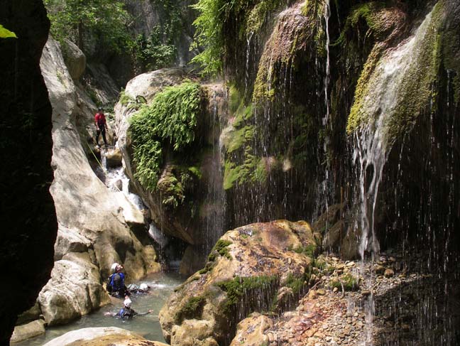
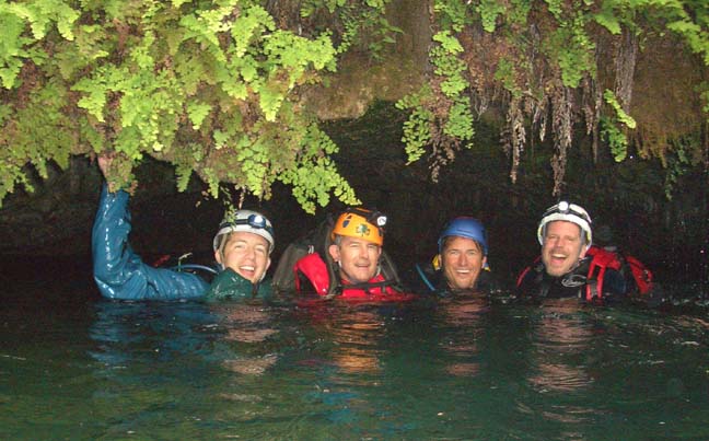
After the exit from the first cave, there is a long section of beautiful canyon with many jumps and many swims up to 100m long, usually in narrow slot sections. By judicious route finding you can get by without any jump of more than 15ft. There are also some great slides - one of about 30ft. Eventually the canyon narrows and you come to a really spectacular section of ``almost cave'' and swim through pools with overhangs that nearly touch above you, hanging ferns and profuse limestone rock formations. It is truly a special place. Near the end of this section you will come to an unavoidable 10ft jump into a deep pool that leads to a similar second jump into a pool at the entrance to the second cave, Matacan de Abajo. You should reach this point (elevation 2620ft) which is about 3km (1.8mi) from Lagunillas Cascade roughly 5.5hrs after leaving Potrero Redondo.
 | 
| |
|---|---|---|
| In entrance to the first cave | Exit from the second cave | |
(Photos by Michelle Nilles and Ira Lewis) | ||
You should pause on the shelf at the entrance to this second cave to switch on your headlamp before entering. Then you start down a very slight chute to the swimming pool that extends through the entire length of the cave. This cave is smaller, narrower and slightly longer than the first - about 100m. Again there are spectacular rock formations and small side caves that you can swim into. When you turn a corner you see the slit of light that comes through the very low ceiling exit that is also overhung with ferns. The headroom at the exit is only about a foot.
Here after emerging from the Matacan de Abajo, 6hrs after leaving
Potrero Redondo, you encounter signs of human passage with fireplaces and
some unfortunate litter. Another section of slot swimming and small jumps
follow. Eventually the canyon broadens, you make the last swim and there is
an occasional use trail down the canyon. About 45min from the last
swim you finally come to the end of this adventure and reach Las Adjuntas
(25o18.03'N 100o8.42'W and
elevation 2360ft). The hike from Potrero Redondo takes about
8hrs and covers 10.4km (6.5mi).
Last updated 5/16/05.
Christopher E. Brennen