ADVENTURE HIKES AND CANYONEERING
IN THE SOUTHWEST
© Christopher Earls Brennen

|
|---|

|
Hike Q1. Knox, Red and Hancock Gorges, Karijini National Park
- Hiking time: 5.5 hours
- Estimated hiking distance: 1.8 miles (2.9 kilometers)
- Elevation gain: 300 feet (91 meters)
- Topo Map: Karijini National Park, Western Australia
- Difficulties: 1 rappel of 20ft, 4 long swims over 100m, one over 300m, one protected traverse of 60m
- Special equipment: Helmet, harness, rappel device, one 100ft rope, about 8 carabiners, wetsuit (all equipment provided on guided descent)
- Permit: Guided Tour with West Oz Active (www.westozactive.com). Price: A$215
-
ACA Rating: 3C III

Characteristics
Karijini National Park, at 6274 square kilometers the second largest Park in Western Australia, is a jewel hidden away in the outback of northwest Australia, in a region known as the Pilbara. This desert landscape is covered with grass called spinifex and scattered with a variety of trees. Huge termite mounds are a feature of the scenery that is almost devoid of people. In the cooler months the land is covered with yellow-flowering cassias and wattles, northern bluebells and purple mulla-mullas. After rain many plants bloom profusely. The wildlife includes red kangaroos, euros, wallaroos, echidnas, geckos, goannas as well as a large variety of birds and snakes including pythons.
Today the Pilbara is home to a few remnants of the original Aboriginal inhabitants and to some scattered mining operations that, nevertheless, exercise considerable influence over most of the affairs of the region. Karijini National Park (which used to be called the Hamersley Range National Park) is the traditional home of the Banyjima, Kurrama and Innawonga Aboriginal people, the new name Karijini meaning "hilly place" in the Banyjima tongue. Evidence of their occupation dates back more than 20,000 years.
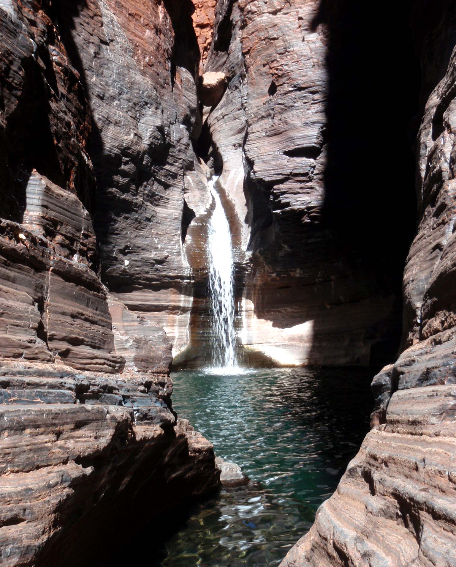
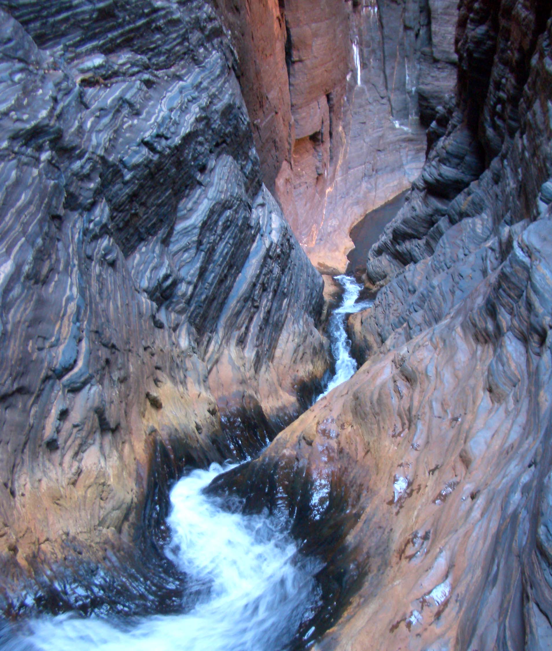
Karijini is special because here the Joffre River and its tributaries have cut deep, vertical gorges into what is otherwise a flat and quite featureless desert landscape. During the summer, rains fill the aquifers in the ancient rock of this land and the resulting springs cause water to flow in the gorges for most of the year. This water has cut narrow and crennelated canyons that provide a number of spectacular canyoneering adventures. About a mile-long stretch of the main canyon is known as the Red Gorge though the watercourse further downstream is known as the Wittenoom Gorge. The Red Gorge lies at the heart of these adventures and, like its major tributary Joffre Gorge, it contains long cold pools bounded by vertical red walls. As described below, some planning is required to comfortably negotiate these pools. The principal tributary gorges that feed into the Red Gorge are Joffre, Hancock, Weano and Knox Gorges. Only Joffre and Hancock can be ascended (though, in the case of Hancock, this requires some technical equipment); consequently all canyoneering adventures consist of a descent through one of these gorges and an end-of-day ascent through either Hancock or Joffre. In this account we describe a descent through Knox Gorge, a trip up Red Gorge and an ascent via Hancock Gorge. In the companion adventure the descent is through Weano Gorge and two alternative ascents aof Joffre Gorge are described.
Since the winter months of July, August and September bring rain and the water is very cold and since the plateau temperatures can be very hot in the summer, the best time to visit is probably in the fall months of April or May. There are only a couple of campgrounds in this widely spread out Park and only one place to find a bed for the night or a meal, namely the new Eco-Retreat (http://www.karijiniecoretreat.com.au) that, in addition to a campground, rents tents with beds. The Retreat (22o23.176'S 118o16.602'E) is also the hub of all current Park activities and is within hiking distance of the gorges described above. If you plan to follow either of the adventures described here, I would recommend that you sign up for a guided tour with West Oz Active Adventure Tours (http://www.westozactive.com.au) based at the Eco-Retreat who provide all the equipment you need. The owner, Danny Francis (email: info@westozactive.com.au) is the local canyon expert. If you wish to canyoneer on your own then you need to have a nationally recognized accreditation to abseil (rappel) and be lead by a qualified and acredited leader.
Trailhead
It is not easy to get to Karijini National Park. One way is to drive about 750mi (1200km) north from Perth, mostly along the lonely Great Northern Highway (the park is just north of the Tropic of Capricorn). Another way is to fly from Perth to Paraburdoo, a small mining town whose airport is the closest to the park, and rent a car. This airport also serves the slightly larger mining town of Tom Price, 50mi (80km) away. The Eco-retreat is another 50mi from Tom Price, and a large part of this is dirt road.
This adventure requires a car shuttle. To deposit the return vehicle, exit the Eco-retreat (22o23.176'S 118o16.602'E), turn right and drive about 6mi (10km) to the end of the road at the Weano Picnic Area and the Weano and Hancock trailheads (22o21.476'S 118o17.143'E). Park the return vehicle here and then drive back past the Eco-retreat for 8.5mi (14km) to the junction with Banjima Road. Turn left heading for the Knox Gorge trailhead and overlook. After 2mi (3km) turn left again, following the signs for Joffre Falls/Gorge and Knox Gorge. The road to the Joffre Falls overlook branches left after 1.3mi (2km) but you continue on for 2.5mi (4km) to the end of the road at the Knox Gorge overlook and trailhead (22o22.271'S 118o17.778'E). The trail down to the bottom of the gorge begins beside the information board.
Hike
From the Knox Gorge trailhead information board hike down the steep trail to the bottom of Knox Gorge. You may wish to walk a short distance upstream (right) in order to view a beautiful, verdant pool decorated with Native Fig trees and Paper Bark Gums. Then hike downstream past other small pools as the gorge begins to narrow and the vegetation disappears. About 1hr from the start you arrive at the start of the narrows where you first descend into a waist-deep pool before encountering a notice that warns you of the dangers immediately ahead. A narrow steep section of about 30yds follows before the bottom drops out. You are now at the top of the Knox Slide and there are two descent options. The first option is to rappel down the 35ft drop using the three solid bolts installed in the left wall as the anchor; this rappel requires a swimming disconnect in the deep pool at the bottom. The second and much commoner option is a sliding descent. This involves a slide of about 25ft before being launched into a free-fall of another 12ft. You land in a deep cliff-ringed pool about 35ft in diameter. It is an easy swim to the slot exit from this pool. However the slot is only about 30ft long and, at the end of it, you encounter another vertical drop of about 20ft into another cliff-ringed pool. Here, however, you must rappel since the pool is usually only knee-deep in the landing area. For this rappel there are bolts installed in the left wall. Once at the bottom, the pool deepens near the discharge slot and you must again swim to that narrow slot exit. Here logs caught in the slot ease the climb out of the pool. The exit slot is very short and you almost immediately emerge into the much broader Red Gorge. This exit from Knox Gorge is at 22o21.941'S 118o17.915'E, 0.52mi and 2hrs from the morning start. Your route upstream in Red Gorge is to the left.
 | 
| |
|---|---|---|
| Knox Gorge Slide (Photo by Brydie O'Connor) | Knox Gorge exit (Photo by Brydie O'Connor) |
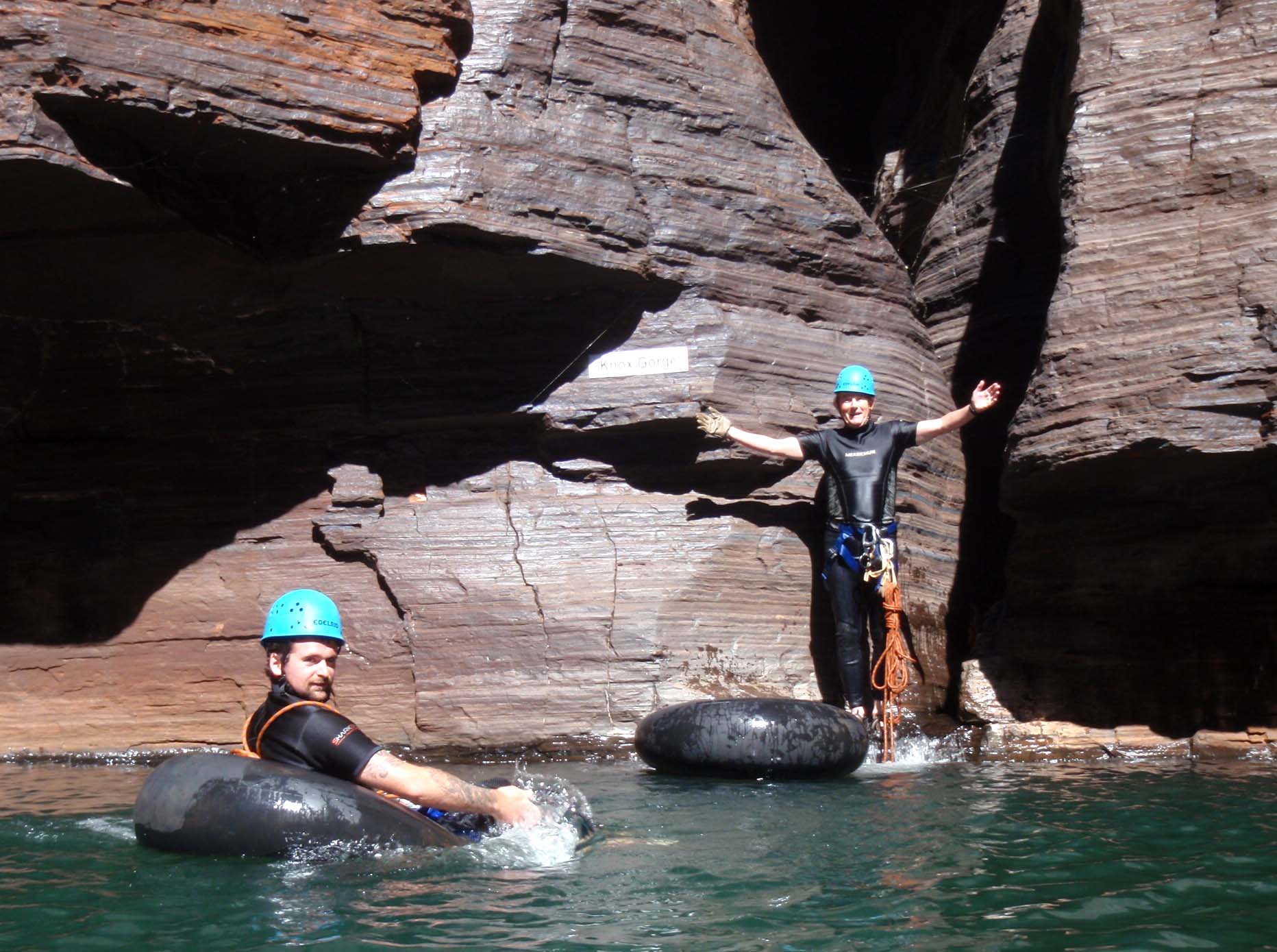
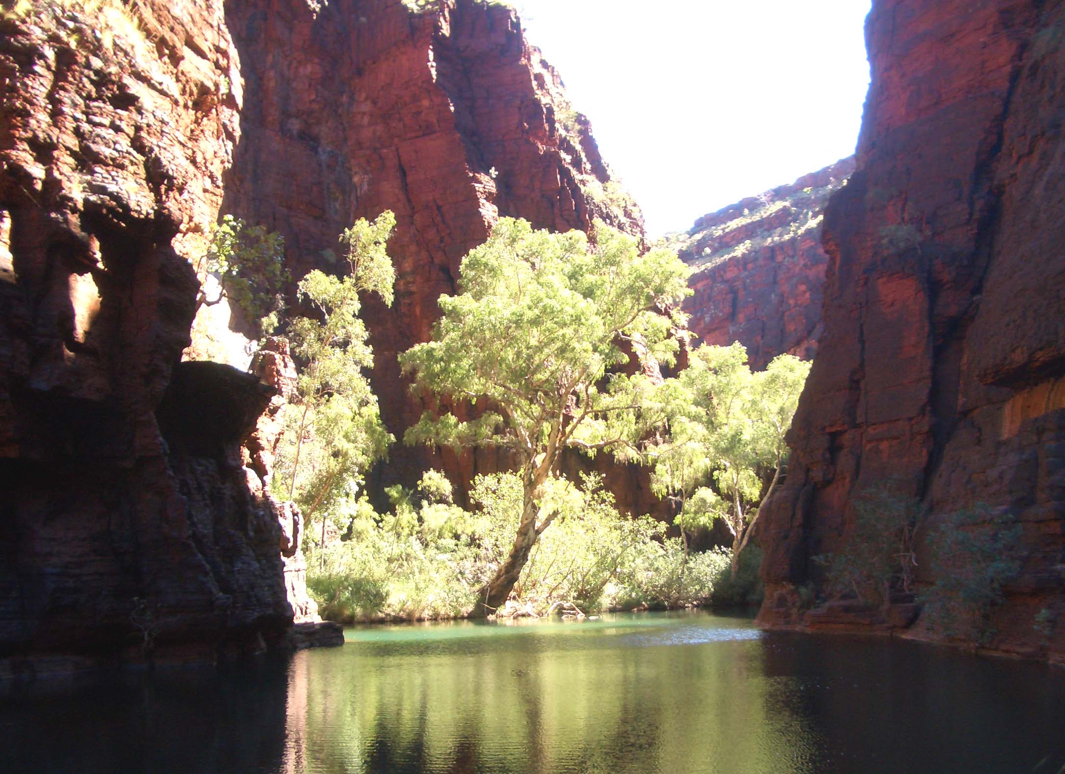
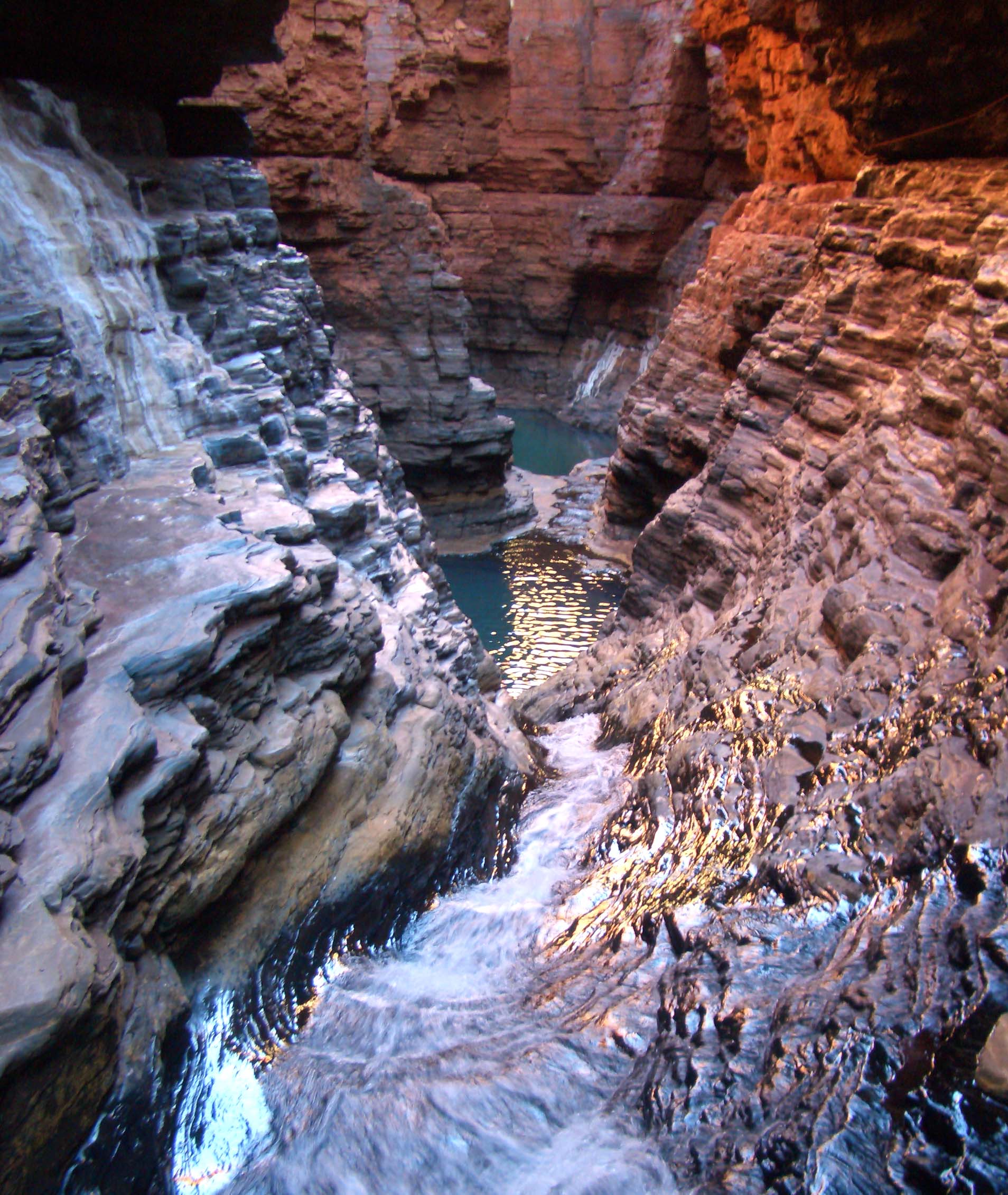
At the Knox Gorge exit, you immediately face the first major swim/float though you may choose to swim first to the gravel bar just opposite the exit in order to prepare for the Red Gorge transit. This is where you should deploy any swimming or floating aid you have brought (an inner tube?) for there are four long swims/floats ahead. In particular, a floating aid like an inner tube will allow you to enjoy the splendour of the Red Gorge and to avoid hypothermia for the water of the Red Gorge pools is deep and cold (since they don't get much sunshine). The transit of the Red Gorge from the Knox Gorge exit to Junction Pool involves four long, canyon-filling swims/floats, the first, second and fourth being about 100yds long while the third is over 300yds long. The boulder flats between these swims are short. The third pool is particularly scenic and decorate with small beaches with fig and gums trees. After the fourth pool you will pass the spectacular, 120ft Weano Falls on your right; a descent of these falls is included in the second Karijini adventure in this collection. Junction Pool is just beyond Weano Falls and encompasses the exits of both Joffre Gorge and the much smaller Hancock Gorge. You should reach Junction Pool at 22o21.688'S 118o17.379'E about 3.5hrs from the start having covered just 1.2mi. Usually there is a welcome patch of sunshine on the rocky beach of Junction Pool and it provides a nice lunch spot. High above Hancock Gorge you will be able to see the Junction Pool overlook that is as close as many tourists get to this gorge.
|
|---|
| The third pool in the Red Gorge |
Parenthetically it is worth noting that there are two possible continuations of this adventure. One possibility which we will not cover here would be to continue upstream through Joffre Gorge. This transit through Joffre Gorge to Joffre Falls is about 2.7mi (4.4kms) long and takes at least 6hrs since it involves many additional swims/floats similar to those of the Red Gorge. The terminus is the spectacular Joffre Falls which are adjacent to the Eco-Retreat. The climb out of the Joffre Gorge is on your right about 50yds before the falls themselves. The ascent route up a steep side canyon is clearly marked with yellow triangles and the trail at the top leads back to the Eco-retreat just about 100yds away.
However, we describe here another option, namely an ascent of Hancock Gorge. Not only is this more spectacular but it is also much shorter than the Joffre Gorge option. First you must swim across Junction Pool to the narrow opening leading into Hancock Gorge. Just inside the gorge there is a flat area where you should pack your floatation device and otherwise prepare for the climbing ahead. Just about 20yds into the narrow and deep gorge you turn left and arrive at the bottom of the long narrow cascade known as the Chute that drops about 100ft down through some of the oldest rocks in the world. The climb up the Chute is quite straightforward; you should pause to inspect these layer of rock some 2.5 billion years old. At the top of the Chute you turn left and arrive at a much wider and flatter section with a large pool that you can pass on the left or right. This is followed by a small cascade that leads up to the bottom of the cliff-ringed Regan's Pool.
 | 
| |
|---|---|---|
| The Chute in Hancock Gorge | Looking down Hancock Gorge at Regan's Pool |
The beautiful Regan's Pool is named after the volunteer rescue team member, Jim Regan, who was swept to his death in the Chute by a flash flood that occured while he was participating in a rescue in Hancock Gorge. The other rescuers (and the injured person) survived the flash flood by being beached before the Chute. To ascend Regan's Pool you need to follow a high ledge on the left that is equipped throughout its length by secure bolts. The guided tours set up a safety line here and provide each customer with cowtails to secure themselves as they traverse about 60ft above the pool. Non-guided canyoneers should split into pairss and execute a horizontal pitch (or two) using carabiners and the line of permanent bolts to secure their traverse. Care is needed here since the much-used footholds can be very slippery when wet.
Above the short cascade that leads to Regan's Pool you encounter another lovely pool known as Kermit's Pool. This is the point where hikers must halt during a descent of Hancock Gorge if they are not equipped with technical gear so you may encounter an audience at this point. You can bypass Kermit's Pool on either the left or the right. A narrow section known as the Spiderwalk follows and this ends in a broad section known as the Amphitheater. Here the raw rock of the gorge ends and the canyon becomes more open and greener. You should reach this point about 5hrs after the morning start.
Upstream of the Amphitheater, there are several moderately long pools that
can either be waded/swum or bypassed by the narrow ledges on the left. This is followed by a 100yds
section of easy hiking that leads to a ladder on the right that marks the start of the climb out of
Hancock Gorge. You climb the 20ft ladder
(at 22o21.516'S 118o17.117'E)
and proceed up the steep trail to the plateau above. The Hancock Gorge trailhead and the Weano picnic
area where you should find the return vehicle are just a few yards away at
22o21.476'S 118o17.143'E. The hike should take about 5.5hrs during which
you will have travelled 1.8mi.
Last updated 6/11/09.
Christopher E. Brennen