ADVENTURE HIKES AND CANYONEERING
IN THE SOUTHWEST
© Christopher Earls Brennen

|
|---|

|
Hike H2. Half Dome
- Hiking time: 15.7 hours
- Estimated hiking distance: 29 miles
- Elevation gain: 3500 feet
- Topo Map: Yosemite National Park Topographical Map
- Difficulties: Steep climb up and down the Half Dome cableway
- Special equipment: Leather gloves
-
ACA Rating: 3A V

Characteristics
Half Dome adorns the great valley of Yosemite like a crown jewel. Its symmetric shape and sheer polished walls are known throughout the world and people flock to this corner of California to see Half Dome and the other colossal monuments of Yosemite National Park. It was Abraham Lincoln who set a marvellous precedent for the world when he signed the bill in 1864 establishing Yosemite as the nation's first state park; twenty six years later it became a National Park. And yet the magnificence was revered before the white man ever set foot in this land of spectacular natural beauty. The Yosemite Indians who lived on the floor of the valley must have wondered about the awesome monuments around them for they created stories to explain their existence. The legend of Half Dome tells the tale of a young married couple, Tis-as-ack and and her husband Nangas, who disturbed the peace of the valley when he abused her and she retaliated. In retribution, the gods turned them into cliffs of granite that face each other silently and forever. The husband Nangas became the Royal Arches and his wife, Tis-as-ack was transformed into Half Dome. The Yosemite point to the dark streaks rolling down the great face of Half Dome and claim they are the tears of Tis-as-ack as she ran from her husband.
The geological story is nearly as dramatic and tells of a great projection of granite sheared in half by the glacier that formed Yosemite Valley. Today the 8836ft monolith continues to be weathered by the ice that sheds slabs off the surface in a process likened to the peeling of an onion. But this occurs over geological time. Over climbers' time the rock is quite stable (despite the occasional rock falls). Yosemite is often called the world center of big wall climbing. Many techniques developed on the awesome walls of El Capitan and Half Dome revolutionized the sport. In part this was due to the high quality of the granite for, embedded in the granite, are nodules of harder rock that provide excellent natural handholds. And so today Half Dome is a favorite with big wall climbers who regularly find their way up the sheer northern face of the monument, past the tears of Tis-as-ack. The other sides of Half Dome are less steep but still present a serious rock-climbing challenge. The easiest of the routes is up the eastern shoulder where the slope gets down to a still very steep 46 degrees. This route was first climbed by George Anderson in 1875; then in 1919 a system of cables anchored to the rock was installed and, for the first time, allowed the summit to be attained without technical equipment. The route, the subject of this adventure, is still challenging and dangerous with breath-taking exposure. But it is within the capability of the experienced hiker.
But before Half Dome, this adventure hike begins in Tuolomne Meadows and travels through some of the most beautiful high mountain scenery in the world. It then follows a long, cross-country route to the back of Half Dome. After an overnight stay, you climb Half Dome early in the morning before the crowds arrive. Descending from the peak you then follow the popular trail past Nevada Falls and Vernal Falls down into Yosemite Valley.
Trailhead
The hike requires a backcountry permit that you can obtain from from the Backcountry Office in Yosemite Village. They will also supply you with a parking permit and a map showing the location of the parking lot for overnight hikers. The Backcountry Office also rents bearproof food cannisters at a very reasonable price and I strongly recommend renting one of these for bear predation on backpackers food has reached epidemic proportions.
Then, early on the first morning of your hike at about 7.30am, after parking your vehicle in the appropriate lot (37o44.05'N 119o33.88'W), you should catch the valley shuttle bus to Yosemite Lodge. There you can breakfast in the Lodge cafeteria before catching what is known as the hikers bus bound for Tuolumne Meadows. Leaving from Yosemite Lodge every morning at 8.20am, the hikers bus first stops at Crane Flats gas station before proceeding along the Tioga Road where it stops by request at any trailhead on the way to its terminus at Tuolumne Meadows. The stops may include White Wolf, Yosemite Creek, Olmsted Point and both ends of Tenaya Lake before reaching the stop for this hike, namely the Cathedral Lakes trailhead (37o52.41'N 119o22.97'W) just a mile or so before the terminus.
Hike
Tuolumne Meadows (elevation 8600ft) and the surrounding high country is some of the most beautiful country in the world. The combination of buff granite monuments, conifer forest, lush natural meadows and crystal streams, cascades and lakes creates an environment that glitters in the summer sunshine and in the winter snows. There is an inevitable sense of exhileration as you start up the trail south of the Cathedral Lakes trailhead (37o52.41'N 119o22.97'W and elevation 8560ft). From the meadows, the trail climbs gently through open conifer forest and across small alpine meadows as it rounds the western side of Cathedral Peak. Initially the view backwards includes Tuolumne Meadows but as the trail turns and rises there are some scenic views of Fairview Dome to the north. After about 1hr 40min and 3.1mi you come to the junction (elevation 9360ft) with the spur trail down to lower Cathedral Lake; keep to the left along the main trail and you will arrive at the beautiful upper Cathedral Lake (elevation 9585ft) about 15min later. This is a truly magnificent place and a delightful lunch spot. If you have time a circuit of the lake will provide some great mirroring views of the twin spires of Cathedral Peak (10940ft) and Eichorn Pinnacle towering over the eastern shore of the lake.
|
|---|
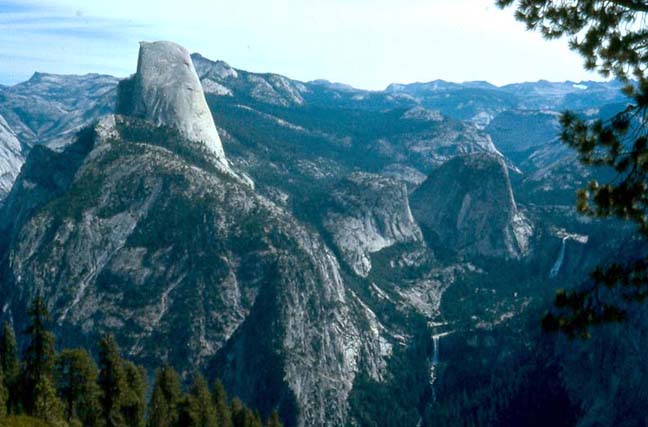
| Half Dome from Glacier Point with Nevada and Vernal Falls on lower right |
Leaving Cathedral Lake, it is a short climb to the shallow Cathedral Pass (37o50.08'N 119o24.94'W, elevation 9680ft and 2hr 10min from trailhead) where you enter a very pretty flat meadow, the starting point of Echo Creek that flows south into Little Yosemite Valley. This is gentle high country and the trail contours gradually along the right side of the meadow and the lower eastern slopes of Tresidder Peak as it rises slowly above the valley. Eventually it reaches the ridge and rounds the base of Columbia Finger before rapidly descending the other side of the ridge into another beautiful meadow, Long Meadow. Once in the meadow, it then meanders downstream beside the stream until, 7.1mi from the start, it arrives at the marked junction with the Echo Creek trail (at 9320ft). This fork is at the head of a lower section of the aptly named Long Meadow and you take the main trail that continues along the right side of this large meadow. After travelling south for a spell, the route leaves the main stream and follows the right edge of the meadow as it turns right up into a short side branch. Just after this right turn you pass Sunrise High Camp (37o47.72'N 119o25.96'W, elevation 9280ft and 8mi from start) built on the rocks a little above the meadows on the right. You will reach Sunrise (8mi from the trailhead) about 4hr 40min after setting out.
 | 
| |
|---|---|---|
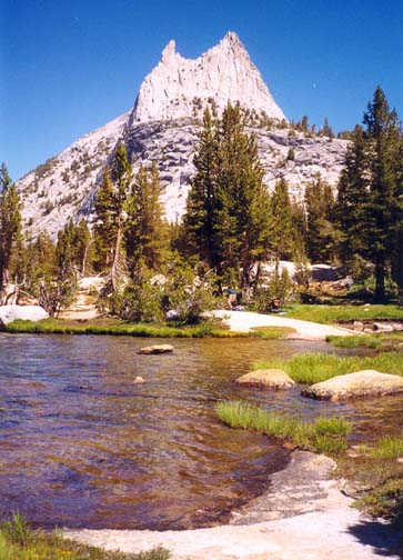
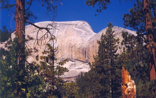
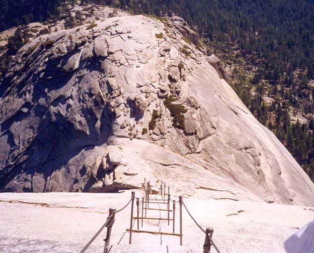
| Cathedral Lake and Peak | Half Dome from the back |
Beyond Sunrise, the trail rounds the head of this side branch of the meadow and arrives at a trail junction, the left fork being the way to Half Dome and the Valley. Beyond the fork, it climbs a short way to a saddle and crosses a stream with the last water for a few miles. There follows a long gradual climb along the side of Sunrise Mountain; eventually this culminates in a broad ridge saddle with the first spectacular views toward the monuments of Yosemite Valley. The trail then begins a steep switchbacking descent of about 1200ft beside a small creek. At the bottom of this tough descent, the trail flattens out into a welcome easy stretch through dense forest and then transitions into another long flat section in a natural trough along the top of an ancient moraine. This brings you (13.7mi from start) to two trail junctions in rapid succession: the first at 8200ft is the Forsyth Trail joining from the right and the second at 7880ft is the high trail left to Merced Lake. The main route then contours into the small valley of Sunrise Creek, a fine clear stream with great drinking water. You descend first along the left bank and later cross to the right. The proximity of the upcoming junction with the Clouds Rest trail can be judged by the increasing frequency of obvious but unofficial backpacking campsites.
You should arrive at the junction with the Clouds Rest trail (7200ft and 16.4mi from start) about 7hr 40min after setting out. There are many attractive campsites scattered about in the forest around this junction including a number along the banks of Sunrise Creek. It is an excellent place to camp overnight. There is a particularly nice site atop the rocks just a few yards up and to the left of Clouds Rest trail. The only problem is that bears regular tour these sites looking for food. Thus it is wise to have a bearproof container in which to store your food overnight.
Setting off the next morning, you travel down the trail toward Half Dome with increasingly spectacular views of the rock. After contouring along the east end of the base of Half Dome for about 0.7mi, you arrive 20min from the start at the junction with the spur trail that leads up toward the monolith. The junction at 37o44.72'N 119o30.73'W and an elevation of 7000ft is 17.1mi from your Tuolumne Meadows starting point. Stow your pack out of sight of the trail and carry only your waterbottle, wallet, camera and warm jacket as you hike up the steep trail toward Half Dome, 2.6mi away. The initial climb follows a series of switchbacks up a steep wooded slope that eventually reaches an overview of Yosemite Valley and Tenaya Canyon. Then it climbs the apex of a wooded ridge, approaching Half Dome from the east. This culminates in a broad level gathering site at the top of the wooded ridge. Here the trail makes an abrupt transition onto steep, bare rock and increased care must be taken on a number of accounts. Not only is there the danger of a substantial fall but also, as the signs warn, a very real danger from lightening when storms are threatening. Large signs warn you not to proceed any further if there is any sign of an impending storm.
 | 
| |
|---|---|---|
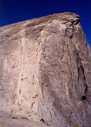
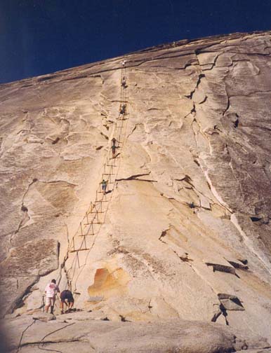
| From the Half Dome trail | Half Dome cableway |
Rock steps have been constructed on this steep rock slope and allow fairly easy though slow upward progress. Now you begin to recognize the increasing exposure and the increasing heights below this switchbacking stairway. Gradually the slope lessens and you climb onto a bare rock shoulder on the east side of Half Dome. This is the shoulder that is readily visible from far below and, looking down, you recognize just how far you have climbed up the monolith.
But this is nothing compared with the sight directly ahead of you as you broach the shoulder. Suddenly, the most amazing sight presents itself. On the other side of a shallow saddle separating the shoulder from the peak of Half Dome is a very steep ``trail'' straight up a seemingly smooth, vertical rock face to the summit about 400ft above you. It is awe-inspiring not only for its apparent verticality but also for its exposure and height. The ``trail'' ahead consists of two thick steel cables about 3ft apart. At intervals, these are are anchored to bolts fixed in the rock face; they are also raised above the rock surface by passing through loops on the tops of steel posts loosely set in holes drilled into the rock. A two-by-four is laid across between the pairs of posts to act as a step for resting.
Before starting up this intimidating trail, you should rummage through the large pile of gloves at the bottom and try to find a pair is only a modest state of disrepair. Unless, of course, you had the excellent foresight to bring your own gloves. If so I strongly recommend a pair of leather workman's gloves.
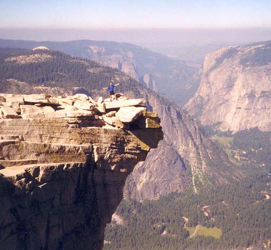
From the shoulder the trail up the cable way looks exceedingly frightening and quite vertical. Many decide not to proceed but to watch their fellow hikers tremble their way to the top. However, the ascent is not as scary as it looks. Despite the exposure it is a fairly easy, though tiring climb. In fact the slope is only about 46 degrees. There is a short, steeper section in the middle of the ascent and there it is preferable to have good soles on your hiking boots (sneakers would be much less secure). Near the top the slope eases and, all of a sudden, you are but a few yards from the 8842ft summit of Half Dome (37o44.77'N 119o32.00'W). This is right on the edge of the famous, vertical face you view from the valley below and in just a few yards you can look straight down 4800ft to the floor of Yosemite Valley. It is a truly awesome view. To the west you see busy Yosemite Valley and the prominent profile of El Capitan. To the northest you look up Tenaya Canyon and Tenaya Lake can be seen in the distance. To both the north and south are breathtaking views of the rugged high country of Yosemite National Park.
There is one prominent rock projection that juts out from the summit over the top of the 4800ft vertical face. Known as the ``diving board'', it makes for an awesome photograph. However, all too soon it is time to start back down. Some find the descent more frightening than the ascent because you must look down rather than up to see where you are going. The security of leather gloves and lug-soled boots are particularly reassuring. The rest of the descent to the trail junction is uneventful by comparison.
 | 
| |
|---|---|---|
| On the ''Diving Board'' | Looking down |
You should arrive back at the Half Dome trail junction (22.3mi from the start) about 3.5hr after the morning start. From there you proceed down the steep, rocky trail (2.2mi) to the floor of Little Yosemite Valley (6080ft). There the serene Merced River winds along the floor of Little Yosemite Valley, providing a fine rest spot and a place to fill up with enough water for the rest of the day. The trail follows the quiet course of the Merced for about half an hour and then, about a mile from where it first came down to the valley floor (and at 25.7mi from start), it begins a sudden and precipitous drop down a dramatic cleft to the left of main course of the river. A short way down this steep descent, a marvellous view of the spectacular Nevada Falls (37o43.51'N 119o32.05'W) is unveiled. The crashing spray and thunder of the falling water reverberates the rock and generates localized rainfall. It is a spectacular sight.
Below the base of the Nevada Falls, the trail crosses a bridge over a
dramatic water chute and
decends the left side of the river past a lovely little lake, a great place
for a swim. Many tourists
from the valley ascend this far and so the crowds increase as you
progress. Shortly you will arrive at the top
of Vernal Falls. The route around this obstacle is a steep staircase
along the cliff wall on the left. A restroom
and water fountain at the base of this descent cater to the now
excessive crowds. Another bridge leads back to the right side of the
canyon for the last leg down along an easy asphalt trail to the valley
bottom at Happy Isles
(37o43.96'N 119o33.52'W, elevation
4035ft and 28.8mi from the start). There
you should cross to the left bank of the river and find the Happy Isles
Shuttle Stop. The hiker's parking lot
(37o44.05'N 119o33.88'W)
is a short walk along the road
toward Curry Village. You should reach there about 7hr 40min after
the morning start.
Last updated 9/9/99.
Christopher E. Brennen