ADVENTURE HIKES AND CANYONEERING
IN THE SOUTHWEST
© Christopher Earls Brennen

|
|---|

|
Hike N1. Grand Teton
- Hiking time: 3 days
- Estimated hiking distance: 18 miles
- Elevation gain: 7038 feet
- USGS Topo Map: Moose, Grand Teton
- Difficulties: Technical rock climbing (up to 5.5) with huge exposure in places
- Special equipment: Full technical rock climbing equipment, 2 120ft ropes, 2 No.1 cams, 2 No.2 cams, assorted hexes and nuts, 6 4ft slings, 6 quickdraws, helmets
-
ACA Rating: 4A VI

Characteristics
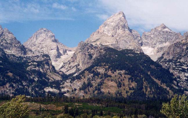
The Grand Teton is an awesome pinnacle of rock and ice that soars above the flat plain of Jackson Hole, Wyoming and presents a magnificent mountaineering challenge and a spectacular wilderness adventure. In this chapter we describe a three day ascent of this fabled 13770ft mountain by the classic Owen-Spalding route, the route by which it was first climbed in 1898.
Native Indians called them the "Hoary Headed Fathers", but when the French trappers of the Hudson Bay Company came upon them they called them "Les Trois Teton" or the "Three Tits", a name that stuck and by which the South, Middle and Grand Teton are now known. I remember driving westwards through Wyoming in 1970 and, upon cresting the Togwottee Pass, seeing the magnificient Teton range for the first time. Piercing the western horizon, they were the most magnificent mountains I had ever seen, rugged monoliths of rock and ice rising precipitously into the sky. Preoccupied with my family vacation, I little thought that someday I would return to climb the highest of those pinnacles, the 13770ft Grand Teton.
The beauty of the mountain range and the surrounding area was recognized early in the modern era when the Grand Teton National Park was created in 1929. The mountains, glaciers, lakes and abundant wildlife continue to make it a national treasure and a particularly popular destination for hikers and climbers. It is one of my favorite parks and you should take time out from the specific objective described here to enjoy the multifaceted beauty of the place.
We describe an ascent of the highest mountain in the park, the 13770ft Grand Teton that towers 7000ft above the flat-bottomed Jackson Hole valley that bounds the range on the east. It is a magnificient monument of raw granite, overwhelming when you first view it from the valley below. The route described here is known as the Owen-Spalding route and is that by which William Owen, Frank Spalding, Frank Peterson and John Shive first attained the summit on Aug.11, 1898. Though most of the ascent is a matter of finding your way up steep talus slopes, the last 600ft up the summit block requires technical rock climbing know-how and technique, as well as the ability to handle the exposure that can be several thousands of feet in places. The rewards are spectacular views of these magnificent mountains from a truly remarkable vantage point.
The climbing skills required may depend very much on the weather and the time of year. When the cracks, chimneys and crevices of the summit block are lined with ice or filled with snow they present a formidable climbing challenge. This account does not address those difficulties. We will assume that you are going to tackle this adventure in late summer when the route is usually (but not always) free of ice. Then with only a few moves above 5.4, most of the climbing challenges would be modest if they were at the level of the valley below. On the other hand the weather, route finding and massive exposure add considerably to the challenge and make this by far the hardest adventure described in this collection.
We will also assume that you will not be hiring a guide service but will be facing the logistical, navigational and technical challenges with a small group of friends. To do so successfully using one's own resources adds especial pleasure when you make it to the summit. But if you feel this is too much of a challenge, you may wish to sign up with the Exum Guide Service who take groups to the summit almost every day in the summer. They will house you in their hut at the Lower Saddle so that you do not have to haul tents, sleeping bags, cooking equipment and climbing ropes up the mountain. You will leave the hut before dawn on the second day and be taken to the summit, guided and belayed through all the technical sections. The guides plan to summit in mid-morning so as to avoid the thunderstorms that often roll in after noon, making the summit block a serious lightning strike danger. They usually descend all the way to the trailhead late in the afternoon of this second day.
Trailhead and Arrangements
The trailhead is the large parking area at Lupine Meadows (43o44.09'N 110o44.49'W and elevation 6732ft) about 1.5mi down an asphalt and dirt turnoff from the main Teton Park Road. The Teton Park Road can be accessed from two points along the Interstate labelled both 89 and 191, a road that runs north/south through both Grand Teton National Park and Yellowstone National Park. The Lupine Meadows turnoff is about 7mi north of Moose Junction (where the southern Park Entrance is located) and 0.5mi south of the Jenny Lake Visitor Center and Ranger Station. Since some might arrive by air it should be noted that the small Jackson airport is just about 4mi south of Moose Junction; it is a relatively short taxi ride from there to the trailhead.
Most people embarking on this multiday adventure will need a place to stay near the trailhead for the night before and, perhaps, the night after the hike. One possibility is the tent-only National Park campground at Jenny Lake that is very full in the summer and difficult to get into; there are, however, other National Park campgrounds somewhat further away, for example the large campground at Gros Ventre. Another possibility is Climber's Ranch located at the end of another turnoff 2.5mi south of the Lupine Meadows turnoff and 4mi north of the Park Entrance on Teton Park Road. The ranch was built specially for climbers and consists of a group of cabins with rough bunk beds plus central dining shelter, washing and bathroom facilities. The cost is $6 per person per night. The place has great atmosphere and camaraderie; and others more knowledgable about the Tetons will be happy to give you help and advice.
Though a permit is not required for hiking or climbing, back country camping in the Grand Teton National Park does require a permit. Since the Grand Teton is a very popular destination, reservations or permits for the campsites on the way up the mountain are not easy to get and any plan for this adventure must address this problem. Up to one third of the available campsites halfway up the mountain can be reserved in advance through the Jenny Lake Ranger Station. The other two thirds are available on a first come first served basis, permits being issued when the Ranger Station opens at 8.00am on the day before your hike is to begin. Sites at the most convenient locations, the Lower Saddle and the Moraine, are taken quickly and people line up as early as 5.00am to try to obtain them. In this way we got a permit for what may be the best campground, namely the Moraine. Though the Lower Saddle may be better strategically, it is notoriously windy. The Moraine is more sheltered and only 30min below the Lower Saddle.
Hike
From the Lupine Meadows trailhead parking area (43o44.09'N 110o44.49'W and elevation 6732ft) the trail proceeds south along the wooded edge of the meadow and then gradually begins to climb through pine forest. It ascends a small ridge to the first trail junction at 43o43.57'N 110o45.41'W and 7400ft, about 1.7mi from the trailhead. Taking the right fork, you then begin a serious ascent following a set of long switchbacks on a broad east facing slope. Below you are the beautiful Bradley and Taggart lakes whose blue waters led to the name of canyon ahead. About 2.9mi beyond the first trail junction the switchbacks lead to the second trail junction (43o43.54'N 110o45.91'W and elevation 8400ft) that you should reach a little under 2hr from the start. Taking the left fork, the gradient eases as you climb briefly and then round the corner into beautiful Garnet Canyon. Treking due west, the trail eventually meets up with Garnet Creek at a place where there is a lovely little cascade and a camping area known as The Platforms (elevation 8960ft). This marks the end of the developed trail, about 1mi from the second trail junction, 5.6mi and just under 3hr from the start. If the timing is right this is a nice place to stop for lunch.
 | 
| |
|---|---|---|
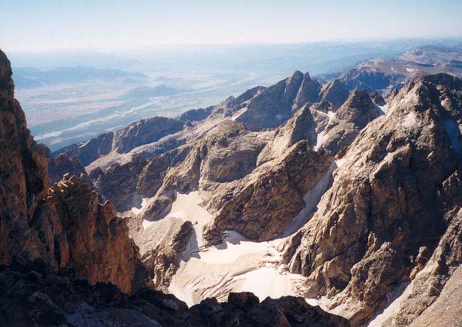
| Grand Teton from Jackson Hole | Lower Saddle from the Moraine |
Beyond the end of the developed trail there is brief section where you climb over and around a group of large boulders before reaching more level ground beside Garnet Creek. The trail then follows the stream for about 0.5mi to a high alpine meadow where there is a popular campground known as the Meadows (elevation 9400ft). Here, at the head of Garnet Canyon, you are near the treeline with mostly glacier and rock all around. Two steep valleys, the North and South Forks of Garnet Canyon, descend into the Meadows. Our route is up into the North Fork. From the Meadows, the trail switchbacks up a steep and partially wooded slope as it climbs around to the right of Spalding Falls. The water comes from the Middle Teton Glacier still out of sight high above you in the North Fork. Above Spalding Falls the trail crosses over the stream at a place where there is a camping area known as the Petzoldt Caves. The name refers to campsites dug out under some huge boulders. You pass the last trees on the route at an elevation of about 10000ft. Above the Caves, the trail switchbacks up a steep, barren talus slope that eventually crests at the top of a great moraine. Here the Middle Teton Glacier has deposited a great rough platform of rocks, forming a narrow hanging canyon bounded on the right and at the head by rock walls and on the left by the glacier. This rocky platform is the location of the camping area known as The Moraine, a series of small tent-sized clearings sprinkled over a wide area, each protected by camper-built rock walls that provide a little shelter from the frequent winds.
You should reach the bottom end of the Moraine camping area (elevation 10750ft) about 6hr and 6.2mi after the morning start. Braided trails lead up the 0.25mi length of this camping zone that terminates at the bottom of a steeper talus slope in the head of the canyon at an elevation of about 11000ft. We camped at the highest group of sites at the bottom of this talus slope and just to the left of the trail; one advantage of that location was the small glacier just above the site which provided a small but adequate supply of water.
 | 
| |
|---|---|---|
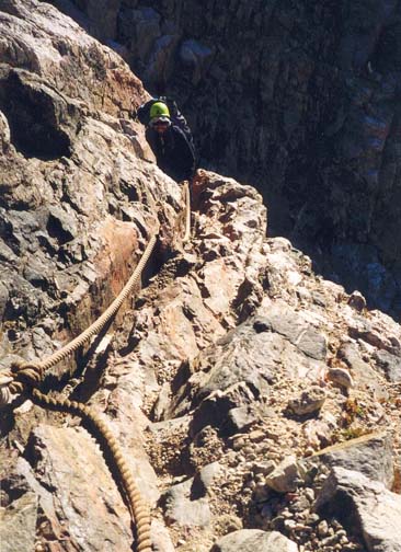
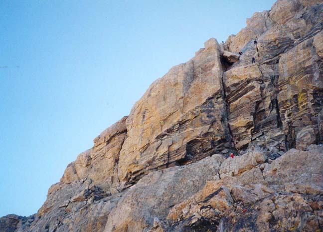
| Ascending the fixed rope | Looking up from Lower Saddle |
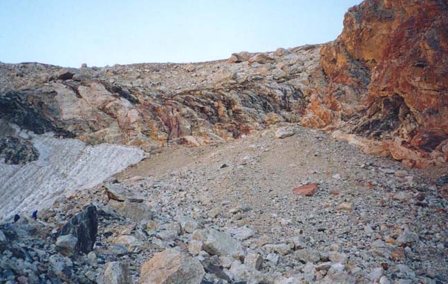
We slept longer than we had planned and after breakfast began hiking about 7.30am. From the site at top of Moraine camping area (11000ft), the trail climbed the steep talus slope toward the cliff in the head of the canyon. At the top of that talus slope, it is necessary to climb about 40ft up an easy cliff using a very thick fixed rope, many good footholds and an inclined slot. This first climbing challenge could readily be ascended without the fixed rope. From the top of rope climb (11450ft), the trail switchbacks up about 200ft to the broad Lower Saddle (11650ft) that lies between the Grand and Middle Tetons and is readily seen from the valley far below. You should reach the Lower Saddle (43o44.09'N 110o48.62'W) within about 30min from starting out. Here there is running glacial melt water to the left of the trail just before the apex of the saddle, the last water on the ascent. Two Exum Guide huts and a number of windswept campsites (protected by stone walls) also occupy the Lower Saddle. From it you get the first magnificient views west into Idaho. Below you to the west lies the broad South Fork of Cascade Canyon, another popular hiking route with a developed trail. The view to the south is dominated by the mass of the Middle Teton, clearly a very difficult and long technical climb from this starting point.
Looking north the trail proceeds northeastwards up the crest of the broad ridge toward the mass of the Grand Teton. Straight ahead you will clearly discern the broad horizontal band of black rock known as the Black Dyke that runs across the bottom of the mountain. When the trail up the ridge steepens, it proceeds straight up through the Black Dyke, directly toward a large cliff that blocks the route straight ahead. Here it is important not to veer left on one of the many braided trails but to continue straight up to the base of the cliff. Then turn left and follow the well-worn trail that proceeds around the foot of the cliff and into a talus-filled gully. Just about 50ft up this gully, after just one switchback, you will encounter the single navigational challenge on the ascent to the Upper Saddle. This challenge is known as the "Eye of the Needle" and we found the available diagrams and descriptions of dubious value here. Only after several errors did we recognize the correct (and quite simple) route as follows. After the trail arrives in the talus-filled gully and makes one switchback across it, look to the right and find a steep rock ledge that begins broad but narrows as it rounds a promontory above you on the right. Many folks proceed up this ledge (it had a cairn on it when we passed this way) and then find some technical challenges around the corner ahead. Do not ascend that ledge. Instead proceed about another 20ft up the talus-filled gully to a much less obvious ledge trail that proceeds right under an overhang to a bench, known as the "Eye of the Needle" bench that is about 90ft directly above the start of the broad lower ledge. (On the way back down the mountain we chose to rappel down about 90ft from the "Eye of the Needle" bench to the talus-filled gully.) Above the "Eye of the Needle" bench, the route to the Upper Saddle is fairly obvious. You proceed straight up a broad gully, staying to the right initially and then crossing over toward the left side for several hundred feet. Here there is a well-worn trail in the talus slope that switchbacks up and eventually reaches the Upper Saddle (43o44.47'N 110o48.31'W and elevation 13100ft).
 | 
| |
|---|---|---|
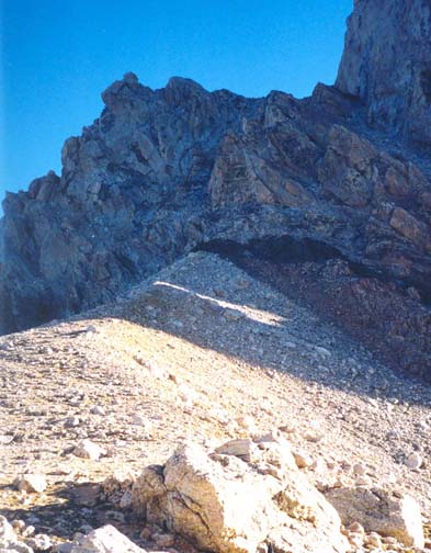
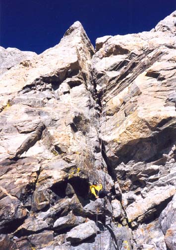
| View south from Upper Saddle | Summit block from Upper Saddle |
At the Upper Saddle you are treated to awesome views in both the southerly and, newly revealed, in the spectacular northerly direction. To the south you can now see all the Teton peaks at the southern end of the range and, in the distance, the city of Jackson. To the north you can see the 12928ft Mount Owen half hidden behind the mass of the Grand. And below you an almost vertical 5000ft drop into Cascade Canyon. That large canyon represents a major east/west slice through the Teton range, its waters filling Jenny Lake. Further northeast you can also see parts of Jackson Lake. Supplementing the awesome drop-offs to the north and south, is the massive cliff above you on the east, the vertical side of the summit block of the Grand Teton. Standing here it is hard to see how there could be any easy way to surmount that obstacle. Cliffs of over 100ft tower vertically overhead as far as you can see on both sides. And the drop-offs to both the left and the right are awe inspiring.
However, from the Upper Saddle a use-trail climbs up a short talus-covered ridge running up to the base of the cliff around the summit block and thence to a talus-covered platform at the bottom of rappel descent of the cliff. You should reach this readily recognized waypoint (elevation about 13200ft) about 3.5hr after the morning start. Here you will most likely encounter other groups descending from the summit block via either of the two, side-by-side rappel routes about which more later. From here the route is obvious. Off to the left is a narrow and narrowing ledge. This is the beginning of the Owen-Spalding route, the easiest way to the top from the Upper Saddle. Just about 30ft from the bottom of the 120ft rappel, you pass the bottom of a chimney called the Wittich Crack, and, 15ft beyond it, encounter the beginning of the first technical and constitutionally challenging part of the route, a series of very exposed obstacles on a narrow, horizontal ledge. The first of these obstacles is known as the Bellyroll and is formed by a large slab that has detached from the rock face. Roped up and belayed you must make your way around this slab by hanging onto its top edge and using the modest footholds on its steep outer face. The length of this manouver is only about 10ft and it would be easy were it not for the fact that the vertical drop-off below you is several thousand feet! Beyond the Bellyroll, you access a narrow but comfortable shelf that quickly narrows to a horizontal tube-like ledge known as The Crawl. You can either wiggle through The Crawl or, on a belay, transition around in the same way that you did the Bellyroll. Again the exposure is enormous. As the tube of The Crawl widens again, there is another, smaller detached slab similar to the Bellyroll and immediately after that you proceed into and up the deep and easy Double Chimney (5.3 at most) that allows a little relaxation by taking you away from the enormous exposure. After about 20ft of easy climbing you clamber out of the top of the Double Chimney onto a broad recessed platform where you can recover some equilibrium.
 | 
| |
|---|---|---|
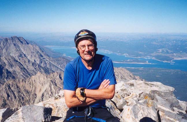
| On the summit of the Grand Teton | The 120ft rappel descent | |
(Photos by Doug Hart and Clancy Rowley) | ||
There are two ways to get from this platform to a long, broad and comfortable ledge that runs horizontally across the summit block about 50ft above where you are perched. The first is the obvious Owen Chimney that runs up from the back of the platform. The second is a series of angled ledges known as The Catwalk that proceed around to the right (south). The Catwalk is very exposed, especially the first 20ft around a small promontory. It is wise to set up a handline or belay for this first section using a permanently wedged nut (or other protection device) in a crack at the back of the platform. You proceed around the promontory and then climb about 6ft up onto a broader ledge where there is a convenient anchor point through a natural rock hole. Though exposed, you can then proceed about 150ft along the angled Catwalk to the afore-mentioned broad ledge at the point where the top of the 120ft rappel is located. This is a comfortable place to rest and prepare yourself for the easier final section of the climb to the summit.
From the rappel top proceed a short distance north along the broad ledge to the obviously climbable chimney know as Sargent's Chimney. If you are unsure about identifying the right chimney proceed further north along the broad ledge to where it ends in the much larger Great West Chimney and then backtrack to the smaller and climbable Sargent's Chimney. In the absence of ice, it is fairly easy and safe to free climb about 120ft up this chimney to a recognizable rappel point where you exit to the left onto another broad, horizontal ledge. Proceed around to the north for about 20ft to the first place where you can readily climb up from the ledge. Now you have started on the last section and the slopes mostly allow an easy scramble to the summit. Proceed in a northeast direction, making special note of your route to the summit so that you can comfortably retrace your steps on the way down. As you clamber up this last easy section veer somewhat to the left and you should access a use-trail that bypasses a 25ft slab and proceeds up to a final broad chimney. Climbing about 20ft up this chimney, you will find yourself on the 13770ft summit of the Grand Teton (43o44.48'N 110o48.16'W).
The time to reach the top depends very much on the time taken to negotiate the Bellyroll/Crawl section; a reasonable estimate of the hiking and climbing time for the ascent from the Moraine campground is 7hr.
On the descent, proceed back down to the top of Sargent's Chimney where there is a rappel anchor. Take advantage of this to rappel down at least 100ft since this is faster and safer than downclimbing. On a double-strand rappel even a 200ft rope will leave you 10ft from the bottom but that last piece is an easy downclimb. Then proceed around to the left to the top of the spectacular Owen-Spalding rappel that will take you down to the Upper Saddle area. There are actually two Owen-Spalding rappel routes side-by-side, one with one long rappel and one with two shorter rappels. For the long one you need either two ropes 120ft or longer for a double-strand rappel or one 120ft rope plus a 120ft recovery cord for a single-strand rappel. This is a spectacular, vertical descent; depending on the precise route you take from the anchor point you can have as much as 100ft of free rappel. The other, two-stage rappel route consists of two 70ft rappels. They are less frequently used but allow a double-strand descent with just one 160ft rope. That route is located just to the south of the long rappel route and the top anchor point is somewhat higher.
From the bottom of the Owen-Spalding rappel you make your way down the use-trail to the Upper Saddle and then down the talus slope toward the "Eye of the Needle" bench; here it will have been particularly useful to fix the location of this bench in your mind as you climbed up from it during the ascent. From the bench you can either proceed along the narrow ledge to the talus-filled gully or make the descent using a 90ft rappel. There are several large rocks that can be wrapped to provide the anchor for this rappel. From the talus-filled gully at the bottom proceed down the use-trail that first hugs the base of the cliff on the left until directly above the ridge running up from the Lower Saddle. The trail then descends down through the Black Dyke to the Lower Saddle which you should reach about 3hr after leaving the summit. You then veer left to descend via the fixed rope to the Moraine Camping Area. The time for the descent from the summit is about 3.5hr and the total hiking/climbing time from the Moraine to the summit and back is about 10.5hr.
On the third day, the descent from the Moraine to the Lupine Meadows
trailhead is quite straightforward. Starting out with full packs from
the camp sites at top of the Moraine camping area (11000ft),
it takes about 1hr to reach
the Petzoldt Caves, 1hr 40min to get to The Meadows and
5hr to reach
the Lupine Meadows trailhead (elevation 6732ft).
Last updated 8/28/01.
Christopher E. Brennen