ADVENTURE HIKES AND CANYONEERING
IN THE SOUTHWEST
© Christopher Earls Brennen

|
|---|

|
Hike B8. Grand Gulch
- Hiking time: 2 or 3 days
- Estimated hiking distance: 22.8 miles
- Elevation gain: 660 feet
- USGS Topo Map: Cedar Mesa North, Pollys Pasture, Kane Gulch
- Difficulties: None
- Special equipment: Water and a water filter
- Permit: Obtain permit from Kane Gulch Ranger Station
-
ACA Rating: 1A IV

Characteristics
Cedar Mesa is a beautiful, juniper and pinon pine forested flatland of thousands of square miles in the southeast corner of Utah. It is a remote and unpopulated land at an elevation of about 6500ft, high above the desert to the south. Over geological time, water runoff from this plateau carved great canyons through the soft sandstone of Cedar Mesa, and so its most attractive features lie below the elevation of the mesa itself, in the network of deep canyons that intersect the high plateau. Many (though not all) of these canyons join to form Grand Gulch, a majestic fissure that flows southwest, eventually emptying into the San Juan River which itself joins the Colorado some distance to the west.
What makes the canyons of Cedar Mesa so beautiful is the magnificient high altitude flora and fauna that embellish the sculpted sandstone gorges. The same fecundity attracted ancient man and so although, modern man only built paved roads through this land in the last 30 years, it was a very popular place for Native Americans for thousands of years. So popular that the canyons abound with the buildings and remains of the Anasazi culture, mostly constructed during the Pueblo periods from 700AD until they were abandoned shortly before 1300AD.
Cedar Mesa's twin attractions, magnificient scenery and largely unspoilt remains of an ancient and resourceful culture, have led to an explosion in visitors over the past decade. We feature it here because the hiking is still quite primitive and adventurous. Though there are many possible hikes within the Cedar Mesa or Grand Gulch area, we have choosen to feature one particular example, one of the most popular because of the interesting variety of Anasazi ruins that can be visited along the way. From the Kane Gulch Ranger Station you hike down Kane Gulch to where it joins Grand Gulch and then descend Grand Gulch to the intersection with Bullet Canyon. You then hike back up Bullet Canyon to the trailhead on the mesa at the top of that canyon. Thus the hike requires a car shuttle. Because the summers are very hot and the winter nights are very cold this is a hike best done in the spring or fall. It is a 23mi long, two or three day hike depending on how fast you travel and how much time you spend inspecting the ruins and enjoying the scenery.
Day hikes in the Grand Gulch Primitive Area require a permit that can be obtained at the trailheads. Permits for overnight hikes must be obtained in advance by phoning the BLM office in Monticello, Utah, at 435-587-1532. However, about half of the quota of permits are held for walk-ins. These are available at the Kane Gulch Ranger Station on a first-come, first served basis from 8.00am until noon on the day that you wish to start your hike.
Trailhead
Kane Gulch Ranger Station (37o31.54'N 109o53.75'W), operated by the Bureau of Land Management (BLM), is the key starting point for any overnight exploration of Cedar Mesa or the Grand Gulch National Primitive Area. It is located on Utah State Route 261, 4mi south of the junction with US Highway 95, about 37mi west of Blanding, Utah and about 35mi east of Hite, Utah where US 95 crosses Lake Powell. Alternatively, if you are driving up from the south along SR 261, you will have the pleasure and thrill of climbing about 1100ft up onto the Cedar Mesa via the Moki Dugway, a series of dirt road switchbacks that cut into the steep rock cliff that bounds the mesa on the south.
To leave the return vehicle at the Bullet Canyon trailhead, drive 7mi south from the Kane Gulch Ranger Station along SR 261. Turn right at 37o25.87'N 109o56.05'W onto County Road 251 (packed dirt) following the signs for the Bullet Canyon trailhead and drive 1.5mi to the well-marked trailhead (37o25.82'N 109o57.71'W). Leave the return vehicle here and return to the Kane Gulch Ranger Station. Park the other vehicle, cross the road and head west down the trail into Kane Gulch.
Hike
The author has planned to complete this hike in the near future. To date he has only explored the last 3mi in Bullet Canyon on a brief day hike. What follows are some pointers mostly gleaned from other accounts.
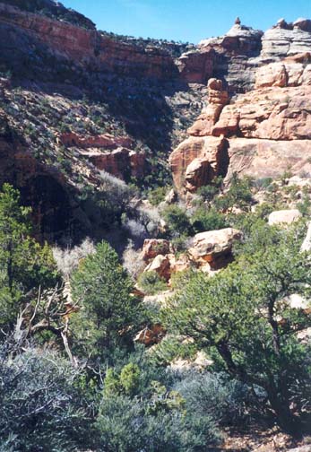 | 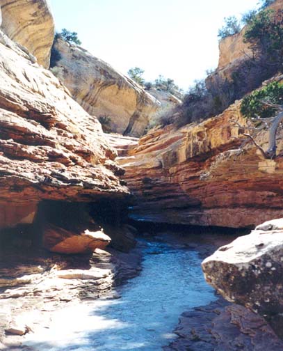
| |
|---|---|---|
| In Bullet Canyon | Stepped narrows in Bullet Canyon |
From the Kane Gulch Ranger Station (elevation 6420ft), cross the road and head west down the trail into Kane Gulch. The 4.0mi route to the junction of Kane and Grand Gulch drops about 600ft. At the junction (elevation 5820ft) you will find a nice campsite with much cottonwood shade and a cliff dwelling called Junction Ruin in a huge alcove on the right wall of the canyon. There is a spring 0.25mi downstream from the junction and within a mile of the junction you can also inspect Turkey Pen Ruin on the right at 4.7mi and Stimper Arch on the left at 5.0mi. Continuing down Grand Gulch you pass Fortress Canyon on the right at 5.6mi, Todie Canyon on the left at 7.2mi, a spring at 7.5mi, a pour-off at 8.8mi, Lion Tracks Spring at 9.6mi, Split Level Ruin (one of Grand Gulch's largest ruins) at 10.0mi, Coyote Canyon on the left at 12.8mi, the Thumb at 13.7mi, Shieks Canyon (much rock art) on the left at 14.2mi before arriving at 15.6mi at the junction with Bullet Canyon (37o26.74'N 110o2.59'W and elevation 5740ft). There is a spring at the junction and a good camping site.
About 2.2mi of easy hiking up Bullet Canyon, you will encounter another spring called Jailhouse Spring. On the left just 0.2mi further (and 18mi from the start) is the name-sake antiquity, Jailhouse Ruin, given that name because of the barred window. Across the canyon from Jailhouse Ruin is another good campsite. Another 0.3mi will bring you on the left to Perfect Kiva, the only undamaged ancient kiva ever discovered. It even had its roof in place (since replaced to withstand hikers!).
It is 4.5mi from Perfect Kiva to the end of the hike at Bullet Canyon trailhead. About 2.5mi from the end the canyon narrows and you encounter a boulder jam where the trail climbs around to the left using a prominent shelf on the left wall. Just a short distance upstream (about 1.5mi from the end) the streambed ascends steeply over bare slickrock, climbing 300ft. Near the top you fork right and continue to climb through a stepped narrows before the canyon flattens out again.
Here the canyon walls are less than 100ft
in height and you should watch for the ducked trail that climbs
the left wall to the mesa top. It is just a hundred yards across the mesa
to the Bullet Canyon trailhead
(37o25.82'N 109o57.71'W and
elevation 6400ft) and the return vehicle. The hike covers a
total of 22.8mi.
Last updated 4/1/02.
Christopher E. Brennen