ADVENTURE HIKES AND CANYONEERING
IN THE SOUTHWEST
© Christopher Earls Brennen

|
|---|

|
Hike F3. Bridge Mountain
- Hiking time: 6.5 hours
- Estimated hiking distance: 6.5 miles
- Elevation gain: 2400 feet
- USGS Topo Map: La Madre Spring
- Difficulties: Some modest, class 3 climbing challenges with large exposure in a few places
- Special equipment: Leather gloves recommended
-
ACA Rating: 2A III

Characteristics
Bridge Mountain (7003ft) is the highest peak in the Red Rock Canyon National Conservation Area just west of Las Vegas, Nevada. It is a naked block of white rock sitting above a maze of dramatic red and white canyons, forming the eastern edge of a great escarpment. The scenery is spectacular, stark and sheer slickrock with huge drop-offs in every direction. A narrow neck of slickrock joins the ridge to the west with the mass of Bridge Mountain and thereby allows one to reach the base of the mountain from the west. From afar that seems like the least of the problems, for the western face of Bridge Mountain consists of two substantial cliffs one above the other with a horizontal ledge in between. The lower cliff rising up from the neck appears unscalably vertical from a distance. Inspecting it from the escarpment ridge to the west, you can discern two vertical cracks or chimneys that might allow ascent for the skilled rock climber fully equipped with gear. In fact the left crack is readily ascended without gear but this is hard to believe until you get right over to it. In fact, the climb is Class 3 and can safely be accomplished without protection though the apparent exposure is intimidating. The climb up the lower cliff brings you to a lovely natural arch which can also be seen from the western ridge. Above the arch, the shelf contains a surprise, a hidden forest in the depression below the upper cliff. The upper cliff is readily climbed by means of a ledge that angles up from right to left and takes you to the summit ridge. The climb is fun and exhilerating; it provides breathtaking views of the maze of canyons around the mountain, of the flatland to the east with Las Vegas in plain view, and of the higher mountains to the northwest.
Trailhead
The trailhead is at the summit of a pass (Red Rock Summit at 36o7.85'N 115o32.00'W) traversed by a rough 4WD dirt road that can be accessed either from the northeast or the southwest. The southwest approach proceeds as follows. From Interstate 15 about 8mi south of Las Vegas, Nevada, take the Blue Diamond/Pahrump exit onto Highway 160 and drive west for 24mi to Lovell Canyon Road. Turn right, following the paved Lovell Canyon Road for 7.5mi where you should turn right onto a rough dirt road. At this turn off there is a large camping area across the road on the left. If you are driving a 2WD vehicle you should park here and proceed on foot. In a 4WD vehicle, turn right onto the dirt road (there is a sign indicating road 549) and, ignoring two left forks in the first 0.3mi, proceed through a gate (usually open) and shortly thereafter fork left where a faint track goes right. About 1.5mi from Lovell Canyon Road, you descend into a wash which you follow for another, very rough 1.5mi to the trailhead at Red Rock Summit (elevation 6450ft).
The alternative approach is from the northeast. Drive about 13mi west from Las Vegas along Charleston Boulevard (Highway 159) to the entrance to the Scenic Loop through the Red Rock Canyon National Conservation Area. (Or you can drive north from the Blue Diamond/Pahrump exit on Interstate 15 along Highway 160 and turn north on Highway 159 to the Scenic Loop entrance). Pay $5 to enter the Scenic Loop and follow it for 7.5mi to White Rock Picnic Area where you turn right and follow the rough 4WD dirt road known as the Rocky Gap Road for about 5mi to Red Rock Summit.
Though the Sierra Club guide opines that the southwest approach is preferable, the author found the northeast approach to be much less rough.
Hike
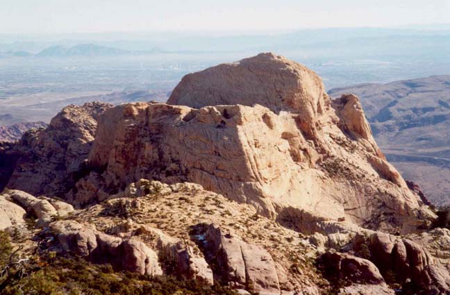
From the Red Rock Summit trailhead (36o7.85'N 115o32.00'W and elevation 6450ft), proceed east following the well-worn trail through sparse juniper forest for about 1mi. The trail climbs quite steeply to the crest of the dominant north/south ridge overlooking the canyons to the east. You should reach this ridgetop (36o7.92'N 115o31.27'W and elevation 7120ft) after about 40min. Once there, you are treated to a spectacular view of the Red Rock Canyon National Conservation area, a slickrock maze of interlocking canyons. Rising above these, its white rock striking in the morning sun, is the great block of Bridge Mountain. You should be able to discern the narrow neck of rock between Icecube Canyon and Pine Creek Canyon that leads to the base of the lower cliff around Bridge Mountain. From this vantage point it appears to be a very serious technical mountaineering task to ascend this cliff. Just to the left of the end of the neck are several vertical cracks or chimneys in the cliff and this adventure will ascend the left chimney. From the western ridge, that climb looks impossible and appears to have enormous exposure.
 | 
| |
|---|---|---|
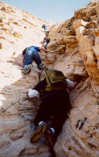
| Bridge Mountain from western ridge | Ascending the chimney |
After drinking in your first view of Bridge Mountain from the western ridge, you turn south and follow the trail along the crest, proceeding up and down and contouring west around a peak before climbing again to the ridgeline about 55min from the trailhead. At this point, the trail turns back north and begins descending toward the slickrock. The view below you to the east is a magnificent maze of vertical canyons that eventually merge and empty out onto the eastern floodplain far below you. At this point you are looking down into the tributaries of Pine Creek and, as you descend further you come to an overlook at 6630ft where there is a spectacular vertical drop-off of a thousand feet or more into Pine Creek Canyon. Just beyond the overlook you reach the slickrock where the trail only exists as a series of rock cairns or "ducks". Note that the entire route to the summit is marked by ducks and, in places, by two black, parallel lines painted on the rock. Initially the slickrock descent is easy going but further down there is one steep section with substantial exposure where the use-trail descends a series of short chimneys. Here it is wise to follow the ducked trail. This series of chimneys brings you down to the flatter slickrock of the narrow neck that allows access to the block of Bridge Mountain. On the south side of the neck there is a huge drop-off into Pine Creek Canyon; on the north side there is a smaller though still dramatic vertical drop into Icecube Canyon. The green of the trees in the forested bottom of this branch of Icecube makes a nice contrast with the red and white of the bare rock all around.
 | 
| |
|---|---|---|
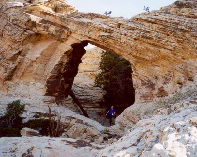
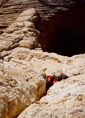
| The Natural Bridge | Descending the chimney |
You should reach the lowpoint on the neck (36o7.87'N 115o30.44'W and elevation 6200ft) about 1hr 50min after leaving the trailhead. From there, proceed up toward the base of the lower cliff, angling left so that you are just above the northern drop-off. As you ascend the slickrock here, it will become clear that the crack or chimney on the left is not as steep as it appeared from further away (in contrast, a crack further right is, indeed, vertical). Most hikers will want to ascend by staying in the crack itself. It provides easy climbing with little apparent exposure. Some may choose to ascend to the right of the crack where the face is replete with good hand and footholds but the exposure is more intimidating. After about 150ft you will come to a point where there is a broad, flat ledge on the left. Leave the crack here, and proceed about 15ft to the left where a wider gully climbs to the top of the lower cliff. This leads directly to the natural bridge for which the mountain is named. You should reach the bridge (36o7.99'N 115o30.23'W and elevation 6580ft) about 2hr 30min from the start.
After passing under the bridge, climb the steep rock slope on the left to get to the large bench that cuts across the whole west face of the mountain. A depression in the interior part of this shelf hides the trees of the hidden forest. Turn right and head for the saddle at the south end of the forest. At this saddle the drop-off into Pine Creek Canyon is enormous. From there a series of slabs and ledges angle south across the upper cliff and climb to the summit ridge. Once you reach that ridge, make a mental note of where the ledge emerged for it is harder to locate it on the way down. An easy stroll along the summit ridge will take you to the peak (elevation 7003ft) at 36o7.93'N 115o30.10'W. You should reach the summit about 3hr 10min from the start.
The view from the peak is breathtaking. To the east the flat desert stretches off into the distance to Las Vegas and beyond. To the northeast you will see the striking bands of red rock that gave the park its name. All around below you, a maze of sheer-walled canyons that provide an off-trail hiking paradise. To the south one particular fork of Pine Creek stands out, featuring a glinting stream and several large waterfalls. That fork begins at a saddle west of Rainbow Mountain, the prominant peak south of Bridge Mountain.
The return trip follows the same route in reverse and takes about the
same length of time. The climb from the
low point on the neck to the western ridgeline is, perhaps, the most
demanding part of the hike but it allows marvellous afternoon views of
Bridge Mountain and the canyon maze.
Last updated 12/10/01.
Christopher E. Brennen