ADVENTURE HIKES AND CANYONEERING
IN THE SOUTHWEST
© Christopher Earls Brennen

|
|---|

|
Hike J2. Mount Whitney
- Hiking time: 4 days
- Estimated hiking distance: 43.5 miles
- Elevation gain: 10800 feet
- Topo Map: Mount Whitney topographical map
- Difficulties: Possible altitude effects
- Special equipment: None
-
ACA Rating: 2A VI

Characteristics
This four day hike takes you through some of the magnificient High Sierra landscape culminating in an ascent of Mount Whitney, at 14496ft the highest point in the contiguous United States. Most hikers who attempt Whitney do so by the direct route from Whitney Portal. The result of this is that the trail from there is so crowded as to be unpleasant. Moreover, it is difficult to obtain a permit to camp overnight on that route and, even if you are lucky in this respect the campground at Trail Camp is crowded and unattractive. This hike avoids all that by accessing the high country using the Shepherd Pass trail north of Mount Whitney. It is much easier to obtain a permit for this route. And the three days spent approaching Whitney by this route not only treat you to some marvellous scenery but also allow acclimatization so that the ascent of Whitney will be made in much greater comfort.
Though you should call ahead to inquire about a wilderness permit, you may be able, like us, to obtain it from the Mt. Whitney Ranger Station in Lone Pine on your way to the trailhead. A limited number of permits are issued each day for entry to the wilderness through each of the High Sierra trailheads. Permits for entry at Whitney Portal must be obtained many months in advance but we had no difficulty obtaining our permit for the Symmes Creek trailhead to the Shepherd Pass trail on the day before our hike.
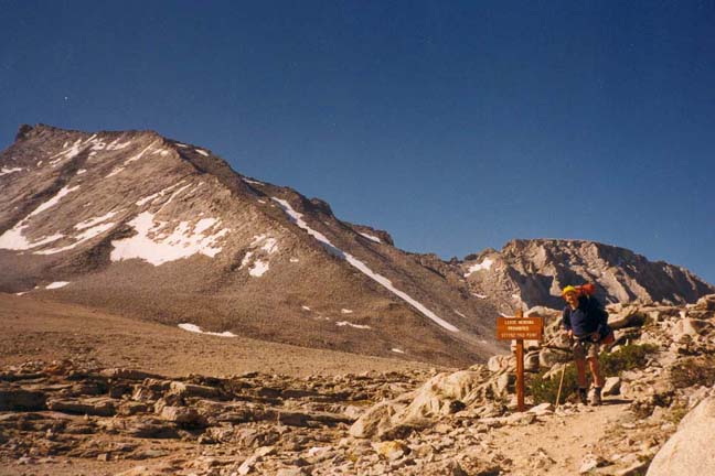
Trailhead
This hike requires a car shuttle beginning in Lone Pine on US 395 to the east of the high line of the Sierra Nevada mountain range. After obtaining your permit, maps and other information from the Mt. Whitney Ranger Station in Lone Pine, drive up to Whitney Portal and leave one vehicle in the parking lot in order to allow you to exit the wilderness there. Then drive back to Lone Pine and north on US 395. In the center of Independence turn west and proceed 4.5mi along Onion Valley Road to Foothill Road where you turn left. After 1.3mi you fork right and pass an old corral on the left. After about 0.5mi fork right and then twice more. This accesses a sandy road that contours north into the Symmes Creek valley and arrives at a large parking area (36o43.64'N 118o16.73'W and elevation 6000 ft) where the Shepherd Pass trail starts. It is a good idea to camp here and get an early start the next morning.
Hike
The Shepherd Pass trail is a long and, at times, arduous climb of about 6000 ft. It begins with a series of switchbacks that ascend to a saddle at 9000 ft between the Symmes and Shepherd creek valleys. This saddle provides the first of many truly exhilerating experiences on the trip for, quite suddenly, there unfolds a breathtaking panorama of the 14375 ft Mount Williamson and the dramatic cliffs that surround it. The memory of this magnificence lingers long after one leaves the saddle and begins a brief descent into the valley of Shepherd Creek before the trail resumes its ascent up that valley. There you encounter several stream crossings and water sources just below Mahogany Flats, a good place for lunch.
Resuming the climb, you switchback up to and over a very large moraine blocking the valley. This can be exhausting especially on a hot summer afternoon and while you are still adjusting to the altitude. Finally you enter the forest on top of the moraine and shortly thereafter arrive at Anvil Camp (36o41.51'N 118o19.61'W), 7mi from Symmes Creek trailhead. A very pleasant stream flows through the campground and this is a good place to camp at the end of a hard first day. But do not camp near the stream unless you enjoy the attention of the ubiquitous mosquitoes.
 | 
| |
|---|---|---|
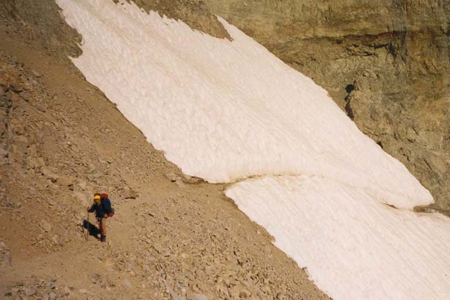
| Climbing toward Shepherd Pass | Shepherd Pass |
Resuming your hike the next morning, the views are magnificent as you climb through increasingly rugged and rocky terrain toward the 12050 ft Shepherd Pass. The trail is well-ducked and should guide you to the last part of the climb up a quite dramatic chimney somewhat to the left side of the ring of cliffs at the head of the bowl. The climb up the chimney involves short switchbacks. As you emerge from the top you contour to the left and traverse a small snow field before reaching the top of Shepherd Pass (36o40.34'N 118o20.71'W), 9.5mi from the Symmes Creek trailhead. The view of the High Sierra that opens up as you reach this summit is awe-inspiring. The mass of 14018 ft Mount Tyndall lies to the south; this peak is named for the English scientist who first explained why the sky is blue. The northern skyline consists of the angular outline of Diamond Mesa. Off to the west are the gently sloping meadows where Tyndall Creek begins and, in the distance, a marvellous panorama of Sierra peaks. Shepherd Pass also marks the entrance to Sequoia National Park and, because of this, several posted signs greet you at the summit. One, in particular, I found puzzling. It read ``No loose herding beyond this point''. ``Loose herding'' being undefined I was not at all sure how I could avoid an inadvertent transgression!
It is an easy walk down the gently sloping trail toward the junction with the John Muir trail near Tyndall Creek (36o38.35'N 118o23.27'W) at an elevation 10920ft and 14mi from the Symmes Creek trailhead. You enter the woods at the point where several trails converge near the Tyndall Creek camping area. Here you may wish to make camp for the second night though there are also good wilderness sites further south beside the John Muir trail. I enjoyed a campsite just to the east of the John Muir Trail a short distance south of the last Tyndall Creek river crossing. A beautiful row of small lakes lay just to the east.
The Muir trail south of Tyndall Creek travels due south through beautiful, mostly wooded country highlighted by many magnificient views of the surrounding mountains. You climb gently onto the broad Bighorn Plateau (2mi from the Tyndall Creek) marked by a small lake a few hundred yards to the right of the trail. For the next seven or eight miles you do not gain or lose much altitude but drop down into and climb back out of the small valleys of Wright Creek (5mi from the Tyndall Creek) and then Wallace Creek (6mi from the Tyndall Creek). As you approach Crabtree Meadow (36o33.56'N 118o21.55'W), you take the left fork through a tall pine forest as the Muir trail turns eastward and begins to ascend the valley of Whitney Creek. About 24mi from the start you pass the Crabtree Patrol Cabin (elevation 10700ft) and then proceed up a lovely wooded valley beside the inviting Whitney Creek eventually reaching the picturesque Timberline Lake (elevation 11080ft and 26.5mi from the Symmes Creek trailhead). This is a delightful place to stop, rest and perhaps fish. As you pause, take a moment to examine the massive bulk of Mount Whitney, looming above you, and the almost sheer cliff that extends south from the summit. The map tells you that the trail climbs this daunting cliff, though it is difficult to visualize that possibility from this vantage point. Just beyond Timberline Lake the trail climbs above the tree line and up to the larger Guitar Lake immediately below the mass of Mount Whitney. There are good camping sites around the shores of Guitar Lake and this would be a comfortable place to spend the third night. Guitar Lake is 27.5mi from the Symmes Creek trailhead at an altitude of about 11450 ft.
The trail beyond Guitar Lake climbs through steeper and steeper rock-strewn terrain as it approaches the almost vertical wall of rock on the west side of Mount Whitney. It then begins a series of switchbacks that, despite earlier doubt, do indeed climb the necessary 2000 ft to the top of the rock wall. There, at an altitude of 13500 ft and 30.5mi from the start, you arrive at the junction with the busy trail that ascends Mount Whitney from Whitney Portal. It is a good idea to leave your pack at this junction, known as Trail Crest (36o33.64'N 118o17.58'W), and climb the remaining 1000 ft and 2.5mi to the summit of Mount Whitney with just a waterbottle and a warm jacket. Along this last section of trail you will encounter many who are making the pilgrimage from Whitney Portal to the highest point in the contiguous United States. Many will have climbed to this altitude too quickly, and so you will see quite a few in considerable discomfort, and some who have decided to try and sleep it off among the rocks beside the trail. Most will clearly be laboring compared with you, a clear demonstration of the advantage of several days of acclimatization.
 | 
| |
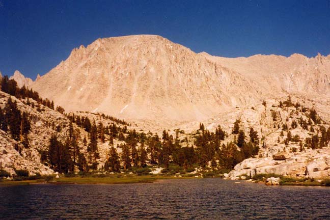
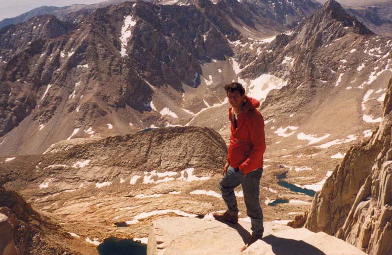
|---|---|---|
| Whitney from Timberline Lake | Looking south from the summit |
The trail from Trail Crest to the 14496 ft summit of Mount Whitney proceeds along a ridge, the route having been cut into the cliffs on the western side of the ridge. This part of the trail is quite spectacular. At intervals there are breaks in the ridge that form windows through to the other, eastern side and provide dramatically framed views of Owens Valley some 10000 ft below. The last leg of the climb through a field of rocks seems endless until, suddenly, you surmount the last rise and there is the summit (36o34.72'N 118o17.55'W) and the low stone warming-hut built as a refuge against the violent storms that can occur almost without warning on these mountains. And so you arrive at the highest point in the contiguous United States having travelled 33mi from the Symmes Creek trailhead. The view east from Mount Whitney is unforgettable. The immensity of the cliffs and the magnitude of the height are overwhelming. It is almost more than the mind can take in, enormous and brutal.
Soon it is time to begin the descent. The mood is usually subdued, as
you descend to Trail Crest and collect your pack.
There you take the route to Whitney Portal that begins
with a series of 97 switchbacks down the most
immense talus and rock slope. Even in summer, ice can make parts of this
descent treacherous so proceed with care. At the base of this descent is
the crowded campground that many use while climbing the direct route
from Whitney Portal. Below this the trail proceeds
down a steep valley often alongside a pleasant small stream and the arrives
at Mirror Lake. By this time, fatigue will begin to grow and the
last few miles to Whitney Portal may seem endless. Finally you arrive
at the Whitney Portal parking lot
(36o35.23'N 118o14.41'W),
at an elevation of 8360ft and having
hiked 43.5mi from the start at the Symmes Creek trailhead.
Hopefully you will locate the return vehicle without difficulty and then
retrace your drive back to the Symmes Creek trailhead to collect the other
car.
Last updated 9/9/99.
Christopher E. Brennen