ADVENTURE HIKES AND CANYONEERING
IN THE SAN GABRIELS
© Christopher Earls Brennen

|
|---|

|
Hike G10. Stoddard Canyon
- Hiking time: 6.5 hours
- Estimated hiking distance: 4.7 miles
- Elevation gain: 2340 feet
- USGS Topo Maps: Mt. Baldy
- Difficulties: At least two rappels of 100ft and 40ft
- Special equipment: Rappelling equipment for a 100ft descent along with 20ft of webbing and a rappel ring; a helmet is highly recommended
-
ACA Rating: 3A III

Characteristics
Stoddard Canyon parallels the much larger San Antonio Canyon (Baldy Canyon) and joins it just above the entrance to the latter. The head of the canyon is fairly readily accessed from the dirt surfaced Barrett Stoddard road. The descent provides a moderate adventure hike that is notable for two reasons. The upper reaches are characterized by numerous large and luxuriant ferns that give the canyon a tropical flavor. The lower reaches contain one section of narrows that represents the only major obstacles on this hike, namely two sets of waterfalls. The second of these can be easily bypassed but the first set requires two rappels, one of 100ft and the other of 40ft. The waterfalls are lovely and more than repay the effort to reach them.
Trailhead
Two vehicles are required for this one way hike. Drive up the Mt. Baldy road past the San Antonio Dam and turn left on Mountain Avenue. This descends to and crosses the San Antonio Wash, passes the Forest Service Station and turns south. About 0.6mi from the road junction you will notice a dirt parking area on the left, located just before the bridge over the Stoddard Canyon Wash. You may also notice a trail sign just beyond the dirt parking area. Park one vehicle here (34o10.35'N 117o40.44'W, elevation 2440ft) and then backtrack in the other vehicle to the previously mentioned road junction. Turn right and continue north up the Mount Baldy road. About 4.2mi from the Stoddard Canyon exit and just after passing over the Hog Back you will come to the turn-off to the Barrett Stoddard Road, a dirt track that branches off to the right. There are a number of roads here but you want the rough dirt road that descends to and crosses the wash while travelling in a downstream direction. It then climbs the opposite wall of the canyon before turning in toward a wooded recess in Barrett Canyon. About 0.8mi from the main road and after passing several houses in the woods you will come to a closed gate across the road (34o13.04'N 117o39.64'W, elevation 3920ft). Park near here in a way that does not impede local residents. If you choose not to drive up this rough dirt road but rather to park near the main road, it will add about 0.8mi to your hike.
Hike
Passing through the gate (34o13.04'N 117o39.64'W, elevation 3920ft), continue on up the Barrett Stoddard Road as it climbs along the side of San Antonio Canyon, high above the highway. After 45min or 1.75mi, a 4450ft saddle is reached and, traversing this saddle, you pass out of San Antonio Canyon and into the head of Stoddard Canyon. From this saddle, the trail to Stoddard Peak (4624ft) branches off to the right but we stay on the dirt road. The relatively flat area just after the saddle is known as Stoddard Flat. A few hundred yards beyond this you should pause to look down into the brushy gulch that is the start of Stoddard Canyon. While you could drop into the canyon here, I recommend that you continue on along the road to a point about 0.5mi from the saddle. There, just before a prominent rocky outcropping (at 34o11.90'N 117o39.49'W, an elevation of 4280ft and 1hr from the start), a steep and boulder-strewn wash crosses the road and descends into the main canyon. Water often flows in this wash. More important, it provides a slightly less brushy means of dropping into the canyon. As you descend you will know you are on the right route when you pass the skeletons of two vehicles, one an old Toyota Landcruiser.
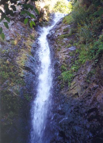 | 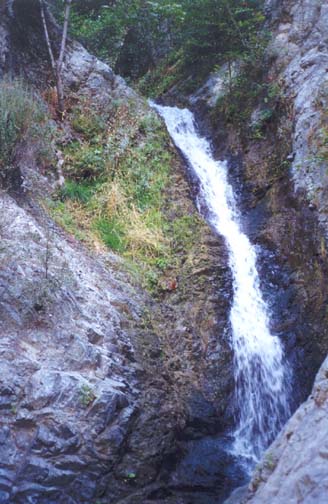
| |
|---|---|---|
| High falls in Stoddard Canyon | Second set of falls |
This first part of the off-trail route is slow going because it entails much bushwhacking. But these upper reaches are quite beautiful in places with large verdant ferns and a year-long stream. Soon the bottom gradient levels out, the canyon becomes more open and wooded and the going becomes easier and faster. Hopefully you will take time to enjoy this lovely, gentle canyon. About 2hr 30min from the trailhead and at an elevation of 3440ft a large gully enters from the left but this is not readily identifiable on the topo map. A little further downstream, the canyon bottom becomes more overgrown for a brief stretch and a section with many brambles is particularly nasty. Near here you will discern the substantial mass of the 4198ft Frankish Peak directly ahead. Shortly thereafter, the canyon turns west. At 3hr 30min from the trailhead and at an elevation of 3080ft another large gully enters from the left. This is the fork on the topo map that descends from the saddle between Stoddard and Cucamonga Canyons (and could potentially be used to access Stoddard Canyon from the 4WD road that climbs up from Cucamonga Canyon to Frankish Peak).
About 25min beyond this junction, the canyon narrows markedly and you suddenly arrive at the first of the big waterfalls in Stoddard Canyon (34o10.76'N 117o39.78'W, elevation 2980ft). This is a dramatic drop into a wooded abyss; from above it is very difficult to see the bottom and gauge the height of the drop. A narrow ledge trail leads around the right corner above the falls but, a few yards around the corner, the trail becomes quite dangerous and unstable. We did not proceed further but set anchors around two sturdy bushes above the trail for the purpose of descent at this point. An alternative would be to continue further along the hazardous trail (best done by roping into our anchors to provide protection) to where several old ropes are hanging. Descending there may avoid some of the dangers ahead.
From the location of our anchors, the height of the descent cannot be judged since the bottom is not visible. In fact it is a 100ft descent. The rappel itself is quite straightforward and dry but the rock about 20ft from the top is fractured and unstable and creates a serious danger from falling rocks. For this reason, a helmet is strongly recommended. But, as you descend, take time to enjoy the falls and the watery grotto they have created. At the bottom a small ledge beside a beautiful circular pool allows you to pause and unhook from the rappel. However, because of the danger from falling rock, you should cross to the other side of the 3ft deep pool before pulling down the rope.
The water from the pool immediately flows down another falls and this second step requires a 40ft rappel using as anchor one of the trees on the left side of the pool. The rappel is a little awkward in that you will want to stay to the left to avoid the waterfall and this risks a pendulum into the falls. We reached the bottom of this two-stage waterfall a little over 5hr from the trailhead.
About 15min downstream, you arrive at an abrupt left turn into a rocky chute that is readily descended and leads to the top of the second set of falls in Stoddard Canyon. This consists of two or three waterfalls and could be directly descended. The first stage is a 35ft drop into a deep pool; a lone tree some distance above and behind the lip of the falls is the only readily available anchor. But, there is a way around this set of waterfalls and we took advantage of this bypass. It begins at the abrupt left turn at the top of the chute. Directly ahead of this turn you will have noted a notch about 12ft above the canyon bottom. Climbing up to this notch, you will come to a rocky groove that descends about 150ft to the canyon bottom below the waterfalls. It is reasonably safe to free climb down this groove though you can also sling a rope around one of several bushes on the left if you are uncomfortable. The bottom of the groove is at an elevation of 2760ft and about 5hr 35min from the trailhead. After the descent you may wish to make your way a short distance upstream to the bottom of the falls before continuing downstream.
There are no more major obstacles in Stoddard Canyon. About
10min downstream of the groove a large gully enters from the left
and a well-worn trail leads downstream from this junction to the roadway
(34o10.35'N 117o40.44'W,
elevation 2440ft) after a 35min hike. The total duration of the
hike is about 6.5hr.
Last updated 7/30/99.
Christopher E. Brennen