ADVENTURE HIKES AND CANYONEERING
IN THE SAN GABRIELS
© Christopher Earls Brennen

|
|---|

|
Hike C3. Royal Gorge
- Hiking time: 6 hours
- Estimated hiking distance: 2 miles through gorge, 9 miles to and from Angeles Crest Highway
- Elevation gain: 2340 feet
- USGS Topo Maps: Pasadena, Condor Peak
- Difficulties: One rockface traverse around waterfall
- Special equipment: 20ft webbing
-
ACA Rating: 2A III

Characteristics
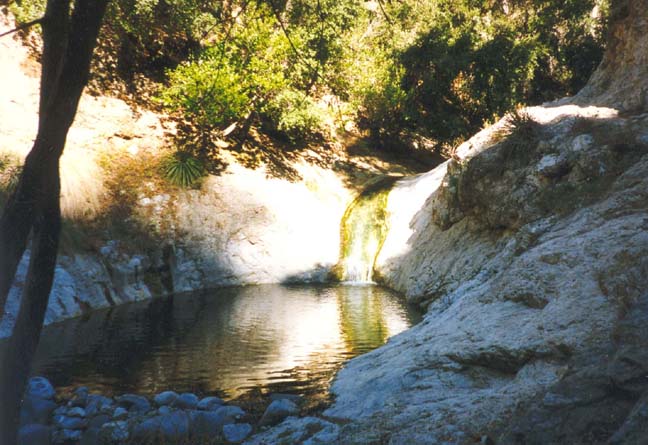
The Royal Gorge is a pleasant and wooded canyon that offers a fairly easy adventure hike. There is only one significant obstacle to overcome in traversing it, an attractive waterfall about 10ft high that empties into a large pool. This makes for a very pleasant swim during the summer months.
Access
Apart from the one waterfall, the main problem with this adventure hike is access. Probably, the most convenient strategy is to hike down to the Gorge from the Angeles Crest Highway (elevation 3560ft) and Switzer Picnic Area (elevation 3300ft). You hike downstream to the old campground known as Commodore Switzer (at 34o15.53'N 118o9.27'W and elevation 2910ft) and take the trail that climbs the left side of the canyon to bypass Switzer Falls. After passing high above Switzer Falls you will come to a trail junction (34o15.41'N 118o9.22'W and elevation 2990ft) where you fork left, descend into the canyon again and follow the Bear Creek trail to the mouth of Bear Canyon (34o15.06'N 118o8.99'W and elevation 2600ft), a distance of 2.7mi from the highway. Here you leave the trail and proceed downstream, entering the Gorge.
After the transit of the Gorge, you can return to the start using the main trail (11W14) through Long Canyon from the Arroyo Seco back to Switzer Camp. This route requires recognition of the junction of the Royal Gorge with the maintained trail at the end of the off-trail section of the hike, namely the point where Long Canyon joins the Arroyo Seco (34o15.11'N 118o10.60'W and elevation 1980ft). We refer to this point as the ``lower end of the Royal Gorge'' (note that it is just north of the southern edge of the Condor Peak topo map). Perhaps the best clue that this junction is near is the high thin waterfall dropping straight down into a canyon pool on the right as you approach the end of the hike through the Royal Gorge. The trail back to Switzer Camp traverses back up the side of the canyon and across the top of this waterfall as it enters Long Canyon. From the lower end of the gorge, the distance back to the Angeles Crest Highway through Long Canyon and Switzer Camp is 4.4mi.
Another possible strategy is to set up a long car shuttle and to continue on downstream through Oakwilde Campground and the lower Arroyo Seco to Altadena. It is 8mi from the lower end of the Royal Gorge to the parking area at the end of Ventura Drive in Altadena (34o11.64'N 118o10.08'W and elevation 1160ft). Such an itinerary could either be hiked or biked. In the latter case, you could ride mountain bikes down from the Angeles Crest Highway to the lower end of the Gorge and then hike a loop through the Gorge and back down the trail again to the bikes. The advantage of this is that the lower stretch of the Arroyo Seco can be covered much faster on a bike than on foot. On one such outing we set off from the Angeles Crest Highway about 8.30am and reached Altadena at 4.30pm. If you choose to use a car shuttle with this strategy then the preferred parking place in Altadena is not the end of Altadena Drive as suggested in some books, but the larger parking area overlooking the Arroyo Seco at the end of Ventura Drive and just after that street turns south. The main trail (road) into and out of the Arroyo Seco emerges here.
Hike
The upper end of the Royal Gorge is reached from Commodore Switzer (34o15.53'N 118o9.27'W, elevation 2910ft and 1.2mi downstream from Switzer Picnic Area) by taking the trail that climbs the west wall of the canyon in order to circumvent Switzer Falls. About 0.2mi along this trail and near its summit the trail divides (34o15.41'N 118o9.22'W and elevation 2910ft). The right fork (11W14) takes you down Long Canyon to the lower end of the Royal Gorge. The left fork (12W08) climbs down into the main canyon again. We note that, once the canyon bottom is reached, you can hike upstream about 0.3mi to the pool at the bottom of Switzer Falls, though, along the way, a small waterfall must be negotiated by climbing along the rock on the right hand side.
 | 
| |
|---|---|---|
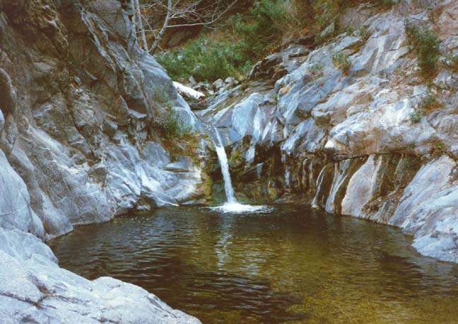
| Cascades near Bear Creek | Pool and falls in Royal Gorge |
To reach the upper end of the Royal Gorge you proceed downstream from the point where the trail reaches the canyon bottom. The trail (12W08) passes some tranquil pools and small falls and continues on down the canyon for about 0.7mi to the point where Bear Creek joins the Arroyo Seco (at 34o15.06'N 118o8.99'W and elevation 2600ft). It is appropriate to define this junction with Bear Creek as the upper end of the Royal Gorge. Note that it takes just about 30min to hike the 1mi from the point high on the canyon wall where the trail forks to the junction with Bear Creek. The maintained trail then proceeds up Bear Creek; but we leave the trail and continue downstream into the Royal Gorge.
The upper section of the Royal Gorge is a verdant canyon that is fairly easy hiking though with many stream crossings and only a faint use-trail. The walls increase in height but the canyon remains broad with a number of stream-side meadows and tree-covered benches. Here, in the cool depths where water runs year round, the trees flourish. As you progress, the canyon winds back and forth so that some sections see much more sun than others. Consequently, the flora changes with each bend. There are some sections with desert-like foliage and numerous yuccas; other, cooler sections are populated with numerous alders. It is a pleasant hike that can differ considerably with the season and is probably best seen in the spring, fall or winter. However, like all these canyon hikes it is not wise to try them after rain when the risk of a flash flood is considerable.
About 1hr downstream from the beginning of the Royal Gorge you will encounter the only significant obstacle in the Gorge, a waterfall that is not particularly high (about 10ft) but falls directly into a large and deep pool (about 10ft deep) contained between steep rock sidewalls. You can circumvent this in several ways. You can traverse the lefthand rockface using a series of natural footholds and handholds in the rock. This is easier than it appears at first sight. Webbing has been strung along this rockface and could be used in an emergency but should not be trusted. The alternative is to swim across the pool by first downclimbing or rappelling to the right of the falls where there are a number of footholds.
From the bottom of the falls to the lower end of the Royal Gorge (34o15.11'N 118o10.60'W and elevation 1980ft) is a hike of 1hr 20min. The only other obstacles worth specific mention are just a short distance downstream of the falls where the canyon is quite narrow and the stream spans the entire width. Here, you may have to wade. Note that this section can present a more substantial obstacle when the water in the stream is high. Our hike was made in January of 1996 before significant amounts of rain had fallen that year.
In summary, it takes about 2hrs 40min to traverse the
the Royal Gorge. About 15min from the bottom is a place where the canyon
makes a 180 degree bend from due west to due east. This bend
can be clearly identified on the topo map. Once you reach this point
you have almost completed the transit of the Royal Gorge.
Last updated 7/30/99.
Christopher E. Brennen