ADVENTURES AROUND THE WORLD
© Christopher Earls Brennen
Hike F9. Tory Island
- Hiking time: 2.5 hours
-
Estimated hiking distance: 3 miles

- Elevation gain: 250 feet
- Topo Map: Sheet 1 (North Donegal), 1:126720 Series, Ordnance Survey of Ireland
- Permit: None
Characteristics
There is nowhere quite like Tory Island, a bleak and treeless landscape much of which has been scraped down to the bare rock to provide soil for the fields and turf for the fireplaces. It is a place out of time, a hundred years or more, and it struggles to survive the present. Exposed to the fierce Atlantic off the northwest corner of Ireland, sea travel over the nine miles to the mainland is dangerous in the best of weather and lethal the rest of the year. Many of the tiny houses are now empty, abandoned by families fleeing to a better life. At one time the island population exceeded 500; today it is less than 100. No wonder that those that remain are a fierce, tough and independent people. They choose their own ``King of Tory'' to help represent their needs and aspirations (other islands of Ireland used to do the same but elsewhere the practice has disappeared). For the past 20yrs, Patsy Dan Rodgers has been the ``King of Tory'' and an active and vigorous representative for the Island people. He greets every tourist as they step off the ferry, lobbies for the needs of the islanders and has initiated and promoted a school of island painting that exhibits and sells its art work around the world. I had the great privilege of spending a couple of evenings with him in the local bar that is part of the Harbour View Hotel and much enjoyed not only his company but the music of his accordion.
| 
| |
|---|---|---|
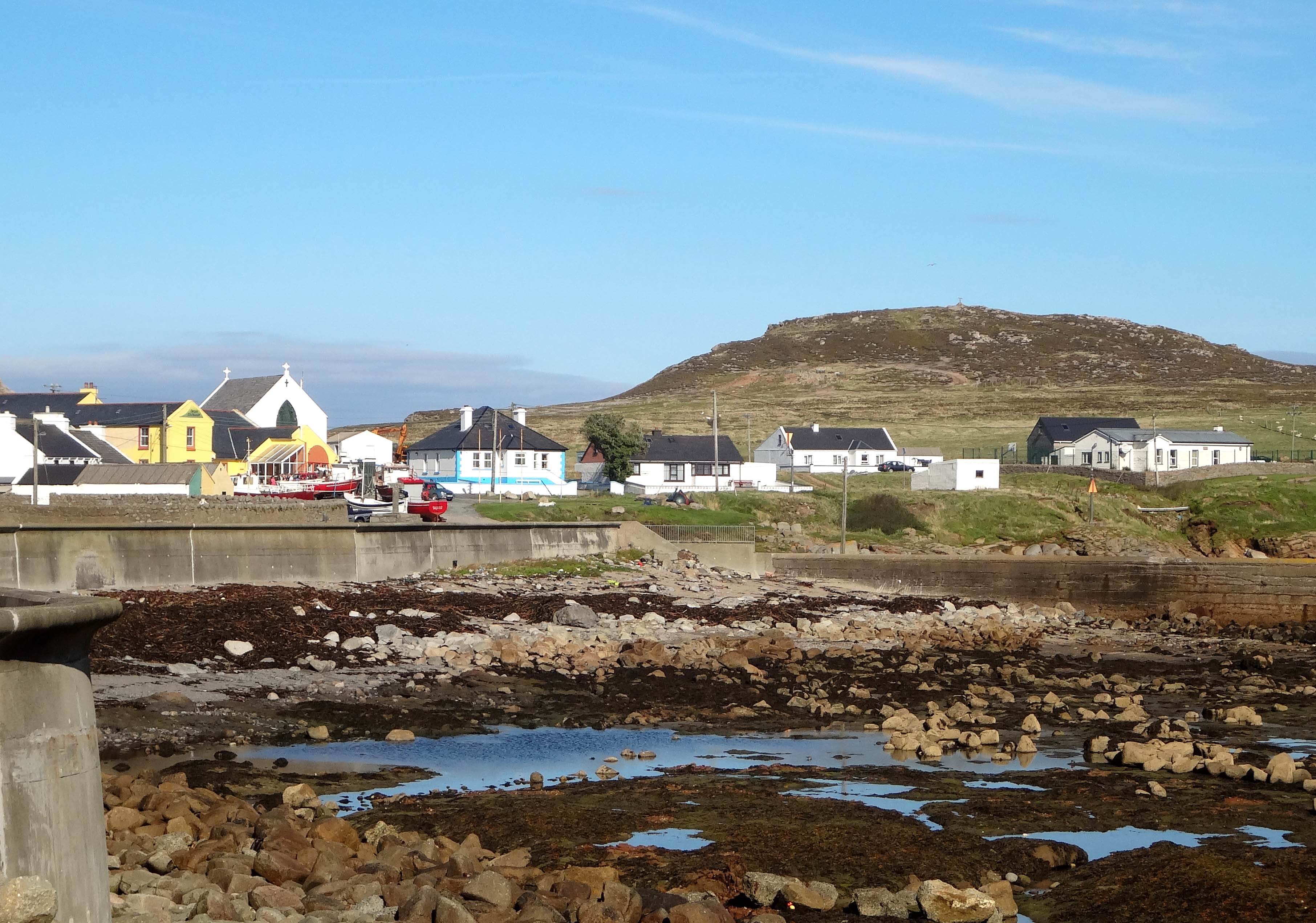
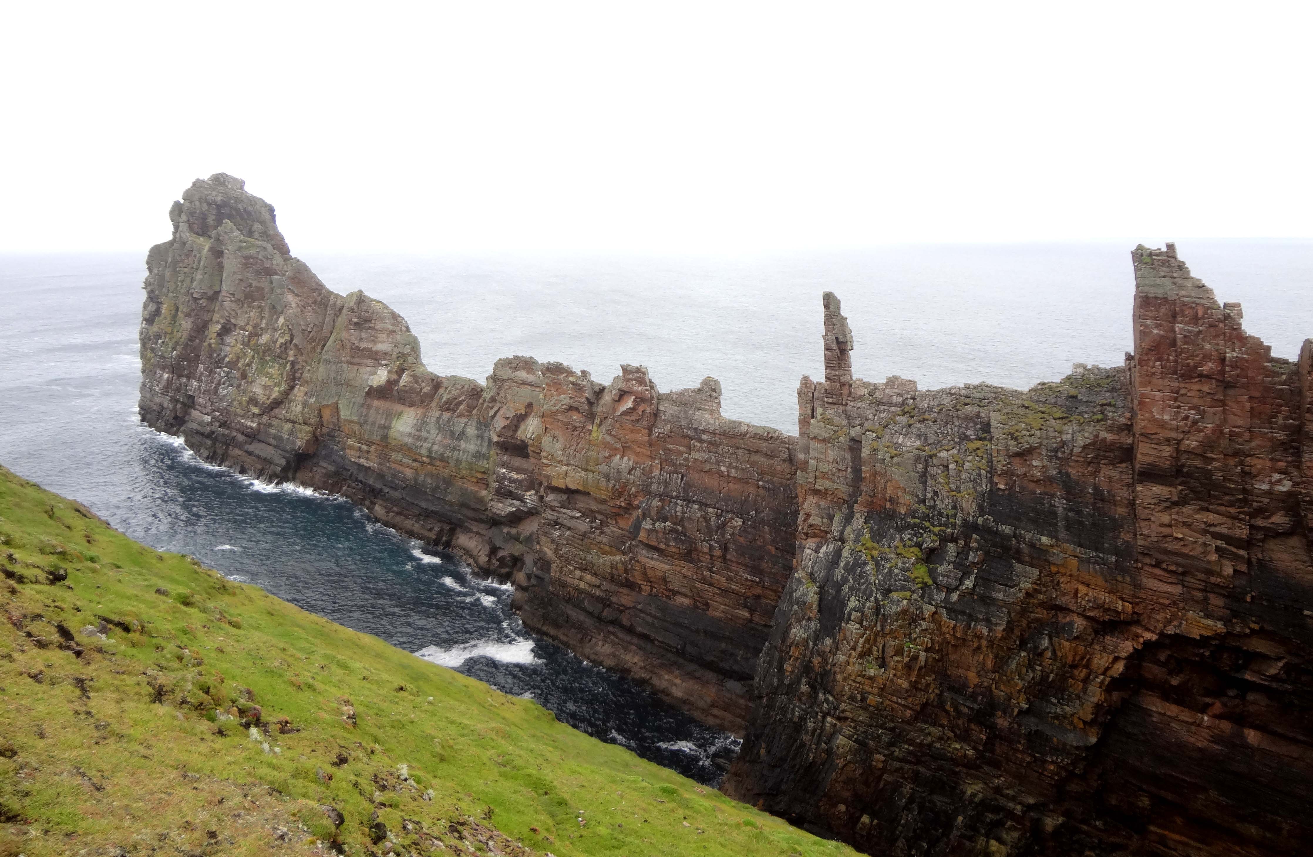
| West Village on Tory | An Eochair Mhor from fort |
This remote corner is one of the small Irish-speaking regions of Ireland, part of what is known as the ``Gaeltacht''. But the island is yet another step removed even from that community. Several years ago an outsider purchased a small holiday cottage on the island. He then left on an extended business trip abroad. Upon his return to Tory he found that his cottage had completely disappeared, its location now occupied by a parking lot for the local bar. The police (from the mainland) were never able to find anyone on the island who knew what had happened though many seemed to enjoy the improved access to the pub.
Other than its kind and welcoming people, the island's greatest asset is its natural beauty. The bird life is profuse and numerous; corncrakes, peregrine falcons, choughs and ravens flourish on the land while the gulls, kittiwakes, puffins, petrels and shearwaters populate the cliffs and seashores. But perhaps the most striking natural features are the spectacular sea cliffs along the northern coast and especially around the east end of the island. It is awe inspiring to walk along the northern cliff-top and to watch the huge Atlantic waves crash off the base of the cliffs. But the true highlight is the spectacular east end of the island known as the Dun Bhalior Peninsula. In September 2013 I made my way to the island to see this special place.
The ferry to Tory Island leaves from several mainland ports but the most convenient of these is Magheroarty (Machaire Rabhartaigh) in northwestern County Donegal. To reach this small port you drive to the village of Gortahork (Gort a Choirce) in the extreme northwest corner of Donegal. Most visitors will approach Gortahork from Letterkenny via Dunfanaghy and Falcarragh (An Fal Carrach). From Gortahork you follow the narrow coast road westwards for two miles to the coastal hamlet of Magheroarty. Note that in the Gaeltacht, many of the road signs are exclusively in Irish so it pays to memorize the Irish versions of the town names. In Magheroarty you turn left down a narrow lane leading to a pier that is readily visible from the coast road. The ferry ticket office and a small cafe are located at the base of the pier. Though the schedule changes with the season, at the time of writing the ferry for Tory leaves at 11.30am, 13.30pm and 17.00pm and returns leaving Tory at 10.30am, 12.30pm and 16.00pm. The journey takes about 40min. The boat is a rugged sea-going vessel for the crossing can be very rough. On the island the ferry docks at Camusmore Harbour in the main village of An Baile Thiar (West Village) at 55o15.92'N 8o13.57'W. The one hotel (and bar) on the island, the Harbour View Hotel, is located at the head of the pier; note that it may only be open in the summer. The rooms are basic (no TV, no phone) but clean and the breakfast and bar food are good.
A single track asphalt road runs the east-west length of the island, a distance of about 3mi. It ends at the lighthouse on the west end and at a small harbour on the east end. In addition, there may be a total of about a mile of single track dirt road. Though I did not make an accurate count there seemed to be at least 100 cars on the island, about one vehicle for every 100yds of road. That must be one of the highest vehicle densities in the world. And I didn't even count the bicycle-powered cement mixer!!! Midway along this road is the main village of An Baile Thiar (West Village) where the ferry docks. About a mile east is the smaller village of An Baile Thior (East Village). As with most of the villages in the Gaeltacht there are few people to be seen.
I set out one morning from the hotel in An Baile Thiar to explore the eastern end of the island and its dramatic sea-cliff scenery. At the end of the village I passed the little local church surrounded by gravestones inscribed in Irish and then paused at the tiny museum where some of the island paintings are stored. A small plaque dedicates the museum to ``Lord Hugh Douglas-Hamilton'' though why the islanders would acknowledge the British aristocracy seems to me strange indeed. A little further on, midway between An Baile Thiar and the smaller village of An Baile Thior (East Village), a World War II torpedo stands by the side of the road having been recovered from the sea, defused and erected there by the islanders. As I mused irreverently about Lord Hugh and the torpedo, I could not help but reflect in more serious vein on the psychology of the downtrodden. On how unfairly the history and associated legends are written by the conquerors. The local mythic king Balor is remembered as evil, reputedly the perpetrator of many ruthless deeds while the English butchers who committed very real atrocities on the island on a number of occasions are barely remembered. Instead there is a memorial plaque to the worthless ``Lord Hugh''. Where are the remembrances of the leaders who helped the island survive? I vote for a reconstructed Balor who built the spectacular fort on the west end where his people could find safe refuge. And today I vote for Patsy Dan who has done so much to cause the island to be remembered and to allow the community to survive.
As I came to the outskirts of An Baile Thior, I forked left at 55o15.64'N 8o12.72'W and continued on the road through the silent village. I could not help but wonder how many eyes watched my progress through the quiet drizzle. Perhaps that silence is the only way to survive in a land beleaguered by the conqueror and the climate. Leaving the village, the road dips down and approaches the east end of the island. There, about 20min from the start, I forked left fork onto a dirt road (the asphalt turns right for another hundred yards or so). A sign here describes the Black Choughs (black crow-like birds with red beaks) that inhabit this area. About 100yds along the dirt road takes you to a low saddle (55o15.42'N 8o11.69'W) narrowly separating a large inlet on the north coast called Port Challa from a bay on the south coast called Port an Duin. The road ends here but a well-worn use trail proceeds down to the saddle and up the other side (winches at the saddle are used to transport boats between the north and south sides of the island). This narrow land-bridge leads to the large multi-pronged peninsula at the east end of Tory Island known as the Dun Bhalior Peninsula (The Peninsula of Balor's Fort), the spectacular highlight of the island, scenically and archealogically. It is the site of an almost impregnable Early Iron Age Fort, the home of the legendary King Balor of the Evil Eye who features in many of the myths and legends of the northwest.
After the very short climb up from the Port Challa/Port an Duin saddle you access the surprisingly flat top of the peninsula. The small section of this flat-top to the south or right was the former site of a small, square fortification known as Tory Castle. Probably built in the 15th century (though coins of both the 14th and 17th century have been found nearby), this castle existed at the time of the 1608 massacre of the island population by an English army. By the 19th century only the foundations remained and nothing can be seen today (Patsy Dan is anxious to have an archeologist excavate this site).
Turning northwards I began a clockwise tour of the peninsula. Awesome views emerged as I ascended northwards across the bare mesa atop the cliffs that line the east side of Port Challa. This is a sloping natural ramp that gradually narrows as you ascend. It was the site of ancient fields serving the fort further north and, later, Tory Castle to the south. About 200yds up this narrowing ramp, the cliff edges on the two sides come within about 10yds of each other forming the only "gateway" to the high ground and fort beyond. Moreover, the ramp steepens here and the defenders of the fort above constructed a series of earth embankments whose outline are visible today. These defined the narrow southern boundary of Dun Bhalior and the only access to the high ground beyond. Today a short climb over these earth embankments bring you to the area of rock-strewn ground dotted with rock cairns, the site of Dun Bhalior, or King Balor's fort at 55o15.62'N 8o11.64'W. Surrounded on three sides by 300ft vertical sea cliffs, and accessible only by the narrow gateway guarded by the earth embankments, it is a virtually impregnable stronghold, probably first occupied in the Early Iron Age though it may have been first utilized in the Late Bronze Age. Legend has it that it was the stronghold of the mythical King Balor, king of a tribe known as the Fomorians. Many stories are told of this mythical figure, King Balor of the Evil Eye. According to the 12th century annals, Balor was slain and the Fomorians driven from the mainland by the powerful Irish tribe, the Tuatha de Danaan. There is much evidence of human occupation of the fort, particularly the outlines of small, semi-subterranean huts as well as several wells. But the site is so bleak and exposed to the raw Atlantic weather that it is hard to imagine that it was used for more than a refuge. Nevertheless it is a special place, historically, archealogically and scenically and perhaps deserves more attention than it has been given.
The highest ground just beyond the rock cairns, narrows to a dramatic point with an awesome ocean view in all directions. Here the cliffs to the east and west drop vertically for 300ft into the roaring Atlantic Ocean. From this vantage point you can see the whole of Tory Island, the lighthouse at the west end and the main village of An Baile Thiar. No one could approach the island by sea without being visible from this point. A large balanced rock on the very tip of this apex is known as the Wishing Stone or Leac na Leannan, the lover's stone. A wish is granted to anyone foolish enough to step onto it and turn around three times or to throw three stones that end lying on top of it. The overhanging cliff beyond the Wishing Stone drops more than 90ft down to a narrow, terminal sea-stack.
Continuing the clockwise tour around the flat-top, you turn right to view another awesome sight, An Eochair Mhor, the Big Key. This long and dramatic, cliff-sided linear spur juts out from the east side of the main promontory for several hundred yards, culminating in a crag called Tormore Summit (An Tor Mor, the Big Rock) topped by a visible cairn. This remarkable, knife-edged promontory slices out into the raw ocean with cliffs on all sides and a serrated, raw rock apex only a few feet wide. The south end of the Big Key is joined to the main part of the peninsula by a very narrow ridge that accesses a slightly broader grassy area known as An Tinneoin, the Anvil (a small, oblong enclosure on the Anvil may be the remains of a lookout). Just north of the Anvil, An Eochair Mhor is interrupted by several vertical rocky pinnacles known as Balor's Soldiers. These prevent further transit along An Eochair Mhor and further north. Technical equipment and a strong constitution would be needed for further progress. At the north end the Big key ends in a crag called Tormore Summit (An Tor Mor, the Big Rock) at 55o15.85'N 8o11.43'W and protected by a final 40ft climb.
I did not proceed along An Eochair Mhor but stopped at the Anvil. Others have accepted the challenge to climb along the apex of the An Eochair Mhor to Tormore Summit. The first section seems easy for one can bypass the first of Balor's soldiers on the steep grassy slope on the east side of the Key. Beyond this are a number of rock climbing challenges in order to circumvent peaks along the serrated ridge. These obstacles necessitate technical equipment and the traverse culminates in a 40ft vertical ascent to the Tormore Summit. A cairn on top of that summit indicates successful ascents (the main challenges appear to be the 200ft exposure and the inclement weather). Video of a technical climb of An Eochair Mhor can be found at http://iain-miller.blogspot.com/2012/09/tory-island-rock-climbing-donegal.html .
Resigned and pensive I returned along the narrow ridge from the Anvil, wishing that I had brought with me a rope and a fellow climber. Resolving to return, I continued my circumnavigation of the cliff-top by contouring south around the dramatic, cliff-ringed bay between the Anvil and the main peninsula, a bay that is known as Balor's Prison. Passing through King Balor's fort once again one encounters a small well and circular depressions about 15ft across that are the remnants of huts. Further around the bay, you can look back north to see the sea-tunnel under the Anvil that connects the channel between An Eochair Mhor and the main promontory with Prison Bay.
Back at the first saddle, I turned left and followed the cliff-edge path that led down to the small harbor in Port an Duin. Only a solitary lobster pot indicated any activity in that harbor. It took less than an hour to
wander back along the low-lying south coast of the island and past the torpedo to the main village and the hotel. I had seen much to occupy my thoughts along the way. Most of all, I had experienced a majestic cliff-top refuge surrounded by awesome rock and a raging ocean. Only the fear of strange, dangerous men could have induced anyone to live in this fierce place, especially given the difficulty of prying a living from the meagre soil and the cold, cold sea. It is hard to understand why the English would not leave these people alone, to live out their lives in this remote, hard-scrabble place. Sometimes history is very hard to understand and almost impossible to truly comprehend.
Last updated 9/20/13.
Christopher E. Brennen