ADVENTURES AROUND THE WORLD
© Christopher Earls Brennen
Hike B3. Nonequito Canyon, Turrialba, Costa Rica
- Hiking time: 5 hours
-
Estimated hiking distance: 3.4 miles

- Elevation gain: 870 feet
- Topo Map: Costa Rica 1:50,000 Topographical Map, #3445-1, Turrique
- Difficulties: 5 rappels up to 100ft
- Special equipment: Helmet, harness, rappel device, 200ft rope, 50ft webbing, 5 quicklinks
- Permit: Non-commercial canyon (guide from Explornatura, Turrialba, www.explornaturaCR.com, recommended)
- ACA Rating: 3C III
Characteristics
The Central American country of Costa Rica is a prime destination for canyoneers because there the sport is significantly developed and, for US canyoneers, presents a new dimension of experiences. This is because Costa Rica has a spine of steep mountains and volcanoes covered in dense tropical forest. Consequently the canyons through this forest are spectacular and present very different flora and fauna, a very different visual experience than any in the USA or Europe. Many small companies run guided canyoneering (or rather canyoning) trips through their local canyons (for example Pure Trek Canyoning and Desafio in La Fortuna and Explornatura in Turrialba) These companies have developed ``commercial canyons'' and the trips through them are not cheap, averaging about $60 to $90 for a half day descent. However the first time visitor is strongly advised to sign up for these commercial canyons and not attempt any wilder, ``non-commercial'' canyons that might involve unwitting trespass or worse. In this compendium we describe a number of commercial canyons that the author descended and recommends, some near La Fortuna in the Arenal Volcano area northwest of San Jose and some near Turrialba southeast of San Jose. For balance we also describe a ``non-commercial'' canyon near Turrialba though a guide would also be needed to find the entrance to and exit from that canyon.
The defect with commercial canyons is that they have usually been significantly altered to ease the passage for the guides and their clients. These alterations often include the installation not only of extensive fixed anchors but also of wooden platforms from which to enter the rappels. Some even have steps cut in the canyon bottom rock to ease downclimbs while in other canyons trails conduct the clients from one rappel to the next. Despite these alterations the canyons are spectacularly beautiful with luxurious multi-level canopies of tropical forest and exotic flora and fauna. It is a unique experience for a howler monkey to let loose with its terrifying howl just as you are about to enter a 150ft free rappel!
However, Nonequito canyon described here is a non-commercial canyon in the sense that it is in its natural state. However, you probably still need a guide to aid in accessing and exiting the canyon. The Explornatura Adventure company of Turrialba had guided this canyon in the past and may be willing to provide a guide for an experienced group of canyoneers. The canyon features not only a wild and natural tropical canyon but also a spectacular series of rappels beside and in a vigorous river. Though Nonequito means something like "no take away" you will take away some great memories from this adventure.
Trailhead
From Turrialba you take the main highway southeast toward Siquirres and Eslabon for about 8km. Just after the bridge over the Reventazon River, turn right onto road 232 at Angostura and Eslabon and, 2km further, turn right again onto the dirt road 234 toward Atirro. Continue along that dirt road for another 4km past a flooded area on your right and through the hacienda of Atirro, where you make a right turn to cross the bridge. The road now becomes rougher and you proceed through extensive sugar cane fields gradually ascending toward a ridge up ahead. Then, 5km from Atirro, as you near that wooded ridge on your left turn left at a small hacienda (Hacienda Iuray) and follow the mud road as it climbs up the wooded ridge. Just after a small summit you should arrive at the small hamlet of Pejivalle (marked La Veintiseis on the topo map) where you can get some food before or after the adventure. From Pejivalle the road descends again to the river. The trailhead is the bridge over the river about 1km beyond Pejivalle.
Hike
From the bridge/trailhead at 2040ft elevation, follow the farm track alongside the cane fields proceeding upstream on the right side of the river. After crossing and wading in the river to regain the track, you will come to a fork in the river where you proceed through a gate, cross the right fork (looking upstream) and follow another farm track as it switchbacks up the ridge between the forks. Nonequito River is the fork on your left looking upstream. Follow the farm track as it climbs up the steep ridge until you come to a fence gate where the farm track contours into the Nonequito drainage but a steep and muddy trail continues up the apex of the ridge. Continue up that apex trail as it leaves the developed fields and becomes a trail through the forest. About 1hr 15min from the start at an elevation of 2910ft, you finally come to a summit where the trail almost peters out. Here there is a faint fork but you should proceed ahead down a steep, slippery slope to the Nonequito river about 50ft below. You should reach the stream at an elevation of 2860ft roughly 1hr 20min from the start.
|
|---|
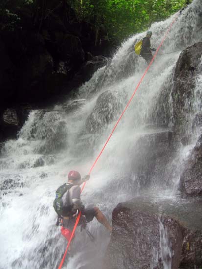
| Fourth rappel in Nonequito Canyon (Photo by Luca Chiarabini) |
Beginning the descent of Nonequito Canyon you almost immediately come to a shallow slot downclimb where you will need to swim the pool at the bottom. This is followed by the first rappel where the stream drops into a narrow ravine. The anchor is a tree along the ledge on the right and the rappel drops you into a pool for a swimming disconnect.
From this first rappel it is only about 100yds to the top of the big series of falls in this canyon. The first section is a downclimb on the left to a platform where you cross to the right and find a bolted anchor in the right wall. You should reach this anchor at an elevation of 2730ft about 2hr 40min after the morning start. The 60ft rappel from this bolted anchor is an exciting challenge. You descend down sloping rock to a groove where the water funnels into a short but vigorous waterfall where you will descend through a brief maelstrom. Downstream of this challenge, is another downclimbable cascade where you should work your way down on the left to another bolted anchor on top of a boulder on the left. You should reach this point at an elevation of 2620ft about 3hrs from the start.
The 50ft rappel from this bolted anchor proceeds down a wide vertical cascade with spray flying all around. At the bottom that ``rain'' fills the canyon. Just a very short distance downstream is another 50ft rappel, this time from a tree on the left a short way back from the lip. You should reach this point at an elevation of 2570ft about 3hrs 20min from the start. The descent is down through another broad cascade with a series of steep and rough steps. From the bottom of this cascade, proceed along a narrow and somewhat exposed shelf on the left to a recess beside a large tree that can be used to anchor the last rappel. This is a steep 100ft descent of the sidewall of the canyon down into a deep pool. You should reach the bottom of this last rappel (elevation 2420ft) about 4hrs from the start.
From the bottom of this last rappel it is
boulder-hopping, stream hike of about 30min to the point where
the exit trail leaves the stream. It is on the left just after a nice small
plunge pool but is not easy to spot. It would be difficult to find without
a guide. You should reach this exit point (elevation 2340ft) about
4hrs 30min from the start. The exit trail roughly follows benches
to the left of the river
until you come to the start of the farmed area where you veer
left to pick up the farm track that you used during the hike in. Once on that
farm track you follow it back to the access route and then back to the trailhead.
The total duration of the hike is about 5hrs during which you cover
about 3 miles.
If you leave the vehicle(s) in Pejivalle it is another 15min hike
back to that village.
Last updated 8/10/07.
Christopher E. Brennen