ADVENTURES AROUND THE WORLD
© Christopher Earls Brennen
Hike A3. El Laberinto
- Hiking time: 2.8 hours
-
Estimated hiking distance: 0.5 mile

- Elevation gain: 270 feet
- Topo Map: Mexico 1:50,000 Topographical Map, #G14C36, Allende
- Difficulties: 3 rappels up to 110ft, one large stagnant pool.
- Special equipment: 200ft rope, 160ft rope for guided rappel, helmets, harnesses, rappel devices, 20ft webbing, various carabiners
- Permit: None required
- ACA Rating: 3B I
Characteristics
In the Monterrey Peaks National Park, west and south of the city of Monterrey, Mexico, there are a number of spectacular canyoneering adventures. In this collection we feature three canyons in this National Park, namely Chipitin, Matacanes and El Laberinto, the first two of which are world class adventures. This is the third which is a half-day adventure suitable for the beginning or end of an extended visit.
These are rugged limestone mountains riven through with caves and with travertine encrusted canyons. Many are wet with blue-green pools and travertine rock formations. In contrast, El Laberinto is mostly dry though the major technical challenge is getting across one rather spicy pool in a narrow slot.
The base for this hike is the same as for Matacanes and Chipitin, namely the Hotel Hacienda Cola de Caballo in Santiago near Monterrey, Mexico. To get to the hotel drive 36km south of Monterrey toward Cuidad Victoria on Mex.85 through the Villa de Santiago and turn off the highway at El Cercado where there is a signpost for Cola de Caballo. Drive 5.5km up NL20 to the hotel entrance on the right (25o22.14'N 100o9.61'W and elevation 2240ft). As with Matacanes and Chipitin you might choose to contract with one of the local guide services such as Aventura (http://www.aventura.com.mx/) who are connected to the Hotel Hacienda Cola de Caballo. However this short hike and access to it are much more easily accomplished on your own than are Matacanes and Chipitin.
Trailhead
The starting point for the El Laberinto adventure is the village of La Cienega high up in the mountains above the hotel. To get there from the Hotel Hacienda Cola de Caballo (elevation 2200ft) you continue up the asphalt road (Nuevo Leon 20 or NL20) toward Laguna de Sanchez, cresting the top of the ridge and descending into the gentler valleys on the western side of the range. Your destination is ``kilometer 19'' about 14km from the hotel. It is a point where the road rounds a rocky headland and there is a large crucifix with a metal Christ on the apex of the curve on the right side. There is also a low stone wall and after you park make your way back to the east end of the wall (25o22.44'N 100o12.99'W). The village of La Cienega is about 1km further along the road so if you encounter the village you should backtrack. Park somewhere close to the metal Christ.
Hike
The hike starts at the east end of the low stone wall (25o22.44'N 100o12.99'W and elevation 4740ft). Just 20yds down the ridge from the end of the low stone wall you will find an anchor around a tree at the top of a vertical drop into El Laberinto canyon. The drop is 110ft but a doubled 200ft rope will reach a ledge with an easy downclimb to the bottom in the dried up streambed. Turning left and hiking downstream it is just 50yds to the second rappel, a simple 30ft rappel from a bolt in the middle of the lip. Another 50yds brings you to the narrow gully for which this canyon was named. In this slot there is a substantial 60ft drop that can be tackled using several options. The first is to use the bolts about 10ft down the slot to rappel down to a broad empty pothole floor and then continue through a narrow gate down to a large stagnant pool that requires swimming. The alternative is not to descend into the gully but to contour over to the shelf on the right where there are several bolt anchors. The first descender from here must swim the stagnant pool but you can then set up a guided rappel utilizing several of the bolts at the top and a hole-in-the-rock on the right side of the beach at the far end of the pool. The guide rope needs to be very tight to avoid landing in the water. You should reach this point about 2hr 15min from the start.
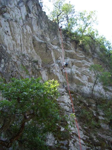
|
|---|
| First rappel down into canyon (Photo by Ira Lewis) |
The guided rappel is the main challenge during this transit of
El Laberinto. It is immediately followed by a simple
20ft rappel from a bolt in the center of the lip. After this the
canyon opens up and you walk down the gravel wash into the village
of La Cienega where you veer left to get back to the road, NL20,
at about kilometer 20.5.
You should reach the road at
25o22.46'N 100o13.35'W and
an elevation of 4470ft about
2.5hrs from the start.
Turn left and hike back up the road to your vehicle.
Last updated 5/16/05.
Christopher E. Brennen