ADVENTURES AROUND THE WORLD
© Christopher Earls Brennen

Hike E1. Hua Shan
- Hiking time: 3 hours
-
Estimated hiking distance: 2.7 miles

- Hike elevation gain: 1093 feet
- Topo Map: See attached map
- Permit: Pay fee at entrance
Characteristics
Perhaps the greatest of the five sacred mountains of China, the precipitous, multi-peaked Mount Hua (or Huashan in Chinese) rises almost vertically up out of the Yellow River basin some 75mi east of Xi'an, the ancient capital of Shaanxi Province in central China. Part of the Qin Ling mountain range, it was (and is) a religious refuge of great significance for the followers of Taoism who believed it to be the home of the god of the underworld. A temple known as the ``Shrine of the Western Peak'' existed at the foot of the mountain as early as the 2nd century BC and purportedly allowed pilgrims, Taoists, Buddhists and other sects to communicate with the god and his servants. In more recent times, the temple at the base of the mountain became known as Yuquan Yuan or the Jade Spring Temple and is one of the main Taoist temples in China. Of classic South China architectural style with several pavilions surrounding a central pond, a long corridor of seventy-two windows leads to the Huixin Rock that marks the start of the climb up Huashan mountain.
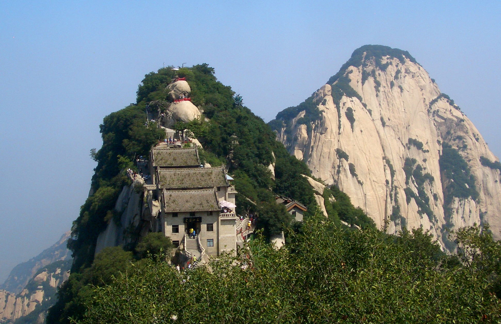
As time went on precipitous trails were carved into the gorges and cliffs to the south and the peaks overhead began to be decorated with beautiful temples that attracted pilgrims from all over China. The first to be adorned was the 5299 ft North Peak, known also as Yuntai Feng or the Cloud Terrace Peak, on the end of a dramatic ridge high above the Hua Shan gorge. Now the lowest of the five major peaks, it is nevertheless an awesome and spectacular place of pilgrimage. Today two trails lead up to the North Peak. The traditional route is the stairway of 370 rock steps called the Qianchi Zhuang that begins at the Huixin Rock in the Jade Spring Temple in Huashan village on the plain below. First cut into the rockfaces of Hua Shan Gorge in the 3rd and 4th century AD and improved during the Tang dynasty, its steps snake for 3.7 mi up to the North Peak. A second route up to the North Peak originates in the adjacent Huang Pu gorge was also built in the Tang dynasty but fell into disrepair and, until 1949, was only known to local villagers. In that year a group of about 100 Kuomintang soldiers were occupying the North Peak when a small group of Communist soldiers were led up that trail by a local guide, surprised the Kuomintang detachment and took them prisoner.
Today that second trail is well-maintained and a modern cable car follows the same route up to the North Peak from Huang Pu gorge. This allows a host of daily visitors to enjoy the spectacular views from the North Peak. They begin by travelling to the bus terminal at the entrance to the Huang Pu gorge (34o31.69'N 110o5.79'E and elevation 1460 ft) near the city of Huayin some 75 mi east of the ancient capital of Xi'an. After purchasing their tickets, they then board a bus that winds up to the cable car terminal (34o29.74'N 110o5.57'E and elevation 2789 ft) deep within the gorge. From there it is a spectacular cable car ride up between towering sandstone cliffs to the North Peak station at 34.49188oN 110.08119oE and an elevation of 5299 ft.
|
|---|
| The North Peak |
Hike
The 5299 ft North Peak (34.49188oN 110.08119oE) was not the end of the trail for those pioneering pilgrims. To reach the other great pinnacles to the south they needed to ascend a steep, knife-edged ridge just behind the North Peak known as the Canglong Ling or Black Dragon Ridge. Here they carved a fantastic stairway up the apex of the rock-topped ridge that climbs about 1000 ft to an only-slightly less daunting, wooded ridge-top where the stairway continues up toward the four other sacred peaks. Until modern times when another parallel trail was built off to the east to allow one-way traffic, the Black Dragon Ridge was the only route to the higher peaks. At the top of the Black Dragon Ridge climb, the pilgrim passes through the Jinsuo Guan or Gold Lock Pass at 5631 ft and about 0.7 mi from the start. The Golden Lock Gate is so called because one of the traditions practiced by pilgrims to Mount Hua is to emboss their wishes on a gold-coloured padlock and to attach this lock to the railings at Gold Lock Pass (and elsewhere along the route). Enormous numbers of these locks have accumulated at Gold Lock Pass, so many that a massive number were recently detached and melted down to create a huge gold-lock statue some 14 ft long and 5 ft high that was mounted just beyond the pass as a tourist photo stop. At this point just beyond Gold Lock Pass, trails branch off to the West, Center, East and South Peaks. We head to the 6699 ft Center Peak.
The Center Peak is capped by a Taoist temple named the Jade Maiden Temple. The name is derived from the legend that the daughter of the emperor Qin Mugong (569-621BC) loved a man who played the Chinese flute (tung-hsiao) and she withdrew from the court to become a hermit. Other scenic spots on Center Peak include the Rootless Tree and the Sacrificing Tree, each with their own legends.
But the first stop on a tour of these summits should be the 6890 ft East or ``Facing Sun'' Peak. Most of trail consists of stone steps cut into the rock; railings on both sides protect against huge vertical drop-offs on both sides. One very steep section leads to a vertical``sky-ladder'' leading from a ledge to a higher rock. When you reach the East Peak you are treated to a magnificent view of the mountains off to the east. The view of the sunrise is said to be fantastic if you happen to be there at dawn and the weather is favorable. From the viewpoint, one can traverse to the spectacular Chess Pavilion, a small but magnificent folly built on a projection in 1987 on the spot where Chin Shou Huang is said to have played chess with the gods.
Proceeding on toward the 6392 ft South Peak, you first descend a steep set of stairs from which you catch sight of Changkong Zhandao, the famous ``Plank Walk'' reached 1.1 mi from the start at an elevation of 6017 ft. It is a short but hair-raising detour to the 15 ft long plank walkway set in a rock face atop a vertical cliff above a huge vertical drop of thousands of feet. To reach the plank walk you must first descend about 30 ft of near-vertical stairway cut into the cliff-top. Attendants will supply you with a safety harness by which you can hook yourself into the cables that run along above the planks. So secured, you may be able to make your way along to the end of the 15ft plank walk where a small cave allegedly represents the long-ago retreat of a Taoist monk.
After the plank walk detour you return to the main trail where a comparitively easy walk will take you to the 6392 ft South Peak, the summit of Mount Huashan, about 1.6 mi from the start of the hike. Heading back toward the Gold Lock Pass you pass the Center Peak and along the much-photographed knife-edged ridge to the Taoist temple that adorns the West Peak. This completes the tour of the Huashan peaks and you begin the descent by returning to the Gold Lock Pass after a total of 2.0 mi of hiking. There you begin the long descent down to the North Peak. The Canglong Ling stairway near the bottom of this descent by which you ascended is one-way so you must veer off to the right to descend by an alternate and less precipitous trail. From the bottom it is a short hike down to the cable car station after a total day hike of just 2.7 mi.
As you ride down on the cable car and catch the shuttle bus back to Huayin, it is inevitable that you will marvel at the devotion and persistence of the monks who carved these fantastic pathways into their sacred mountain and who would be astounded (and perhaps shocked) by the crowds who travel from many corners of the earth to enjoy the beauty of their labors and the magnificence of nature.
Last updated 20/6/14.
Christopher E. Brennen