ADVENTURES AROUND THE WORLD
© Christopher Earls Brennen
Hike I1. Fraser Island
- Conveyance: Commercial tour
-
Duration: 11 hours

- Vehicle: 4WD Mercedes bus
- Equipment: Swimsuit and towel
- Topo Map: Attached map
- Permit: Included
Characteristics
Fraser Island, the island of sand, lies off the coast of Queensland, Australia, about 120 miles north of the city of Brisbane. It is the largest island in the world composed entirely of sand and has a structure that is the result of a huge supply of coastal sand combined with an unrelenting onshore breeze. These have created one of the longest beaches in the world, stretching almost unbroken for 75 miles along the east coast of Fraser Island. In a process of evolution that still continues, the on-shore wind then carries this sand up onto a whole series of patches of sand dunes called ``sandblows'' that stretch inland from the eastern shore. The sandblows are of the order of a mile in width and several miles long. On each, the sand builds up into dunes that move eastward raising the height of the land to over 700ft; these sand mountains drain to both the east and the west. As sand piles up on the beach, this process also results in new land added to the eastern side of the island. In between the sandblows are old dune fields that have been overgrown by brush while the old sand land to the west has been covered by older brush and forest. In places the result is open sandy scrubland; in other places it is now dense rainforest. The western coast, sheltered from the Pacific surf and storms, is relatively stagnant, in places dense mangrove swamp, in other places lined with soft beaches. In the central and western parts of the island there are many beautiful, clear water lakes, formed where the drainage has been interrupted by the travelling sand. And everywhere the streams consist of the clearest water flowing over sparkling sand beds with little rock to be seen anywhere. Indeed the absence of rock and stones underfoot or underwater, is just one of the features that make this a very special place, fully deserving its designation as a World Heritage Site.
The wilder northern half of the island is now the Great Sandy National Park; the southern half is managed by the Queensland government as Fraser Island Recreation Area. Vehicle access and camping are by permit only. Visitors either arrive on guided tours in four wheel drive buses or in their own (or rented) vehicles. Buses and cars alike drive off the ferry onto the western beach and thence onto the system of rough dirt roads that are the main thoroughfares on the island. In addition, the long eastern beach makes for excellent driving and is the main north/south artery. A network of trails also allows exploration beyond the limits of the rough dirt roads.
The first European to encounter Fraser Island was probably the Portuguese explorer de Menonca who sailed this coast in 1521. During the subsequent 250 years, only occasional adventurers, Portuguese, Dutch and English, came this way leaving little trace and few chronicles. It was first documented in detail by James Cook, who landed on the island (which he thought was part of the mainland) in May 1770 and named many of its prominent features. The pace of exploration increased after Cook; Matthew Flinders landed near the northern cape in 1802 and others followed. The island became notorious in the aftermath of the adventures of James and Eliza Fraser.
In May 1836, the brig ``Stirling Castle'', Captain James Fraser in command, set sail from Sydney for Singapore. A week later it was wrecked on a reef off what is now Rockhampton to the north of Fraser Island. Taking to the boats, the survivors, including Captain Fraser and his wife Eliza, drifted south for several weeks, eventually landing on what is now known as Fraser Island. There they resorted to walking south but were taken prisoner by a group of aborigines who stripped them naked and made them work. Captain Fraser was speared and died of his wounds several days later. During a two month sojourn on Fraser Island, other members of the group died or were killed. Eliza Fraser and the first mate, Brown, eventually escaped with the assistance of one of their captors (probably an escaped convict by the name of David Bracewell who had been living with the tribe). In the aftermath, Eliza's story was widely circulated. She made many public appearances, retelling her story in a more and more graphic detail with each repetition. As a result, the island gained notoreity and was thereafter known as Fraser Island.
The aborigines, a tribe called the Butchulla, had traditionally visited the island on a seasonal basis. In the 1860s they were forced out by the lumber companies who came to harvest the trees of the island's rainforest. That harvest included the valuable satinay trees that had proved quite resistant to the marine pest that destroyed the ships hulls of the day by boring through the wood. Logging on Fraser Island did not finally cease until 1991.
Trailhead
We had travelled to Hervey Bay to visit this unique island of sand. A regular bus collected us from our hotel early one July morning in 1997 for the brief trip to the Urangan boat harbor (25o17.77'S 152o54.56'E). There, along with the four wheel drive bus that was to provide our transportation for the rest of the day, we boarded the ferry for the brief voyage to Fraser Island.
Hike
The ferry, which was built just like a landing craft, headed north before turning east and approaching the beach at a place on the west coast of Fraser Island just north of Moon Point (about 25o12.42'S 153o0.40'E). There the ferry simply lowered its ramp onto the soft sand beach and the 4WD bus drove down the ramp onto the beach and across it into the scrub forest. We followed on foot and boarded the bus for the cross-island drive.
|
|---|
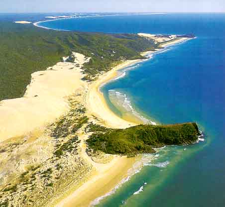
| The eastern coast of Fraser Island. |
The sandy road was rutted by regular traffic so the bus bumped and lurched its way along, first across flat terrain coated with strange and wonderful scrub. Gradually the forest thickened with larger and larger trees creating a canopy with a lush undergrowth below. Here the runoff from the high dunes to the east has created a network of crystal streams and clearwater lakes edged with the purest sand. It is the absence of earth and mud that makes this land so strange, so magical. We passed through the Yidney Scrub, home to great stands of virgin Kauri pine, the trees so sought after by the ship-builders for their resistance to marine life. And we took a short side trip to visit Lake Garawongera (25o19.80'S 153o9.58'E), one of those pristine lakes. A sand goanna was primming itself on the lovely beach when we arrived and only reluctantly decided that the crowd was more than it could tolerate. Our guide recommended that we wash our gold jewelry in the sand by the edge of the lake and the lustre of Doreen's gold ring did seem to rise. Back in the bus we drove the last of the 15 miles from our landing beach at Moon Point to Happy Valley (25o20.28'S 153o12.04'E), a rustic resort close to the great eastern beach where signs strongly discourage feeding the dingoes who have become persistent pests. There we lunched in the open-air restaurant.
Refreshed, we mounted our 4WD wagon for the afternoon tour. The bus made its way onto the packed sand of the great 75-mile beach and we were soon sailing smoothly along toward the north in a style in stark contrast to the morning's bump and grind. In no time we covered the 4 miles to where a substantial stream, Eli Creek, empties into the ocean (25o17.78'S 153o13.34'E). A delightful trail meanders inland alongside Eli Creek, allowing one to enjoy the lush tropical forest of banksia and pandanus trees fed by the water of the creek. But the crystal stream devoid of any mud or rocks allows an even more delightful experience, namely a swim down the last halfmile or so of creek. With only fine sand on the streambed there was no danger of scraped knees or toes despite the shallow depths. The sparkling clear water and the lush foliage made this a quite unique experience. I could not resist a second descent.
A couple of miles further north we came to the wreck of the ``Maheno'' (25o16.03'S 153o14.31'E), a rusty skeleton lying partly buried in the 75-mile beach. More than 50 vessels have foundered on the shores of Fraser Island; indeed the wreckage became of such concern that, in 1870, a lighthouse was constructed at Cape Sandy on the northern tip of the island. But even with the lighthouse, wrecks still occurred. Today, the most visible is the ``Maheno'', a former luxury liner and World War I hospital ship. In 1935, it was being towed to a scrapyard in Japan when it was blown ashore in a storm. To add to the indignities, it was used for target practice during World War II. Further along the beach, some three miles north of Waddy Point, an Italian luxury yacht, the ``Marloo'', became beached in 1914 after encountering rough currents on Sandy Cape Shoal. It now lies beneath the surface of the water where it is a favorite dive site.
As we were inspecting the ``Maheno'' we were amazed to see two light planes approach and land on the beach just a few yards from where we were standing. The pilots disembarked and approached the crowds around the ``Maheno''. It transpired that they were seeking passengers for ``Air Fraser Island'' and offering a brief aerial tour of the island. I could not resist and soon, along with two other passengers, I was roaring along the beach in a Cessna flown by a wizened bush pilot, reputedly the best in the world. No sooner were we aloft than we veered over the ocean looking for sharks. Many seemed to be lazily patrolling the shoreline perhaps seeking Eli Creek descenders who had failed to stop at the beach! Then we turned inland for a close aerial view of the Knifeblade sandblow, one of those great moving dunes that had built the island. Further west we had a good look at the inland lakes and streams before turning for home. It was a special thrill to sweep down and land on the beach, the surf almost within arm's reach.
But the hours of daylight were dwindling and after a brief stop to see the rain-sculpted cliffs known as ``The Pinnacles'' we began the long drive back across to the west side of the island. There the ferry was beached, ready and waiting for the bus to cross the sand and drive up the ramp. Soon we were chugging back to Urangan boat harbor.
It had been a special day on a unique island, a naturally crystal
place of bright sand, sun and surf. I felt like an interloper, especially
in the great 4WD Mercedes bus. Maybe only people like Mark Moxon should
be allowed there. But that would be to deny so many a glimpse into another,
different and pristine world.
Last updated 3/10/03.
Christopher E. Brennen