ADVENTURE HIKES AND CANYONEERING
IN THE SOUTHWEST
© Christopher Earls Brennen

|
|---|

|
Hike K8. Zuma Canyon
- Hiking time: 4 hours
- Estimated hiking distance: 4.1 miles
- Elevation gain: 1430 feet
- USGS Topo Map: Point Dume
- Difficulties: Much bouldering and scrambling; some navigation
- Special equipment: None
-
ACA Rating: 2A III

Characteristics
It still seems quite remarkable to me that, within a few miles of cosmopolitan Los Angeles venues such as Venice Beach, Santa Monica and Malibu, one can with only modest effort hike to almost pristine wilderness where there is little likelihood of encountering another human being. Such is the case in Zuma Canyon, a deep cleft in the Santa Monica mountains, that begins near the crest of that range and empties into the Pacific at Zuma Beach. Despite its ruggedness Zuma Canyon can be traversed without technical gear for almost its entire length. Only near the top are there several waterfalls that must be rappeled. Otherwise it makes an excellent, non-technical adventure hike. We describe here a route that avoids those rappels by entering or exiting through Newton Canyon. The hike can be done in either direction, but we proceed upstream here since route finding is slightly easier in this direction.
The hike can be undertaken at almost anytime of the year except after heavy rain when it could be dangerous. It is easiest in the fall when the stream almost dries up. But it is much prettier in the spring when the stream is running (there are a number of excellent swimming holes). The summer may be rather hot.
Note: This is one area in which the topographical maps are significantly out of date and could be misleading. There is an extensive dirt road system known as the Kanan Edison Road that was built to service the power line and pylons. This is not shown at all. In addition, there are trails that are not indicated, specifically the Backbone Trail and smaller trails connecting to the Kanan Edison Road. Moreover, the aforementioned powerline is not shown.
Trailhead
This hike requires either a car shuttle or the placement of bicycles for the return along the road. The first trailhead is the Backbone Trail parking area at 34o4.56'N 118o48.93'W which is 1.8mi south of Mulholland Highway on the Kanan-Dume Road (Highway N9) that runs south from Agoura and Route 101 to the Pacific Ocean near Malibu. This parking area is on the west side of Kanan-Dume Road close to where it crosses Newton Canyon and just north of the southernmost road tunnel. It is heavily used by bicyclists who ride the Backbone Trail in the Santa Monica Mountains National Recreation Area.
Having parked one vehicle or deposited bicycles at the Newton Canyon parking area, you should then drive 4.1mi south on the Kanan-Dume road to Pacific Coast Highway (Highway 1), turn right and drive 0.8mi, turn right again on Bonsall Drive and north 1mi to where the road ends in a broad, dirt parking area. This is the Zuma Canyon trailhead. Park here at 34o1.89'N 118o48.73'W.
Hike
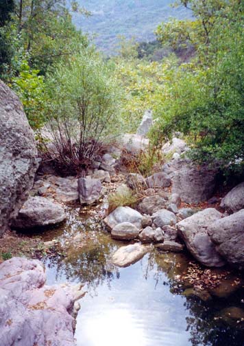
A broad, dirt road proceeds north from the parking area (elevation 90ft) and the hiking is easy over the flat Zuma Canyon flood plain. This is a pretty, wooded area with a number of marked trails to either side. Staying on the main trail as the canyon gradually closes in, the well-maintained dirt road abruptly ends beside the creek bed after about 20min or 1mi of hiking. Henceforth the route is through wilderness with only short sections of use-trail. However, the canyon is relatively free of dense brush and, at least initially, one can make progress quite easily. Just beyond the end of the dirt road is a small dam holding a shallow pond and, thereafter, you boulder-hop your way along the side of the stream with many pretty glades and pools. Soon you are in complete wilderness, less than three miles from crowded Zuma Beach. The canyon shrinks in width and you proceed through Zuma Narrows (at 34o2.96'N 118o49.00'W) though these do not have the vertical walls of other, better known narrows. Along this stretch you should take note of the Edison power lines that cross the canyon high above you. About 1hr 25min from the start, you pass under these power lines.
 | 
| |
|---|---|---|
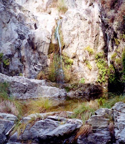
| Zuma Canyon below Newton Canyon Junction | Waterfall above Newton Canyon junction |
About 15min beyond the power lines, look for a trail that joins the creek from the right; it enters near a large tree growing beside the streambed. This trail climbs the canyon wall to meet the Kanan Edison dirt road (about which more later). Continuing upstream from the trail junction (elevation 480ft), you will arrive at a place where a large canyon comes in from the left. We hesitated here before being convinced that the route through the main canyon was to the right. Just beyond this junction you climb the first of the many rocky cascades you will encounter in the upper section of the canyon. After the first stretch of bouldering, the canyon flattens out temporarily and here, at an elevation of 800ft and 2hr 15min from the start, you come the the place where the aforementioned Kanan Edison Road crosses the creek at 34o3.98'N 118o49.34'W. This dirt road was built to service the power pylons and connects to the east with the Kanan-Dume Road and to the left with a dirt road that runs along the top of the ridge to the west.
Beyond the Kanan Edison Road, there is a long succession of waterfalls that require some route finding to bypass. It is slow going but a spectacular wilderness with a lovely stream and many marvellous pools to swim in or picnic beside. About 25min beyond the dirt road there are some bright red cliffs, one on the left with a startling grey stripe. Then there are more waterfalls to negotiate, one of which requires a detour through the brush on the left. Just beyond this and about 1hr 15min from the Kanan Edison Road, the going abruptly eases, the canyon broadens and the floor flattens. Here, at an elevation of 1280ft, there is a lovely section of bedrock pools with sculpted rock and small cascades. It is a great place to stop, rest and enjoy the solitude. As you do so, take note of the fact that you can now see a highway crossing the hillside ahead of you. This is the Kanan-Dume Road and it provides a sure way of identifying the canyon junction ahead. Just beyond the bedrock pools, at an elevation of 1315ft you will arrive at the junction of Zuma Canyon with Newton Canyon. They meet in a tranquil wooded and relatively flat section of canyon bottom at 34o4.63'N 118o49.12'W. Since Newton is a large tributary identification of this junction is straightforward.
Though our route takes us up Newton Canyon (the right fork at the junction), it is pleasant to embark on a brief detour and to hike a little further up Zuma Canyon (the left fork) to the waterfall that blocks further progress in that direction. It is a pretty, 30ft waterfall that cascades down into a series of broad, shallow pools in a vertically-walled gorge. It takes but 10min of easy streambed hiking to get there from the Newton Canyon junction.
Back at the junction, you begin the ascent up Newton Canyon. Almost immediately you will encounter a 40ft waterfall that looks formidable but is readily bypassed using a steep (but airy) use-trail on the right. Several hundred yards upstream of this you come to a second obstacle, a 20ft waterfall. Here you should climb the steep, rocky slope on the left and proceed through the bushes to a well-worn trail. Turn left and this will join another maintained trail that proceeds south across the head of Newton Canyon. Then it switchbacks up the hillside to the Backbone Trail parking lot where you left the return vehicle or bicycles at 34o4.56'N 118o48.93'W.
It should only take about 25min to ascend Newton Canyon from Zuma
Canyon to this
parking area (elevation 1520ft). From there it took me just
35min of leisurely cycling to ride the 5.9mi back to the Zuma
Canyon trailhead (34o1.89'N 118o48.73'W), following the route taken earlier.
Last updated 12/1/00.
Christopher E. Brennen