ADVENTURE HIKES AND CANYONEERING
IN THE SOUTHWEST
© Christopher Earls Brennen

|
|---|

|
Hike D1. Zion Narrows
- Hiking time: 13 hours
- Estimated hiking distance: 15.7 miles
- Elevation gain: None
- USGS Topo Maps: Straight Canyon, Cogswell Point and Temple of Sinawava or Zion National Park Topographical Map
- Difficulties: Many miles of hiking in the river, several pools requiring chest deep wading and, perhaps, swimming. Some boulder climbing
- Special equipment: A stout hiking staff. Pack all belongings in waterproof bags
- Permit: Obtain permit from Backcountry Desk in Zion National Park Visitor Center.
-
ACA Rating: 1B IV

Characteristics
The North Fork of the Virgin River begins high on the 7000-8000ft Markagunt Plateau in southwestern Utah, about a hundred miles north of the Grand Canyon. In these early reaches there is little that distinguishes it from hundreds of other streams that gather water from the summer thunderstorms and the winter snow melt and help irrigate the rolling hills, meadows and forests of the sparsely populated, open sky country of that high plateau. The spectacular nature of the North Fork only becomes apparent if you follow it to the edge of the plateau, where it has carved a chasm 2000ft deep into the Markagunt and created the truly spectacular canyons of Zion National Park. For 16 meandering miles that chasm is an incredibly narrow ``slot'' canyon, in places only 20 to 30ft wide with vertical walls rising out of sight on both sides. Later it broadens to form the wider, yet still awesomely vertical canyon visited by those who drive up from the south entrance to see Zion National Park by autombile. But to really experience the magnificience of the North Fork of the Virgin, you must venture into the narrow, storm-sculpted sandstone gorge they call the Zion Narrows. With its raging rapids, its soaring, fluted walls and hanging grottoes it is a rare and awesome place.
The best way to make this pilgrimage is to begin high up on the Markagunt Plateau, north and east of the Park, and to follow the river all the way down through the Narrows to the point where it emerges into the broader canyon of Zion National Park. Though it is marginally possible to accomplish this in one very long day hike, it is clearly preferable to overnight in the canyon. This requires a permit from the Park Service and the allocation of one of the ten small campsites that are located along a central stretch of the canyon where there are occasional spots of accessible high ground.
There is, of course, danger involved in that adventure for the storms that sculpted the Zion Narrows still occur and the slot canyons still focus the runoff and create raging flash floods that crash through the canyon sweeping all before them. The bare rock of much of the surrounding land does not absorb much water and the steepness of the terrain accelerates the runoff. And, worse still, there are miles of canyon in which there is little or no accessible high ground where hikers can seek refuge from these floods. The Park service posts stern warnings about this danger and issues flash flood alerts but these efforts cannot eliminate the risk. During a flash flood the water level rises almost instantaneously - within minutes or even seconds. The hiker must not only find high ground in any local rainstorm but must also be aware of the flood potential of quite distance storms. Thus he or she must be alert to the other signs of a possible flash flood such as rapid increase in the muddiness of the water or the roar from the upstream flow. Because of the danger in the Zion Narrows, the Park Service does not issue permits to hikers until the day before the intended hike and suspends the process when thunderstorms are imminent.
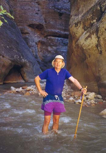
A second, less obvious danger in this adventure is the possibility of hypothermia. For more than half of the length of the hike, there is no alternative but to hike in the river itself. While this is usually no more than about a foot deep, there are places where it is necessary to wade through chest deep pools and once or twice you must swim. This means that the hiker is wet for a substantial fraction of the time (``wicking'' clothing of polyester or similar material is essential) and, since the sun does not penetrate the depths of the Narrows very often, prolonged coldness can lead to serious hypothermia even in mid-summer. At other times of the year, a wetsuit is essential.
A permit is required for all through-hikes in the Zion Narrows. Camping permits for the recommended two-day, overnight hike are limited and you must arrive at the Visitor's Center in Zion National Park early in the day preceding your hike in order to obtain a permit. In this process you will be allocated one of the small campsites midway along the route.
Trailhead
The starting point for the Zion Narrows hike is quite some distance from the Park at Chamberlain's Ranch (37o23.11'N 112o50.34'W) so the hike involves either a long 4WD vehicle shuttle or a ride in a commercial van shuttle to the trailhead. To set up the car shuttle park one vehicle at the Zion National Park Visitor's Center (37o12.02'N 112o59.24'W). Then, in the other vehicle, drive north along Zion Canyon Road, turn left at the road junction in the Park and follow the spectacular Zion-Mt.Carmel Highway as it climbs the east wall of Zion Canyon before exiting the Park. About 2.5mi beyond the East Entrance to the Park, turn north on a paved road that changes to dirt after several miles. The road winds its way across the plateau and then descends to cross the Orderville River, climbing again and cresting a ridge before descending to a bridge that the crosses the North Fork of the Virgin River. The distance from the main highway to this bridge is about 18mi. The dirt road turns right after the bridge (37o23.43'N 112o49.55'W), but you turn left and, after 0.25mi arrive at the gate to Chamberlain's Ranch (37o23.38'N 112o49.79'W). Proceed through the gate and drive another 0.5mi to a rough open area just before the road fords the river. Park here at the trailhead (37o23.11'N 112o50.34'W).
Hike
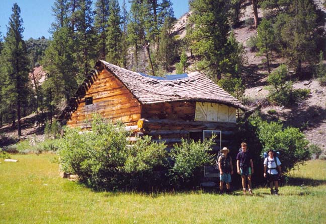
The remote ranchland where the hike begins is delightfully bucolic, a gentle river valley with a stream and rolling pastures surrounded by low, tree-covered ridges. You follow the rough dirt road as it crosses and then parallels the North Fork on its route eastwards. About 50min from the start you pass an old wooden structure, Bullock's Cabin (37o22.30'N 112o52.10'W), that may have once served as home to some proud pioneer but has long since been converted to a shelter for the ranch cattle. Soon the pastureland and the road ends and the valley sides begin to close in as the Virgin River cuts more deeply into the Markagunt Plateau. This stretch provides a beautiful and serene hike on a bright summer day. A well-worn use trail makes progress easy though the river crossings increase in frequency and difficulty.
|
|---|
| Bullock's Cabin |
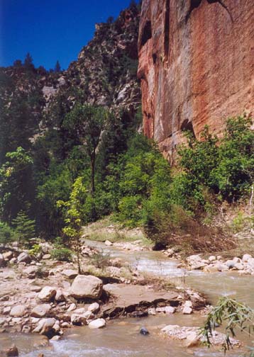
About three hours from the trailhead, the walls become vertical and the valley is transformed into a classical ``slot'' canyon with fantastic sculptured walls and cool grottoes. Shortly thereafter (3.5hrs from the trailhead) the width between the walls closes in so that, in places, they are as close as 20ft. You have arrived at the first narrows. But, the bottom remains quite flat. For much of the way, the river occupies most of the width of the canyon bottom and the sediment carried by its frequent flash floods is apparently sufficient to even out the longitudinal grade to one that only produces small cascades. And even these seemed temporary having been formed by logjams. When we travelled this way the first substantial logjam occurred about 5hr from the start; it was easily climbed. But the pool downstream of the jam was murky and therefore of uncertain depth. It turned out to be just over waist deep. Just a short distance beyond the logjam, you encounter the only substantial waterfall (37o21.75'N 112o56.86'W) on this hike, a vertical drop of about 15ft in a very narrow section. Fortunately, a crack in the rock off to the left provides an easy passage around this otherwise difficult hurdle. A short distance downstream of the waterfall, there is a deep pool that you have to swim. You then immediately arrive at the readily recognized junction (37o21.57'N 112o57.11'W) where Deep Creek joins the North Fork from the right. There is a broad beach in the middle of this cathedral-like junction, towering vertical walls on all sides. It takes about 6.5hr to travel from the trailhead to this junction.
 | 
| |
|---|---|---|
| Upper Canyon | Entering First Narrows |
Deep Creek has a significantly larger volume flow rate than the North Fork and so the river downstream of the junction is notably deeper and harder to hike through. The numbered campsites also begin at the Deep Creek junction. Number 1 lies in a slight rise just to the south and you can count your way down as you approach your assigned site. About 40min below the Deep Creek, you will pass the junction where Kolob Creek (37o20.97'N 112o57.05'W) enters from the right. Our campsite, Number 7 or ``Boulder Camp'' was a particularly pleasant one just a few minutes south of Kolob Creek. It even had a large overhanging rock that would provide excellent shelter in the event of rain (we had chosen not to carry a tent since the weather forecast indicated little chance of rain).
Resuming the hike the next day, the canyon becomes quite rugged downstream of Boulder Camp. Regular stretches of white water require a practiced eye for navigation. You pass other numbered camps, finally passing Number 12 (``High Camp'') and, 300yds later arriving at Big Springs (37o19.87'N 112o57.43'W), a notable feature in which a very substantial stream issues from springs in the right canyon wall. Ferns and other greenery adorn these springs and make it a pleasant place to stop. You should reach Big Springs about 1hr 30min after Boulder Camp.
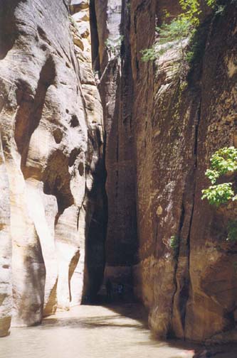
Up to this point, though the towering walls soared over 2000ft on all sides, there were still occasional places where the canyon widened and small, sloping benches of trees and ferns were scattered along the sides of the river. Often these provide the easiest route of passage downstream. More importantly, they could serve as refuge in the event of thunderstorms or flash floods. Indeed, like all the other overnight sites, Boulder Camp had been situated on such a sloping, wooded bench. However, downstream of Big Springs, the canyon walls close in even further and the river and its beaches fill the entire width of the base of the slot. For more than three miles there are no benches on either side. No greenery, no refuge, and no direct sunlight except for a few minutes around noon. Just awesome vertical walls, running water and the gravel it carries with it. The memory of that majesty will last a lifetime. Even in mid-summer when the desert high above boils in the midday sun, down here in the depths of the Zion Narrows it is cold and wet and you must keep moving to prevent hypothermia. Because the risk of unexpected thunderstorms and flash floods is least, it is optimal to pass through the Zion Narrows during the morning hours.
 | 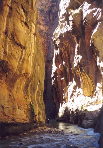
| |
|---|---|---|
| First narrows | Zion Narrows |
It takes a little over 2hrs to travel through the heart of the Zion Narrows. In all that time, you will enjoy no direct sunlight. But, just upstream of the junction with Orderville Canyon, the Narrows widen a fraction and, on the inside of a lefthand turn, you may come, as we did, to a marvellous sunlight beach where we warmed ourselves and rested. There we encountered the first hikers coming upstream from the Temple of Sinawava; they had set out early that morning to explore the Narrows from below.
Downstream of the sunny beach, you are again plunged into the
shade of the Narrows. Almost immediately you will encounter the junction
with Orderville Canyon (37o18.49'N 112o56.81'W),
a narrow slot entering on the right. The previous
day you crossed the upper reaches of Orderville on your drive to
Chamberlain's Ranch and the descent of Orderville Canyon is an
adventure described elsewhere in this journal.
A short distance downstream of Orderville junction, the canyon broadens
a little and the wooded benches appear again. Sunlight penetrates
and it is a beautiful hike downstream to the the point where
the concrete Riverside Walk begins
(37o17.80'N 112o56.90'W). By this stage there
will be crowds of people enjoying the canyon and the adventure of a short
hike up into this wilderness.
It takes about 5hrs 20min to travel from Boulder Camp
to the Riverside Walk and just about another 20min to reach
the Temple of Sinawava (37o17.11'N 112o56.86'W).
From here, board the Zion Shuttle Bus for the trip back to the Visitor's
Center (37o12.02'N 112o59.24'W)
and your return vehicle.
Last updated 9/9/99.
Christopher E. Brennen