ADVENTURE HIKES AND CANYONEERING
IN THE SOUTHWEST
© Christopher Earls Brennen

|
|---|

|
Hike K23. Wonderland of Rocks
- Hiking time: 6 hours
- Estimated hiking distance: 5.5 miles
- Elevation gain: None
- USGS Topo Maps: Indian Cove
- Difficulties: Much bouldering and route finding
- Special equipment: 50ft rope as a precaution
-
ACA Rating: 2A III

Characteristics
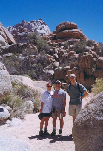
Joshua Tree National Park is reknowned for two unusual natural features. First the cactus-like Joshua trees that give the Park its name. And second the truly spectacular rock formations that cover a significant fraction of the desert landscape of the park. These sculpted and multishaped rock formations protrude from the flat desert floor like great fossilized dinosaurs. Add a solid, high-quality rock surface with many pock-marks and small projections and it is easy to understand why Joshua Tree is a world-reknowned mecca for rockclimbing. The challenges for the climber are almost limitless and the documented routes fill a huge rock-climbing guidebook. Two regions of rock formations are particularly popular because they can be accessed by car: the Indian Cove area around a campground just about 3mi south of Highway 62 and the Hidden Valley area near the center of the park. Hidden Valley has a campground in a box canyon once used by cattle rustlers; it is the most popular destination for casual visitors. Lying in between these campgrounds (that are about 5mi apart as the crow flies) is a wild and fabulous wilderness known as the Wonderland of Rocks. While several trails penetrate a short way into the Wonderland and one trail leads around it, there is no conventional hiking route through it because the terrain is so rugged. But, to experience the true wildness and awesome wonder of Joshua Tree National Park it is necessary to embark on a traverse through the Wonderland of Rocks. That is what this adventure is all about. Though not long in terms of distance, it is a tough and demanding hike requiring much bouldering and route finding through a maze of rock masses. The traverse can be accomplished without technical gear unless you are most unlucky. However, to cover that remote possibility I do suggest you carry a 50ft rope and some webbing.
The hike should not be attempted during the summer because of the overwhelming heat and the high probability of hyperthermia. It is, however, ideal for a dry winter day. Even then I recommend carrying at least two quarts of fluid per person since there is water at only one stop along the way and even that may not be safe to drink. Sunscreen and a hat are also a must.
Trailhead
The starting points for this hike are the Joshua Tree National Park entrances along Highway 62, a road that closely follows the northern boundary of the park. Since the adventure hike requires a car shuttle, two or more vehicles should be driven along Highway 62 to the Indian Cove turnoff several miles west of the town of Twentynine Palms. The Indian Cove campground is about 3mi south of Highway 62. From the center of the campground, turn right following the signs to the picnic area that is about 1mi east and slightly south. Park one vehicle where the road ends (34o5.18'N 116o8.47'W). While there it is also wise to try to fix in your mind the principal natural features surrounding this terminus of the hike. In particular notice the high ridge to the east of the picnic area. This runs roughly north/south and its rocks look distinctly different from those of the Wonderland to the south and southwest of your vantage point. We found the ridge a valuable navigational aid during our hike through the Wonderland since it is visible during most of the later part of the hike.
Having deposited the return vehicle, drive back out of the park and proceed east on Highway 62 to the town of Joshua Tree where you should turn south following the signs for the Park Entrance. About 6mi southeast of the town, you will pass the Park tollbooth. Another 6mi beyond the booth, just after passing the Quail Springs picnic ground on the right and about 2mi before Hidden Valley, you should be able to locate the Keys West backcountry trailhead (34o2.44'N 116o11.17'W) on the left side of the road. Parking is limited since many rockclimbers use this trailhead. Park in the small lot or by the side of the road.
Hike
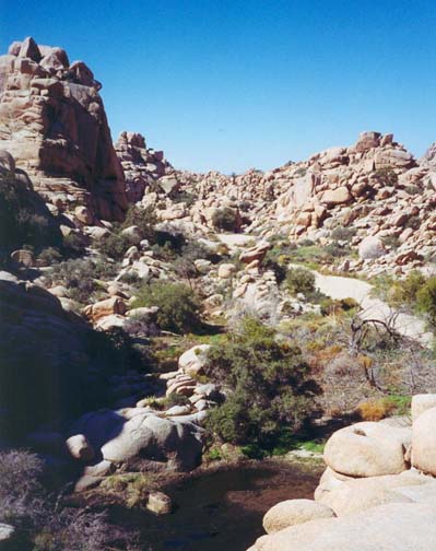
From the Keys West trailhead (34o2.44'N 116o11.17'W and elevation 4037ft) the flat and straight trail proceeds slightly east of north toward the rockpiles that stick out of the flat desert in the distance. Here the route is part of the Boy Scout Trail that proceeds around the west side of the Wonderland of Rocks to its destination at Indian Cove. But you are bound through the center of the Wonderland and so it is necessary to identify a trail fork (34o3.47'N 116o10.78'W) about 1.3mi from the trailhead where the Boy Scout Trail forks right. Take the left fork that is clearly headed for a flat gap between two major rockpiles. The heading soon turns east and the flat area you are traversing gradually narrows. Soon you reach an almost imperceptible crest and begin a gentle descent into a narrowing valley. Follow the dry watercourse that soon begins to snake back and forth between great blocks of buff-colored rock. Eventually as the rock formations on either side become higher and higher, the watercourse broadens into sandy flats and, about 3.3mi from the trailhead, you arrive at the verdant water pools of Willow Hole (34o4.13'N 116o9.10'W). This is a very pleasant place to stop and enjoy, a great place for lunch. Many drooping willow trees surround surprising large pools of mostly clear water containing an abundance of special life. Great rock cliffs surround you on all sides. Take time to enjoy this marvellous place before the challenges that lie ahead.
 | 
| |
|---|---|---|
| Entering the Wonderland of Rocks | Willow Hole |
It should take less than 1.5hr to reach this point and
the map might lead you to believe that this is going to be a short and easy
hike. However, be warned that by far the toughest and longest part of the
hike lies between Willow Hole and Indian Cove and so you should not delay
too long. The way ahead involves lots of bouldering.
Moreover, from Willow Hole on it is considerably harder to find the route.
Indeed it seemed clear to us that there were a number of alternative
use-trails all of which would lead eventually to Indian Cove. Basically there
are two major east/west ridges that separate Willow Hole from Indian
Cove. The route first follows the watercourse that runs east from Willow
Hole (veer to the south as you leave Willow Hole to avoid a particularly
difficult boulder pile) and then turns north to make its way
through a gap in the first
ridge. You then emerge into the second east/west valley known as
Rattlesnake Canyon (34o4.64'N 116o8.75'W)
and turn right to proceed east (downstream) along
the watercourse to a gap in the second of the two ridges. Here you should
begin to discern a more distinct trail. Follow the
Rattlesnake Creek trail north through this gap and
descend down a steep gully to the Indian Cove picnic ground
(34o5.18'N 116o8.47'W and
elevation about 3200ft).
Throughout this cross-country route from Willow Hole to Indian Cove, the
prominent north/south ridge to the east of Indian Cove should be visible.
It provides a valuable navigational aid; most of the time you should
be proceeding toward it. However if you start climbing the ridge you
are going the wrong way. It took us about 4hrs to cover the short
distance (a little over a mile as the crow flies) from Willow Hole to
Indian Cove.
Last updated 9/9/99.
Christopher E. Brennen