ADVENTURE HIKES AND CANYONEERING
IN THE SOUTHWEST
© Christopher Earls Brennen

|
|---|

|
Hike E2. Coyote Buttes/The Wave
- Hiking time: 3 hours
- Estimated hiking distance: 6 miles
- Elevation gain: 340 feet
- USGS Topo Maps: Pine Hollow Canyon, Coyote Buttes
- Difficulties: A modest navigational challenge
- Special equipment: A compass and topo map
-
ACA Rating: 1A II

Characteristics
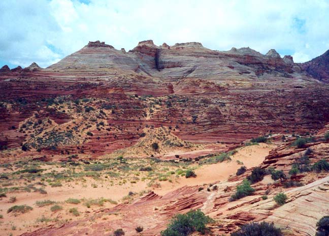
The vast region of Arizona and Utah north of the Grand Canyon is largely uninhabited wilderness, a rugged and parched landscape of desert and mountains where thunderstorms bring deluges of rain that tear the land apart leaving great gullies and cliffs for those who venture to enjoy in solitude. Within this wilderness are many places of awesome grandeur and beauty. One of the most remarkable is a rock formation known as "The Wave", a psychedelic contortion of sandstone rock that lies on the slopes of the Coyote Buttes in the Paria Canyon - Vermillion Cliffs Wilderness Area managed by the Bureau of Land Management (BLM). Close to the Arizona/Utah border, this Wilderness is just south of US Highway 89 approximately midway between Page, Arizona, and Kanab, Utah.
This adventure takes you across a trailless, rocky landscape from the Wire Pass Trailhead (the same trailhead as used for another of these adventures, namely Buckskin Gulch) to "The Wave". Apart from some modest navigational challenges, it is a relatively easy hike across some marvellous and barren desert mountain terrain to a spectacular geological oddity.
We note that "The Wave" and the hiking route to it are protected areas and can only be entered with a special permit (just ten are issued for each day). Permits ($5 per person) can be obtained in advance (see the website http://paria.az.blm.gov ) or, on the day before your hike, from the BLM Paria Ranger Station between mile markers 20 and 21 on US89. With the special permit will come a parking permit for the Wire Pass Trailhead (for other dayhikes, you purchase the parking permit at the trailhead itself). You will also be issued a crude copy of a topo map indicating the route to "The Wave".
Trailhead
Coyote Buttes and "The Wave" are south of US Highway 89 between the cities of Page, Arizona, and Kanab, Utah. The hike begins at the Wire Pass Trailhead in the Paria Canyon - Vermillion Cliffs Wilderness managed by the BLM (Bureau of Land Management). The turnoff from US 89 is unmarked but is located between mile markers 25 and 26 approximately 34mi west of Page or 40mi east of Kanab. It is 4mi west of the Paria Ranger Station where you may have obtained your permit for this hike. You turn off onto a dirt road known as House Rock Valley Road; it is a good quality road easily passable in a 2WD vehicle under dry conditions. When wet it can become impassable. About 4.2mi south of US89 you will pass the Buckskin Trailhead on your left; 3.7mi further on you will finally arrive at the Wire Pass Trailhead (37o1.19'N 112o1.48'W and elevation 4860ft) with a broad parking area and a restroom on the right side of the road. The actual trailhead is on the left.
Hike
Leaving the Wire Pass Trailhead you follow the Wire Pass wash eastwards (downstream), initially following the same route you would take to Buckskin Gulch. After about 0.5mi or 10min of hiking down the broad, open wash you will come to a gentle curve to the right where a broad, well-worn trail (actually an old dirt road) veers up and off to the right at 37o1.24'N 112o1.09'W. Here a sign in the creekbed indicates that others should proceed straight on in the wash if bound for Buckskin Gulch. The sandy trail climbs up to the top of a low ridge, turns south and levels off, heading toward a horizontally striated butte.
|
|---|
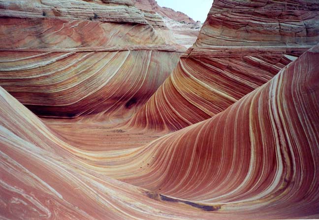
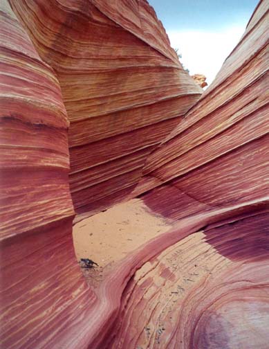
| The Wave |
About 25min or 1mi from the start, the trail ends just after crossing a wash and arriving at the bottom of a low, bare-rock ridge. Veer left a short way and climb an easy gully up to a saddle at the top of the ridge (37o0.75'N 112o0.62'W). From the saddle contour around the other, eastern side of the ridge and proceed south paralleling the ridgetop without losing elevation. The ridge to your right rises and you continue to head south up and over a low rise. From here you should recognize two prominent twin cones almost straight ahead of you on the flank of the ridge. Climbing somewhat, you should head for the left side of these cones. There, about 70min and 2mi from the start at 37o0.35'N 112o0.49'W, you will cross the border between Utah and Arizona, marked by a rather desultory barbed wire fence. Here it is very important to identify the landmark that will guide the rest of your way to "The Wave". In the distance, almost due south of you, are the buttes where "The Wave" is located. On those buttes there is a prominent black crack running vertically down from the summit toward the base of the mountain. From here on you head almost directly toward the black crack.
 | 
| |
|---|---|---|
| The black crack in the distance | The Wave |
Leaving the twin cones, you proceed across relatively flat, bare rock and arrive about 20min later at a flat rock bench overlooking a wash with the black crack buttes on the opposite side. Descend to the sandy wash heading directly for the black crack and cross the wash (36o59.98'N 112o0.38'W) by a prominent black marking on the rock in the creek bed. On other side, climb the moderately-sloped rockface veering a little right toward a shallow, steep gully heading up toward the black crack. Stay in this shallow gully as the slope eases, and it will lead you directly to the bare rock entrance to "The Wave" at 36o59.77'N 112o0.40'W and an elevation of 5200ft. You should arrive there about 1hr 20min after leaving the trailhead.
The area covered by "The Wave" is not large but you should take time to explore the various gullies where this unusual psychedelic phenomenon is most prominent. It is as though the rock has been smoothly folded almost back upon itself and several times over. The rock sides seem to be flowing in waves that almost break and that image will shimmer in the hot desert sun. You can also climb above the contorted, wavy strata into the bowl at the base of the black crack that served as your navigational beacon. High overhead on the ridgeline there is a substantial natural arch.
You retrace your own footsteps on the way back to the Wire Pass Trailhead,
a task made more difficult by the total absence of any markers other
than those you registered on the outbound leg. Consequently, this is
one hike where you should look backwards on your way to "The Wave" to pick
out and memorize your own route markers for the return trip. The total
time for the hike is about 3hr.
Last updated 6/30/01.
Christopher E. Brennen