ADVENTURE HIKES AND CANYONEERING
IN THE SOUTHWEST
© Christopher Earls Brennen

|
|---|

|
Hike A7. Fish Creek Canyon
- Hiking time: 6.5 hours
- Estimated hiking distance: 8.2 miles
- Elevation gain: 300 feet
- USGS Topo Maps: Weavers Needle, Horse Mesa Dam
- Difficulties: Some bouldering, modest downclimbing and wading; some route finding
- Special equipment: Gaiters and gloves
-
ACA Rating: 2A III

Characteristics
The Superstition Mountains, 40mi east of Phoenix, Arizona, are a mix of grand desert scenery, tortured canyons and rugged peaks, all spiced with Indian legends and tales of lost gold mines. Fish Creek flows through one of the most spectacular desert canyons in these Superstitions on its way north to join the great Salt River. About five miles before this confluence, Fish Creek Canyon widens briefly and there the rugged dirt road known as the Apache Trail descends to the bottom, crosses Fish Creek and proceeds east on its way through the Superstitions. Thus the Apache Trail facilitates access to this marvellous gorge and makes possible an adventure hike through the deepest part of the Fish Creek Canyon.
At its deepest Fish Creek Canyon is over 1000ft deep with great towering walls of tortured rock. Where there are high ledges, they are dotted with giant saguaro cacti, seemingly standing watch over your progress. The shade and stream in the canyon bottom have created a rich foliage quite different from the desert higher up. I recommend that you go in the spring (though not within a few days after rain when the risk from floods is high) when the stream still has some substance and the wildflowers are still blooming.
This adventure hike through upper Fish Creek Canyon does not require technical equipment. Even the downclimbing is moderate. However, as described here, the hike is long and even modest downclimbing can become arduous over an extended period of time.
Trailhead
A car shuttle is advisable for this hike. From Apache Junction on Highway 60 east of Phoenix, drive east on the Apache Trail (SR88) past Canyon Lake and through Tortilla Flat. Several miles beyond Tortilla Flat the road turns from asphalt to dirt. Shortly thereafter, you pass a tourist viewpoint on your left and then begin a steep descent into Fish Creek Canyon. The road crosses Fish Creek on a bridge in the apex of the canyon. Park the return vehicle by the side of the road near the bridge (33o31.49'N 111o18.43'W). Then, in the other vehicle, drive 2.4mi back up the Apache Trail to the Tortilla Trailhead parking area (33o31.58'N 111o19.16'W) on the left side of the Apache Trail. Park here.
Parenthetically, we note that you might chose to drive rather than hike along the next section that proceeds along the very rough Tortilla Trailhead 4WD road. The first few hundred yards of this road are very rocky and may challenge even the best 4WD vehicle. If you chose to try this and you manage to ascend the large rock steps in the first section, the rest of the three mile road from the Apache Trail to the ultimate trailhead beside Tortilla Ranch is easy 4WD driving. However, I do not recommend this since it is almost as easy to walk the road once as it is to drive it three times.
Hike
From the parking area beside the Apache Trail (33o31.58'N 111o19.16'W and elevation 2880ft), hike southeast up the rough, rocky road that soon reaches flatter ground on the top of the mesa. In the spring the land here is covered with beautiful wildflowers, another reason for hiking rather than driving this section. After 30min or 1.7mi the road reaches a minor summit (elevation 3200ft) where a rustic wooden arch across the road marks the entrance to the long-abandoned Tortilla Ranch. You then begin a gradual descent into the flat valley where the ranch was located. High cliff bluffs on the left separate this valley from the Fish Creek drainage to the northeast. About 45min and 2.6mi from the start you pass through the corrals that mark the remains of Tortilla Ranch (3080ft) with an old windmill off to the right. Ten minutes later, a road forks off to the right to a second old windmill. Proceeding straight here you immediately arrive, 55min and 3.2mi from the start, at the official Tortilla Trailhead (33o29.57'N 111o17.56'W and elevation 3140ft) with a fence, rudimentary gate and sign indicating that vehicle travel beyond this point is prohibited. Proceed straight on and follow the trail as it crosses a shallow creek bed and climbs gradually up a gentle open slope.
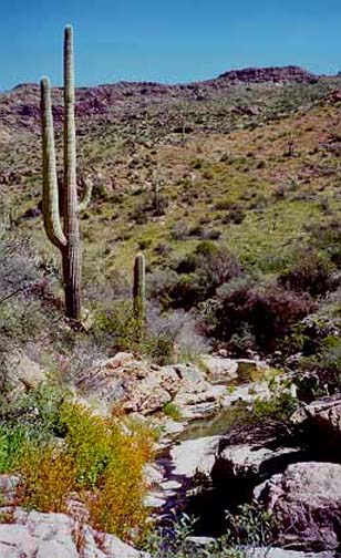
About 0.6mi beyond the first gate and 3.8mi (1hr 10min) from the start, you come to a rudimentary second ``gate" consisting of large wooden posts connected to a fence. This is a critical navigational point (elevation 3300ft). Proceed through the gate and veer left off the trail to a highpoint where you can survey the open land to the east that leads gradually down toward Fish Creek Canyon in the distance. On the left hand side of this vista you should be able to discern the start of a shallow gully (33o29.24'N 111o17.15'W) leading in a ENE direction down toward Lost Dutch Creek. There are some faint remains of an old mine at the head of this gully. Head down towards this gully; initially the bottom is choked with brambles and it is easier to make your way downstream by contouring along the left bank. Soon, however, the gully deepens (and, in the spring, water appears) and travel in the gully bottom becomes preferable. Downclimbing rocky dryfalls becomes necessary in places. This is a lovely little valley with no sign of human passage. In the spring, I saw turtles in the stream pools.
 | 
| |
|---|---|---|
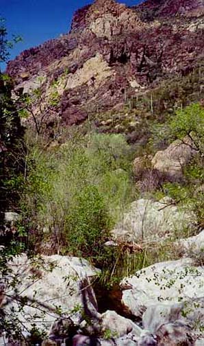
| Unnamed gully | In Fish Creek Canyon |
The off-trail route down this unnamed gully is slow going. It takes over an hour before the creek turns north and meets the often dry creek bed in Lost Dutch Canyon that comes in from the right at 33o29.50'N 111o16.51'W and elevation 2800ft. Now the dry creek bed flattens into a boulder-strewn bottom that makes for easier and faster going as you proceed downstream. Half an hour later, 3hr and 5.3mi from the start at an elevation of 2760ft, you come to the junction of Lost Dutch Creek with Fish Creek (33o29.93'N 111o16.67'W), usually a substantial stream. On all sides the 1000ft canyon walls are beginning to close in here as the stream enters the dramatic Fish Creek Canyon. But, for a while, the canyon bottom is still relatively broad and flat. The going is quite easy though wading becomes inevitable in places. Ten minutes later the canyon narrows further with rugged cliffs of tortured rock, dotted with narrow shelves populated by giant saguaro cacti. Here there is a curious pool in a cavern on the right side of the stream. Downstream of the cavern, progress gets progressively harder and you begin to have to find your way through a canyon bottom jammed with huge boulders. Further on you will need to downclimb in places and route finding becomes harder.
You are now in a spectacular narrow canyon with towering 1000ft walls on both sides. Here in the depths, the stream and the shade support a rich canyon-bottom foliage. And the stream in the spring brings clear and beautiful water to the many lovely cascades and pools, some of which make for a delightful swim. In other places, progress is only possible by wading though, when I came this way, the water never came much above my knees.
There are few readily identified landmarks during this 3.5hr transit
through the deep lower gorge though you may recognize one particular obstacle
about 1hr from the end where it is necessary to find a high rock shelf
on the right in order to bypass a huge boulder jam. Finally after the
canyon makes a sharp left turn, you arrive at a gravel flat where the
road bridge is seen ahead and above you.
But, except during the hot summer, between you and the end of the gorge is
a deep pool between vertical rock walls. In order to bypass this
pool you should follow the well-worn track that climbs about 50ft to
a large cave on the left. From there, a high trail contours over to the
road where you parked your return vehicle
(33o31.49'N 111o18.43'W and
elevation 2290ft).
You should reach the end about 6.5hrs after the morning start.
It is a 2.4mi drive back up the Apache Trail to the return vehicle.
Christopher E. Brennen