ADVENTURE HIKES AND CANYONEERING
IN THE SOUTHWEST
© Christopher Earls Brennen

|
|---|

|
Hike J5. Seven Teacups, near Upper Kern
- Hiking time: 5.5 hours
- Estimated hiking distance: 5.1 miles
- Elevation gain: 460 feet
- Topo Map: Fairview, Johnsondale
- Difficulties: Five rappels up to 60ft, some in the waterfall; some swimming
- Special equipment: 160ft rope, 20ft webbing, 3 rappel rings, harnesses, helmets and drybags
-
ACA Rating: 3C III

Characteristics
The Kern is, perhaps, the most famous and the most notorious river in California. Born high in the Sierra Nevada where a group of icy lakes above the tree line feed their meltwater into a rugged canyon, it gathers depth as it rages south past the western shadow of Mount Whitney, eventually sliding out of the southwestern end of that great mountain range. Near the end of this epic 170 mile journey, there are roads that penetrate some distance up into the Kern's massive gorge. The furthest reach is the road bridge over the Kern just a few miles east of the hamlet of Johnsondale. Just another mile up the Kern from that bridge a small tributary called Dry Meadow Creek drops down the west side of the gorge into the Kern. The final mile of this descent is precipitous and involves a long series of waterfalls in a spectacular, vertical canyon. The Seven Teacups are a succession of seven circular pools interspersed with small falls that form the first part of the descent.
This adventure involves a pleasant and easy overland hike to the head of the Seven Teacups, a descent down to the Kern, a crossing of the river and a trail hike back down to the bridge. It is a relatively short canyoneering adventure that is best for the late summer when the flow rate has ebbed. Not only is a low flow rate necessary for a safe and fun descent of the Teacups but it is also a prerequisite for a safe crossing of the Kern, perhaps the most dangerous part of this hike. My advice is to perform two important visual checks of the conditions. First, you should visually check the Kern upstream of the Johnsondale bridge before starting the hike. If you do not feel comfortable crossing the river just above the first corner then you should not proceed. Also, when you get to the top of the Seven Teacups, walk up onto the right shoulder for a view of the falls from above; if you feel the flow through the fourth falls (the narrowest of the cascades) is more than you could deal with, however briefly, then you should return to the car by the route you used on the approach.
Trailhead
The trailhead for this hike is the parking lot at the west end of the bridge (35o58.17'N 118o29.24'W) over the Kern about 3.9mi east of Johnsondale and 20mi north of Kernville on Mountain Road 99. As you drive north from Kernville, the Johnsondale bridge, as it is called, is just beyond the junction with the road to Kennedy Meadows.
Hike
Having performed the visual check of the Kern, start the adventure by hiking west from the parking lot (35o58.17'N 118o29.24'W and elevation 3880ft) up the steeply climbing road toward Johnsondale. Almost immediately, there is a view of the Kern through a gap on the right side of the road. This is followed by a lovely view of the South Creek waterfall just to the left side of the road. As it climbs the road switches back to the right and then to the left. About 0.3mi after the second switchback (30min and 1.2mi from the start at 4320ft) you should encounter a rough dirt road that branches off to the right (35o58.60'N 118o29.99'W). Follow this dirt road that rapidly peters out into a trail; even the trail disappears briefly as it enters a small gully. Continue up the gully but, when you come to a fork, the trail follows the ridge between the forks and becomes clearer. (If you lose the trail completely just hike northwest through this open country.) About 20min and 0.7mi from the highway you should come to a crest or saddle (35o58.85'N 118o30.25'W and elevation 4620ft) with an overlook to the north; just beyond the saddle the trail ends at a barbed wire fence running east/west. Climb over the fence and proceed down to the shallow gully off to the left that runs away to the north. You will follow that gully all the way to Dry Meadow Creek. Faint trails appear on one or both sides of this gully and are slightly easier to hike than the gully bottom. This is open, sparsely wooded grassland that makes for easy hiking. About 2/3 of the way down the gully and 75min from the start a dirt road comes in on the left but stops at the gully. Finally, 85min and 2.9mi from the start of the hike at an elevation of 4220ft you arrive at Dry Meadow Creek (35o59.61'N 118o29.32'W), readily recognized by the white bedrock and the flowing water.
|
|---|
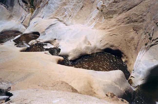
| The 4th to 7th Teacup from the right shoulder |
Turn right and proceed downstream along Dry Meadow Creek, negotiating the boulders and pools. The rock can be a little slippery so watch your step. Here there are several short sections where it is easier to take a route higher up the bank on the left. After about 30min (and a little under 2hrs from the start) you will arrive at a place (35o59.61'N 118o29.11'W) where the ravine drops off dramatically on its final descent to the Kern, only a short distance away as the crow flies. The first part of this descent, the section immediately before you, is known as the Seven Teacups. Take off your pack and reconnoitre the challenge ahead of you.
The first few small pools can be easily bypassed on the right. The rest represent a canyoneering challenge that is great fun especially on a warm summer day when a wetsuit is not needed. Drybags are, however, essential for you will be throughly soaked as you make your way down through this waterworld. There are a number of ways to descend the Seven Teacups, some of which involve jumping into the pools. It is also possible to bypass the first series of falls by going up over a shoulder ledge on the left and then descending the steep slickrock (be careful for this rock can be slippery in places). But, since the author does not jump, I describe here a rappeling descent without jumping and with only minor slickrock descent. Note also that the depth of the teacups varies considerably from time to time and from season to season. The author only had to swim a couple of times during the descent, most of the pools being no more than waist-to-chest deep. But before embarking on the descent I recommend walking up along the ledge on the left shoulder to review the challenges ahead. In particular examine the fourth waterfall, the one that proceeds through a narrow gap. If the spout here seems more than you can handle I suggest you return by the way you came.
Back at the top descend to the pool before the first rappel. The flow into this pool proceeds through a small natural arch and this provides the anchor for the rappel down the first three waterfalls. Rappel down the sloping slab to the left of the first waterfall (about 12ft high) and then continue down the left part of the second and third drops (about 6ft and 8ft respectively). Then, here in the third teacup (counting one teacup at the bottom of each rappel), make sure you find the bolt in the right wall at the top of the fourth falls before you pull your rope. Set the rope through this bolt anchor and prepare to rappel down the next two falls. The first of these, a 20ft drop, is a challenge for one must rappel down through the concentrated spout that corkscrews through this narrow lip. Use your helmet to deflect the barrage. Quickly you will find yourself in the relative calm under and behind the waterfall. The next drop (about 15ft) is somewhat easier since it is broader but one must still content with a maelstrom at the bottom. The next sloping cascade is small (6ft) and is easily bypassed on the right. The one that follows drops into the last and seventh teacup; it is also small (10ft) and can be downclimbed using small ledges just to the right of the falls. You should reach the last teacup (elevation about 4110ft) about 1hr after leaving the top and 3hr after the morning start.
 | 
| |
|---|---|---|
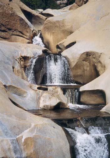
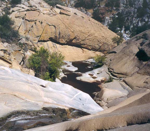
| The 4th to 7th of the Teacup falls | Lip of last drop from top of the penultimate |
You will now be at the top of the tallest waterfall in the descent, a 60ft rappel using a tree anchor on the left side. This drops down into a narrow slot where there is just room to avoid the violent hammering of the main spout. There is a brief struggle against the flow in order to climb out of this slot and continue downstream where the water flows through another narrow slot before you come to a much broader rock ledge with a view down toward the Kern. You can bypass the next few cascades first, briefly on the right, and then by downclimbing a series of broken ledges on the left. This allows you to bypass a 40ft waterfall where the creek turns left.
This brings you to the top of the final drop before the Kern, now plainly visible below you. This final drop involves a two stage rappel for reasons that are not clear from the top. The first rappel is from an anchor high on the right side of the lip. Climb up a somewhat exposed ledge with cracks to a narrow platform. One of the two possible anchors is a stout tree that is about 10ft above the platform. That tree is the preferred anchor but, if the final part of the climb is not to your liking, there is an alternative anchor: webbing placed in a small slotted nose close to foot level on the platform. From one of those two anchors rappel about 50ft into a large pothole pool on a broad ledge. The water flows out of this pool over a lip with a 12ft drop into a narrow slot going sharp right down to the Kern. With a 60m rope you could continue the rappel into this slot. But it is much better to look up onto the rockface to the right of the pothole and find a solid two-bolt anchor within easy climbing distance. Pull your rope and set up a second rappel from this anchor. This allows you to descend about 20ft into the slot and, because of the placement of the bolts, it also allows you to descend downstream of a narrow and vigorous 6ft chute cascade within the slot. You will drop down into a narrow and deep pool just downstream of this chute where the water will likely be swimming depth. Do not disconnect yet but slide an extra 10ft of rope through your rappel device. The problem here is a strong backflow toward the chute. You will have to swim vigorously for about 3yds before escaping from this backflow; the slot is too wide and slippery to get much hand purchase on the walls. Continue on down the slot to where you can stand and pull the rope. It is then but a few steps to the ledge overlooking the edge of the Kern.
You should arrive at the junction with the Kern
(35o59.60'N 118o28.95'W and
elevation 3880ft) about 4hr 20min and 3.3mi from
the morning start. The next challenge is to cross the Kern and this may be
the most difficult challenge of the day. Conditions
and flow rates vary greatly and you must exercise judgment in
choosing where and how to cross. The author went some distance upstream
along the west bank before finding a placid and wide place of his liking.
At the end of the summer it is possible to cross with no more than
waist deep water but, even then, storms can swell the river
substantially. A rope assist and some experience with swift water
crossings can be valuable. Once on the east bank of the Kern, climb to the
well-constructed trail that runs along that side of the river
(often quite high above the river) and hike 1.8mi downstream to the
Johnsondale bridge
(35o58.17'N 118o29.24'W). At the bridge
itself, there are stairs that take you up to the roadway. You should
complete the adventure in about 5hr 30min having travelled
5.1mi.
Last updated 9/8/03.
Christopher E. Brennen