ADVENTURE HIKES AND CANYONEERING
IN THE SOUTHWEST
© Christopher Earls Brennen

|
|---|

|
Hike G4. Styx Canyon, Death Valley
- Hiking time: 9 hours
- Estimated hiking distance: 5.8 miles
- Elevation gain: 260 feet
- Topo Maps: Dantes View, Badwater
- Difficulties: 14 rappels up to 100ft, some anchor challenges
- Special equipment: Three 160ft ropes, 250ft webbing, some pitons, hammer, 15 rappel rings or quicklinks, rappelling equipment, helmets and leather gloves
-
ACA Rating: 4A IV

Characteristics
Death Valley National Park contains some of the most rugged and fantastic land in the world. That wonderland provides some marvellous adventures and canyoneering experiences. Though the heat in the summer is intolerable, the Park has the advantage that the mild winter weather allows outdoor activity when much of the rest of the southwest is too cold and wintery. This collection contains a number of adventures in Death Valley National Park. Four of them are advanced canyoneering descents in the rugged Black Mountains just south of Badwater on the east side of the valley. Three are labelled on the topo map as Bad Canyon, Hades Canyon and Coffin Canyon. This one, which we called Styx Canyon, lies between Hades Canyon and Coffin Canyon but is unnamed on the topo map. It is readily accessed from the upper reaches of Coffin Canyon but is more demanding than that canyon, similar in technical difficulty to Hades Canyon though perhaps a little easier and prettier. Like Coffin Canyon, a drawback is the long car shuttle including travel over some rough and poorly signposted dirt roads.
Trailhead
Styx Canyon requires a long and rough car shuttle with at least two high clearance vehicles. This is best initiated the evening before your descent beginning at a point on Highway 178 roughly 22mi south of Furnace Creek and 4.3mi south of Badwater. This point lies roughly midway between the two large alluvial fans of Hades Canyon to the north and Coffin Canyon to the south though in both cases there is also a small intervening alluvial fan. In other words the deposit point is two large fans and one and a half smaller fans south of the Badwater parking area. You should leave the return vehicle at some convenient point near 36o11.02'N 116o46.19'W.
Then drive 21mi north on Highway 178 toward Furnace Creek; at the junction there turn right onto Highway 190 and drive 9.2mi south where you should turn right following the asphalt road to Dante's View. Just 7.5mi up this road from the Highway 190 junction, look for the dirt road that goes left labelled either Greenwater Valley Road (GVR) or Furnace Creek Wash. Follow the well-graded GVR for 2.8mi looking carefully for a much rougher road that branches off to the southwest from a point labelled 3480.9 on the topo map (36o14.13'N 116o38.24'W). Note that it is permissable to camp along GVR as long as you are more than 2mi from the asphalt at either end and this may provide an alternative to camping overnight at Furnace Creek.
The rough dirt road portion of the approach to the trailhead begins at point 3480.9 (36o14.13'N 116o38.23'W) and proceeds southwest for 3.5mi to the site of the encampment of Furnace (36o11.48'N 116o39.89'W, labelled 4770T on the topo map) where there may be several side roads joining. Continue on southwest and straight on through Furnace for about 0.3mi to a major fork at 36o11.32'N 116o40.09'W where you fork right down into a gully. Follow the dirt road as it winds west up into the hills with many ups and downs. Finally the road turns north-northeast and descends again before turning up another gully at 36o12.61'N 116o40.78'W. After another 0.3mi you reaches the top of a broad ridge where the road switchbacks north again. Park here at this second switchback where it is easy to pull off the road (36o12.43'N 116o40.91'W). Note that the topo map shows a much quicker but rougher shortcut from the point 4140T (36o12.47'N 116o39.20'W) to the parking place but this has been closed by the Park Service.
Hike
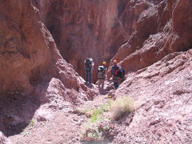
The terrain near the starting point (elevation 4470ft) is gently sloping and easily travelled. Start by hiking west and a little south, aiming to descend into the obvious shallow valley off to the northeast of the starting point. This is a minor fork of Coffin Canyon. After about 20min and 1mi you should drop into the wash at an elevation of around 4280ft. A short distance beyond this the short narrows of this minor fork begin with some small downclimbs. Then about 1hr from the start at 3620ft you will arrive at a 15ft downclimb where some may need a belay. The next obstacle is a 60ft vertical rappel where this fork meets the main branch of Coffin Canyon (36o11.77'N 116o42.39'W). For this rappel you can use a webbing wrap on the large boulder to the right of the lip. Note however that there is an easy but loose downclimb in a gully just over to the right. You should reach the main wash of Coffin Canyon at an elevation of 3390ft about 1.7mi and 90min from the start.
|
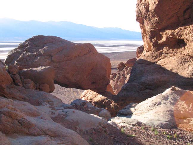
|---|
| In the upper Styx slot (Photo by Scott Smith) |
The gravel wash at this point is broad, flat and fast and you can make quick time over the next 0.5mi to thIn the upper Styx slote point 36o11.41'N 116o42.68'W and elevation 3120ft where you should find a moderate wash coming in on the right. There are several smaller gullies on the right just before this but the one you want is easy gravel travelling. Hike up the wash forking left at a junction and follow the natural runoff all the way up to Styx Saddle at 36o11.44'N 116o43.01'W and an elevation of 3380ft. You should reach this point about 2hrs and 2.6mi from the start.
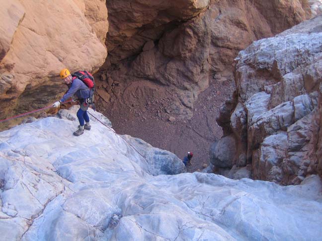
The initial descent from the saddle into Styx is quite gradual but at about 2950ft you come upon a slot in the streambed that contains four rappels one after the other and drops you into a much deeper canyon. The first rappel (which can be bypassed on the left) drops down 25ft into a narrow grotto from a large boulder anchor. This is followed by a small 10ft drop that the young may jump but can also be aided by a rope through a natural rock hole to just up on the left slope. The canyon narrows again around the corner and there you encounter a vertical 50ft rappel anchored by a chockstone and rockpile to the right of the lip. Here the canyon is only about 4ft wide and this narrow slot immediately proceeds to yet another rappel, a 40ft inclined descent from another rockpile anchor in mid-slot. The slot ends just a few yards downstream as you emerge into a deep, vertical-walled canyon at an elevation of about 2760ft about 3hrs 20min from the morning start. There are several notable sights just after you emerge. First there is a remarkable hanging cave in the conglomerate rock high on the left side of the canyon. Also it is clear that this short stretch of canyon just downstream from the Upper Styx Slot saw significant human access at some time in the past for there are the remains of a mine shaft and some old access paths on the right side of the canyon and a number of cairns that seem to mark routes into and out of the canyon at this point. Access must have been to a rdige overhead for there was no sign of travel in the canyon either upstream or downstream of this point.
 | 
| |
|---|---|---|
| >100ft sloping rappel | Winding canyon | |
(Photos by Scott Smith and Randi Poer) | ||
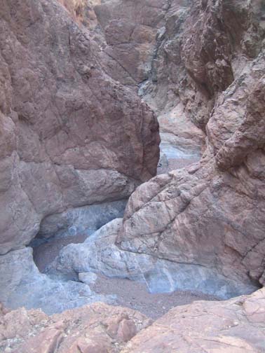
After the mine there is a long section of easy hiking down a gravel-bottomed canyon. This is interrupted at 2530ft and 3.5hrs from the start by one 40ft rappel from a rockpile anchor; here the lower 25ft of the descent is free rappel. Then the easy hiking resumes for another 45min. But the downclimbs increase in frequency. At 1760ft and 4hr 20min from the start you encounter a 30ft drop with a downclimb bypass around on the left. And 20min later at 1670ft there is a downclimb that ends with a very awkward 15ft featureless rappel slide for which there is no easy anchor. Here the best climber should belay the rest as they rappel/slide down; that climber can either friction traverse across to a good ledge on the right and/or be belayed from that readily accessible ledge. Downstream the canyon keeps narrowing and steepening with frequent downclimbs.
Roughly 5hrs from the start at an elevation of 1340ft you will come to a 90ft rappel from rockpile anchor on the right side and minutes later at 1190ft you will need to negotiate a 12ft belayed slide down smooth rock, a drop that a good climber, going last, could downclimb. This is followed 20min later at 1090ft by another awkward 10ft drop and, another 20min downcanyon at 1020ft and 5hrs from the start, by a 100ft sloping rappel from a large chockstone on the left side of the lip. The rappels and downclimbs are now almost continous and the next obstacle, 20min later at 810ft, is a small undercut 10ft drop where the last person should belay the others and then be helped down. This is followed at 680ft by a long two-step rappel in a narrow slot that needs 100ft of rope though the two drops are only 25ft and 15ft; this descent is anchored by a small chockstone behind a large boulder on the right. It is immediately followed by a 15ft belayed slide or rappel where, again, the last person who belayed the rest can downclimb the groove on the right.
 | 
| |
|---|---|---|
| Nearing the end of Styx Canyon | Hanging boulder above the last rappel | |
(Photos by Randi Poer and Scott Smith) | ||
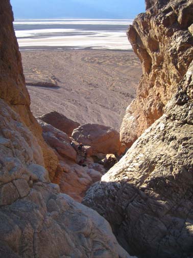
This will bring you to the top of the even steeper section of Styx just before the canyon exit. The rest of the way is a continuous series of big drops. First, at 520ft and 7hrs 15min from the start, there is a 40ft rappel down into a narrow grotto from a two piton anchor on the right side. After a short hike with several downclimbs this leads to a 80ft sloping rappel from a large boulder anchor on the right side and, just 20min later at an elevation of 250ft, to a dramatic and vertical 100ft rappel down a smooth polished groove. Here we used a combination of a rockpile anchor with a backup piton but the piton came loose and should be replaced. This is immediately followed by another 100ft rappel from a midstream boulder anchor supplemented with a rockpile.
Finally, 8hrs from the start at an elevation of about 100ft,
you will arrive at the top of the last, and perhaps the most dramatic
rappel. A huge boulder sits perched above the lip bridging the gully that
you descend. The anchor is a rock on the left side and the descent
down under the perched boulder is a dramatic experience. At the bottom
all that is left is a short friction descent to the alluvial fan. You should
reach this exit from Styx Canyon
(36o11.11'N 116o45.65'W and an elevation of
about sea level) about 8hrs 40min and 5.4mi from the start.
Hopefully you have been able to spot the return vehicle at the bottom
of the alluvial fan during the last few rappels. If so it is an easy
20min walk down the alluvial fan to the road and the car. You should
reach the car at
36o11.02'N 116o46.19'W and an elevation of
about 200ft below sea level roughly 9hrs from the start
having covered 5.8mi.
Last updated 3/10/06.
Christopher E. Brennen