ADVENTURE HIKES AND CANYONEERING
IN THE SOUTHWEST
© Christopher Earls Brennen

|
|---|

|
Hike K4. Sespe Gorge
- Hiking time: 18 hours
- Estimated hiking distance: 21 miles
- Elevation gain: Total of 2100 feet
- USGS Topo Map: Devils Heart Peak, Fillmore
- Difficulties: A very strenuous hike with up to four long swims
- Special equipment: Dry bags for all gear, 30ft of rope or webbing
-
ACA Rating: 2B VI

Characteristics
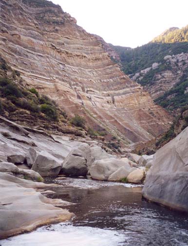
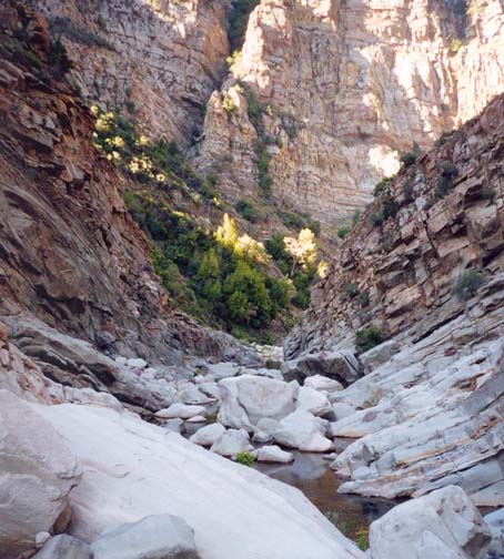
Sespe Gorge is a magnificient and towering canyon in a remote wilderness just 60mi northwest of Los Angeles. The multicoloured layers of sedimentary rock that make up this land have been fantastically twisted and tilted by the frequent earthquakes of this region and the Sespe has had to cut through these inclined strata on its way to the sea. The result is a smorgasbord of layered walls, great inclined slabs of polished rock and a canyon bottom littered with enormous purple and yellow boulders. Along one awesome stretch of about 3mi, the walls of this Gorge soar over 1000ft above you and it is almost impossible to conceive that the LA conurbation is just a few miles away. Moreover, within this inner gorge, there are three places, identifiable on the topo map, where this huge gorge becomes particularly narrow. Eric Anderson has called these the Three Squeezes, an appropriate appelation. At each of these Squeezes, the narrow rock walls have created narrow, long and deep pools. Some of these pools are over 100yds long and at least one long one at the Third Squeeze must be swum. Most people will end up making four substantial swims. Consequently, this hike requires dry bags for your gear (and for floatation).
The Sespe Gorge is at least a two day hike. The first day you should be able to complete the cross-country hike from the Dough Flat trailhead to Alder Creek, travel down Alder Creek to the Sespe and then descend the Sespe to a point just upstream of the First Squeeze. The second day you then proceed through the Squeezes, down to Tar Creek Camp from where you will hike up out of the canyon. The hike is best for a hot summer day that will allow you to warm up and dry out quickly after each of the swims. The only problem with this is that the hike up the Tar Creek trail at the end of the second day can be very hot. It may be best to camp a second night at one of the attractive Tar Creek campsites and hike out in the cool of the following morning.
Trailhead
A car shuttle is required for this adventure hike. Drive to the town of Fillmore, northwest of Los Angeles. From Highway 126 turn north on Highway 23 and proceed straight at a series of stop signs. After 1.5mi you will come to a tee-junction where you turn right though, because of the way the roads bend, you are, in effect, proceeding straight on. You are now on Goodenough Road, driving past citrus groves. After 3.7mi you reach the end of the normal road at a junction (at 34o26.91'N 118o55.35'W), where the left fork is gated private property. The right fork, the Squaw Flat Forest Road signposted 6N16, climbs steeply up the east wall of a side canyon called Little Sespe. About 2.3mi up this road you will pass a set of oil wells. Proceed straight on where a dirt road branches off to the right. Then after 3.3mi you will pass through Oak Flat where there are Forest Service structures. Again you proceed straight on where a road branches off to the right. After 4.7mi from the start of 6N16 and 20min from Fillmore, you will arrive at a broad parking area from which dirt roads go off in several directions. This is the Tar Creek trailhead (elevation 2500ft). Park the recovery vehicle here at 34o28.82'N 118o55.03'W.
In the other vehicle(s) continue along the only open road for 5.5mi and 20min to the Dough Flat trailhead at 34o31.34'N 118o53.73'W. Along the way there are several forks off to the right, but all are marked as private. Park in one of the parking spaces distributed around the trailhead loop at Dough Flat (elevation 2825ft).
Hike
From Dough Flat (elevation 2825ft) take the obvious trail that proceeds northwest up a shallow valley and then rises and falls as it transitions through several streambeds. About 1.3mi from the start you pass Squaw Spring and Squaw Flat (at 34o32.19'N 118o53.90'W and elevation 3120ft) at which point you begin a gradual climb to a pass (3690ft) about 2.4mi from the trailhead. Just beyond the pass is a marked trail junction at 34o33.07'N 118o53.93'W where you fork left (the right fork heads east toward Piru Creek) and begin a gentle descent to Cow Spring Camp (at 34o33.58'N 118o54.45'W and 3500ft) about 3.4mi from the start.
|
|---|
| Second part of First Squeeze |
From Cow Camp the trail climbs gently through a shallow trough known as the Stone Corral because of the bare slickrock ramp that defines its left side. After several small ridges (high point 3670ft) you come to an overlook and the trail drops steeply down toward the Alder Creek drainage. At the bottom of a set of switchbacks you will pass a watery little glade known as Dripping Springs (elevation 3100ft) some 5.2mi and 2hr from the start. Some further contouring and descending takes you down to Alder Creek proper where you encounter a signed trail junction. The right fork is a trail that drops down along Alder Creek from Mutau Flat and a trail system to the north. You take the left fork and travel downstream for about a mile. There you will find Alder Creek Camp (at 34o34.61'N 118o56.39'W, elevation 2530ft and 6.4mi from the trailhead), a nice, big shady camp on a bench on the right bank of the stream; it has running water most of the year. Another mile beyond Alder Camp, after a number of stream crossings, you should be alert for a place ahead of you where the canyon turns left and narrows. As you approach, the trail is following a flat bench on the right side of a broad wash. Just after some prominent rock slabs high on the right side of the canyon there is a trail junction at 2410ft, 7.2mi and 3.2hr from the start. (We took a 15min lunch break here) The established trail goes west toward the upper Sespe by continuing along this bench and then climbing up a tributary out of Alder Creek. Instead you take the left fork that crosses to the left bank of the wash and continues downstream for about 300yds to Shady Campsite (at 34o34.34'N 118o57.14'W, elevation 2400ft and 7.4mi from the start) whose precise location is not accurately shown on the topo map. Continuing on through Shady Camp it is just a few yards to the Alder Creek Narrows where the canyon flows through a narrow, vertical-walled gate. Here the trail ends and you hike off-trail down to Sespe alongside Alder Creek. At the exit from the Alder Creek Narrows, there are two sections of boulder downclimbing that can be negotiated without much difficulty. At the first section start down on the left side of the stream; then cross over to the extreme right to find a slot that drops down most easily into a knee-deep pool. At the second section of boulder downclimbing the route is all on the left side. The rest of the way to the Sespe is easy going along the streambed with, thankfully, very little brush.
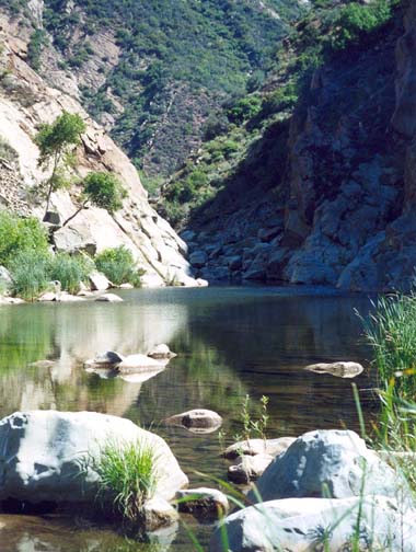
You should reach the junction with the Sespe (at 34o33.88'N 118o57.27'W, elevation 2060ft) after 4hr and 8mi of hiking from the trailhead. There is a small campsite here, the first of many small, unofficial sites that you could use on the way down through the gorge. Just downstream of the confluence is a large pool, a welcome sight on a hot summer day. It is the first of many deep pools that you will have to negotiate during your transit through Sespe Gorge. This one is easily bypassed on the left along a faint trail in the bushes.
As you begin the descent of the Sespe, the going is typical of the trailless route you will follow through the gorge, with much boulder-hopping, route finding and frequent river crossings. The river turns south and then southwest. About 1mi from the Alder you should recognize where Stone Corral Canyon enters from the northeast (at 34o33.43'N 118o56.60'W and elevation 1970ft). Here there are some beautiful waterfalls surrounded by lush vegetation. Turning south you pass another large pool after another 0.4mi.
Proceeding south about 2mi from the Alder Creek confluence, the canyon begins to narrow and the colorfully stratified left wall steepens impressively. Then, just about 7hr and 2.1mi of hiking from the start at an elevation of 1870ft, you will encounter two sets of dryfalls dropping down the left wall. The second of these dryfalls is particularly pretty with large undercutting below the harder strata. At this point about 0.5mi upstream of the First Squeeze (10.1mi and 7.3hr from the morning start) there is a nice little campsite at 34o32.59'N 118o56.74'W on the right side where we found it pleasant to spend the night.
You are now approaching the deep, central section of Sespe Gorge where route finding takes a little more time and effort. Just 0.5mi south of the campsite at 34o32.24'N 118o56.91'W and an elevation of 1840ft (10.5mi and 8hr from Dough Flat) you come to the First Squeeze, the easiest of the three narrows to negotiate. It begins just upstream of a point where the canyon turns sharp left. There are three places in the Gorge where the canyon becomes very narrow and you encounter deep and long, canyon-filling pools. They are readily identified on the topo map. You can avoid most of the water in the First Squeeze by climbing along the sloping ledges on the right side. However this strategy ends and you must descend to the water and wade through waist deep water for the last 30yds. Virtually all the big pools have muddy banks at the downstream end and these banks are good places to look for the footprints of the many animals that call this wilderness home including bear, cougar and a myriad of smaller mammals. We followed the tracks of a large bear who could not have been far ahead of us.
Midway through the First Squeeze, the canyon turns sharp left and you find yourself in an awesome gorge with great tortured and stratified walls soaring over 1000ft above you. The second part of the First Squeeze occurs just after this turn. It requires either a tricky climb onto a ledge on the right or the first swim of the day, a short 20yd refresher early in the morning. The canyon then turns right again and broadens into easier going. A little downstream you pass another large pool that is marked on the topo map.
Now every turn reveals a new, spectacular vista. About 1.8mi from the First Squeeze and 12.3mi from Dough Flat, the canyon begins to narrow again and, after a slight left turn, you come to the Second Squeeze at 34o31.09'N 118o57.21'W and an elevation of 1610ft. From the top of a readily recognized large flat rock you look down over a series of cascades to the swim at the end of the Second Squeeze. It is another awesome, majestic place and one can only wonder what it must be like after the winter storms pass through. Descending the cascades you come to the narrow rock-walled passage where you must swim about 50yds to a muddy downstream bank. You will take about 10.3hr of hiking to get to this point from the Dough Flat trailhead.
Downstream of the Second Squeeze, the canyon turns sharp right and broadens. The going is briefly easy until it turns left again and, about 0.9mi below the Second Squeeze you encounter the Third Squeeze at 34o30.67'N 118o57.76'W. Here there are two long pools one after the other. The first is about 75yds long. This is followed by an intimidatingly long pool that is at least 110yds in length. A relaxed and easy swimming style is needed here. Those who are uncertain may want to carry a swimming aid. Along the way turtles will stick their heads up out of the water to inspect your progress.
 | 
| |
|---|---|---|
| Second Squeeze from above | Second Swim in Third Squeeze |
You should emerge from the long swim at the end of the Third Squeeze after hiking for 11.5hr and 13.2mi from Dough Flat. This marks the end of the most spectacular section of Sespe Gorge. From this point on the canyon is still large but broader and often filled with huge buick-sized boulders. A short way below the Third Squeeze the canyon turns right and then sharp left at a place called Grassy Flat. A little later at an elevation of 1470ft and 5.8mi from the Alder Creek confluence, the West Fork of the Sespe enters on the right at 34o30.38'N 118o57.91'W amidst much greenery. Reportedly there is a remnant trail high on the right side that leads down from the West Fork to the Tar Creek area but we did not investigate that trail. Below Grassy Flat the canyon is still rugged and there are places where one must negotiate large boulder fields. About 0.6mi from the Tar Creek camp the canyon turns right and an unnamed stream enters on the left. The topo map also shows a group of former oil wells on the right side of the canyon at this confluence but it is hard to detect that they ever existed. About 0.3mi beyond the unnamed stream the canyon turns left and just beyond this point you encounter the only required climbing of the whole trip. A line of huge boulders fills the canyon at this point at 34o29.77'N 118o56.83'W and the only passage is on the extreme left where you climb a short way up to a slot with a 12ft vertical drop. A log has been propped up in the slot to provide some footholds. Pieces of old rope have been left by previous hikers but it would be wise to bring your own 30ft rope (or webbing) to ensure a safe and easy descent.
Beyond the downclimb, you are closing in on Tar Camp, a fact that has been evident for the last mile or so because great splotches of tar litter the canyon bottom. Some look as if they had been dropped by some tar-eating bird but all have leached out of the ground and some carried by the river. Here it is wise to begin to take special note of the following landmarks since it is otherwise not easy to locate the Tar Creek trail. Below the downclimb you will negotiate some further boulder arrays with several large campsites scattered among the boulders (some with nice streamside beaches). High above you on the right side is a prominent rock outcropping that is opposite Tar Creek and has been visible for some time. Very soon you emerge onto a notable gravel bed at the far end of which is yet another row of boulders that almost block the canyon. However this row is easily circumvented along the left shore of the stream. Just after this look for a sandy campsite with a large fireplace up near the trees. The overgrown but passable trail leads off just behind this campsite at 34o29.52'N 118o56.68'W. If you encounter Tar Creek entering on the left or the large, deep pool just upstream of the Tar Creek confluence then you should backtrack along the east bank of the Sespe. The Tar Creek trail is about 200yds upstream of the confluence.
You should come to Tar Creek Camp (elevation 1270ft) after 15.5mi and 14.6hr of hiking from Dough Flat. Large swimming holes nearby make this an attractive spot to spend the night. To prepare yourself for the steep and hot hike out of the canyon, it would be wise to rest and refresh yourself here. Be sure to filter sufficient water for the climb.
The Tar Creek trail follows the route of an old road built to service the long-gone oilwells along this part of the Sespe. Above the river, there are two long traverses first to the left and then back to the right. This brings you to a steep section littered with rockfalls before you go through a cutting in a projecting ridge. Just before the cutting there is a good but partial view of the big waterfall in Tar Creek. Beyond the cutting the trail climbs and then descends to cross Tar Creek. It should take 2hr to climb the 3.1mi from the Sespe to the Tar Creek crossing and another 1hr to hike the 2.5mi back to the Tar Creek trailhead (at 34o28.82'N 118o55.03'W and elevation 2500ft) and the recovery vehicle.
The total length of the hike is just over 21mi and it should take the strong hiker a total of about 18hrs of travel to cover.
Last updated 18/6/03.
Christopher E. Brennen