ADVENTURE HIKES AND CANYONEERING
IN THE SOUTHWEST
© Christopher Earls Brennen

|
|---|

|
Hike A3. West Fork of Oak Creek
- Hiking time: 13 hours (full descent)
- Estimated hiking distance: 12 miles (full descent)
- Elevation gain: Minimal
- USGS Topo Map: Wilson Mountain, Dutton Hill, Munds Park
- Difficulties: About 6 swims and extensive wading, some bushwhacking
- Special equipment: Neoprene wetsuit except perhaps in high summer; water filter
-
ACA Rating: 1B IV
 (full descent)
Characteristics
Sedona with its majestic rock monuments and red cliffs is a popular tourist destination south of Flagstaff, Arizona. Between those two cities a two-lane road winds its way through the spectacular Oak Creek gorge, some thousand feet deep with red and white rock walls, a beautiful river and a forested canyon floor. This is high desert country some 5000-6000ft above sea level and so substantially cooler than the lower, parched deserts to the south. About halfway along the highway route through the gorge, another great canyon joins from the west, the West Fork of Oak Creek. Only a walking trail penetrates this canyon and then only for a few miles. Here we describe two adventures in the West Fork.
The first is an easy adventure that takes you up into the canyon from the bottom, hiking first along the trail up the West Fork. The trail ends after about 3mi; you can then explore the gorge beyond the end of the trail to the extent of the time and energy available. Moreover, this easy hike is recommended for any time of the year. In the summer, the elevation and the shade from the high canyon walls moderate the heat and allow wading in places where the alternatives are difficult. In winter, snow may add another tinge of beauty to the canyon but also freeze the river making passage more difficult in places.
The second is a demanding descent of the entire length of the West Fork which requires a fairly long car shuttle through Flagstaff. Though non-technical this descent traverses some rugged canyon bottom with a number of swims and innumerable wades. Because of this immersion it is recommended for the summer only. In winter, snow banks in the higher reaches make passage difficult and when frozen the deep pools can be dangerous.
Trailhead
Parking at the end of the West Fork of Oak Creek is at the regulated West Fork Trailhead (34o59.44'N 111o44.57'W) about 11mi north of Sedona beside Highway 89A in Oak Creek Canyon. At the time of writing the parking fee is $5.00, and you should make sure to go with correct change for the parking lot is only attended part of the time. Inform the parking attendant when leaving a vehicle overnight for the full descent hike and he/she will mark your parking sticker appropriately. Note also that the parking lot has a gate that, reputedly, is locked at 8pm. This places a significant constraint on the timing of the full descent hike.
If embarking on the full descent, then after depositing the recovery vehicle, drive north to Flagstaff on Highway 89A, which joins Interstate 17 for the last couple of miles. Crossing Interstate 40, continue on Highway 89A North and drive about 1.5mi through a fast food and motel area of Flagstaff to the intersection with Route 66. Turn left onto Route 66 and drive about 1.8mi out of town to the left turn onto Woody Mountain Road. For reference check your odometer here; it is 18mi from here to the trailhead in the West Fork of Oak Creek. The road crosses back over Interstate 40 (no ramps) and, shortly thereafter, becomes Forest Road FR231, a well-graded dirt road. Basically you proceed straight on the dirt road all the way to the West Fork though the surface becomes a little rougher further along. There are one or two places where you might take the wrong fork but the main route is always straight on and obvious and there are occasional small FR231 signs to reassure you. After 6mi you come to Rogers Lake and pass around its south shore. After 14.5mi you begin a gradually descent into the Cassner Cabin Draw valley, crossing the stream via a narrow concrete bridge at 15.5mi. A sign identifies Cassner Cabin Draw. The road then climbs out of Cassner Cabin Draw and immediately begins a descent into the drainage of The West Fork of Oak Creek, which it crosses by means of a concrete bridge after 18mi. There are small pullouts before and after the bridge in which to park your vehicle (35o2.01'N 111o51.35'W). To get an early start the next morning, it is a good idea to camp here the night before; there is a broad flat area beside the stream and just below the bridge. Here signs warn of the lack of any trail downstream.
Out and Back Hike from the Bottom
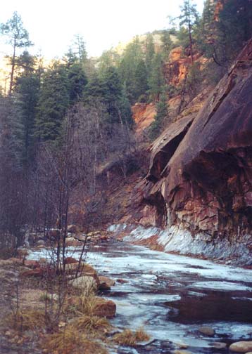
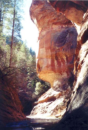
From the trailhead (elevation 5300ft) follow the indicated West Fork trail that proceeds southward and soon crosses to the west bank of Oak Creek itself via a footbridge. After another 0.2mi you come to the ruins of a homestead at the junction of Oak Creek and its West Fork. The homestead was constructed by Mayhew Lodge around the end of the 19th century but has been long abandoned. The ruins include the outline and chimneys of the main house, some outbuildings and a smokehouse(?) made from a cave in the wall of the canyon. Turning right here the trail enters the West Fork of Oak Creek with towering walls of red and white rock on both sides. The red rock lower down is Coconino sandstone and the higher white rock is Kaibab limestone.
 | 
| |
|---|---|---|
| Near the mouth of the West Fork | About a mile up the West Fork |
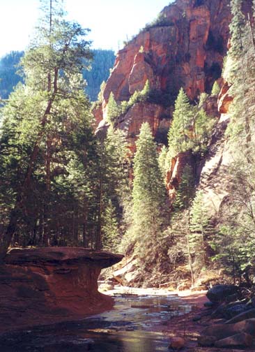
This is a very popular and well travelled trail with a beautiful year-round stream that has carved a rounded channel in the soft red rock. In places the channel has substantial overhang on one or both sides and resembles the subway-like channel found elsewhere in the southwest, notably in Zion National Park. The canyon floor is heavily wooded with Ponderosa pines and Douglas firs making for one beautiful scene after another as you follow the trail upstream. I did this hike just after Christmas when patches of snow remained from the last storm, the river was frozen in many places and icicles hung from the canyon walls. The trail is well worn and easily followed but with many stream crossings. Except after rain, the stepping stones at these crossings allow dry passage though a hiking stick would be useful.
About 50min from the start you pass the 1.5mi marker (elevation 5340ft) and about 45min later the trail climbs onto a high bench on the left side of the canyon to bypass a channel filled with water. The trail ends when it drops down again to a boulder strewn canyon floor at a point about 3mi and 1hr 40min from the start of the hike. Here the channel in a subway-like channel is filled from wall to wall with the stream. To progress further in the summer it is necessary to wade about 50yds upstream to where one can again find dry passage to one or other side of the stream. It would be useful to bring sandals and a small towel to make this passage comfortably. In the winter, the pool may be frozen over making passage difficult.
Upstream of the subway narrows, the channel continues narrow and spectacular with huge red-rock bluffs on both sides. There are many overhangs some creating caves that would make great camping sites except that camping is prohibited within six miles of the trailhead. The stream itself continues to be shallow and gentle though there are some deep pools along the way. Though there is only a faint use-trail, the going is easy and fast thanks in part to the flat red-rock streambed. About 4.5mi and 2.5hr from the start, a large canyon enters from the south. Turn around when time and energy suggest it.
Through Hike
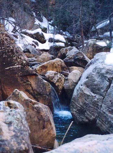
Just downstream of the FR231 bridge over the West Fork (35o2.01'N 111o51.35'W, elevation 6500ft), there is a use-trail alongside the stream but this soon peters out as the valley deepens and the brush increases. This upper part of the canyon is pleasant though not spectacular and slow going. After 1hr 40 min and 1.5mi you come to a junction (35o1.30'N 111o50.35'W, elevation 5930ft) with a large canyon entering on the right that adds significantly to the stream flow. However, the going here remains slow and it takes another 90min to come to the next large canyon junction where Cassner Cabin Draw comes in on the left at 35o1.48'N 111o49.79'W and 5800ft. Just before this junction you will encounter the first of many narrows; here there were two thigh-deep wades during our descent. You should reach the Cassner Cabin Draw junction, about 2.4mi from the start after 3hr of hiking.
|
|---|
| In the upper West Fork |
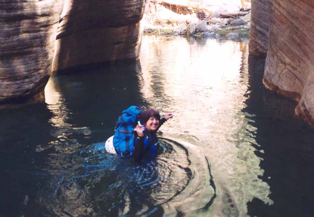
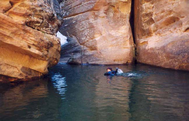
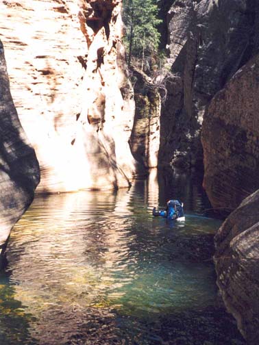
The toughest part of this adventure lies just beyond the Cassner Cabin Draw junction where there are a series of narrows each with its own wet challenge. Since these hurdles change with time and with the season this account can only give a rough idea of their character. Just 20min beyond Cassner Cabin Draw, there is a narrows with a chest deep wade and shortly thereafter you come to the first swim. This is a good place to don your neoprene, probably essential except during the height of summer. The first swim is only about 20yds; the second follows shortly and is longer, about 40yds, and blind though it can also be bypassed via a slot on the left. Three more substantial wades follow quickly. Then, about 4hr 40min from the start at an elevation of 5700ft you come to a longer swim/wade through a narrow straight slot about 60yds long. Then the going eases and there are no narrows for a substantial time.
 | 
| |
|---|---|---|
| The first swim | The second, optional swim |
You are now deep within the confines of Oak Creek Canyon with high, rugged walls all around. It is hard to know exactly where you are on the topo map but there is little need for the way is clear. Then, unexpectedly, at 5600ft and roughly 7hrs from the start, the canyon narrows again and you encounter a 100yds long, narrow, water-filled slot whose end cannot be seen from the start. In the summer, you might enjoy this swim. However, there is also a sketchy, high bypass trail on the right that descends to the dry downstream bottom via a steep gully. Below this point there are so many wades that one stops counting for often the easiest route is in the stream. However, the going gets easier and faster for there is relatively little bushwhacking and frequently the flat bedrock provides for fast passage. Several small canyons enter on the left. Then at 5440ft and 9hrs 20min and 6.8mi from the morning start, you arrive at the junction with Barney Spring Canyon (35o0.76'N 111o46.94'W) that enters on the right. The West Fork is now a spectacular gorge with great red and white sandstone walls, convoluted and dotted with greenery. The streambed itself often runs in channels reminiscent of redstone subways and sometimes with undercuts on both sides. Hopefully you started this hike early enough and with enough reserves to enjoy this remarkable place.
 | 
| |
|---|---|---|
| The 60yd swim/wade | Just before the last subway |
Just when it seems as though the swimming is far behind you, you will arrive
10hrs 20min from the start at an awkward, short narrows with a
deep slot on the right and a shallow shelf on the left. Trouble is that
shelf was so slippery when we came through that we ended up having to swim.
About 1hr later and 11hrs 20min from the start, you will
come to a lovely long subway with a shallow wade. Curving to the left, this
brings you to the start of the established trail that climbs up onto a
bluff on the right for easier passage. The trail crosses the river perhaps
8 to 10 times but provides very easy hiking as described earlier. We
reached the carpark
(34o59.44'N 111o44.57'W and an
elevation of 5300ft) about 13hrs after
the morning start having covered 12mi of rough but spectacular
canyon.
Christopher E. Brennen