ADVENTURE HIKES AND CANYONEERING
IN THE SOUTHWEST
© Christopher Earls Brennen

|
|---|

|
Hike G8. Natural Bridge Canyon, Death Valley
- Hiking time: 8 hours
- Estimated hiking distance: 3.5 miles
- Elevation gain: 2740ft
- Topo Maps: Devils Golf Course, Ryan
- Difficulties: Long, steep approach climb, about 11 rappels up to 100ft, much downclimbing
- Special equipment: 200ft rope, 40ft webbing, rappelling equipment, including helmets
-
ACA Rating: 3A III

Characteristics
Death Valley National Park contains some of the most rugged and fantastic landscape in the world and provides some marvellous adventures and canyoneering experiences. Though the heat in the summer is intolerable, the Park has the advantage that the mild winter weather allows outdoor activity when much of the rest of the southwest is too cold and wintery. While it does occasionally rain in the valleys and snow often covers the high peaks in the winter, at lower elevations the temperatures are perfect for exploring the many narrow, multicolored canyons that line both sides of the flat valley bottom. This collection of adventures contains many in Death Valley National Park.
There are many exciting canyoneering adventures that begin at Dante's View in the Black Mountains and drop up to 6000ft down to the Badwater Basin. Many of these are best done by placing a return vehicle at the bottom along the side of Highway 178 and using a car shuttle to Dante's View. Most of the Black Mountain canyon descents described in this collection are best done this way. Some, however, would require a long traverse from Dante's View to the canyon head and are therefore more easily done as loop hikes with an initial ascent from the valley. This descent of Natural Bridge Canyon is one of these. It also features a visit to the popular Natural Bridge at the end of the hike.
Trailhead
This hike does not require a vehicle shuttle but is, instead, a loop hike with a long, steep approach hike. Park at the Natural Bridge Canyon trailhead by driving south from Furnace Creek on Highway 178 for about 13.5mi (or about 3.5mi north from Badwater) to the signed turn-off for Natural Bridge. Then drive 1.5mi up the dirt road to the Natural Bridge trailhead and park. Here the adventure begins and ends at 36o16.878'N 116o46.189'W and an elevation of 350ft.
Hike
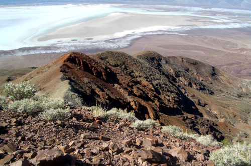
From the Natural Bridge parking lot (36o16.878'N 116o46.189'W, elevation 350ft) look due south at the ridges along the base of the Black Mountain range. You should see two darker, red-brown ridges, one which is a large lump and another, nearer one that is flatter and lower. Hike across the flat but descending alluvial fan to the bottom of the lower, red-brown ridge at 36o16.523'N 116o46.092'W (160ft elevation). From there turn east and begin the long, steep ascent of this lower red-brown ridge. You follow the apex of this ridge, first hiking up a gravel-coated ridge and then transitioning onto rougher red-brown and orange rock. Continuing the steep climb, you encounter several small steep sections that require class three climbing and some route finding. As long as you stay on the apex you should reach the top of the initial steep climb about 2.5hrs from the start. This intermediate summit at 36o16.630'N 116o45.200'W and a elevation of 2320ft) can be identified by the wire and posts of an old fence lying on the ground. The view from this vantage point is magnificient, south to the great salt lake expanse of Badwater, north over chocolate and red-brown hills toward Furnace Creek and West to the Panamint Range and the snow-covered Telescope Peak. Behind you to the east the Black Mountain range continues to rise with Dante's View out of sight and above you to the southeast. The climb may be arduous but it is richly rewarded.
|
|---|
| The ascent ridge from above |
A series of knolls or bumps range off to the immediate east south east. The route continues along the apex of the ridge now ascending this series of three or four knolls with small flat sections or minor descents in between. It culminates in a final steep ascent to the top of the last knoll, the highpoint of the loop-hike at 36o16.645'N 116o44.880'W and an elevation of 2870ft. You should reach the top of this steep approach climb about 3hrs from the start having climbed 2740ft.
From this highpoint, you should see a saddle below you to the east (there is also one to the north-east) and the route lies down a slope of loose gravel to that eastern saddle at 36o16.665'N 116o44.791'W. Immediately to the left or north of this saddle is the drop-in to the south fork of Natural Bridge Canyon. The drop-in at 36o16.696'N 116o44.697'W and an elevation of 2750ft is short and easy; you should reach this point about 3hrs 15min and 1.7mi from the trailhead. There is a short, steep drop at the start that is easily bypassed on the left.
 | 
| |
|---|---|---|
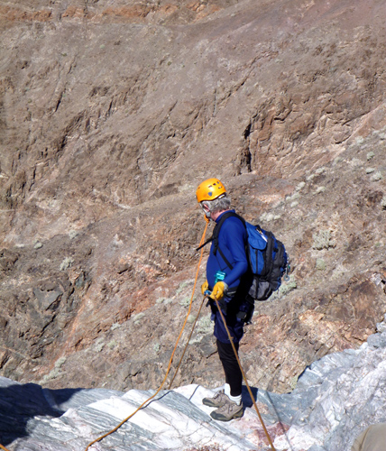
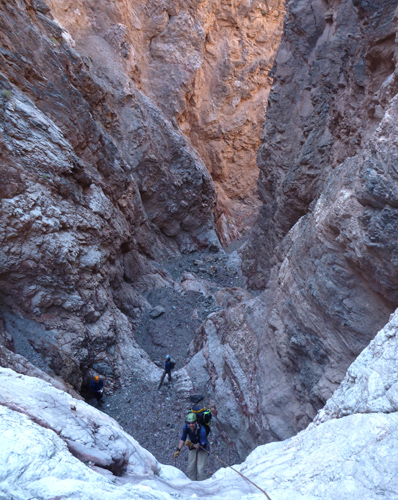
| The author at the top of the second rappel | In the lower canyon | |
(Photos by Alicia Allen) | ||
As you begin your descent of Natural Bridge Canyon, you proceed down canyon for about 200yds before encountering a moderately long section with small drop-offs. It is most convenient to bypass this section on the left though it can also be bypassed on the right. The bypass shelf on the left has an obvious point at which to descend again to the canyon bottom. From there it is a short distance to the top of the first rappel, a 30ft drop from a rock-pile anchor at 36o16.809'N 116o44.830'W and an elevation of 2440ft. You should reach the first rappel about 4.5hrs and 1.7mi from the morning start.
This first rappel is followed by a series of three modest 20ft downclimbs before you arrive at the top of the second rappel at an elevation of 2170ft. This second rappel consists of an 80ft drop from a deadman anchor; from the top there is a great panoramic view of the canyon below. Just a short distance downstream there is a rappel or downclimb of about 20ft that is perhaps best anchored by a good climber who can downclimb as the last descender. The rappels and downclimbs are now closely spaced and it is but a short walk to a 100ft sloping rappel at 36o17.014'N 116o45.053'W and an elevation of 2020ft. This is perhaps the longest descent in the canyon and is supported by a deadman anchor. Immediately below it is a downclimb/rappel of 25ft, then a short walk to another 20ft downclimb/rappel followed by yet another 15ft downclimb/rappel at an elevation of 1860ft. It should take a little less than 5hrs to reach this point.
It is but a short distance down canyon to the next series of rappels at an elevation of 1800ft. This consists of an 80ft rappel from boulder anchor immediately followed by a 65ft rappel from a deadman anchor and, a little further on, a 20ft downclimb through a slot on the right. Just below this you come at an elevation of 1710ft to a 60ft rappel from rock pile anchor. This rappel follows an awkward inclined slot; it may be wise to take off your backpack for this one otherwise it gets hung up on the ceiling of the slot. Just downstream is a large rock mass in the middle of the canyon that you bypass on the right. A short hike down canyon brings you to a 20ft vertical drop that can be bypassed using a broad ledge on the right. Just beyond this is a 20ft rappel from big boulder anchor. This difficult rappel has a very awkward entry with a large overhang where care is needed to avoid a dangerous pendulum underneath. This is shortly followed by a 20ft rappel from a rock pile anchor and another short hike.
 | 
| |
|---|---|---|
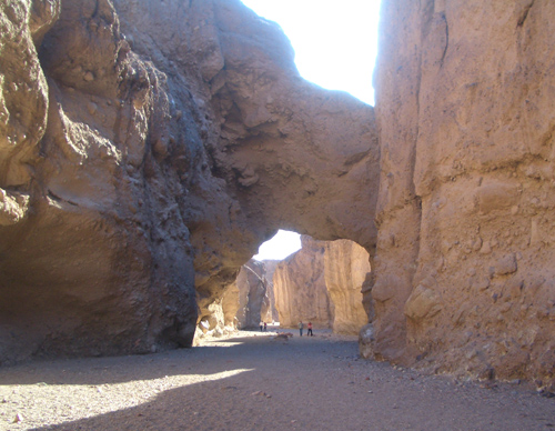
| Approaching the natural bridge (Photo by Alicia Allen) | Natural Bridge |
You should reach the next rappel at an elevation of 1120ft a little more than 6.5hrs of hiking from the morning start. This consists of a 75ft rappel from a rockpile anchor with a small but awkward overhang near the top. The walls close in here and you descend into a half cave. A little easy hiking brings you to the top of an 80ft rappel from a big boulder anchor and then a readily recognized 30ft rappel from a rockpile anchor. This proceeds around a huge canyon-filling boulder and has an awkward entry with a big overhang. A short distance downstream you come to the last rappel at 36o17.194'N 116o45.662'W and an elevation of 800ft after about 7hrs 15min of hiking. This is a simple 20ft descent from a rockpile anchor and is readily recognized by the old piton in the left wall (still part of the anchor!).
Down canyon from this last rappel there are obvious signs of upstream travel. After a few easy downclimbs, the
canyon begins to broaden and, in the afternoon sun, there are some
beautiful vistas of the red canyon walls. Now it is easy gravel hiking
and, rounding a broad left turn, you get your first view of the canyon-spanning Natural Bridge at
36o17.083'N 116o45.951'W and an elevation
of 600ft. You should reach this point about 3.1mi from the start after about 7.5hrs of hiking.
The Bridge itself looks quite temporary with large cracks in the loose conglomerate rock of which it is
composed. Beyond the Natural Bridge it is an easy 10min hike to the end of the canyon and the trailhead
parking area (36o16.878'N 116o46.189'W, elevation
350ft). Overall the 3.5mi hike takes about 8hrs.
Last updated 3/17/2011.
Christopher E. Brennen