ADVENTURE HIKES AND CANYONEERING
IN THE SOUTHWEST
© Christopher Earls Brennen

|
|---|

|
Hike K2. Little Mutau Creek
- Hiking time: 6 hours
- Estimated hiking distance: 9.2 miles
- Elevation gain: 1710 feet
- USGS Topo Map: Lockwood Valley
- Difficulties: None
-
Special equipment: None
Characteristics
The Little Mutau Creek Trail is a remote wilderness trail in the Sespe Wilderness in Ventura County. The trail connects the Johnston Ridge Trail (20W12) and the Alamo Mountain Road (8N01.3). Little Mutau Creek flows westward from Alamo Mountain to drain into Mutau Creek.
Trailhead
One of the few roads that accesses this remote wilderness wanders down from the north to the end at the parking area at the north end of Mutau Flats at 34.64142oN 119.05284oW and an elevation of 4908ft. The expansive ranch land to the south was once used as a cattle grazing area by local pioneers. Because of its remote location it is said to have once been a holding area for cattle rustlers and horse thieves. The property is now in private hands and not accessible to the public.
The Mutau Flats parking area and trailhead (34.64142oN 119.05284oW and elevation 4908ft) is just on the north side of the large grassy area known as Mutau Flats. It provides access to the Stonehouse Trail (20W35), the Johnston Ridge Trail (20W12) and the trail we decribe, the Little Mutau Creek Trail (20W10).
Hike
From the parking area at 4908ft, hike down the Johnson Ridge Trail (20W12). After crossing the Creek about 1.1mi from the start you begin the ascent up a valley along Little Mutau Trail. About 1.8mi from the start you arrive at the junction (4800ft) with Johnston Ridge Trail at 34.63503oN 119.03220oW and an elevation of 4950ft. A right turn here would eventually take you to the Sespe Hot Springs along that trail. We proceed straight on along the Little Mutau Creek Trail, cross over a motorcycle barrier and climb for about 1.4mi to a summit at 34.63873oN 119.01768oW and 5729ft.
At approximately the 4.6mi mark at about 34.63685oN 118.99932oW and an elevation of 5223ft you come to the Little Mutau Campsite. Near here you reach a point where you would leave the main trail for an ascent of San Rafael Peak (34.62394oN 119.00187oW and a height of 6642ft).
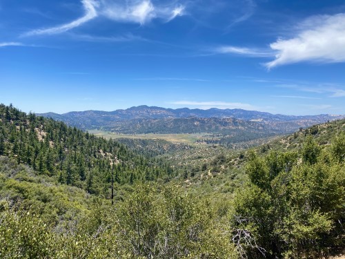
|
|---|
| Looking back to Mutau Flats (photo by Antonio Calderon) |
Unexpected Turnaround
I had reached a point about 34.63685oN 118.99932oW roughly 4.6mi from the start when a most unexpected series of events caused me to retreat. As I was crossing the Little Mutau Creek I came upon the body of a large, dead black bear lying in the shallow creek. Once I had overcome my surprise and shock, I edged closer for a better look. The bear appeared to have been shot and at least partially decapitated. It was clear that the bear had been dead for perhaps days. I was not sure what to do and regretted I had not brought my camera. Seeing that there was little I could do, I edged past the bear and proceeded a little further east along the ascending trail. Suddenly I heard noises above me on the slope on my left and a bear cub came tumbling down the slope onto the trail ahead of me. The cub paused to view me and then began to creep forward. As I had done during previous bear encounters in the High Sierra, I stood high and yelled at it. At which point the cub retreated and climbed a short way up a large pine tree to my left. I backed up slowly, and much shaken by the events, retreated backwards down the trail. Indeed once I determined that the cub was not following me, I hastened all the way back to my car in the Mutau Flats parking area.
In the days which followed I thought about what I should have done. Report the incident?
I suspected the cub could not survive without help. In the end I did nothing but have always felt guilty about my lack of action.
Christopher E. Brennen