ADVENTURE HIKES AND CANYONEERING
IN THE SOUTHWEST
© Christopher Earls Brennen

|
|---|

|
Hike A4. James Canyon and Pumphouse Wash
- Hiking time: 7.5 hours
- Estimated hiking distance: 5.5 miles
- Elevation gain: None
- USGS Topo Map: Mountainaire
- Difficulties: Two rappels of 20ft and 40ft and a number of swims, one 70yd long
- Special equipment: Rappeling equipment, 100ft rope, 30ft webbing, 2 rappel rings, dry bag, wicking clothing and a warm jacket for downstream of the swims
-
ACA Rating: 3B III

Characteristics
About 15mi south of Flagstaff, Arizona, the rolling and forested high mesa is cut through by a network of canyons that deepen and combine to form the magnificent 1000ft gorge known as Oak Creek Canyon. This empties out to lower elevations just north of Sedona, Arizona, where the red and white sandstone cliffs and bluffs that the water force has created culminate in the spectacular vistas that make Sedona such a tourist attraction. This adventure explores one of the principal canyons at the headwaters of Oak Creek Canyon. Starting on the high mesa the route descends through James Canyon to where it empties into Pumphouse Wash and then follows the latter down to the head of Oak Creek Canyon.
The route descends through various layers of sandstone each of which produces its own sculpted canyon scenery adorned with lovely pine forest. There are two modest rappels of 20ft and 40ft, the former being the more difficult because of the swimming disconnect. More challenging are the many deep pools that must be swum, one about 70yds long. These require a dry bag that can also be used as a flotation device. Note that the length and number of swims will vary with the time of year and the recent weather. I recommend you do this hike in mid-summer though, even then, the pools are cold. Bring a warm jacket to wear after the swims.
Trailhead
This adventure requires a car shuttle. To deposit the return vehicle drive about 14mi south from Flagstaff, Arizona, on Highway 89A. At the bottom of the switchbacks that descend into Oak Creek Canyon, leave the return vehicle close to the small bridge over Pumphouse Wash (35o1.51'N 111o44.14'W). Parking here is very limited and you should note that a a Red Rock Parking Pass is needed to park anywhere along the side of Highway 89A in Oak Creek Canyon. Parking Passes can be obtained at a number of small markets in the canyon.
Having parked the return vehicle, drive north again on Highway 89A, pass the Oak Creek Canyon Scenic Overlook on the east side of the road and, 1.2mi north of the Overlook, turn right onto Forest Road FR237 at 35o3.27'N 111o43.97'W. This good dirt road winds through the forest for about 4.5mi and meets Interstate 17 at exit 333 where there is a Union 76 gas station and food mart. Then drive south on Interstate 17 for 2.7mi and leave the Interstate again at Exit 331, the Kelly Canyon Road offramp. Park by the side of the asphalt offramp (35o3.13'N 111o41.05'W and an elevation of 6750ft).
Hike
A barbed wire fence parallels Interstate 17 just down a short slope from the offramp. The hike to the drop-in to James Canyon proceeds south along a rough dirt road on the far or west side of that fence; the road soon veers west. You may choose to drive down this rough dirt road for about 0.5mi and park in the forest. In either case, turn left off the dirt road after about 0.5mi and hike south following any one of several small drainages that soon drop down (35o2.72'N 111o41.21'W) into James Canyon. You should reach the shallow canyon bottom (elevation 6500ft) about 30min from the start.
|
|---|
| Keyhole Falls from below |
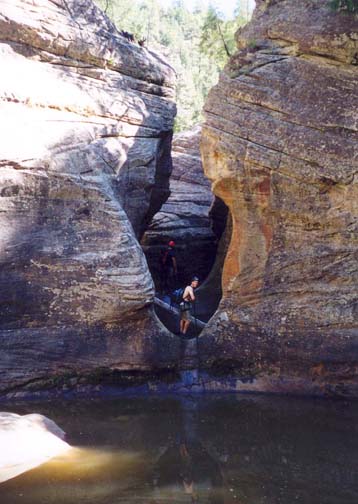
In its upper reaches James Canyon is a lovely pine-forested glen in which the stream cuts through the Coconino sandstone layer via a series of small waterfalls, each of which has a large deep pool at its base. You encounter the first of these waterfalls after just 5min of hiking in the canyon. A 10ft drop through a narrow rock gate leads to a large deep pool that would require swimming. However, this first hurdle is easily bypassed using a use-trail on the right that climbs briefly and then descends again to the streambed downstream of the pool. Another 30min of hiking brings you to the first technical obstacle, the complicated Keyhole Falls (35o3.00'N 111o42.28'W). Using a combination of wraps around a log and a large rock, you rappel down about 20ft into a small but deep and cold pool where a swimming disconnect is needed. Often there are logs floating in this pool and these add to the difficulties. However, it is only a few yards across the pool to a sandstone lip that leads to a 4ft drop into a small circular pool contained in a gateway between narrow sandstone walls. Descend into this 4ft deep pool and climb onto the lip at the far side where a second 6ft drop leads into a large, wide pool. A 25yds swim across this pool takes you to the broad shore downstream of the obstacle at an elevation of 6350ft; you should reach this point 1hr 20min from the start.
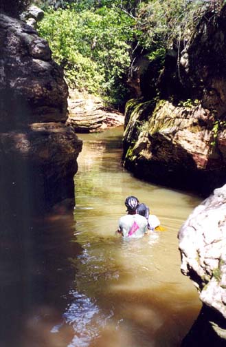
More deep pools follow. About 20min downstream of Keyhole Falls there is a deep wade through a narrow pool in a slot and, 30min later, you encounter a section I call the Twisted Narrows where the watercourse weaves back and forth between narrow rock walls. Here there are two small downclimbs each measuring about 6ft in height and each followed by a small but deep pool that must be swum. Then the going eases for a while allowing you to enjoy the loveliness of this verdant canyon and the contrast between the greenery and the bright sandstone outcroppings.
 | 
| |
|---|---|---|
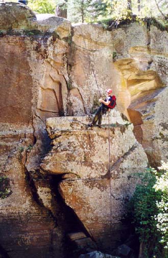
| One of many James Canyon swims | James Canyon 40ft rappel |
Approximately 1hr downstream of the Twisted Narrows, you arrive at the top of the last technical obstacle in this hike, a vertical 40ft drop down a cliff beside a large rockbound pool. You should reach this point about 3hr 20min after starting out. The anchor for the rappel is a large tree on the left side and this leads to a dry landing on the left bank of the pool. Downstream of the 40ft rappel the canyon deepens and narrows significantly. After about 1hr, you encounter a most unusual obstacle, a long 8ft wide slot between towering vertical walls. It is about 70yds long, filled with deep, cold water and involves a long and tiring swim. A short distance down canyon there is a shorter swim through another rockwalled gate. Beyond this James Canyon broadens and mellows and you hike the normally dry streambed all the way to the end where it joins Pumphouse Wash. You should reach this junction (elevation 6090ft) about 5.5hr from the trailhead having covered 3.3mi mostly through James Canyon.
The junction of James Canyon and Pumphouse Wash (35o2.60'N 111o43.22'W) is a wide boulder-strewn flat and the next 0.5mi of Pumphouse is quite broad and meandery. You encounter a number of large pools, all of which are easily bypassed. Then, about 50min below the junction, the Wash descends to a sandstone layer and the bed becomes sculpted slickrock, fun to walk on (35o2.16'N 111o42.94'W). Here there are lovely swimming holes, one called The Rectangle because of its regular shape. Then the Wash makes a sweeping right turn and you encounter the first of a number of deep slots where the stream has cut into the sandstone bed in the otherwise broad bottom of the Wash. Do not descend into these slots unless you feel adventurous. In all cases it is possible to bypass the slot and the pools it contains by using the ledges on the left side. These ledges lead to easy downclimbs beyond the slots and pools. Some of those pools make for excellent swimming on a hot day.
Gradually the larger canyon narrows, the inner slots disappear and
you must negotiate your way through the boulder fields that comprise the
canyon bottom for the last mile or so. In one or two places the walls
close in to a width of about 15ft and in those narrows there may
be pools that must be swum, or, at the very least, waded.
Nearing the end you will
begin to hear the vehicles in Oak Creek Canyon and shortly
thereafter the road bridge that crosses Pumphouse Wash comes into view.
Climb up to the road via the use-trail on the left. You should
reach this terminus
(35o1.51'N 111o44.14'W and
elevation 5680ft) roughly 7.5hr after the
morning start having traversed 2.8mi of James Canyon, 2.2mi of Pumphouse
Wash, and a total distance of 5.5mi.
Christopher E. Brennen