ADVENTURE HIKES AND CANYONEERING
IN THE SOUTHWEST
© Christopher Earls Brennen

|
|---|

|
Hike L3. Harris Point, San Miguel Island
- Hiking time: 3.5 hours in a 4 day expedition
- Estimated hiking distance: 6.2 miles
- Elevation gain: 400 feet total
- USGS Topo Map: San Miguel Island East
- Difficulties: Access: hike must be accompanied by a ranger
- Special equipment: Binoculars
Characteristics
San Miguel is the westernmost of the Channel Islands and part of the Channel Islands National Park in the Santa Barbara channel. It is a remote and wild place where you can only hike if guided by the Park Ranger. Three hikes on San Miguel are listed in this collection and, though guided, qualify as adventure hikes because of the unique destinations and the adventure involved in getting to the island and camping there.
The island consists of a relative flat plateau ringed by coastal bluffs and cliffs. Until about 40 years ago, the island had been almost denuded of vegetation by the sheep that were raised on the island. The result was that much of the island was covered in driven sand blown in by the prevailing northwest winds. In the intervening 40 years much of the island has recovered some vegetation though there are still some sand-blown areas. There are, however, almost no trees and the island is largely covered by grass and low bushes. Unlike the neighbouring islands to the east, San Miguel is not sheltered from the northwest winds by Point Conception and the mainland. Consequently the weather is rather different, being either foggy or windy.
This hike to Harris Point is one of the most scenic on the island.
Trailhead
A concessionaire, Islandpackers, runs ferries to all four of the islands of the Santa Barbara channel, which, reading from east to west, are Anacapa, Santa Cruz, Santa Rosa and San Miguel. Their headquarters and principal port of embarkation are a jetty next to the visitors center at Ventura Harbor. They operate roughly 10 visits a year to San Miguel with, typically, an outbound trip on Friday and the return journey on Monday. The ferry usually makes stops at Santa Cruz and Santa Rosa on the way to San Miguel and it therefore takes about 5hrs to get to San Miguel. There are no accommodations on the island other than the campground so one must come prepared for rough camping for two or three nights. Because of the wind and fog, camping is rather more challenging than usual in Southern California. The lone campground has sites that are equipped with windbreaks (as well as food-boxes and tables). Moreover, there is no water available so that campers must bring their own from the mainland. Camping reservations must be made with the National Park before booking passage to the island.
Unlike the other islands, there is no jetty at San Miguel and the landing is an adventure in itself. The ferry anchors in the sheltered bay called Cuyler Harbor and then, aboard a Zodiac, passengers are ferried, six at a time, through the surf to the pristine beach that lines the bay (34o2.83'N 120o21.06'W). Packs and other camping gear (including water) are similarly landed. Don't be surprised if a group of elephant seals are sunning themselves on the beach beside where you land!
From the beach, a steep trail ascends the coastal bluffs by climbing up the side of Nidever Canyon just inland of the landing point. Climbing out of the canyon onto the island plateau the trail heads east to a small saddle where the campground is located, at 34o2.45'N 120o20.95'W), an elevation of 490ft and 0.7mi from the beach.
Hike
The ranger-led hike begins in the campground (elevation 490ft) and starts down the trail toward the beach. Just after entering Nidever Canyon you will come to a trail junction, 400yds from the campground, whose only signs point up the way you have come. Leave the beach trail her and, forking left, proceed up canyon for about 70yds to the site of the first ranger station and the current water-pumping system. Here the trail crosses the streambed and proceeds downcanyon again, climbing over a bluff and descending into another branch of Nidever Canyon. Here you are close to the almost vanished remains of Nidever's old adobe homestead. Dropping down yet again to cross a third branch of the canyon, you then climb to the edge of the high bluffs overlooking Cuyler Harbor. You should reach this overlook (34o2.82'N 120o21.53'W and elevation 420ft) about 40min after leaving the campground having covered about 0.75mi.
|
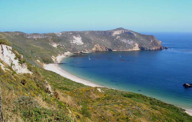
|---|
| Cuyler Harbor from bluffs |
The view from this overlook is marvellous. The entire length of Cuyler Harbor beach stretches out below you, shimmering in the sun (hopefully!), while Prince Island stands guard over the entrance to this natural harbor. Below you are likely to see elephant seals basking on the beach and seals frolicing in the surf. It is a pristine seascape almost unmarked by man.
 | 
| |
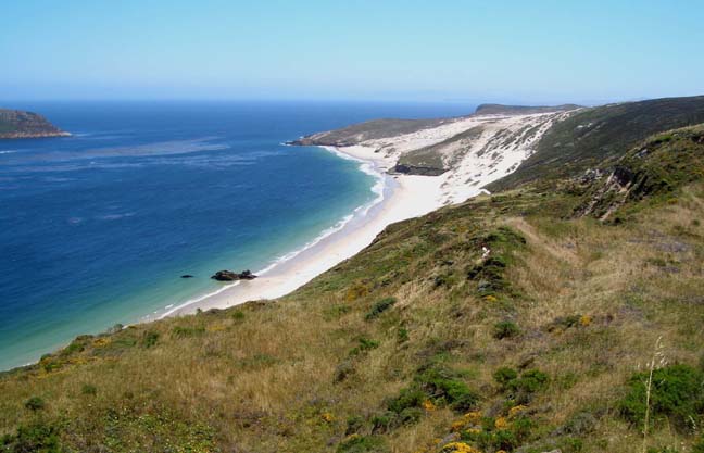
|---|---|---|
| East end of Cuyler Harbor beach | Secret Cove from Harris Point |
The trail proceeds along the edge of the bluffs for a short distance before veering inland and climbing gradually over the grassy plateau. Eventually you surmount a small summit (elevation 500ft and 1.4mi from the start) and 100yds beyond that the trail turns sharp right at a small rise. Looking around it is readily seen that you are on an ancient Chumash Indian midden with old abalone shells everywhere (34o3.08'N 120o22.19'W). Indeed the whole area north of here seems to be littered with middens.
As you proceed north the great sweep of Simonton Cove (Bay would be more appropriate) opens up on your left and you traverse across the sandy plateau just inland of Simonton before accessing the top of a gentle ridge that leads out to the twin-peaked headland that marks the terminus of this hike. It is not quite Harris Point which is a little further north. You should reach this destination (34o4.13'N 120o22.04'W and elevation 270ft) about 2hrs and 3.1mi from the campground. Climbing a short way up to the saddle between the two peaks of the headland, you get a marvellous view of the beautiful Secret Cove below your vantage point. This is one of the windiest locations on San Miguel so you may soon retreat to shelter back down the trail.
The return hike to the campground
(34o2.45'N 120o20.95'W) takes about
1.5hrs.
Last updated 6/1/05.
Christopher E. Brennen