ADVENTURE HIKES AND CANYONEERING
IN THE SOUTHWEST
© Christopher Earls Brennen

|
|---|

|
Hike G6. Hades Canyon, Death Valley
- Hiking time: 12.5 hours
- Estimated hiking distance: 6.4 miles
- Elevation gain: 470 feet
- Topo Maps: Dantes View, Badwater
- Difficulties: 18 rappels, 3 between 150ft and 200ft, many anchor challenges
- Special equipment: Two 200ft ropes, two 120ft ropes, 300ft webbing, some hexes, nuts and pitons, hammer, 20 rappel rings or quicklinks, bolt kit, rappelling equipment, helmets and leather gloves
-
ACA Rating: 4A V

Characteristics
Death Valley National Park contains some of the most rugged and fantastic land in the world. That wonderland provides some marvellous adventures and canyoneering experiences. Though the heat in the summer is intolerable, the Park has the advantage that the mild winter weather allows outdoor activity when much of the rest of the southwest is too cold and wintery. While it does occasionally rain in the valleys and snow often covers the high peaks in the winter, at lower elevations the temperatures are perfect for exploring the many narrow, multicolored canyons that line both sides of the flat valley bottom. This collection of adventures contains several in Death Valley National Park. Though the hike to the summit of Telescope Peak is a summer outing, the other, canyoneering adventures included in this collection are best suited for the late fall, winter and early spring. If you plan to do much hiking in the Park, I strongly recommend you buy Michel Digonnet's excellent book "Hiking Death Valley".
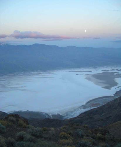
Perhaps the toughest adventure hikes in Death Valley are those that drop down from the heights of the Black Mountains to the valley near Badwater. One of those is this 6000ft descent from Dante's View through Hades Canyon. The asphalt road to the popular scenic viewpoint known as Dante's View ascends the eastern slopes of the Black Mountains and provides a quite dramatic vista overlooking Badwater only 2.5mi away as the crow flies. On a sunny day, the view is otherworldly with the glistening salt in the valley bottom contrasting with the red and gray crags and cliffs of the slopes below you. From Dante's View it seems almost impossible to make that descent because cutting longitudinally across the direct route are the great chasms of Hades Canyon and, a little further away, Bad Canyon. But by hiking north along the ridge on which you stand, you can find a way to descend into Bad Canyon and then follow a remarkable earthquake fault line to transition into the head of Hades Canyon. This hike then follows Hades Canyon down to the valley floor. However, that canyon bottom route is interrupted by many dramatic dryfalls, about 18 of which require rappelling. It is an adventure that is only for the very fit and very experienced canyoneer and one with experience fashioning deadman anchors. Finding or making safe anchors is very challenging in this canyon and you should take a variety of technical gear such as hexes, nuts and pitons as well as a large quantity of webbing.
Most groups will take 12hrs or more to descend Hades Canyon though the presence of fixed anchors may somewhat speed the hike. Nevertheless it is a very long hike and those wishing to complete it in one day should make a very early start. It is possible to hike the use-trail along the ridge before sunrise and that should be part of the plan. It would also help to plan the hike for the spring when the daylight is longer. Whatever the plan, anyone attempting this descent needs to be prepared to rappel in the dark or to face an overnight stop. Note also that there is no water anywhere along the route.
Trailhead
The Hades Canyon descent requires a long car shuttle. Perhaps the best base for this adventure is one of the campgrounds at the Park center in Furnace Creek. From there, the evening before the hike, you should drive south to Badwater (17mi away along Highway 178) in two vehicles in order to park the recovery vehicle. From the parking lot at Badwater continue south around two large alluvial fans, the first deposited by Bad Canyon and the second by Hades Canyon. Leave the return vehicle on the south side of the Hades Canyon fan about 36o12.24'N 116o46.41'W at an elevation of -240ft.
Then, before dawn on the day of your hike, you should drive southeast on Highway 190, climbing gradually along the Furnace Creek Wash between the Amargosa and Funeral Mountains. Ten miles from Furnace Creek, turn right onto Dante's View road and follow this for 13mi to the vista point. There are restrooms just before you reach the viewpoint and plenty of parking at the top. The Dante's View trailhead coordinates are 36o13.25'N 116o43.61'W and its elevation is 5475ft.
Hike
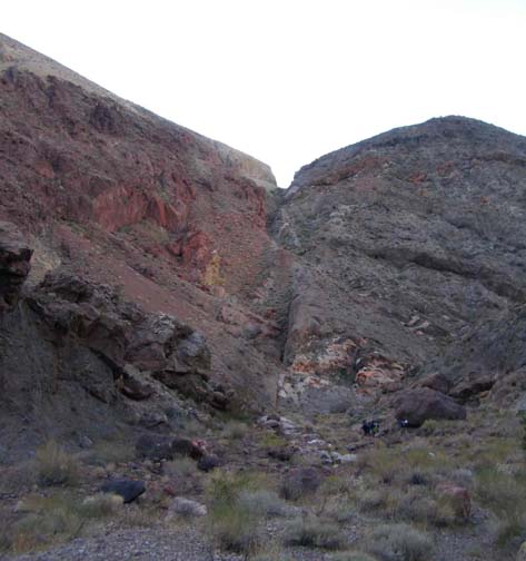
The first part of the Hades Canyon hike follows the same route from Dante's View down into Bad Canyon. You should start from Dante's View before sunrise to take maximum advantage of the daylight during fall or spring. Begin by hiking due north along the trail from the parking area (36o13.25'N 116o43.61'W and elevation 5475ft) to Dante's Peak (elevation 5704ft) just 0.4mi away and 230ft higher. Pause at the Peak to drink in the fantastic view. Then continue along the easy use-trail on the ridgetop, passing another small highpoint before descending toward a saddle at 5210ft, some 1.3mi and 37min from the parking lot. At about 5230ft just before you get to the lowpoint of the saddle you should be able to discern a low ridge that leads down to the west to a flat gravel wash about 500ft below you. There is a small rocky outcropping on this ridge about a third of the way down. Follow the ridge all the way down to the broad wash (elevation 4720ft). You should reach the wash about 50min after starting out. Then follow the wash for about 500yds until you reach a pour-off. Climb onto the low shoulder to the left of the wash and turn right to hike down in a northerly direction into the next gully. Once down at the head of this gully, hike up onto the ridge beyond the head. On the top of this ridge you should discern a steep but negotiable slope down into the wash of Bad Canyon itself. It is about a 200ft drop into Bad Canyon and you should reach the wash (elevation 3960ft) about 1hr 25min from the start having travelled about 2.5mi. The next 0.7mi is a straight and easy walk down Bad Canyon wash. Look ahead and you will see that the canyon makes an abrupt right turn. Straight ahead at this turn there is a clearly visible earthquake fault where the movement of the earth created a notable offset. This is the Hades fault that follows the line of Bad Canyon down to the sharp right turn and then proceeds over the ridge into Hades Canyon which it then follows down to the valley.
 | 
| |
|---|---|---|
| Badwater from Dante's View | Hades Fault and Saddle from Bad Canyon |
At the right turn (36o13.99'N 116o44.08'W, elevation 3480ft, 3.2mi and just under 2hrs from the start) start the hike up to Hades Saddle following a slight animal trail just to the left side. At the saddle (36o13.89'N 116o44.17'W and elevation 3710ft) you will get a spectacular view down into the rugged Hades Canyon; if it looks like a tough descent from here it gets alot tougher.
Starting down the going is initially loose with some downclimbs before you come to the first rappel at 3510ft just 200ft below the saddle. This is an easy 60ft drop in a slot from a solid chockstone anchor. More downclimbing follows and you soon arrive at a downclimb/rappel of about 20ft where the best climber might provide a belay and then free downclimb last. There are a number of similar drops in this canyon and this efficient method of descent will save time. Two more of these drops follow at 3290ft elevation (a 10ft drop) and at 2820ft elevation (a 12ft drop). Despite numerous smaller climbs this stretch is the easy part of Hades Canyon.
About 4hrs from the start at 2720ft, a large canyon enters on the left and it is worth a brief side trip about 100yds up this tributary to see the polished recess where two dry streams fall vertically about 200ft into a cathedral-like grotto. Downstream of this confluence the going continues fairly easy until about 2380ft where the slope increases and the rappels come thick and fast. About 4hrs 45min from the start at 2380ft there is a 40ft rappel down a chute from a boulder anchor and this is shortly followed by a double drop consisting of a 20ft rappel from a streambed boulder anchor down to a large platform where a long piece of webbing around a streambed outcropping anchors a 50ft rappel.
 | 
| |
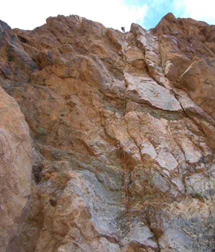
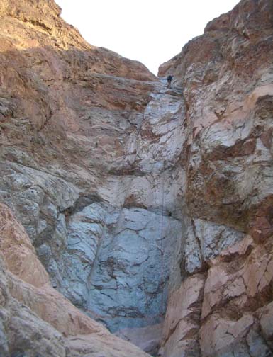
|---|---|---|
| 180ft rappel | 190ft rappel |
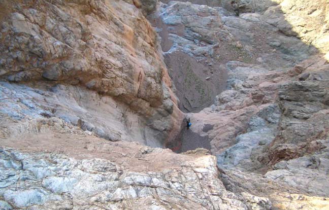
But these are just hors d'oeuvres for around 1800ft Hades Canyon really gets serious and between here and the canyon exit lie some serious canyoneering challenges. There are two sections, the first between about 1800ft and 1400ft and the second between about 1000ft and 700ft (both can be discerned on the topo map), where the drops are continuous and anchor fabrication is most challenging. These challenges begin at 36o13.05'N 116o45.09'W and an elevation of 1840ft about 4.7mi and 6hrs from the start, where you arrive at the top of a 25ft drop down to a large recessed shelf. This rappel is readily accomplished using a streambed boulder anchor. But what lies at the other end of the recessed shelf is enough to take your breath away for there is an awesome vertical chasm whose depth is difficult to discern without peering straight over the lip. It transpires the drop is about 180ft but it seems more. Moreover there were no natural anchors on the recessed shelf and we had to push boulders down from above the 25ft rappel in order to construct an adequate deadman anchor for the 180ft rappel. Just a short distance downstream you come to the next challenge a four-step drop where care must be taken with the sequencing. The difficulties can not be seen from the top where the entrance slot jogs left and then back right obscuring the view downstream. Moreover, there is no natural anchor for the first rappel. We installed two large hexes in a crack in the right wall at the top, rappelled down about 60ft around the corner to a large platform (devoid of natural anchors) and then continued the rappel down another 40ft step to a much smaller recessed platform. Because of the corners at the top the rope pull could be very tricky here so the last person down should manipulate any topside knots around the corner as he or she descends. The third in this sequence of four steps is a small 12ft drop that can be downclimbed (though the downclimb is not easy so the best climber should belay and go last). This downclimb places you on a 150sqft recessed platform with no natural anchors or good cracks. We installed a bolt in the right wall and backed it up with body belays for the final 60ft rappel in this series. It places you in a flat wash that leads to an easy but short section of canyon with a gravel bed.
|
|---|
| In the second dense series |
At 36o12.86'N 116o45.55'W and an elevation of 1140ft, 5.2mi and about 9hrs from the start you will arrive at the top of the second dramatic series of rappels. Like the first, it begins with a right turn leading to an awesome 190ft rappel for which we constructed a streambed deadman anchor. This takes you down to a large shelf that leads directly to a 60ft rappel for which we had to construct another streambed deadman anchor. And this in turn leads to an awkward third rappel for which we installed hexes in a slot on the right side of the lip. This rappel proceeds down a sloping lip and then drops to a recessed platform where it turns sharp right so the rope pull is awkward. At this point you have descended to 710ft but the continuous drops have not finished. The recesses platform ends in a slotted lip where we buried a deadman anchor in the bottom of the main slot and then rappeled down a two-step drop, the first step taking us down to another platform (with a right turn) and the second step completing this 130ft rappel. Again the rope pull could be tricky because of the turn.
After a short narrow section of canyon, you arrive at the top of the last big rappel at an elevation of 590ft and 11hrs 15min from the start. This is a three-step 150ft rappel from a very small platform with no natural anchors. We installed a good piton in the right wall (about shoulder high) and backed it up with body belays. This rappel is soon followed by a small 12ft downclimb and then by a real surprise. Here at an elevation of 460ft nearing the end of the canyon you will come upon a large aluminium aircraft fuel tank. At least that is what we guessed it was for upon the side was stamped ``Refuel through this filter cap only''. Just beyond the fuel tank you will arrive at the last rappel that proceeds down beside an awkward narrow sloping slot on the right from a streambed boulder/deadman anchor. Though less in terms of vertical drop it takes about 50ft of rope for this rappel.
Just a short hike down a broadening gravel wash and you will come
to the exit of Hades Canyon at
36o12.65'N 116o45.92'W and an elevation
of 120ft, roughly 5.7mi and 12hrs 20min from the start.
Follow the streambed as it veers left exiting the canyon and begins the
descent of the large alluvial fan. If you head roughly southwest you should have
no difficulty locating your return vehicle at
36o12.24'N 116o46.41'W
and an elevation of -240ft. The complete hike, about 6.4mi
long, took us 12hrs 40min though others may be able to utilize at
least some of our anchors and thus do it faster. Be aware, however, that
flashfloods could wash out or bury many of our streambed anchors.
Last updated 11/20/03.
Christopher E. Brennen