ADVENTURE HIKES AND CANYONEERING
IN THE SOUTHWEST
© Christopher Earls Brennen

|
|---|

|
Hike A6. Flatiron Plus
- Hiking time: 5 hours
- Estimated hiking distance: 5 miles
- Elevation gain: 2930 feet
- USGS Topo Maps: Goldfield
- Difficulties: Some small free climbs, some route finding
- Special equipment: None
-
ACA Rating: 1A III

Characteristics
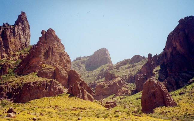
As you head east from Phoenix across the desert flats of the valley of the sun, a great massif looms up ahead of you, like an ocean liner in a sandy sea. These are the Superstition Mountains, rugged peaks of water- and wind-sculpted rock, a land of steep cliffs and deep canyons. The face that the Superstitions present as you drive toward them is one of huge, seemingly insurmountable cliffs topped by a labyrinth of pinnacles. One particular summit juts out from the massif like the prow of a great ocean liner. This is Flatiron, one of the few summits to have its own name. It looks impossible to reach the flat top of that landmark. But this hike takes you up that imposing face of the Superstitions to the top of Flatiron and, if you wish to the higher summit just behind it. From that summit there is a magnificent view of the desert to the west and of the Superstitions to the east.
This hike is best for March or April when the wildflowers are in bloom and the heat is moderate. It is also good during the rest of the fall, winter or spring. Avoid the heat of summer. Also avoid climbing during or shortly after rain when the rock can be slick. I also recommend starting early in the morning (6am to 7am is good) so that you can accomplish most of the climb while still in the shadow of the mountains.
Trailhead
From Phoenix follow Highway 60 east for about 40mi to Idaho Road in Apache Junction. Go north on SR88 (Idaho Road) for about 3mi where you turn right following the Apache Trail. About 5mi past the turn look for the signs for the Lost Dutchman State Park. Turn right into the park, pay the $5 entrance fee and follow the signs for the Siphon Draw trailhead (33o27.22'N 111o28.81'W). Park at the trailhead.
Hike
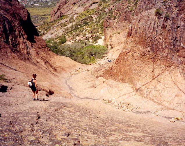
From the trailhead (33o27.22'N 111o28.81'W and elevation 2090ft), follow the Siphon Draw Trail as it rises first gently and, later, more steeply on a relatively straight course southeast toward a wide gap in the frontal cliffs of the Superstition massif. The well-worn trail contours into the Siphon Draw valley and climbs into the Superstitions along the left side of the canyon. Now unmaintained, the rough trail eventually reaches the stream bed at the bottom of a bare rock gully or basin (33o26.48'N 111o27.58'W) at an elevation of 3100ft, 1.6mi and 50min from the start.
|
|---|
| Siphon Draw with Flatiron overhead |
This is where the casual hiker turns around. Just a few yards into this rock-walled basin, there is a vertical, 40ft dryfall on the left. To bypass the dryfall, climb the sloping rock to the right and continue to follow the use-trail straight up the steep slope to a crest overlooking the streambed above the dryfall. You should reach this 3360ft crest about 1hr 10min from the start. Take time here to survey the scene on the other side of the crest. Above you to the left is are the steep, unbroken cliffs of Flatiron, whose prow-shape is unmistakable. Two steep gullies ascend to the saddle to the left of Flatiron, the right-hand gully being the ascent route. A well-used trail contours across from the crest into that gully.
It is a long, steep climb up the bed of the gully to the saddle high overhead. Follow the white dots up the bed and avoid the temptation to climb out of the gully on any of the small trails that seem to climb to the right. Though steep and long, this part of the hike is straightforward. However, near the top, there are several places where a little careful climbing is needed, particularly just before the top where there is an easy 12ft vertical step. The top of the gully (33o26.31'N 111o27.05'W and elevation 4540ft) is just a short distance below a broad saddle and you should reach this point 2hr 10min from the start.
From the top of the gully, an easy level trail turns sharp right and contours across to the top of Flatiron. You should reach the apex of the ``prow'' at 33o26.27'N 111o27.26'W and elevation 4640ft just 5min later. It is a 2.5mi hike from the trailhead to this point and well worth the effort for the view to the west is spectacular. Peering over the edge you can see the trail winding up Siphon Draw far below you.
 | 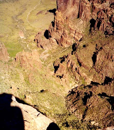
| |
|---|---|---|
| The Basin | View of Siphon Draw from Flatiron |
Those who have had enough at this point should return the way they came. The return hike to the trailhead should take about 2hrs. However, an even more spectacular view awaits those who are willing to do a little more climbing. When you look back in an easterly direction from the prow of Flatiron, you will see two nearby pinnacled summits above your present elevation. The lefthand summit is the higher, indeed at 5024ft it is the highest peak in the vicinity. We are bound for that summit.
After returning to the top of the gully, hike the short way up to the broad saddle (33o26.31'N 111o27.02'W and elevation 4700ft) between the two clusters of pinnacles. At the saddle, note the opening in the higher globular rock mass to your left. You should be able to find the use-trail that climbs into this opening, negotiating several small climbs before reaching a saddle in the middle of the rock mass. From the saddle an opening in the rock gives you a preview of the marvellous view you will enjoy at the summit. From the saddle, proceed up to the right following a use-trail just to the right of a ridge. The route climbs rocks in places but, by following the ducks you can reach the summit with only modest difficulty. It should not take more than 30min to reach the 5024ft summit (33o26.36'N 111o26.92'W) from the top of the gully.
The view from the summit is expansive and spectacular. Five miles due east you can see the twin towers of Weaver's Needle and further south but nearer, the highest peak in the range, the 5057ft Superstition Mountain. And, if you come in the spring, you will be surrounded by beautiful desert flowers and flowering cacti. It is a place to drink in the beauty of the desert and bless those who have preserved this wilderness.
When you must leave, retrace your steps down to the broad saddle and from
there down the long steep gully. It should take just over 2hr to
descend from the summit to the trailhead.
Christopher E. Brennen