ADVENTURE HIKES AND CANYONEERING
IN THE SOUTHWEST
© Christopher Earls Brennen

|
|---|

|
Hike G2. Coffin Canyon, Death Valley
- Hiking time: 6.5 hours
- Estimated hiking distance: 7.4 miles
- Elevation gain: None
- Topo and other maps: Dantes View, Badwater and National Geographic Death Valley National Park map
- Difficulties: About seven rappels, one of 190ft
- Special equipment: Two 200ft ropes, 200ft retrieval line, 100ft webbing, 7 rappel rings, rappelling equipment, helmets and leather gloves
-
ACA Rating: 3A III

Characteristics
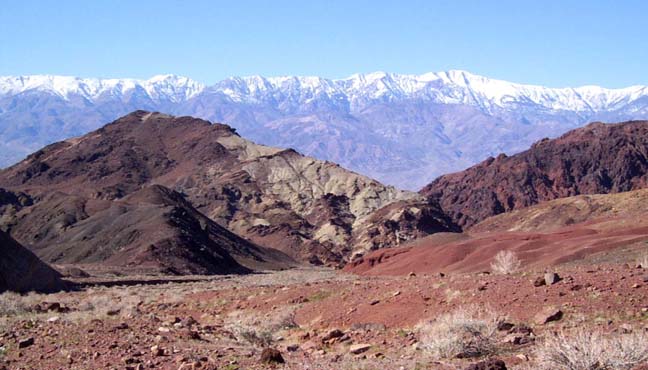
Death Valley National Park contains some of the most rugged and fantastic terrain in the world and provides some marvellous canyoneering experiences. Though the heat in the summer is intolerable, the Park has the advantage that the mild winter weather allows outdoor activity when much of the rest of the southwest is too cold and wintery. While it does occasionally rain in the valleys and snow often covers the high peaks in the winter, at lower elevations the temperatures are perfect for exploring the many narrow, multicolored canyons that line both sides of the flat valley bottom. This collection of adventures contains several in Death Valley National Park. Though the hike to the summit of Telescope Peak is a summer outing, the other, canyoneering adventures included in this collection are best suited for the late fall, winter and early spring. If you plan to do much hiking in the Park, I strongly recommend you buy Michel Digonnet's excellent book "Hiking Death Valley".
Coffin Canyon is one of the series of technical canyoneering adventures in the steep terrain of the Black Mountains south of Badwater on the east side of the valley. It is less demanding than Bad, Hades, or Styx Canyons, but has a number of dry rappels including one spectacular 190ft vertical drop in a deep cliff-ringed chasm. The main drawback is a long car shuttle including travel over some rough and poorly signposted dirt roads.
Trailhead
Coffin Canyon has the same upper trailhead as Styx Canyon and therefore involves the same long, rough car shuttle requiring at least two high clearance vehicles. This is best initiated the evening before your descent beginning at a point on Highway 178 roughly 24.7mi south of Furnace Creek, 8.0mi south of Badwater, and 21.3mi north of the Ashford Junction with the Henry Wade road. This point lies between the two large alluvial fans of Coffin Canyon and, to the south, Copper Canyon. Park the return vehicle here (36o8.84'N 116o46.01'W) at some convenient spot along the highway.
Then drive 24.7mi north on Highway 178 to Furnace Creek; at the junction there turn right onto Highway 190 and drive 9.2mi south where you should turn right following the asphalt road to Dante's View. Just 7.5mi up this road from the Highway 190 junction, look for the dirt road that goes left labelled either Greenwater Valley Road (GVR) or Furnace Creek Wash. Follow the well-graded GVR for 2.8mi looking carefully for a much rougher road that branches off to the southwest from a point labelled 3480.9 on the topo map (36o14.13'N 116o38.24'W). Note that it is permissable to camp along GVR as long as you are more than 2mi from the asphalt at either end and this may provide an alternative to camping overnight at Furnace Creek.
The rough dirt road portion of the approach to the trailhead begins at point 3480.9 (36o14.13'N 116o38.23'W) and proceeds southwest for 3.5mi to the site of the encampment of Furnace (36o11.48'N 116o39.89'W, labelled 4770T on the topo map) where there may be several side roads joining. Continue on southwest and straight on through Furnace for about 0.3mi to a major fork at 36o11.32'N 116o40.09'W where you fork right down into a gully. Follow the dirt road as it winds west up into the hills with many ups and downs. Finally the road turns north-northeast and descends again before turning up another gully at 36o12.61'N 116o40.78'W. After another 0.3mi you reaches the top of a broad ridge where the road switchbacks north again. Park here at this second switchback where it is easy to pull off the road (36o12.43'N 116o40.91'W and elevation 4470ft). Note that the topo map shows a much quicker but rougher shortcut from the point 4140T (36o12.47'N 116o39.20'W to the parking place but this has been closed by the Park Service.
Hike
The terrain near the starting point (elevation 4470ft) is gently sloping and easily travelled. Start by hiking west and a little south, aiming to descend into the obvious shallow valley off to the northeast of the starting point. This is a minor fork of Coffin Canyon. After about 20min and 1mi you should drop into the wash at an elevation of around 4280ft. A short distance beyond this the short narrows of this minor fork begin with some small downclimbs. Then about 1hr from the start at 3620ft you will arrive at a 15ft downclimb where some may need a belay. The next obstacle is a 60ft vertical rappel where this fork meets the main branch of Coffin Canyon (36o11.77'N 116o42.39'W). For this rappel you can use a webbing wrap on the large boulder to the right of the lip. Note however that there is an easy downclimb in a gully just over to the right. You should reach the main wash of Coffin Canyon at an elevation of 3400ft about 1.7mi and 90min from the start.
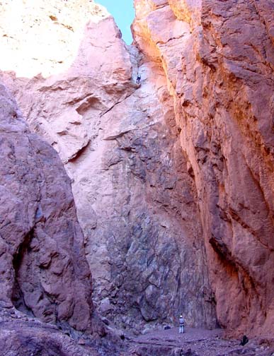
 | 
| |
|---|---|---|
| Entrance to lower gorge | The 190ft rappel (Photo by Mark Duttweiler) |
The gravel wash at this point is broad, flat and fast and you will make quick time over the next several miles. At 2920ft, 2hrs from the start you will pass the first of several low saddles that allow passage between Coffin Canyon and Copper Canyon, the next canyon to the south. Note however that access to Copper Canyon is restricted to protect the ancient mammal tracks that are being studied and preserved. Apparently ranger-led trips into Copper are sometimes organized and some have transitioned into Coffin Canyon via the saddle at an elevation of about 2100ft. You should pass this second saddle about 4.0mi and 2.5hrs from the start. There is yet another small saddle passage at about 1250ft just before you enter the lower gorge.
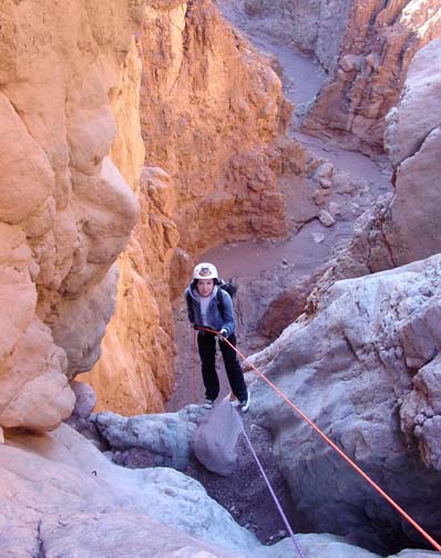
 | 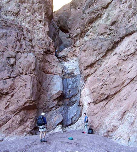
| |
|---|---|---|
| The 190ft rappel (Photo by Mark Duttweiler) | The 25ft penultimate rappel |
The colorful entrance to the lower gorge (36o9.24'N 116o44.84'W) is visible for sometime before the wash begins to narrow and you enter the narrows. The cliffs on the left side are grey-green and vividly contrast with the stark red cliffs on the right. You will begin to enter the gorge at 1150ft about 5.6mi and a little over 3hrs from the start. As you do so notice a neat but short slot canyon in the right wall. The sculpted and pockmarked walls of the canyon begin to rise precipitously on both sides and the floor begins to drop more rapidly. After several downclimbs at an elevation of 800ft and 3.5hrs from the start you will arrive at a 25ft drop that can be rappelled if you wish but can also be walked around on the right. Just 50yds further on there is another small 20ft drop that can be downclimbed or rappelled using an anchor rock in midcanyon. Another short hike brings you at 650ft elevation to the awesome dropoff in this canyon, a 190ft vertical drop into a cliff-ringed chasm that makes for a heart-stopping view from above. You should reach this challenge about 4hrs from the start. The anchor for this rappel consists of a set of two bolts in the solid bedrock of the lip. Some portions of the descent are free rappel so some may prefer a fireman's belay from the first descender.
You are now in a deep narrow canyon and the steep drops come with little pause. Just a short distance downstream of the big rappel there is a 30ft rappel using a webbing anchor around a buried rock - an anchor that needs replacement. Beyond this there is a rapid series of short downclimbs in a narrow slot before you arrive at an elevation of 540ft at the end of the slot; here the canyon opens abruptly and at this opening there is a 25ft vertical rappel that is anchored by two bolts (one old, one new) in the vertical face below the lip but above a comfortable shelf. It may seem as though this is the end of the canyon, but just a short distance downstream there is a 25ft dryfall that could by rappelled using one of the boulders at the lip but can also be bypassed via a ledge on the left that leads to a steep but downclimbable gully. Round the corner from this downclimb you will arrive at the top of the last rappel, an 80ft vertical drop into a slot. This is anchored by a webbing wrap around a large boulder. During this last rappel it is amusing to know that you are passing through sea level.
From the bottom of the last rappel it is only 50yds to the abrupt
and dramatic canyon exit
(36o9.16'N 116o45.98'W). You should reach the
exit (elevation -20ft)
a little over 6hrs from the start having travelled about 7mi.
Turning left it is an easy stroll down the large alluvial fan of
Coffin Canyon to Highway 178 and the return vehicle
(36o8.84'N 116o46.01'W and an elevation of
-240ft). The total hike
length and duration should be about 7.4mi and 6.5hrs.
Last updated 1/22/05.
Christopher E. Brennen