ADVENTURE HIKES AND CANYONEERING
IN THE SOUTHWEST
© Christopher Earls Brennen

|
|---|

|
Hike L4. Cardwell Point, San Miguel Island
- Hiking time: 2.5 hours in a 4 day expedition
- Estimated hiking distance: 6 miles
- Elevation gain: 630 feet total
- USGS Topo Map: San Miguel Island East
- Difficulties: Access: hike must be accompanied by a ranger
- Special equipment: Binoculars
Characteristics
San Miguel is the westernmost of the Channel Islands and part of the Channel Islands National Park in the Santa Barbara channel. It is a remote and wild place where you can only hike if guided by the Park Ranger. Three hikes on San Miguel are listed in this collection and, though guided, qualify as adventure hikes because of the unique destinations and the adventure involved in getting to the island and camping there.
The island consists of a relative flat plateau ringed by coastal bluffs and cliffs. Until about 40 years ago, the island had been almost denuded of vegetation by the sheep that were raised on the island. The result was that much of the island was covered in driven sand blown in by the prevailing northwest winds. In the intervening 40 years much of the island has recovered some vegetation though there are still some sand-blown areas. There are, however, almost no trees and the island is largely covered by grass and low bushes. Unlike the neighbouring islands to the east, San Miguel is not sheltered from the northwest winds by Point Conception and the mainland. Consequently the weather is rather different, being either foggy or windy.
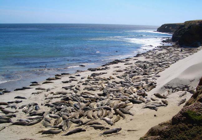
The principal attractions on San Miguel are the amazing spectacles of tens of thousands of seals resting, birthing and breeding on the beaches of the island. This hike to Cardwell Point, the extreme eastern end of the island, allows one to observe a beach filled with elephant seals from an overhead cliff edge.
Trailhead
A concessionaire, Islandpackers, runs ferries to all four of the islands of the Santa Barbara channel, which, reading from east to west, are Anacapa, Santa Cruz, Santa Rosa and San Miguel. Their headquarters and principal port of embarkation are a jetty next to the visitors center at Ventura Harbor. They operate roughly 10 visits a year to San Miguel with, typically, an outbound trip on Friday and the return journey on Monday. The ferry usually makes stops at Santa Cruz and Santa Rosa on the way to San Miguel and it therefore takes about 5hrs to get to San Miguel. There are no accommodations on the island other than the campground so one must come prepared for rough camping for two or three nights. Because of the wind and fog, camping is rather more challenging than usual in Southern California. The lone campground has sites that are equipped with windbreaks (as well as food-boxes and tables). Moreover, there is no water available so that campers must bring their own from the mainland. Camping reservations must be made with the National Park before booking passage to the island.
Unlike the other islands, there is no jetty at San Miguel and the landing is an adventure in itself. The ferry anchors in the sheltered bay called Cuyler Harbor and then, aboard a Zodiac, passengers are ferried, six at a time, through the surf to the pristine beach that lines the bay (34o2.83'N 120o21.06'W). Packs and other camping gear (including water) are similarly landed. Don't be surprised if a group of elephant seals are sunning themselves on the beach beside where you land!
From the beach, a steep trail ascends the coastal bluffs by climbing up the side of Nidever Canyon just inland of the landing point. Climbing out of the canyon onto the island plateau the trail heads east to a small saddle where the campground is located, at 34o2.45'N 120o20.95'W), an elevation of 490ft and 0.7mi from the beach.
Hike
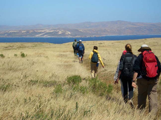
This ranger-led hike begins at the campground (34o2.45'N 120o20.95'W and elevation 490ft) and proceeds up to the airstrip beside the Ranger Station (34o2.36'N 120o21.01'W). Hiking east along the airstrip, the trail forks off to the southeast near the end of the runway and, after cresting a very slight summit at 570ft), begins a long gradual descent toward the eastern end of the island. The landscape here is almost featureless grassland with just a few patches of low bushes. It is so flat that it is known locally as the ``gangplank''. Ahead, at the bottom of the long slope, you can see the stretch of water between San Miguel and Santa Rosa (known as San Miguel Passage) and, of course, the island of Santa Rosa itself. For a time the trail follows the north bank of a shallow draw known as Willow Valley (the willows are much further downstream) before crossing (34o1.58'N 120o19.61'W) to the south and veering off in that direction. Eventually you come to steeper descent near the coast and follow the remains of an old road with a bleached bed. Heading down toward the sea you veer south in order to reach the western side of a slight promontory which can be seen in the distance. We note here that the large sandspit shown on the topo map at the eastern end of the island is no longer extant and the coast now follows the first contour much more closely. The trail takes you to a low bluff on the eastern end of the cove that is just to the west of the slight promontory mentioned above. You should reach this destination (34o1.21'N 120o18.63'W) about 1hr 15min and 3mi from the campground.
 | 
| |
|---|---|---|
| Hiking toward Cardwell Point; Santa Rosa in background | Cardwell Point beach covered with elephant seals |
From this low bluff, you will get a close-up view of a beach which is literally packed with elephant seals. In order not to alarm them you lie along the edge of the cliff looking down on this mass of elephant seal. It is an amazing sight and one could spend hours watching their slow-moving interactions.
The hike back to the campground
(34o2.45'N 120o20.95'W)
is a long uphill drudge usually into a strong
headwind.
Last updated 6/1/05.
Christopher E. Brennen