ADVENTURE HIKES AND CANYONEERING
IN THE SOUTHWEST
© Christopher Earls Brennen
|
|---|

|
Hike M1. Boquillas Canyon, Big Bend National Park, TX
- Hiking time: 2 hours
- Estimated hiking distance: 1.7 miles
- Elevation gain: 100 feet
- USGS Topo Map: Boquillas Canyon
- Difficulties: Heat
- Special equipment: Hat, wading shoes, much drinking water
Characteristics
Boquillas Canyon in the Rio Grande river forms a section of the international border between Mexico and the United States. It is the easternmost of the three main narrows sections along the Rio Grande within Big Bend National Park, Texas; it is about 20 miles long, starting just east of Rio Grande Village at a point where the river is designated wild and scenic. The canyon can be explored on foot but for most of the year, a boat is the only adventure option for the water is deep and fast flowing.
The canyon is in the far southeast corner of Big Bend National Park along Texas road 118. past the Rio Grande campsite and a turn-off leading to an unofficial international border crossing to the village of Boquillas del Carmen, Mexico. The approach to the canyon is quite dramatic - the high, layered cliffs around the Rio Grande river are topped by huge, angular mountains on the Mexican side of the river. At the end of the road is a spacious parking area. A well-used 0.7 mi path leads up and over a stony ridge, through a sandy area with thick bamboo and then out onto a pebble beach at the US side of the Rio Grande river. Gaunt cliffs tower above, and close in downstream. A distinctive feature on the Texas side is a large sand drift half way up the cliffs, formed by the prevailing winds blowing sand from the desert into the mouth of the canyon
The canyon downstream is explorable if the water at this point is 2ft deep or less. However repeated river crossings are required to proceed downstream and there are large overgrown sandbanks on both sides of the river. By negotiating these you may proceed downstream for about 2 mi. There are well-defined tracks through the undergrowth beside the river, made by the mules and semi-wild horses which inhabit this area.
Trailhead
From Interstate 20 just west of Odessa, Texas, exit the interstate at 31.59256oN -102.90401oW (and an elevation of 2611ft) and proceed south on Texas 18 to Fort Stockton and thence to Marathon, Texas, a distace of 163mi from the Interstate.
Marathon (30.20399oN -103.235041o and an elevation of 4077ft) is the local railway depot and essentially the last fuel/food stop before the Big Bend National Park. There is also a nice little hotel, the Gage Hotel, a convenient overnight stop. Proceeding south from Marathon on Route 385, it is a further 68mi to Panther Junction in Big Bend National Park (29.32940oN -103.20591o and an elevation of 3730ft). This is the location of the Big Bend Visitor Center and the source for information on trails, campgrounds, etc. From Panther Junction drive 19mi southeast on Rio Grande Village Road to the junction at 29.19520oN -102.96o (elevation 1868ft) of the Rio Grande Village Road and the Boquillas Canyon Road. Turn left onto the latter and drive 3.5mi to the Boquillas Canyon trailhead parking area at 29.201031oN -102.919813o (elevation 1842ft).
Hike
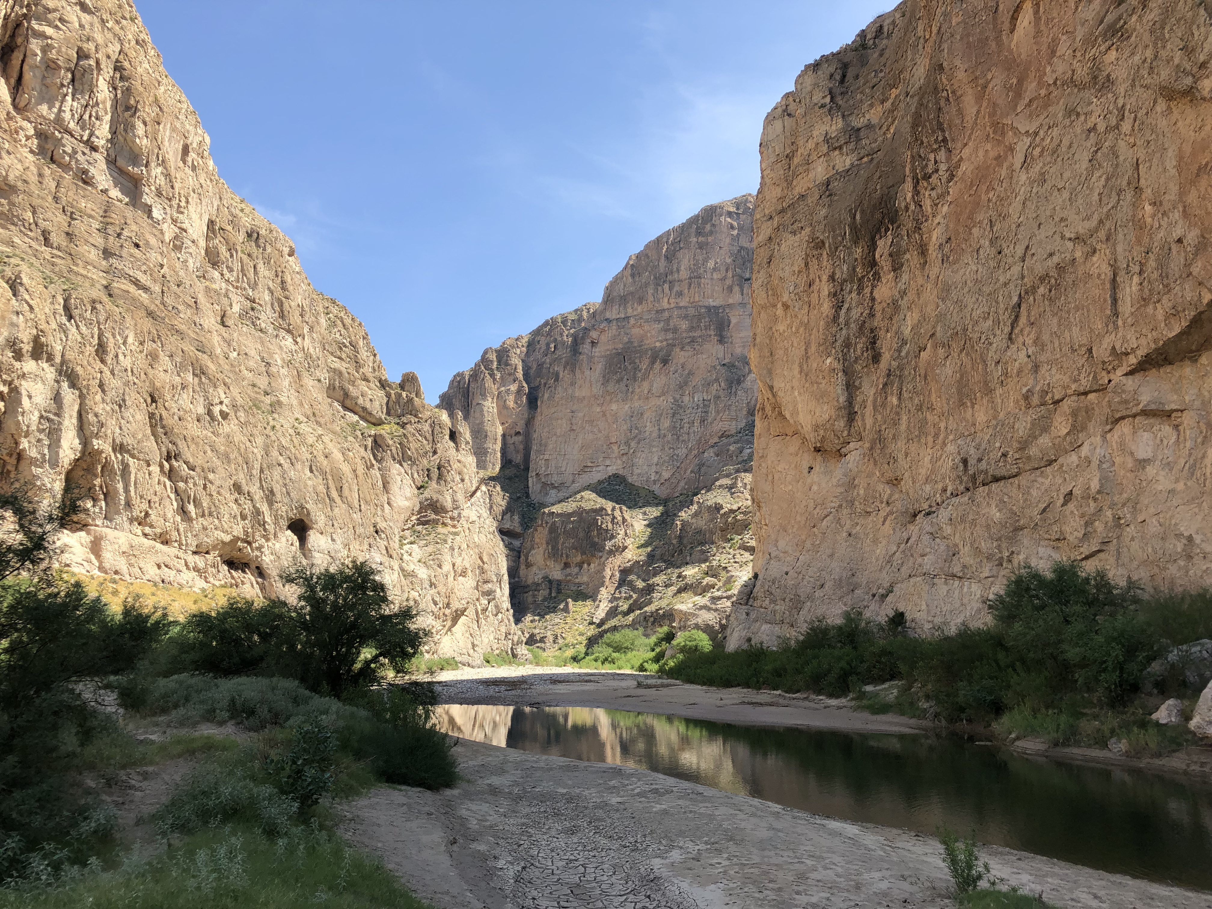
From the parking area (29.201031oN -102.919813o and an elevation of 1842ft), the Boquillas Canyon Trail climbs a series of steps about 100ft up over a stony ridge before descending to the shore of the Rio Grande river after 0.7mi. The approach is quite dramatic - the high, layered cliffs around the river are topped by huge angular mountains on the Mexican side of the river, part of the Maderas Del Carmen Protected Area. Gaunt cliffs tower above, and close in downstream. A distinctive feature on the Texas side is a large sand drift half way up the cliffs, formed by the prevailing winds blowing sand from the desert into the mouth of the canyon. This beautiful canyon has drawn people to it for thousands of years. In the bedrock along the river look for mortar holes where nomadic tribes ground seeds. roots and mesquite beans. This method of food preparation created deep circular pits over generations of use.
|
|---|
| View from mouth of Boquillas Canyon. |
While both sides of the river were still part of Mexico, floodplain farming communities grew up along the river. As zinc, flourite and other minerals were discovered in the Sierra del Carmen, the river was a meeting place for exchange . An aerial tramway was constructed to carry the ore to the railroad in Marathon.
The official trail ends by the Rio Grande at 29.20390oN -102.91390o where a cliff blocks progress on the US side of the Rio Grande. At low water levels, the canyon may be explored further on foot but for most of the year, a raft is the only option for the water maybe deep and fast flowing.
The canyon downstream is explorable for at least another 2mi if the water at the end of the trail is less than 2ft deep. Progress requires repeated crossings between quite extensive, overgrown sandbanks on either side. There are well-defined tracks through the undergrowth beside the river made by the mules and semi-wild horses which inhabit this area. The whole canyon is about 20mi long but acces to the other end is very difficult.
If you wish to cross into Mexico legally, you should have your passport on hand and drive back from the parking area along the Boquillas Canyon road, past the turn off to the Boquillas Canyon Overlook and turn left at the junction with the Rio Grande Village Road. Follow that for a short distance to the Rio Grande Village and Campground. There you will need to check in at the US Boquillas Port of Entry before proceeding to the shore of the Rio Grande to be ferried across the river ($5 per person at last check). On the Mexican side it is a short walk to the village of Boquillas del Carmen where there are souvenir shops and restaurants. Make sure you know the times of opening of the US Port of Entry on the way back to avoid difficulties.
Last updated 6/9/01.
Christopher E. Brennen