ADVENTURE HIKES AND CANYONEERING
IN THE SOUTHWEST
© Christopher Earls Brennen

|
|---|

|
Hike K6. Agua Blanca Canyon Hike
- Hiking time: 6.5 hours
- Estimated hiking distance: 11 miles
- Elevation gain: 1920 feet
- USGS Topo Map: Cobblestone Mountain
- Difficulties: A short wade/swim through the Devil's Gateway
-
Special equipment: Drybag
Characteristics
This adventure hike takes you through a small corner of the rugged Sespe Wilderness. Its attractions include the curious geological depression known as the Pothole and the beautiful Agua Blanca canyon and river which, in one place passes through a narrow slot known as the Devil's Gateway. The rich bird life supported by Piru Creek and Lake Piru is an added bonus.
The Pothole was caused by a gigantic slide that descended across the canyon forming a large dam. Over the years, the area back of the dam has filled in with sand and silt until it has now formed a floor. This area sometimes floods for a very short period after very heavy rain. A grove of cottonwood trees covers part of the flat area. Where the trail enters the Pothole the entrance is partially covered by sand, silt and weeds and the remains of an old horse drawn hay rake.
This hike is best in the early spring when the weather is still cool enough to make the ridge climb comfortable. But it should not be undertaken too soon after rain for the Gateway may then become difficult to negotiate.
Trailhead
Drive north on Interstate 5 from Los Angeles through Santa Clarita and then west on highway 126 for 12mi to the town of Piru. Proceed into the center of the town and then follow the signs to the Lake Piru road. From the town it is 6.5mi north to the entrance station for the Lake Piru marina. Drive on 2.5mi to the new Pothole parking area. The well-signposted Pothole trail-head (34.51312oN 118.76092oW and a elevation of 1100ft) is just a short distance further along the tarmac road on the left.
Hike
The Pothole trail switchbacks for 1.9mi and climbs 1910ft to the ridgetop (34.51312oN 118.76092oW) at 3016ft. At this point you pass into the Sespe Wilderness and the views west are particularly spectacular on a clear day. Here you veer left, continuing along the ridge and briefly descending before resuming the climb. Soon, and somewhat unexpectedly, you arrive at the point (elevation 3190ft and about 2.4mi and 2hr 20min from the trailhead) where the clearly marked trail leaves the ridgetop and contours off to the right through thick brush. When I passed this way I was thankful that the trail was well cleared.
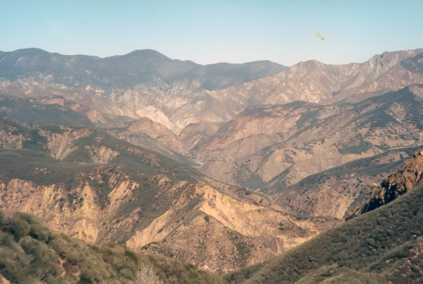
|
|---|
| View west from the summit |
The trail then descends through high brush, crossing a notable saddle and then switchbacking down toward the valley. Along this part of the trail there are a number of points at which you should pause to enjoy several interesting features below you. At one location you will get an excellent view of the Pothole, a mudflat surrounded by trees. And further down, you will also get fine views of the Devil's Potrero a large grassy flat adjacent to the Pothole and clearly of the same geological origin. You may also catch a glimpse of the spectacular rock cleft called the Devil's Gateway through which you will make your way a little later. Near the end of the descent the trail is less well maintained and somewhat brushy. But about 3hr 10min and 4.3mi from the trailhead you should reach the grassy bottom at Devil's Potrero (34.51312oN 118.76092oW, elevation 2280ft). If you wish you can detour here and proceed upstream to inspect the Pothole a few hundred yards away. The main trail proceeds downstream along the canyon bottom. At the lower end of the flat you will pass the remains of a cabin, around which are scattered various pieces of farm equipment left by someone who must have tried to farm the Potrero.
At the cabin, you need to exercise care to locate the trail which now decends steeply through a heavily wooded glade. Eventually, this side canyon joins the main canyon of the Agua Blanca river right at the entrance to the Devil's Gateway (34.54939oN 118.80268oW and an elevation of 1516ft and 5.2mi from the start). This narrow cut with vertical walls 100ft high, comes upon you quite suddenly as you emerge from the side canyon. I reached this point 4hr from the trailhead.
The Agua Blanca is a sparkling and attractive stream and this is a great spot for a rest and lunch before tackling the Gateway. Though a trail once led up and over a bluff to bypass the Devil's Gateway, it is much easier to wade/swim through the pool in the narrows (providing you brought a dry bag). It is a straightforward matter to wade through the pools of the Gateway as long as you don't come this way too soon after a winter storm. The pools are normally about thigh-deep. It is good idea to pick out a branch to serve as a walking stick while making this transit. The stick allows you to find the shallowest route through the pools. The vertically walled section is quite short. But when you think you are done with the wading there are two more pools just a short step downstream which also need wading.
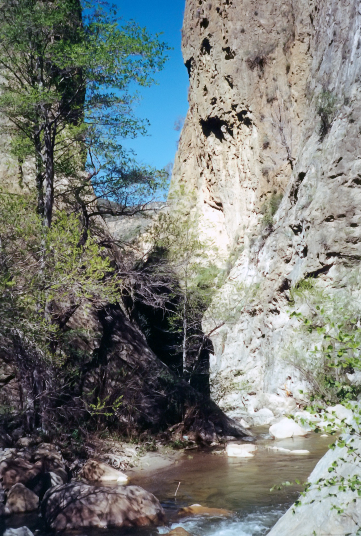
|
|---|
| The Devils Gateway from upstream |
The trail downstream crosses Piru Creek twice between the Agua Blanca and the Blue Point campground. It is very wise to proceed cautiously when making these crossings. If the water is higher than knee deep you should not proceed with the crossing but find a way down on the west side of the creek. Whatever the state of the river, use a stout stick to maintain your balance during the crossings.
You should reach the site of Blue Point camp 6hr 45min after
starting the hike having walked 9.2mi. From there follow the asphalt
road for another 1.5mi back to the trailhead
(34.51326oN 118.76081oW) and 11mi from the start).
Christopher E. Brennen