THE FAR SIDE OF THE SKY
© Christopher Earls Brennen
YOSEMITE'S HAUNTED CANYON
`` ... I will not leave my home but be with the spirits among
the rocks, the waterfalls, in the rivers and in the wind;
wheresoever you go I will be with you. You will not see me,
but you will fear the spirit of the old chief, and grow cold.''
From speech by Chief Tenaya of the Ahwahneechees.
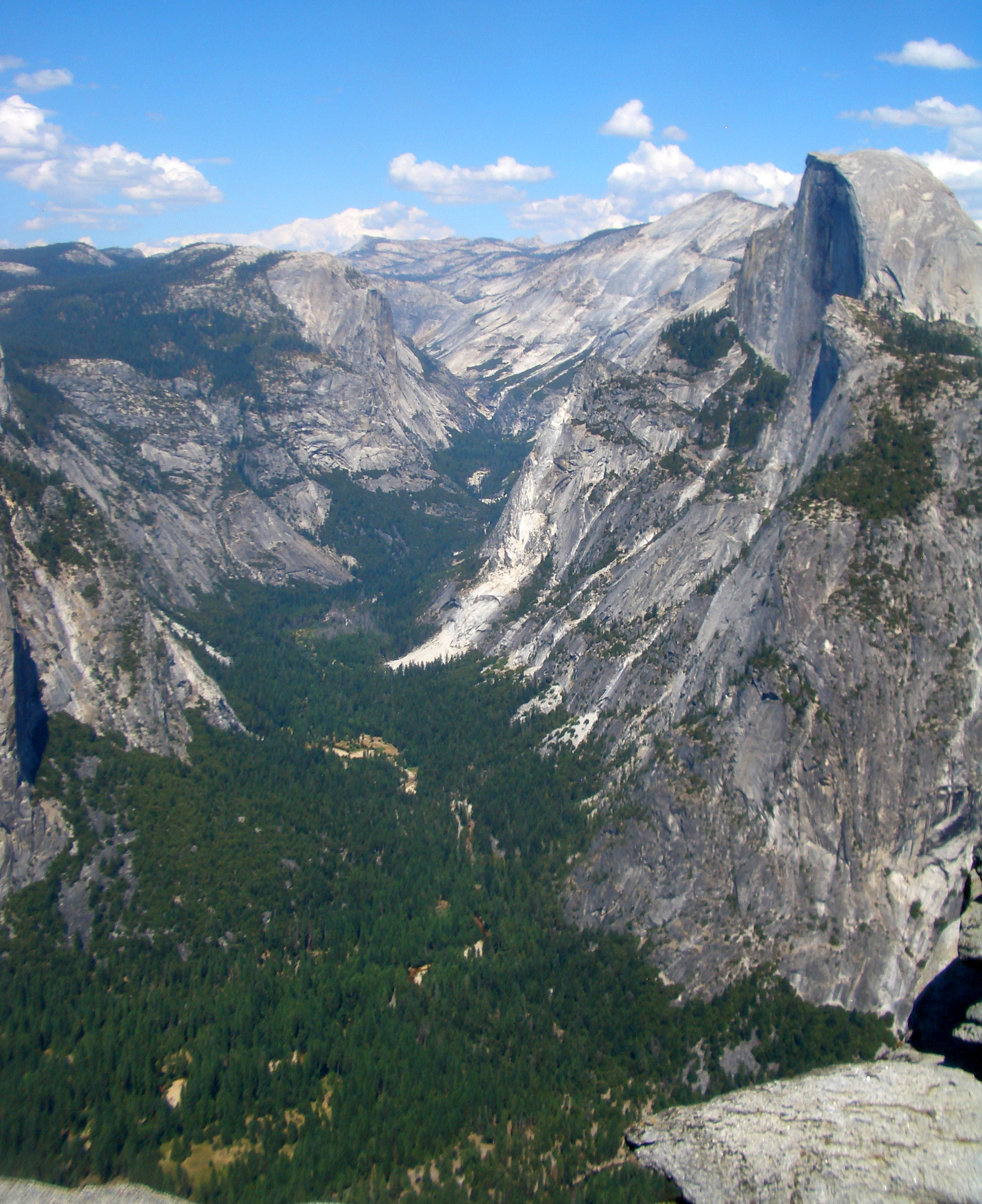
The great glacier that carved out the spectacular monuments of Yosemite National Park began up in the high country east of the valley near the beautiful swaths of Tuolumne Meadows. Nowadays the tourist can only see a part of the glory which that process created for the road stops where the flat valley floor ends near Mirror Lake in the shadow of Half Dome. A short distance beyond that point travel along the bottom of the gorge becomes very difficult due to the ruggedness of the terrain. So difficult, in fact, that the trails terminate just a mile or so upstream of Mirror Lake and there are signs warning that travel beyond that point is dangerous. But nature's glory does not stop there. Between the valley and Tenaya Lake some 10 miles upstream is a magnificent canyon with enormous rock faces and spectacular scenery.
Tenaya Lake, Creek and Canyon take their name from the shrewd old chief of a band of native Americans who called themselves the Ahwahneechees and were living in Yosemite Valley (which they called Ahwahnee) when the white men first arrived. Numbering about 200 the Ahwahneechees had already been ravaged by the white man's diseases that had preceded him. Sometimes the younger men would travel west toward the lowlands to poach from the white settlements and ranches there. But generally they lived peaceably on a diet of acorns, roots and game, surrounded by some of the most spectacular scenery in the world.
In the early 1850s, the white settlers decided to remove the Ahwahneechees to a reservation near Fresno and sent a battalion of men to effect this deportation. Needless to say the Ahwahneechees did not want to leave their valley. There followed a number of evasions, negotiations and escapes. Months passed and when a second battalion under a Captain John Boling entered the valley to resume the deportation effort, the confrontation turned violent. Several young Indians were captured and one was shot while trying to escape. This young man was one of Chief Tenaya's favorite sons. When the old chief was informed, he was enraged and during a confrontation with Captain Boling expressed that anger in laying a curse on the white man:
''Kill me, sir captain! Yes kill me, as you killed my son; as you would kill my people if they were to come to you! You would kill all my race if you had the power. You have made me sorrowful, my life dark; you killed the child of my heart, why not kill the father? You may kill me sir captain, but you shall not live in peace, I will follow in your footsteps, I will not leave my home but be with the spirits among the rocks, the waterfalls, in the rivers and in the wind; wheresoever you go I will be with you. You will not see me, but you will fear the spirit of the old chief, and grow cold.''
To this day, Yosemite Valley and Tenaya Canyon are haunted by the spirits of the murdered boy and Indians and white men alike tell tales of mysterious accidents and unaccountable deaths which they attribute to the curse of Chief Tenaya.
In summary, Tenaya Canyon got off to a bad start in recorded history. And the curse seemed confirmed during John Muir's exploration of the canyon, described in chapter 2 of his ``Steep Trails'' (1918). Setting out to investigate Tenaya Canyon from the valley bottom, this intrepid mountain goat of a man fell for ``the first time since I touched foot to Sierra rocks''. He describes how he was knocked unconcious and only saved from a life-threatening continuation of the fall by being wedged among short, stiff bushes. Recovering from his fall, Muir spent the next few days ascending the Inner Gorge, eventually ``.. escap(ing) from the gorge about noon, after accomplishing some of the most delicate feats of mountaineering I ever attempted...''. The canyon's reputation continues today for every year exuberant visitors anxious to see what lies beyond the end of the trail, venture into Tenaya Canyon unprepared and have to be rescued by the Park Service. The standard guide map is marked in red ``Hiking in Tenaya Canyon is dangerous and strongly discouraged''. Park rangers refer to it as the ``Bermuda Triangle of Yosemite''. But to the experienced canyoneer with good guidance (and there are several places where careful navigation is essential), Tenaya Canyon provides a rugged and spectacular canyoneering adventure.
In 1999, while standing on the top of Half Dome I had strained to see what lay within Tenaya Canyon and vainly searched the distance for some glimpse of the Pywiack Cascades. That curiosity persisted through the winter that followed so that, early in the new millenium, I had resolved to descend Tenaya Canyon all the way from Tenaya Lake to so-called civilization in Yosemite Valley. As I planned the expedition, I found webpages that described several of the descents made by Bob Courtemanche and his friends and decided to contact Bob to seek his advice on the specific technical equipment we would need. That led to the suggestion that we might get together, Bob for his 21st descent of Tenaya Canyon and my group for its first.
So it was that in Aug. 2000 after depositing one vehicle in the backpackers parking lot near Curry Village in the Valley, we drove up and over the Tioga Pass in the other car to meet up with Bob at the Mobil gas station near the intersection of routes 395 and 120 in Lee Vining. Incidentally, I recommend a visit to this establishment which is much more than your conventional gas station. It is also a useful convenience store, restaurant and local night-life spot. A useful guitar-playing singer was entertaining the outdoor crowd on the evenings we spent there. Even more unusual was the high-flying trapeze equipment that several of the regulars took turns on during our visit.
 | 
| |
|---|---|---|
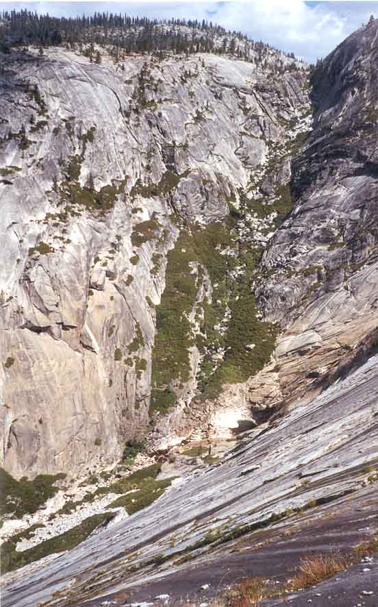
| Tenaya Canyon from Glacier Point | Tenaya Creek just after start |
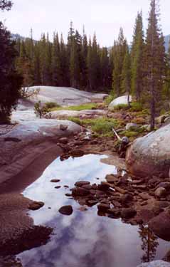
The next morning we drove back over the Tioga Pass and down to Tenaya Lake. Five of us set out that morning from the Sunrise Trailhead (elevation 8160ft) at the south end of the lake: Clancy Rowley, Don Caldwell and myself accompanied by Bob Courtemanche and his friend Steve Cochrane. We followed the Sunrise Trail as it immediately crossed the Tenaya Creek streambed though this had almost no water in it this late in summer. We could have started straight down the creek bed, but it was somewhat more convenient to continue on the Sunrise Trail for a short distance to where it began to climb away from the creek. There, 15min and 0.5m from the start, we left the trail to follow the streambed, gradually crossing to the right or left side where the going was easier over flat rock slabs interspersed with low forest. Above on the right was a steep rocky ridge that separated us from the Tioga Road (this ridge also prevents you from viewing the creek from the Tioga Road). About 40min from the trailhead, the canyon began to deepen and we followed the streambed boulders past an old Park Service sign on the right which read:
WARNING
This is not a trail
Travel beyond this
point is dangerous
without climbing
equipment. Return
to Tioga Road.
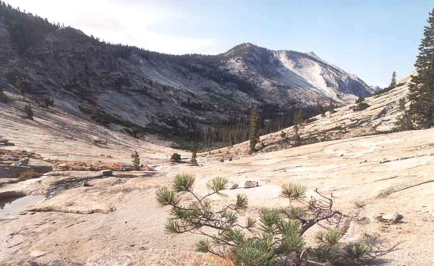
A short distance beyond the sign, we arrived at a crest (elevation 8050ft) where the stream (if it is running) drops into a huge rock-lined bowl, joins another creek coming from the left and then veers to the right. This bowl is an awesome, majestic sight with nothing for hundreds of yards but the glacier-polished rock edged with sparsely forested heights all around. This is where the big-time glacier began. Odd rocks not yet swept to the bottom, dot this other-worldly landscape and here and there the combined action of rock and stream have carved holes in the otherwise smooth terrain. To negotiate the rock bowl we contoured to the left, traversing along more gently sloping rock into the bottom of the huge expanse. Once we reached the stream, we then proceeded down the rock-lined valley toward the west. Soon, the vista before us became even more spectacular as Half Dome came into view far to the west. The accummulation of vegetation in the bottom of the bowl has created a flat forested valley meadow that we bypassed on the right since the going was easier on the rock slabs at the edge of the forest. Here, Bob's experience first became valuable for he identified a single, prominent boulder (the ``Lone Boulder'') ahead of us, up on the profile of a bare rock shoulder on the left side. Half Dome appeared in the distance behind this boulder. It was valuable to fix the location of the Lone Boulder in our minds for, as the forest petered out, it disappearred from view. Here the landscape is all rock and we followed the streambed for a short way until, at an elevation of 7500ft, we came to a lovely little pool where we filtered water for the exertions ahead. We arrived at this point about 3.3m from the trailhead after 1hr 45min of hiking.
 | 
| |
|---|---|---|
| First rock bowl | Yosemite valley from Lone Boulder |
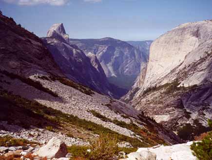
For some time before this, we began to be aware of a huge abyss ahead between us and the massive and sheer face of Mount Watkins beyond that abyss to the north. Tenaya Creek proceeds northwest from here over polished rock and drops about 1000ft via the Pywiack Cascades down into the deep valley ahead. We had read of others who had rappelled down beside the creek, a long time-consuming and exhausting endeavor. Guided by Bob we took a much easier route, perhaps the only route that could be considered straightforward. From the pool where we halted, we left the streambed and climbed the rock slab to the left (or west). Soon the Lone Boulder came into view again and we headed directly for it. When we gained the ridge on which the boulder sits, we were treated to a spectacular vista to the north and west. Tenaya Creek now lay a thousand feet below us at the bottom of a deep gorge with polished rock sides. To the west lay the magnificent Yosemite Valley and its gigantic monuments, Half Dome, Glacier Point and the rest. We paused to enjoy this fantastic place and to gather our strength and resolve for what seemed a dramatic descent ahead.
 | 
| |
|---|---|---|
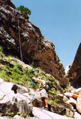
| Rock slab descent | Rappel into Inner Gorge |
This was the point in the hike where Bob's guidance was most valuable for it was hard from above to see the obstacles on the slope below, let alone assess the difficulties. To stray too far to either side of the correct route would be to risk finding yourself on a steep polished rock slope with many hundreds of feet of exposure. The descent down into the valley lay to the left (northwest) of the slope directly below the Lone Boulder. From that waypoint, we had taken note of the talus slope that drops down directly ahead. We identified a substantial band of bushes running up and down the slope to the left or west of the talus slope. Then we descended the talus slope veering to the left to find our way through this band of bushes, with some bushwhacking. On the far side of the band of bushes is another rockslide or talus slope and we began descending this veering toward its left side. Soon we began to discern that we were on the apex of a slight ridge-like prominence in the otherwise flat rock-slab slope. Unlike the slab to either side the rock slope of this prominence is interrupted by patches of bushes all the way to the valley bottom. A single large pine tree near the bottom provided a useful waypoint for the descent route proceeds directly down to this tree. The steepness of the rock slab made for a nervous descent but by maintaining a route with a group of bushes directly below, the discomfort was eased. In several places, I was more comfortable sliding on my rear end while gripping convenient cracks in the rock face with my hands.
Eventually, we reached the large pine tree and followed the now gently sloping rock slab down toward the left. This brought us to another nice pool in Tenaya Creek at the bottom of an attractive sloping cascade. Here by the pool at the end of the descent, we chose to rest and have lunch. We reached this point (elevation about 6250ft) after about 2.5hr of hiking.
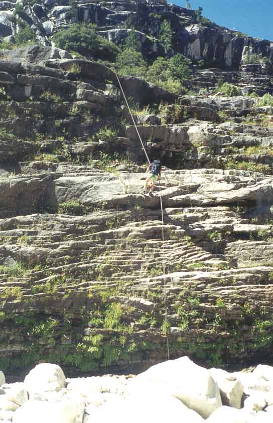
A short distance along the creekbed from the pool, we entered Lost Valley, a bucolic stretch where the stream meanders through a beautiful High Sierra forest. The Lost Valley is only about 0.5m long and so, before long, the going became more rugged with many streambed boulders to negotiate. Then, quite abruptly, we arrived at the top of the Inner Gorge where the stream has cut a dramatic, vertically walled canyon into the valley floor. On the right side of the gorge are several levels of flat ledges that extend horizontally about 60yds along that side of the gorge. Our route led along the large, lower ledge. But before taking that path, we climbed a few feet up to the higher ledge and followed it about 50yds along to a place where S.L.Foster carved his initials in the wall. Foster was one of Bob's predecessors in that he made annual trips down the canyon from 1909 to 1937 and this spot is now known as the ``Initial Ledge''. Someone has also installed a register consisting of a plastic case in an alcove next to the initials and we added our names to it. Then we returned to the head of the gorge, climbed to the lower ledge and followed it along to the rappel point beside a small pine tree growing out of the ledge lip. The anchor is about knee high and consists of two bolts with webbing and a rappel ring; it is relatively easily found. From there it is a straightforward 40ft rappel into the bottom of the Inner Gorge and we reached this point (elevation roughly 6000ft) about 5hrs and 5m from the trailhead.
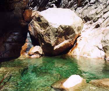
The transit through the bottom of the Inner Gorge was tough going. After one straightforward downclimb, we arrived at a 25ft drop to a large deep pool spanning the canyon. Bob, Steve and Don downclimbed the dry crack on the left though with some exposure. At the bottom they swam the 15yds to the downstream shore. Clancy and I chose to rappel on the left side by the waterfall and waded to the shore. Below the pool the canyon drops steeply through a very rugged section. Here there is much downclimbing and we made our way along on the right, in one place crossing the top of a large rock slab using the bushes for security. Just beyond this rock slab we descended a gully to the streamside only to be greeted by another steep cascade below us. The route from here was not obvious. On our right was a slot between two rock masses which seemed like a dead end. However, by proceeding into this slot we found a small gap between the rock slabs that we could squeeze through to access the scree slope downstream of the cascade. From here we contoured along the right side and some distance downstream found ourselves on a large flat rock shelf with the stream in a gorge on our left. Near the end on the edge where the shelf peters out, we found a rappel anchor consisting of two bolts with webbing and rappel ring. Using this it was a straightforward 70ft rappel down into the bottom of the gorge. There is a non-downclimbable 70ft waterfall just upstream from this rappel so it is not useful to try to descend into the gorge before this anchor location. We reached this point (elevation roughly 5500ft) about 7hr from the start.
 | 
| |
|---|---|---|
| The swim in Innner Gorge | The second rappel |
Downstream of the second rappel the gorge proceeds through a narrow winding slot. The first obstacle was a waterfall that we downclimbed in a slot on the right. This was followed by a sloping 40ft cascade that we downclimbed but should have rappeled using the bolt anchor installed in the rockface to the right of the stream. This cascade is notable for the large, deep hole in the rockface about two thirds of the way down. There is a pool at the bottom of this rappel that can be bypassed on the right. More boulder downclimbing followed until, quite suddenly the slot ended and we emerged into a broad valley bottom at an elevation of 5250ft. This marked the end of the Inner Gorge and it was here that John Muir spent the night after his fall. There is no more technical climbing but we still had a lot of rough ground to cover before reaching developed trails. We reached this point about 7hr 45min from the start.
Downstream of the gorge, the boulder-strewn streambed gradually
became flatter and the going became easier. We passed under the
dramatic Watkins Pinnacles high above us on the right and the
Quarter Domes opposite them on the left. Eventually we picked up
a use trail on the wooded right slope and followed that
for several miles until, eventually, we came to developed trail.
At that point a
footbridge used to carry the Mirror Lake Loop Trail across the stream
but the bridge was swept away by a flood a few years ago.
The maintained trail tracked along the
right or north side of the canyon bottom, passed under Half Dome
and along the side of the now-vanished Mirror Lake. At the
Mirror Lake Visitor Center we came to asphalt road and followed
the signs through the end of the Yosemite Valley development
toward Curry Village. Passing over Clarks Bridge and around the west end
of the North Pines campground we reached the Backpackers parking lot and
our vehicle (elevation about 4000ft). It took us about 10hrs
to complete the 10m hike.
Last updated 9/1/00.
Christopher E. Brennen