THE FAR SIDE OF THE SKY
© Christopher Earls Brennen
RUBIO CANYON
``The long awaited, highly publicized grand opening took place
on July 4, 1893. More than 400 passengers .... made the round
trip that first day to the strains of ``Nearer My God to Thee''
.... Persons crowding the Rubio Pavilion platform stood in
reverent silence as the chariot with the musicians aboard slowly
ascended toward the distant skyline ...''
From ``The San Gabriels'' by John W. Robinson.
Rubio Canyon is a steep and virtually impenetrable narrow canyon which descends the steep southern slopes of the San Gabriel Mountains into Altadena, California. Before the coming of the Europeans it probably saw little of the local native Americans; they were afraid to enter the small, narrow canyons because of the possibility of confronting a bear. But in 1867, a Mexican immigrant, Jesus Rubio, began farming near the mouth of the canyon, using the small but regular stream thatemerged from it to water his land claim. Jesus moved east in 1877 and the land was bought by a Dr. Hall and later, in 1880, by the Woodbury brothers. They began to develop the property and constructed a pipeline down the canyon to bring water from higher up. In doing so they formed the Rubio Canyon Land and Water Company (RCLWC) thatsurvives to this day.
In the early 1890s, the entrepreneur ``Professor'' Thaddeus Lowe had grand plans for the San Gabriel foothills above Altadena. These involved various railways and resorts along a route to Mount Wilson, though this final destination was to elude him. In April 1892, Lowe and his engineer, David Macpherson, began to put their plan into action and, having obtained a right of way from the Woodburys and the RCLWC, they laid trolley lines from Lake Avenue in Altadena up into Rubio Canyon to the point where the Incline Railway Terminus would be located. The Incline Cable Railway from this terminus up to Echo Mountain was completed by July 4, 1893, a remarkable feat we would be unable to match today. At the Terminus where passengers disembarked from the trolleys and boarded the Incline Railway for the ride up to Echo Mountain, Lowe constructed an elegant resort building known as the Rubio Pavilion.
Thaddeus Lowe's resorts on Echo Mountain and at the Alpine Tavern (a further trolley ride up to Mount Lowe from Echo Mountain) are well-known and documented. Today, hikers on the Mount Wilson Toll Road can read about these engineering exploits on explanatory markers placed along that road. Rubio Pavilion is less well known because the site is more remote. Built on a wooden trestle spanning the canyon, the original Pavilion was a substantial two-storey structure containing a hotel, a restarant and, on the first floor, a large dance hall. The dance hall became a particular favorite with the local population and it was the scene of a number of grand social events.
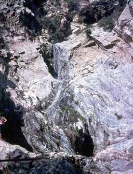
A wooden walkway was also constructed leading up Rubio Canyon so that sightseers could enjoy the many beautiful waterfalls just a short distance upstream of the Pavilion. This was a quite spectacular walk as the surviving photographs and postcards attest. Proceeding upstream one first surmounted several small waterfalls including a 15ft cascade called Bay Arbor Falls thatcan be fairly easily climbed today using footholds and a wire rope on the right side. Just about thirty yards further the sightseers would arrive at the first large waterfall thatconsisted of two substantial drops of 20ft and 30ft with a deep pool on the ledge in the middle. The ledge had a flat sand-covered extension on the right thatmade it a particularly attractive and discrete sun-bathing spot. The two falls were called Ribbon Rock and Moss Grotto and the surviving photographs show a fairly precarious wooden stairway climbing them on the left. Before the recent cataclysm, it was possible to climb a short way up the gully on the right and then access the top of these double falls by means of a rough trail thatcontoured back from the gully into the main canyon.
Just about twenty yards upstream of the lip of Moss Grotto/Ribbon Rock Falls was another set of double falls, this time with the single name of Grand Chasm Falls. These drops were 20ft and 40ft and, until recently, they could be climbed on the left though there was a dangerous exposure at one point. Above Grand Chasm Falls, Lowe constructed a small, masonry dam; this formed a narrow reservoir thathe called Mirror Lake. The water from this pool was used to run a small hydroelectric generator thatprovided power to the Pavilion. But the walkway bridged Mirror Lake and continued upstream where the canyon became very narrow and precipitous. It ascended two more moderate 15-20ft falls called Suspended Boulder Falls and Roaring Rift Falls before reaching its terminus at the bottom of the magnificent 80ft Thalehaha Falls. In total the walkway had more than a thousand steps and, at night, it was turned into an enchanted kingdom by the addition of more than 2000 Japanese lanterns. It proved to be a spectacular attraction which drew tourists from all over the world. The postcards they sent home gained it national and international attention.
But the spectacular nature of the canyon was created by the violence nature would visit on it from time to time. Nature finally caught up with man's adornments one terrible day in February 1909. A severe thunderstorm caused a rockslide directly above the Rubio Pavilion. This brought boulders crashing down onto the canyon-spanning structure, destroying it and killing one occupant. Things were never the same in Rubio Canyon. Eventually, a small transfer shed was built to provide shelter for the passengers transferring from the trolley to the Incline Railway. But Rubio Pavilion and its famous walkway to the waterfalls were to fade into history. The Incline Railway and the Echo Mountain Resort struggled on from one natural disaster to another until they, too, were finally abandoned in 1937. In Rubio Canyon the walkways were swept away early by flash floods and only those hikers agile enough to climb could visit the beautiful waterfalls. The only artifacts that would survive for any time were the more massive concrete foundations of the Pavilion, a few rusty iron anchors for the walkway buried in the rock walls and part of the masonry dam fronting Mirror Lake. But the grandeur of the waterfalls remained and generations of hikers came again and again to enjoy their raw beauty and to bathe in their pools.
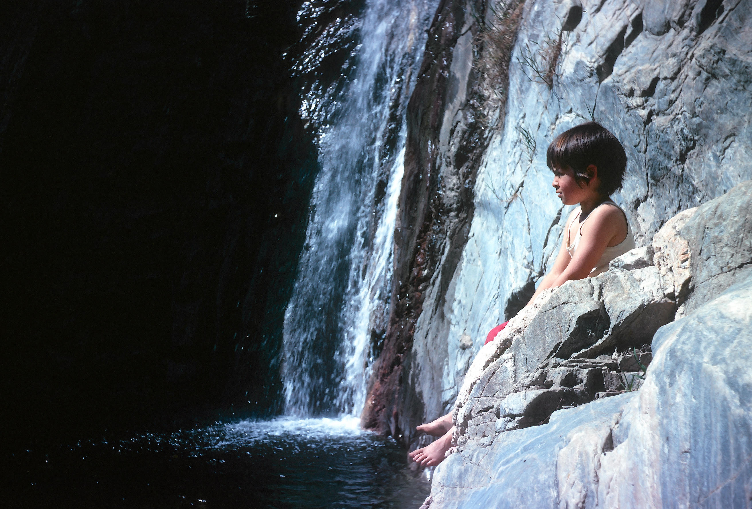
When I brought my family to Pasadena in 1969, it was not long before I discovered the glory of the San Gabriel Mountains. Assigned to look after my two young daughters on Sunday afternoons, I would often take them on hikes and one of our more adventurous expeditions was to Rubio Canyon. There we would hike along the route of the trolley line to the site of Rubio Pavilion. Just downstream of the Pavilion site, the trail had been washed away but a large four-inch water pipe still spanned the gap. The rockface close to the pipe provided handholds to make the crossing reasonably safe but it was necessary to escorted my daughters across the pipe one at a time. Past the Pavilion site, the well-worn use-trail continued up the stream bed. The first waterfall presented no great danger or difficulty. I could let Dana and Kathy climb on their own for it was not high and I could easily catch them if they slipped. But then we would reach the bottom of Bay Arbor Falls and the danger here was more significant. And yet they loved the challenge and so I would attach a rope around each of them in turn and let them climb the right side while belaying them from above. I don't think Dana ever slipped. But Kathy did and I will never forget her dangling on the end of the rope as I lowered her to the ground below. Despite these challenges (or perhaps because of them) we often climbed Bay Arbor Falls so that we could get to the bottom of the spectacular Moss Grotto/Ribbon Rock Falls. This was usually the end point of the adventure though I do remember that once Dana and I climbed the left side of the lower falls (Moss Grotto) to the ledge in the middle. There we swam in the small, deep pool and lay in the sun on the sand. But the climb down was scary and so we never repeated that feat. We did access the small area up above Moss Grotto/Ribbon Rock Falls by climbing the gully on the right and taking the narrow trail that contoured back in the main canyon. But I had nightmares the night after that trip and so we did not repeat it. Other than these moments we had marvellous fun in Rubio Canyon and my daughters treasure those memories to this day. Soon I will take the next generation into what is left of Rubio Canyon. But those will be sadder excursions; it will not be same because of man's clumsiness and foolishness in the summer of 1998.
Early one Sunday morning in February, 1998, Troy and Susan Sette, Garrett Reisman and I drove to the top of Lake Avenue in Altadena, California and set out to climb the steep but well-maintained trail to Echo Mountain. Called the Sam Merrill Trail it begins at an elevation of about 1800ft and switchbacks about 1400ft up the western slope of the ridge thatis Echo Mountain. While several of these switchbacks round the southern end of the mountain none penetrate any significant distance into Rubio Canyon for the eastern slope of Echo Mountain ridge is much more precarious. It took about 1hr 20min to climb the two miles to the remains of the old resort at the top of Echo Mountain. We walked past the ruins of buildings and relics of the railways to where an old set of concrete stairs marks the entrance to a once grand hotel, immediately adjacent to the location of the top station of the cable railway. I remembered the occasion years before when my son and I climbed the route of the Incline Railway and sat on these stairs together to enjoy the achievement and the warm summer air.
After pausing on Echo Mountain, we retraced our steps to the point where Castle Canyon Trail contours off to the right. Here we left the maintained trail and proceeded down the grassy, wooded slope on the northeast side of Echo Mountain. It was a fairly easy descent into Rubio Canyon and we reached the stream in about 10 minutes. Turning to travel downstream, we took pleasure in this open, wooded stretch of canyon thatis home to much wildlife. A use-trail on a series of benches on the right side made downstream travel easy, at least initially. Two small waterfalls were readily negotiated. But then the canyon made an abrupt right turn and the canyon began to change dramatically. To negotiate the abrupt right turn we followed the water pipe a little distance up on the right wall of the canyon.
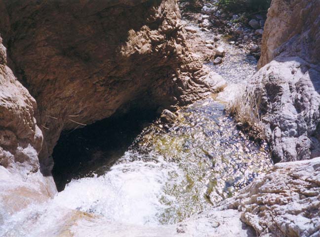
Just downstream of the abrupt right turn, a fair-sized tributary enters from the right. We made our way about 50yds up this tributary to the base of a large multistage waterfall whose lower, vertical drop is about 70ft high; the other, upper section which is visible from Echo Mountain, makes the total drop much greater.
 | 
| |
|---|---|---|
| Diana's bath from above and below | ||
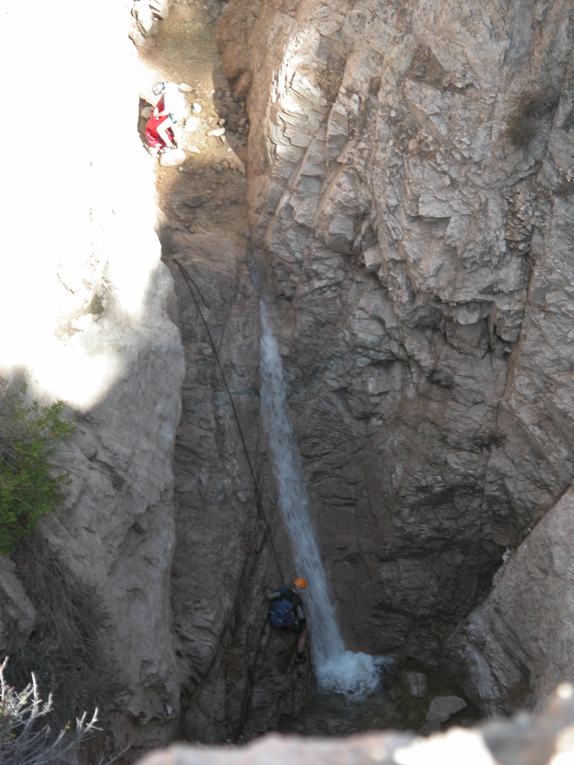
Back at the junction with Rubio Canyon and proceeding downstream, the walls of the canyon became ruggedly vertical and we recognized that we were entering the dramatic and exciting part of Rubio Canyon, the section over which it drops precipitiously during its progress to the valley below. Just after the junction we had to wade for the first time and, about 10yds further downstream, we came to a double waterfall comprising 15ft and 12ft drops with an inviting, large circular pool in between. This is the pool that Professor Lowe called Diana's Bath. A water pipe was suspended above these falls on the right and there was a shelf (spanned by the water pipe) on the right above the circular pool. Climbing up to the pipe we used it to access the shelf and then rappelled from there to the bottom of the lower falls.
 | 
| |
|---|---|---|
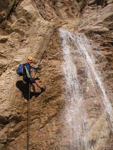
| In Thalehaha Falls | Dry route beside Thalehaha | |
(Photo by Robert Bowman) |
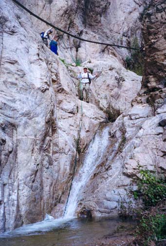
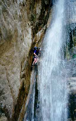
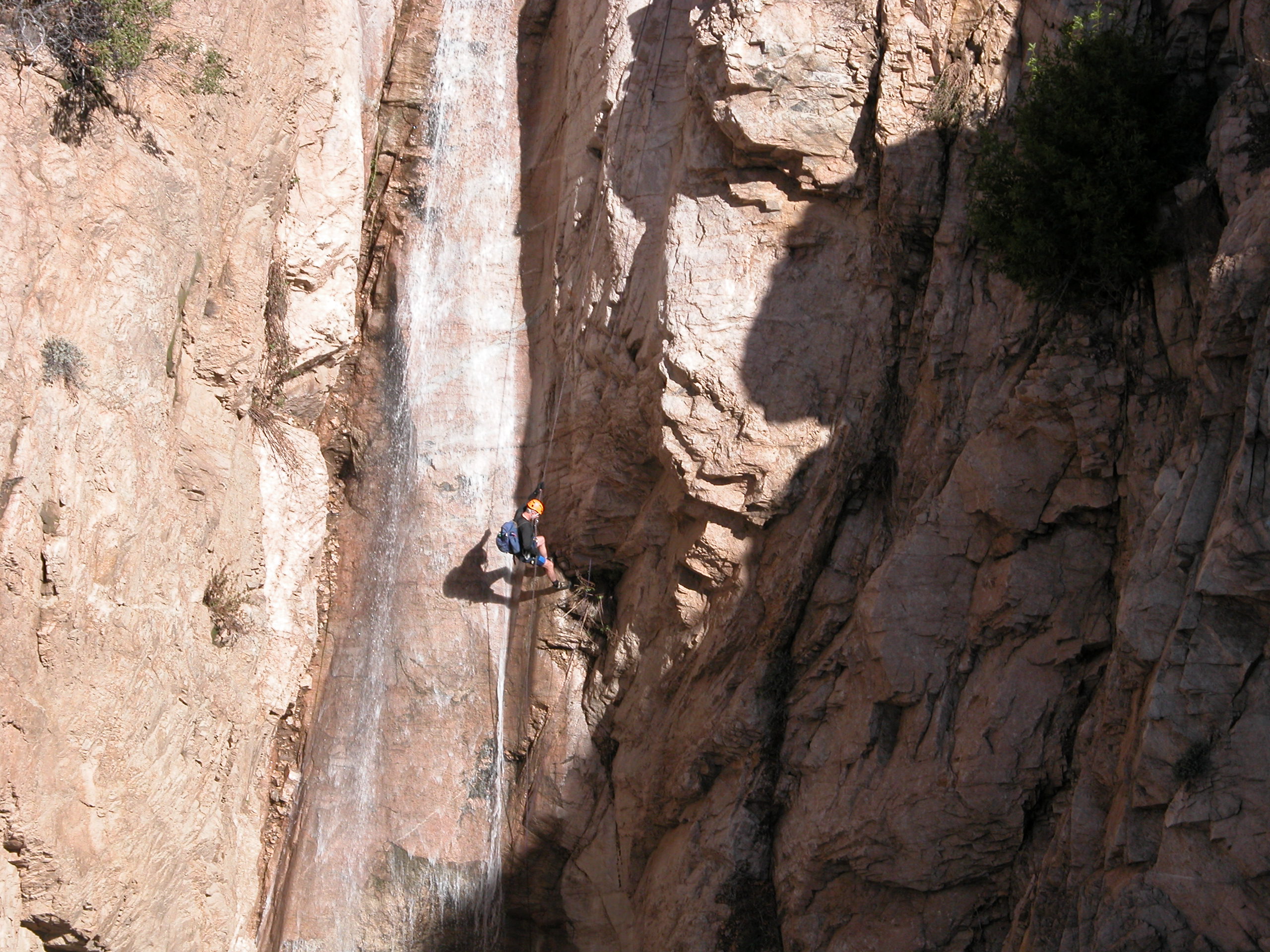
When Thaddeus Lowe's Rubio Pavilion was thriving, the wooden walkways and staircases allowed tourists to come upstream all the way to this point at the base of Thalehaha Falls. In John Robinson's story of the San Gabriels there is a photograph of the Falls (thathe calls Bridalveil Falls) with visitors perched on the wooden walkway. For us there was little opportunity to admire the falls during our descent. And once at the bottom that early spring day, it was hard to warm up. Despite these conditions, one could not help but pause to admire these beautiful falls as they cascaded down into the dark grotto where we now stood.
 | 
| |
|---|---|---|
| Roaring Rift Falls | Lower Grand Chasm Falls | |
(Photo by Robert Bowman) | (Photo by Mark Duttweiler) |
Another 40yds down the very narrow slot-like canyon we came to the remains of the small masonry dam thatLowe built to form the reservoir he called Mirror Lake. Of course, the reservoir had filled with sediment and so a flat sandy bottom had long ago replaced the ``lake''. The masonry dam formed the top lip of Grand Chasm Falls, a two-stage cascade with drops of 20ft and 40ft. An exposed use-trail climbed up to a tree above the lip on the right and it was thereby possible to access a ledge from which it was easy to climb down a scree slope to the bottom of Grand Chasm Falls. We chose the safer method of descent and rappelled down Grand Chasm using as an anchor a small tree about 10ft back from the lip.
 | 
| |
|---|---|---|
| Ribbon Rock/Moss Grotto Falls | Pool between Ribbon Rock & Moss Grotto |
About 30yds further downstream, we came to the last major hurdle, a beautiful, two-stage waterfall with drops of 20ft and 30ft. Lowe gave separate names to the two parts of this waterfall and called them Ribbon Rock Falls and Moss Grotto Falls. Another account suggests he named them for his wife and called them Leontine Falls. We were tired and cold by this time and so, instead of rappelling, we chose to take the old, badly eroded trail thatcontoured around to a gully on the left and thus descended the gully to the bottom of the falls.
Now on familiar ground we proceeded downstream, climbed down Bay Arbor Falls and made our way out of the canyon to the trailhead. It had been another glorious adventure down one of the most precipitous and spectacular small canyons in the San Gabriel Mountains. A wild and violent place of tortured cliffs and sculpted chasms. A raw and marvellous beauty tinged with history and human challenge.
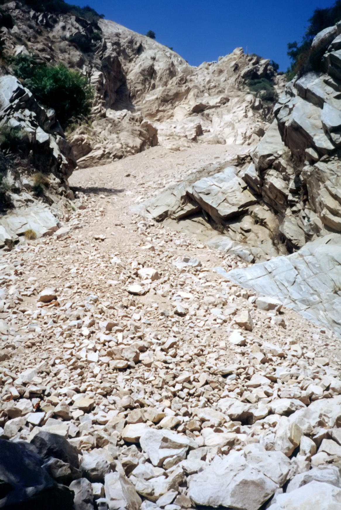
Several months later, in April of 1998, engineers in the employ of the Rubio Canyon Land and Water Association (RCLWA) began work on a project to repair the pipeline thatcarried water from high up in Rubio Canyon down to their reservoir at the canyon mouth. The RCLWA would later claim that the line had been damaged by the 1994 Northridge earthquake; if so that damage was not apparent to us during any of our adventures in the canyon. The RCLWA received one million dollars from the Federal Emergency Management Agency (FEMA) in order to carry out the repairs. Whether they also obtained the necessary environmental impact permits is still not clear. What is clear, as later events would reveal, was that instead of just repairing the pipeline the RCLWA enlarged the project and decided on a major re-routing of the pipeline. Thus, a few months later, they created a new trail through National Forest land from Echo Mountain down to a point high on the west wall of Rubio above Grand Chasm Falls. And here on this highly unstable slope of fractured rock they began, incredibly, to cut a roadway across the steep slope at the top of the wall. To do this they transported a backhoe by helicopter up to a cleared platform at the end of their trail. And so they began to hack away at the mountain with this backhoe perched three to four hundred feet above the canyon bottom. When even that failed they resorted to dynamite. Eventually the inevitable happened. A huge section of the side of the canyon was shaken loose and the resulting rock slide crashed down into the canyon below, covering up Grand Chasm, Moss Grotto and Ribbon Rock Falls in the process. By some odd chance the platform where the backhoe was perched survived and sat there at the top of the slide path for several months thereafter, ironically revealing the cause of the catastrophe to any who might happen by.
 | 
| |
|---|---|---|
| Slide covers Ribbon Rock/Moss Grotto | Machines on high shelf |
It was Troy Sette who first described the rock slide to me and I must confess I listened to his account with considerable scepticism. But a few weeks later, driven by curiosity, I set out to investigate for myself and so started up the Rubio Canyon trail one Sunday afternoon in September 1998. Almost immediately I came upon a large, unsigned notice warning hikers of the danger of rockfalls in the canyon. Continuing on past the Rubio Pavilion site, I climbed the familiar Bay Arbor Falls and rounded the right hand turn in the canyon just before Ribbon Rock/Moss Grotto Falls. As I did so the most incredible site revealed itself. The entire 50ft of this glorious waterfall was now covered in rock. And more than this. The rockfall extended almost as far upstream as I could discern from this vantage point. Clearly Grand Chasm Falls were also covered and perhaps more upstream. It took several minutes for me to absorb the horror of the sight before my eyes. And so at first I focussed on the foreground where a wooden sign immediately before me read: ``WARNING. HAZARD AREA. UNSTABLE SLOPE. NO OUTLET''. Again the notice was unsigned. No indication of how or by whom this obscenity had been perpetrated.
I sat down to try and regain my composure and looking up I could now see that a large part of the west wall of the canyon above the Grand Chasm Falls had collapsed, producing an enormous rockslide that had created a huge rock dam in the canyon and covered up at least four beautiful waterfalls. From the bottom, I estimated the elevation of the top of the rock dam to be about 250ft above where I stood. And then, looking more closely at the scar on the west wall, I could discern the top of a machine perched on the ledge directly above the scar. (I was later to find that machine was a backhoe.) I was overwhelmed by a combination of incredulity and shock. What on earth was a backhoe doing up on that unstable slope and how on earth did they think they could avoid causing some catastrophe by operating up there? Some of the answers to these questions would come later. For now all I could think of was to determine the full extent of the disaster. Some careful tests showed me that it would be foolhardy to try to climb the face of the still-settling rockslide. But I was able to safely make my way up along the side of the rockslide, by treading mostly on original ground. From the top of the slide, I could look south right into Altadena. Turning around I looked down into the partly filled narrow chasm upstream of the dam and downstream of Suspended Boulder Falls. The canyon bottom was about 60ft below me. Water was clearly still flowing through the rock slide itself, perhaps following its original course beneath all that rock. But if the interstices between the rocks ever filled up with debris and other sediment, the lake behind the new dam would be about 70ft deep and would extend up to the base of Thalehaha Falls. If the dam then failed, this huge mass of water would then go crashing down the canyon toward Altadena. I went home stunned.
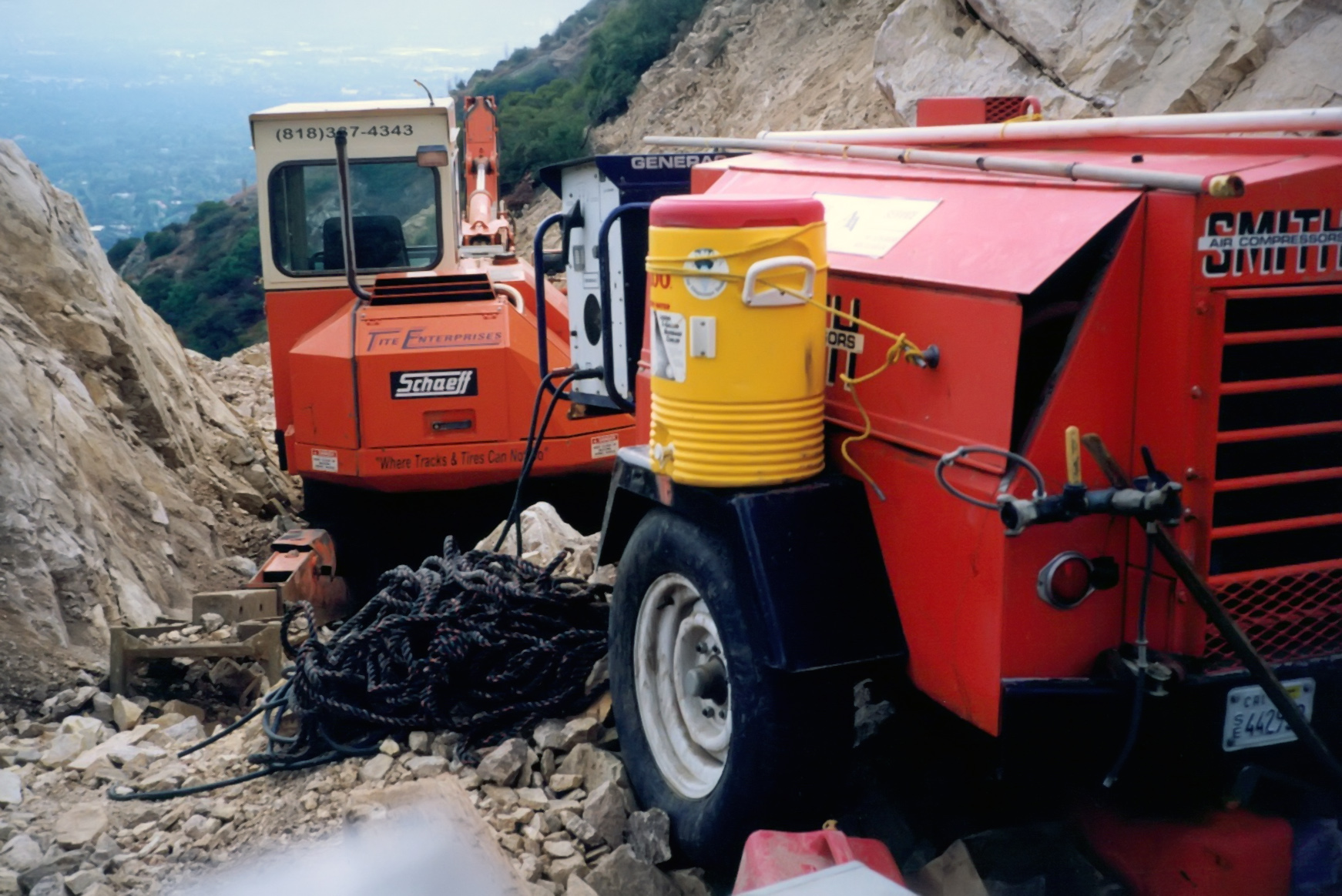
The following weekend I set out to investigate further. This time I climbed Echo Mountain as I had done earlier with my young friends and thus made my way down into upper Rubio Canyon. Proceeding downstream as we had before, I negotiated Diana's Bath and arrived at the top of Thalehaha Falls. Looking down I could see a fair amount of debris (old pipes and some crates) scattered at the bottom of the falls. Moreover earth appeared to be falling down the west wall from above where I was standing, covering everything with a coating of brown and grey dust. I could not see the rock dam and so I decided to try to determine the source of the debris and dust. Backtracking about 20 yards, I was able to find a use-trail thatclimbed the west wall toward the source of the debris and dust. First I came upon a pile of old four-inch diameter water pipes, some of which were in the process of tumbling down to the canyon below. A little further on, the use-trail led, not surprisingly, to the ledge where the backhoe still stood. For the record it was a Schaeff enscribed with the name Tite Enterprises and the telephone number 818-367-4343. Immediately behind the backhoe stood a large, two-wheeled air compressor. Various ropes, gas cans, tool boxes and other equipment lay scattered around as though the site had only temporarily been evacuated. I could also make out, above me, the rope thatthe workers had used to help them descend to this point from the mountain above.
Now I could understand what had happened. South of the backhoe site and immediately above the scar vacated by the rockslide, I could see that the engineers had been hacking a sizeable horizontal slot into the steep and unstable slope above the west wall of Rubio Canyon. In the process they had to remove a very large volume of material from the slope above the cutting and they had blithely dumped all of this rock down into the canyon below. Additional material fell from below the horizontal cutting as the dynamite and the backhoe shook loose large quantities of the fractured rock. In the end they cut a roadway about 15ft wide and about 50yards long into the side of the mountain. It was now obvious to me that the purpose of the work was to replace the section of the pipeline that ran across the mountain high above the glorious waterfalls of Rubio Canyon. And all that they had succeeded in doing was in destroying that priceless natural heritage. I went home very sad and quite angry and waited for the news to break in the local papers.
But I had a long wait. It was not until some six months later that concerned owners of homes near the Rubio Wash and angry hikers, forced the Rubio Canyon Land and Water Association to hold a public meeting to answer questions. Troy and I went along to find out more. All that I learnt I had already figured out from my explorations of the site. Troy brought additional evidence in the form of used blasting cap casings. Much anger was vented by the hikers and much concern was expressed by the homeowners. The Association promised answers at some indeterminate time in the future. I heard some argue that the hillside was unstable and would have come down naturally. The evidence does not support that opinion. Indeed, it is clear that over the past hundred years and more, only gradual erosion has occurred, with the exception of a few large boulder falls.
Otherwise, we were told little and as I write this (March 1999)
it remains to be seen whether any corrective action will be attempted.
But it is almost impossible for me to imagine that they could ever
remove the huge amount of rock that is covering up
the waterfalls. Both the immense quantity and its
inaccessibility make it seem an impossible task. And so I fear
that the precious natural and historic heritage of Rubio Canyon has
been lost forever. And I weep for that. And I mourn that I will never
be able to climb up there with my grandchildren to enjoy those
glorious waterfalls and to tell them tales of men like Thaddeus Lowe
who loved Rubio Canyon and, by and large, respected that beauty.
Instead I must tell them tales of more modern men whose ignorance
and callousness destroyed that heritage forever.
Last updated 7/30/99.
Christopher E. Brennen