THE FAR SIDE OF THE SKY
© Christopher Earls Brennen
RATHLIN
``I have travelled through great beauty
To some measure of understanding
You cannot ask for more than that.''
Anonymous.
Rathlin island off the north coast of Ireland is a storied place of myths, massacres and abundant wildlife. Its isolation of old, maintained by the fierce north Atlantic, has been extended into modern times by an episodic and uncertain ferry service and this isolation has preserved this quiet and lovely place for the enjoyment of todays occasional visitors.
Perhaps the most widely known legend of Rathlin concerns the Scottish king Robert I, known as Robert the Bruce. During his early struggles to establish dominion over Scotland, Robert suffered a number of serious setbacks. Fleeing from a defeat at the Battle of Strath-Fillan in 1306, Robert took refuge in a cave on the island of Rathlin. There he was bemoaning his fate when he began to watch a spider struggling to build its web within the cave. Many times the spider failed, but each time it began again and, in the end, succeeded in creating the web. Inspired by the spider's example, Bruce emerged from the cave and, reviving his campaign, went on to win a famous victory at the Battle of Bannockburn in 1314. Crowned Robert I, he had a long and successful reign as King of Scotland. But he will forever be known to the world (and in countless children's books) as a classic example of persistence.
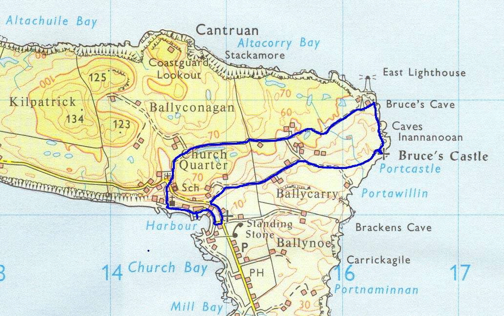
Though much doubt surrounds the historical accuracy of the legend and it's location, the Rathlin people point to a sea-cave on the rugged northeast headland of the island and identify this as ``Bruce's Cave''. I learned that it was at the bottom of a sheer 200ft cliff and just south of the East Lighthouse that guards this storm-tossed corner of the North Atlantic. Atop the cliff not far away are the remains of a castle that was built in the 12th century and occupied by Robert the Bruce during his travail. Today's guidebooks claim the cave is only accessible by boat and only during calm seas, a rarity around Rathlin. This story recounts my expedition to seek out and visit Bruce's Cave.
 | 
| |
|---|---|---|
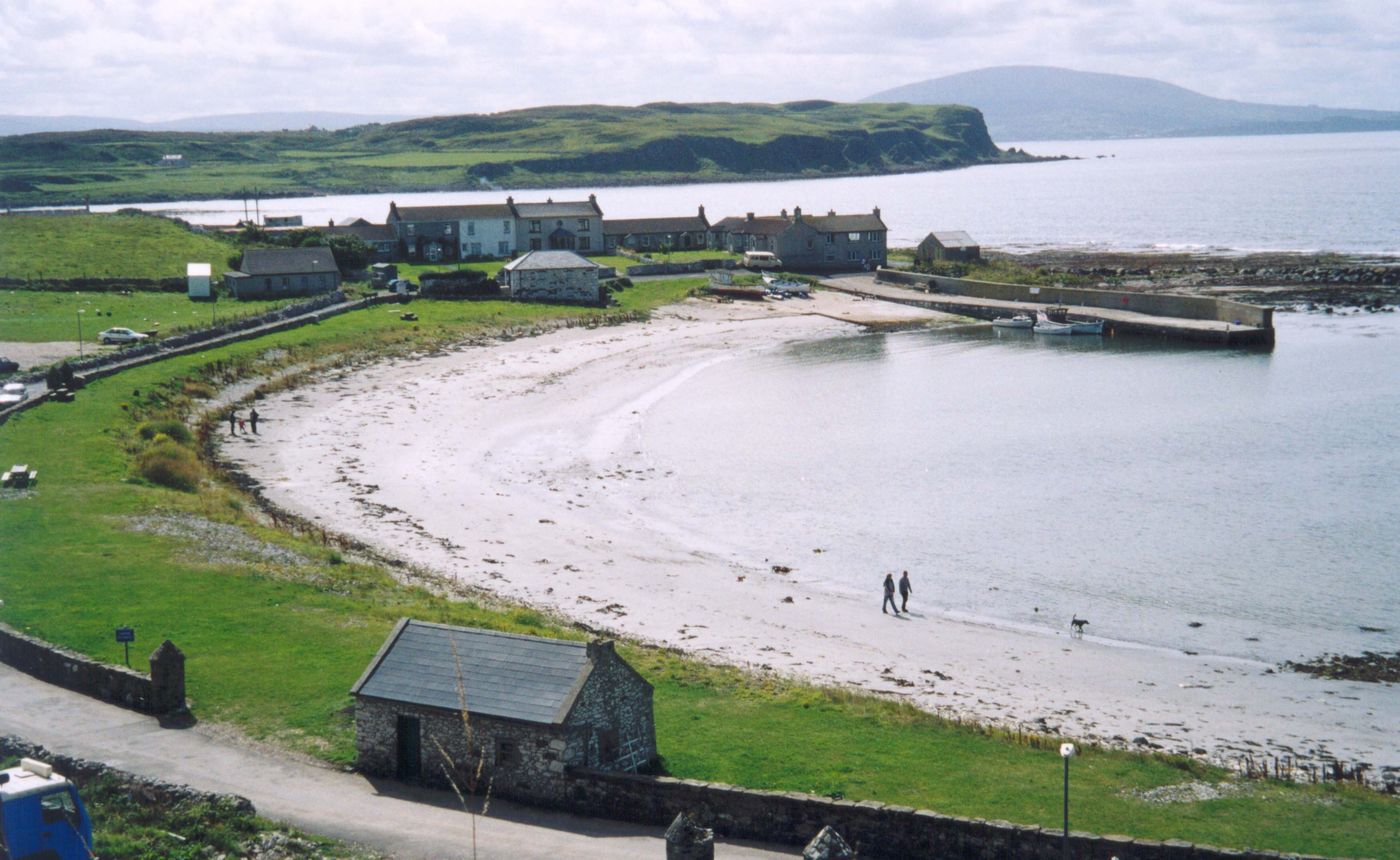
| Church Bay harbor | East Lighthouse |
It was Sept. 2004 and I had driven to Ballycastle to spend the day on Rathlin Island. The ferry was much larger than I expected. A landing craft type vessel, it had lowered its gangway onto the slope of the launching ramp in Ballycastle harbor and was ready to accept as many as half a dozen vehicles. But there were no vehicles this morning. Only about a dozen people had bought tickets in the harbor office and had wandered on board the Caledonian MacBrayne ferry (http://www.calmac.co.uk/) for the 10.30am trip across to Rathlin island. As we waited to depart a seal played among the harbor rocks and a shearwater stood watch on the harbor wall.
The 6mi trip from Ballycastle to Church Bay on Rathlin Island takes a little over 30min. The currents in this channel can be quite fierce; they create visible patches of turbulence that the ferry seeks to avoid. However, the L-shape of the island means that Church Bay, within the L, is sheltered from both the ocean and the wind. The currents and frequent storms have resulted in many wrecks around the coast of Rathlin and make this a popular diving venue. One prominent wreck within Church Bay is that of the warship HMS Drake which was torpedoed here by a German U-boat in 1916. It is now populated by large conger eels. Other sea life greets the visitor in Church Bay harbor, home to a large population of seals who bask on the rocks next to the tourists.
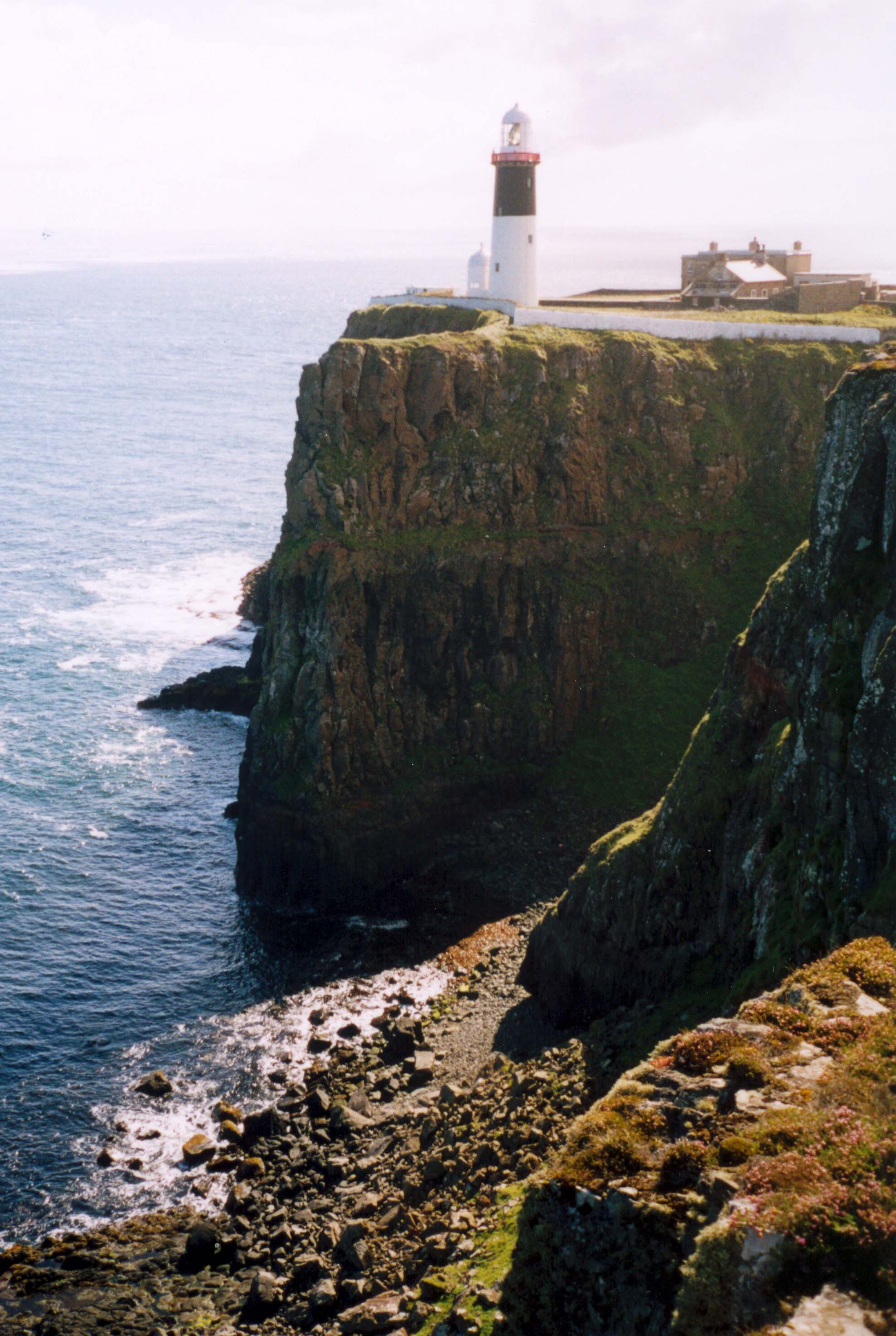
The sun was shining as I disembarked and turned left away from the village. I stopped briefly at the lovely Church of St.Thomas, built in 1722, and maintained today with exquisite simplicity and elegance. Just past the church the road turned inland, climbing steeply toward the flat plateau on top of the island. Continuing on through a four-way junction at the Roman Catholic Church, the road turns east and, within 0.5m, becomes a gravel-surfaced driveway that leads to the East Lighthouse on Altacarry Head. Here the plateau is exposed to the elements and the grassy slopes that characterized the land further southwest are now replaced by heather-covered heathland. The East Lighthouse itself, built in the 1850s, sits atop 200ft cliffs that plunge vertically down into the sea. It is famous as the site of Marconi's first radio transmission made between here and Ballycastle in 1898. The lighthouse and associated buildings are contained within a walled compound to which access is forbidden but that is not a problem for the hiker exploring the cliffs to either side of the headland.
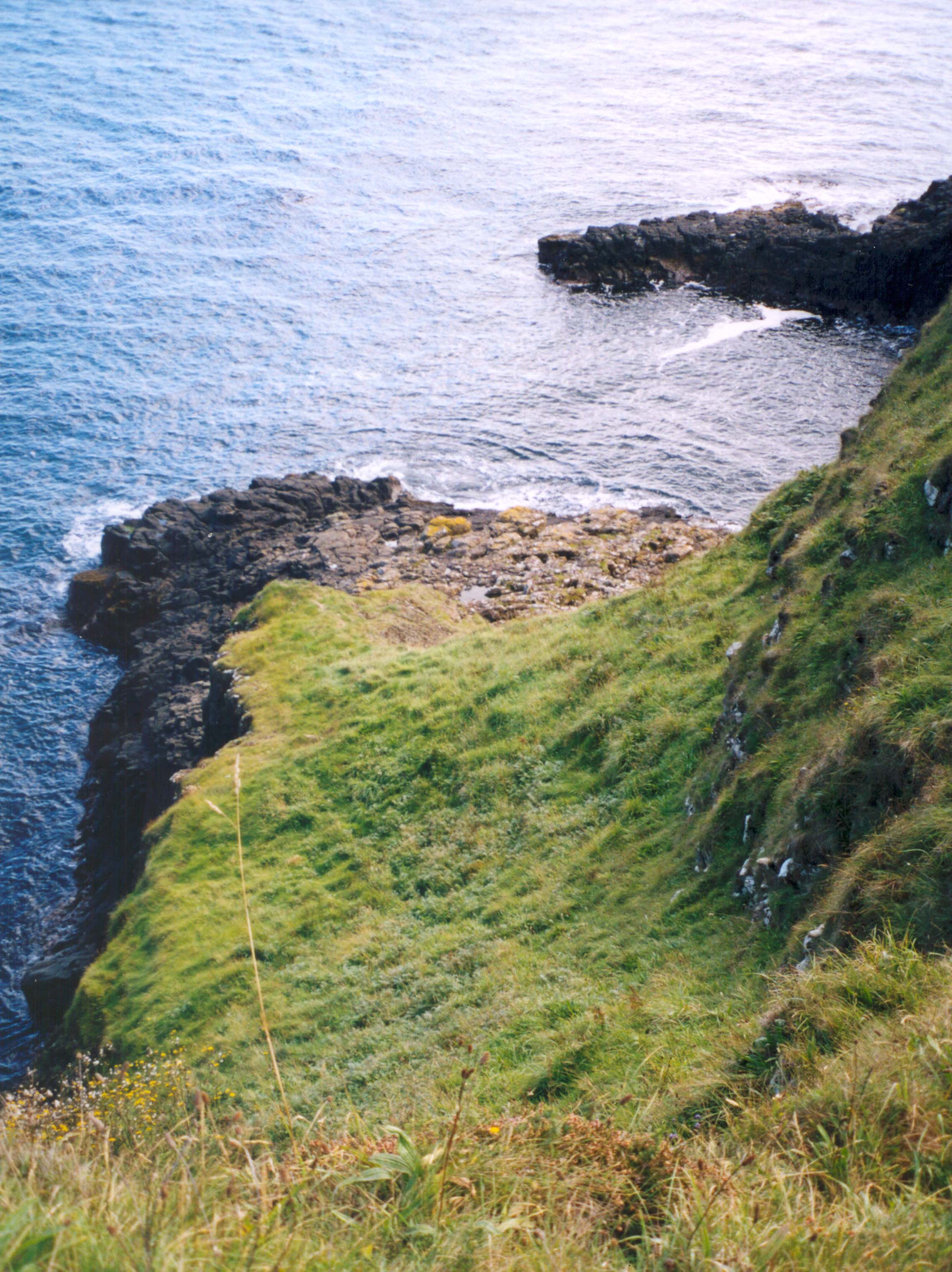
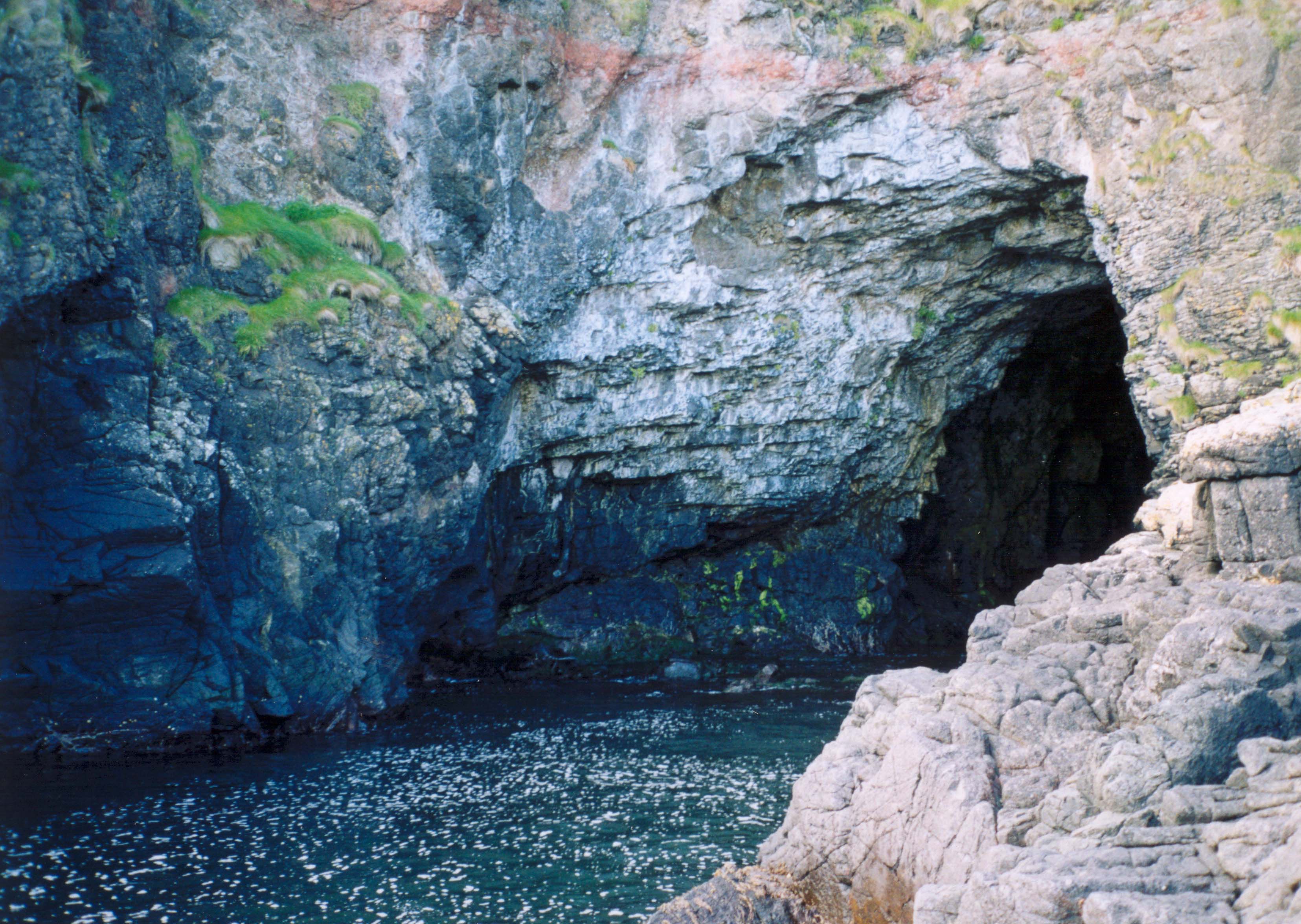
After a brief visit to the coast north of the lighthouse, I made my way along the southern wall of the compound and began a detailed inspection of the cliffs that drop straight down into the ocean at that point. My purpose was to locate Bruce's Cave from the clifftop and, if possible, to find a way to climb down to it. The slippery grass that grows everywhere made it quite difficult to safely get a view over the edge of the cliff but by venturing onto several promontories and looking backwards I came to the conclusion that there were no caves directly beneath the lighthouse. I then continued my precarious survey working my way southwards along the cliff's edge. About 100yds from the lighthouse, I came to a slight break in the cliff where a steep, grass-covered gully descended to a rocky ledge far below. I could see that there were substantial sea inlets to either side of my clifftop vantage point. The inlet to the right or south of the gully seemed very promising and the only likely location of Bruce's Cave that I had found so far. Trouble was that the steep grassy route down to the ledge veered right across the top of a vertical drop into the left inlet. But I planned out the footholds and handholds in detail and, leaving my pack at the top, began the downclimb. In the end, I descended to the ledge with little difficulty though the route might be much harder on a wet day. Reaching the broad ledge, I looked right and there it was - a beautiful and deep sea-cave, Bruce's Cave. A deep and navigable channel ran into the cave and culminated in a rocky beach about 20yds inside the cavern. I was able to tightrope along ledges on the right all the way to the cave entrance. I could have readily reached the beach by wading but chose to stay dry for the island had much that I had yet to see. It was clear that the cavern extended some distance inland but I could not discern quite how far that was.
 | 
| |
|---|---|---|
| Route to Bruce's Cave | Bruce's Cave |
I returned to the sunny ledge and sat down to enjoy this remote place and my success in reaching the cave. It had turned out to be a beautiful day, sunny and calm. I thought about the Bruce, the spider and my own resolve. Sometimes I seem to set my mind on objectives that only I think have value; and I do admit to a single-minded tenaciousness in pursuing those goals. But, at the very least, these whims bring me to places of undeniable beauty and to experiences that are deeply gratifying. Maybe, above all, these whims have opened windows into myself.
 | 
| |
|---|---|---|
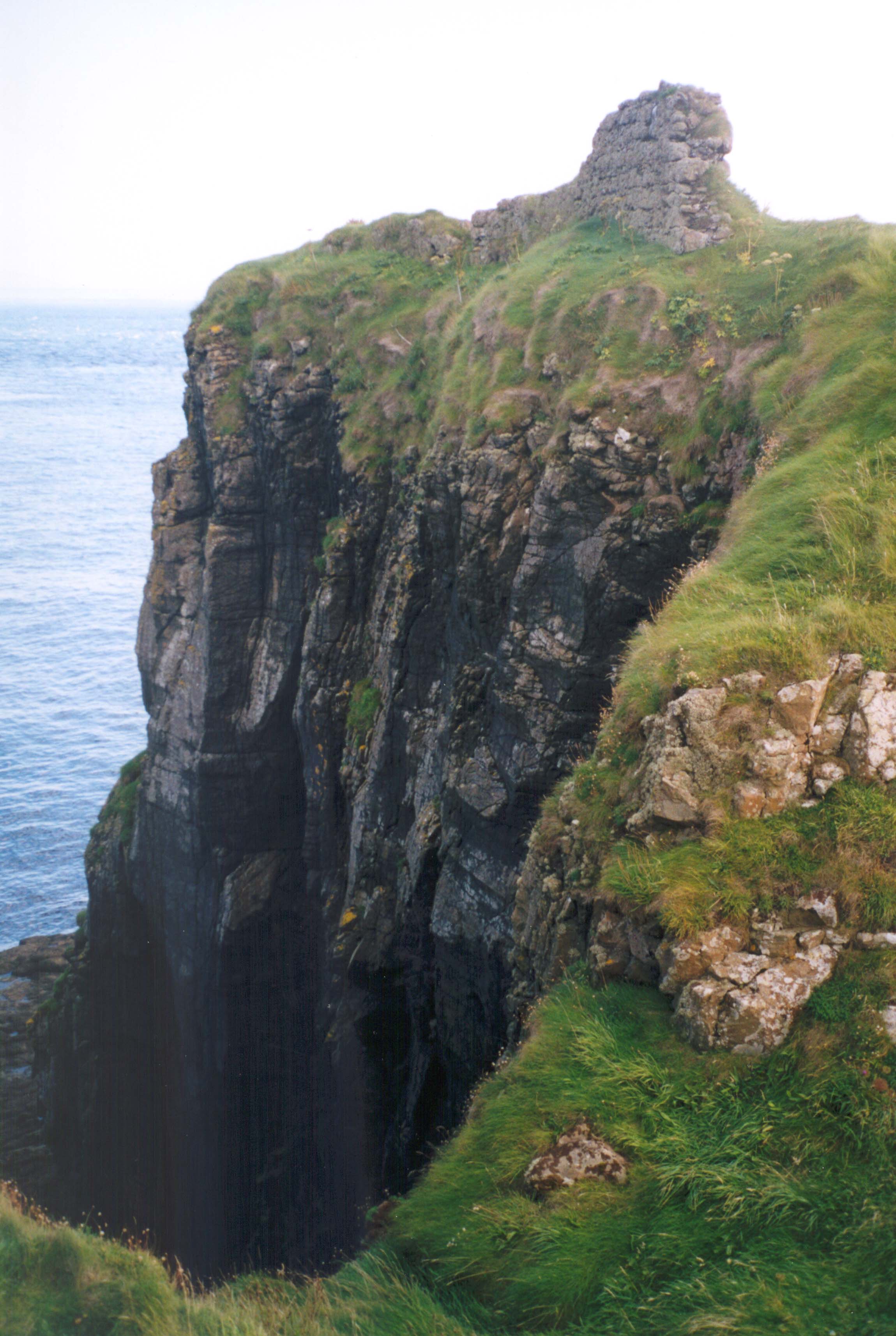
| Bruce's Castle | Route to Bruce's Cave |
But time was awasting and there was much yet to see on this lovely island. I gathered myself for the climb back to the cliff-top, an ascent that was, as always, much easier than the descent. Continuing southward, I soon spotted the little remains of Bruce's castle on a small plot of land almost completely cut off from the clifftop heathland. The remains consisted of two small sections of wall at the edge of the cliff-ringed sea stack. A narrow land bridge allowed access to the castle from the mainland and I made the crossing to pay homage to Bruce. I also thought of the hundreds of native Irish that sought refuge here in 1575 and were massacred by the English army of the Earl of Essex.
From the castle, I hiked across country following a faint path
in a western direction. This linked up with the end of a
dirt road that took me back to the southern asphalt road back to the
village. The excursion to Bruce's world had taken just 2hrs.
During lunch at the village pub, I learnt of a bus tour that would
take me to the seabird sanctuary at the other, western end of the island
nearly four miles distant. The tour had been scheduled to depart about an
hour ago but had
been delayed because both batteries aboard the bus were dead. The owner
operator was around the corner
slowly recharging the batteries. There was a depressing prediction that it
would take at least another hour to complete this task. I decided to start
walking knowing that I could flag down the bus if and when it caught up
with me but also knowing that
there was insufficient time to hike to the west end and back. In the event,
the bus did catch up with me after about a mile and I enjoyed a delightfully
rustic bus tour of the west and southern ends of the island before returning
to the village in time for the 3.30pm ferry back to the mainland.
Highlights of the bus tour included the precipitous seabird sanctuary
at the dramatic western headland
and the two ruined buildings at the southern tip. One belonged to the
smugglers and the other to the coastguard whose primary task was the
prevention of smuggling. Only in Ireland.
Last updated 9/20/04.
Christopher E. Brennen