THE FAR SIDE OF THE SKY
© Christopher Earls Brennen
HAVASUPAI
``Come dance with the westwind
and touch on the mountain tops,
Sail o'er the canyons
and up to the stars ....''
From ``The Eagle and the Hawk'' (1971), song by John Denver and Mike Taylor.
Up in the northwest corner of Arizona, far to the west of the popular rim venues of the Grand Canyon, lie several American Indian reservations where access is limited and the impact of the dominant white culture has been controlled with some success. One of these tribes, the 600-strong Havasupai live in a village called Supai that is far beyond the end of the road and deep within the bowels of the Grand Canyon. A visit there is not only a spectacular scenic experience but also a narrow window into a special and different culture. One weekend in March 2004, I hiked into this rugged land and among these unique people; this is the story of that adventure into time, space and the human experience.
On Sunday March 21, 2004, I turned off an old and legendary highway, the historic Route 66, at a point just east of Peach Springs in the emptiness of northwestern Arizona, and drove across the flat, open range of the Hualapai Indian Reservation toward the rim of the Grand Canyon. Indian State Secondary Road 18 crosses the Coconino Plateau; it is a lonely highway with no services, and almost no sign of human presence except for the occasional small herds of cattle. There is little to do for 62 miles but count the mile markers. Then over the last couple of miles the road begins to dip down into a shallow gully until, quite abruptly, the earth opens up ahead and you come to the edge of the upper rim of the greatest canyon on earth. The road contours around the top edge of the cliff for a short distance before arriving at a long, strung-out parking lot known as Hualapai Hilltop. This is the end of the road for all vehicles. The road you have travelled is the only asphalt on the Havasupai Indian Reservation and has penetrated just a short distance into their territory. The rest of their domain is made up of wild and beautiful, often inaccessible, canyon country with cliffs, mesas and steep ravines. A few of the canyons are blessed with perennial spring water that brings the desert to life and feeds a rich bottom land where plants can grow and people can live. Far down below Hualapai Hilltop is one such eden, the village of Supai, home to most of the Havasupai tribe. The Grand Canyon country has been the land of the Havasupai people for hundreds of years, as long as their collective memories can recall. Their village of Supai lies at a bend in Havasu Canyon where the canyon broadens and the river has left a wide flood plain. In ancient times they lived here in the canyon bottom during the spring and summer, tending to their gardens and their flocks. In the fall and winter they would move up onto the plateau for hunting and gathering. When the US government created the Havasupai Indian Reservation in 1882, it confined the tribe to a tiny area around the village, denying them their range lands on the plateau. After many years this injustice was corrected in 1975 when Congress returned nearly two hundred thousand acres to the tribe forming the current Havasupai Indian Reservation.
Today tourists are also drawn to this land. The same healthy stream that emerges from the ground at Havasu Springs to give life to the Havasupai, also creates a series of magnificent waterfalls that attract visitors from all over the world. Rich in calcium carbonate, the river coats all that it touches with hard limestone. In the streambed this leads to travertine rock formations that create shelves and lips with crystal blue-green pools and cascades. Hence the name Havasupai, the ``people of the blue-green waters.'' Most of these attractions lie below the village where the walls of Havasu Canyon close in and deepen before finally flowing into the Colorado River. But to get there the visitor must pass through Supai.
So it was that I loitered at Hualapai Hilltop, sorting my camping gear and chatting with returning hikers to glean information on the circumstances down below. During the popular spring season the Hilltop is a busy place. Several Havasupai-operated pack stations cater to both the tourists and the residents, carrying visitors and their baggage down to the lodge in the village and transporting goods to the villagers. In contrast, a rudimentary helicopter service also shuttles back and forth to the village, landing at the edge of the cliff only yards from the pack mules.
In the 1860s the adventurers who commandeered the high Coconino Plateau from the Havasupai and other tribes, created huge sparsely-vegetated ranches on which to run their cattle. Some families got rich off this land, among them the Babbitts, and with that hegemony came political clout. More than a century later that influence was still in place and one member of the family, Bruce Babbitt, became governor of Arizona and then Secretary of the Interior in the Clinton administration. In doing so he ironically gained supervision of the Bureau of Indian Affairs and therefore responsibility for the welfare of the Havasupai and their reservation deep in the great canyon. But Babbitt Ranches continued to own and operate huge tracts of land on the plateau; in particular they continued as owners of Cataract Ranch that included the land at the head of Cataract Canyon. Cataract is a major tributary that flows into Havasu Canyon some 35 miles from the ranch house and just a short distance above the village of Supai.
The one precious resource needed for the cattle to thrive on the high plateau was water. Not that it did not rain. However, rain tended to come in torrential downpours and would quickly run off the rock and soak into the desert leaving little for drier times. The solution was to build dams to hold the water. In the early days there was virtually no regulation of these structures and ranchers built crude, unengineered berms to hold the water. Even after the dams came under the jurisdiction of the state of Arizona in 1973, there were so many of them in remote locations that oversight and evaluation lagged far behind. Cataract Dam was never examined even though the state law mandated inspection every five years. Moreover the structures tended to grow with time as ranchers sought to strengthen and expand their facilities. So it was with the Cataract Ranch. The Babbit's dam started out life as a modest structure just a few feet tall. But by 1929, when the State of Arizona passed a law requiring that all dams be registered, James E. Babbitt complied stating that the dam was 15 ft tall. By the time of the events recounted here, it had somehow grown to 20ft. While this additional 5ft difference does not seem like much, in fact, it implies more than a doubling of the stored volume of water.
Late in February 1993, torrential rains came to the Coconino Plateau. The runoff was compounded by a series of storms. A deluge of water gathered strength as it was funnelled down into Cataract Canyon and came raging into the makeshift dam, causing it to overflow and to begin to disintegrate. As the dam failed an enormous wall of water went crashing down Cataract Canyon toward the Havasupai village. Fortunately, someone had thought to warn the tribe who, as night fell, scurried to their refuges of higher ground in the nooks and crannies of the red sandstone walls surrounding the village. The tidal wave hit the village sometime after midnight. It carried away just about every structure the Havasupai owned, their entire centuries-old irrigation system, their cattle, fields, crops and orchards. It scoured their hallowed burial grounds scattering their ancestor's remains down the canyon. Even the beautiful waterfalls and blue-green pools were violated. The ancient travertine retaining walls that took so many years to deposit were sliced way in seconds leaving muddy sloughs where the blue-green pools had been. The destruction was total and cataclysmic. As the flood subsided and the Havasupai ventured down from their refuges they found only a sea of mud sprinkled with a few belongings and dead animals.
The tribe was accustomed to occasional floods but nothing like this had happened in their long tribal memory. However they knew there was no alternative but to go to work with their hand tools to rebuild the village. Of course they applied to the Bureau of Indian Affairs for disaster relief. The response from Babbitt's federal agency was truly underwhelming. It was two months before the BIA authorized $823,000 for cleanup and repair of the tribe's damaged infrastructure and even then the money was not released until the angry intervention by Senator John McCain. Not only was the money nowhere close to that needed to restore the infrastructure of Supai but the grant also stipulated that none of the funds could be used to generate improvements over preflood conditions. There was little hope of improving tourist facilities, and therefore boosting the tribes principal source of revenue. To this day (2004) the trail to the spectacular waterfalls remains in dangerous condition. Meanwhile, the federal government was eagerly helping Babbitt Ranches assess damage to Cataract Dam. The Department of Agriculture sent a seven-person team to to survey the area, create a contour map and compute capacity data for the reservoir behind the private dam. That assistance came while Bruce Babbitt was secretary of the Interior. Some of it came while he still held an ownership interest in the Cataract Ranch and, therefore, the dam itself. Six months after the flood Bruce Babbitt sold his interest in the Cataract Ranch; it is unclear how much responsibility he had for the actions of the Cataract Ranch leading up to the dam failure. It makes one wonder whether anyone in government, state or federal, cared about the poor Havasupai.
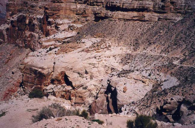
|
|---|
| View from Havasupai Hilltop |
But I knew nothing of this as I started down the steep, arid switchbacks that descend the cliff below the Hualapai Hilltop. It was a lovely spring day, warm but not too warm, and I felt sure the 8 mile downhill hike to the village would pass quite easily. After dropping about 1000ft in just over a mile, the trail reaches the wash in Hualapai Canyon. For the rest of the way, the descent is gradual and the hiking in the gravel of the wash is easy going. The vertical, sculpted sandstone walls gradually increase in height and the frequent overhangs provide welcome shade from the midday sun. This is a barren world of rock with almost no vegetation except for the occasional tree sustained by a small spring. However, all this changes at the end of Hualapai Canyon where it flows into Havasu Canyon (whose upper reaches are known as Cataract Canyon). Just upstream of the confluence in Havasu Canyon, a gushing river emerges from the ground at Havasu Springs. This river irrigates the canyon bottom and allows a profusion of desert plants and trees. Turning downstream beside the river, the trail from here on is in the welcome shade of willow, tamarisk and cottonwood trees, the verdant and riparian canyon bottom in marked contrast to the earlier trail setting. Just 1.5 mi from the confluence, I came to the outskirts of the Havasupai village.
The village of Supai is situated where Havasu Canyon briefly broadens and allows extensive farming. But the red walls of Supai Sandstone still tower over the village providing security and shelter, at least against some dangers. Two red sandstone columns that protrude above the western wall are called Wii'igliva and are considered male and female figures that protect the Havasupai people. It is said that their demise would presage that of the tribe. The village may be unique in the United States, being isolated and therefore insulated from the outside world. There are no motor vehicles, no gasoline fumes, no asphalt roads and very little concrete. The pace of life is gentle and rural; horses and dogs are everywhere. The wooden homes are spread out over the available land, individual plots being defined by trees and barbed wire fences. There are two small stores, a school, a church, a post office and a health clinic. Off to one side is a lodge for tourists (usually booked up for months ahead). Tourism provides a large fraction of the tribal revenue. All visitors must check in at the tourist office in the center of the village, right next to the small field that serves as the helicopter landing pad. There all campers must pay for a visiting permit as well as camping fees that total about $40 per person. I sat on a bench in the center of the village to get a sense of the place and to enjoy a ice lollipop. I had the impression of a proud people who have had some success in maintaining their culture and way of life by partially isolating themselves from the outside world. Family groups strolled by, returning from some errand or visit elsewhere in the village. I listened to their strange-sounding native tongue of which they are very proud; it was not transcribed to written form until about 1980. Men, women and children on horseback would saunter by; signs explicitly prohibted cantering or galloping near the village center. There did not seem to be the atmosphere of depression, alcoholism and domestic violence that I had sensed on other Indian reservations. The helicopter made frequent trips back and forth from the Hilltop, ferrying everything from tourists to bags of fertilizer. This despite the fact that the several fully loaded mule trains had passed me on the way down from the Hilltop. The juxtaposition of the noisy, bustling helicopter and the ageless, serene world of the Havasupai seemed jarring; I felt resentful of the noise, the imposition and the intrusion represented by the helicopter. Despite the convenience I wondered if the Havasupai did not also resent it.
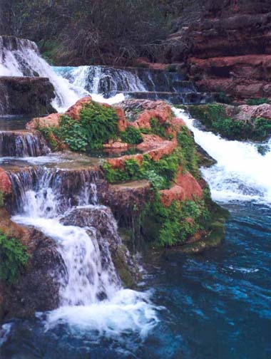
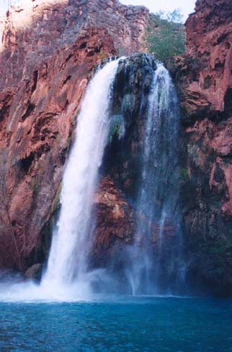 | 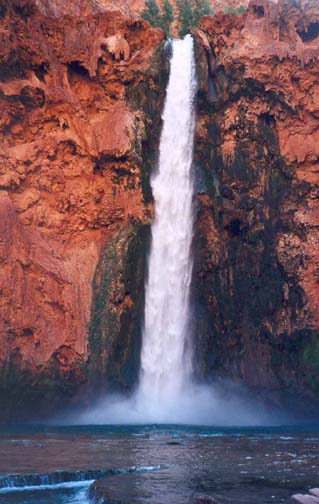
| |
|---|---|---|
| Havasu Falls | Mooney Falls |
It was late afternoon, long after the last helicopter flight, before I bestirred myself and headed out of town bound for the campground about 2 miles downcanyon. A short distance beyond the village, the canyon narrows and deepens and the river begins a series of steep drops that also create some of the loveliest waterfalls to be found anywhere in the world. From here on to the Colorado River, Havasu Canyon is beautiful, its red sandstone walls contrasting with the greenery in the canyon bottom and the blue-green waters of the irridescent river that flows through it. About one and a half miles from the village I came to the first of these waterfalls. Navaho Falls are actually a series of cascades. You first spy these through the trees from the right side of the canyon when passing an unstable riverbank from the 1993 flood that still poses a real danger. To get a close look at Navaho Falls you must proceed a little further down canyon and then work your way back upstream along the riverbank. Just downstream of Navaho Falls, the trail crosses a footbridge to the left bank of the river and almost immediately arrives at the edge of the cliff above the spectacular Havasu Falls, This magnificent waterfall drops about 100ft into a crystal blue-green pool. It is a beautiful place that alone is worth the hike down from the hilltop. The trail descends steeply to the left of the falls and a branch winds its way down to the edge of the pool. Here a swim is more than welcome on a hot day.
The campground is just downstream of Havasu Falls and consists of many tree-shaded sites with tables stretched out along both sides of the river in a narrow part of the canyon with vertical walls on both sides. Many of the sites lie along the stream banks. However there is only one purified water faucet along the west wall of the canyon; though the river appears clean it is downstream of the village and is probably unsafe to drink. It took me less than 4 hrs of net hiking time to reach the campground from Hualapai Hilltop, a distance of 10 mi. It had been a long hot day and I was pleased to lie down beside the stream and drift into early sleep to the sound of the gurgling water.
Eager to explore further downstream, I awoke with first light and leaving my pack at the campsite, started down the trail through the rest of the extended campground. Just beyond the last site, I came to a dramatic overlook beside the awesome Mooney Falls, some 200ft of free-falling water plunging into another blue-green pool. The cliffs on both sides span the entire canyon and allow no easy descent. Herein lies a tale.
Some of the earliest Europeans to explore this canyon country were prospectors, driven by the lure of instant riches. In 1879 a group of miners filed claims in Cataract Canyon and began an exploration down into the lower reaches of this remote region. Among the prospectors was a man named Mooney, even more adventurous than his colleagues. Over several years, the group pushed further and further down Cataract/Havasu canyon. But they were unable to get past one particular obstacle, a huge drop-off where the river plunged over a 200ft cliff in a narrow section of the canyon. Over the centuries the river had deposited vertical, travertine cliffs on both sides of these falls. One day during their 1882 expedition, Mooney set off determined to negotiate this hurdle. He borrowed a belt and a rope to aid in the downclimb. He also removed his boots which he left at the top of the drop-off. No one knows exactly what happened next but he fell during his descent and ended his days at the bottom of the cliff. None of his fellow miners was willing to follow him down. They could see his still body at the base of the cliff but there was little they could do. Mooney did not move and so they reluctantly concluded that he had died in the fall. One of the prospectors tossed the rope and his boots down beside the body, commenting that it was the only funeral they could give him.
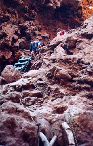 | 
| |
|---|---|---|
| Descending beside Mooney Falls | Beaver Falls |
When the miners returned the following year they found that Mooney's body, like everything else exposed to the river, had become encrusted with limestone. But his boots were no longer lying where they had been thrown. Then one of the miners, Young by name, noticed a Havasupai Indian wearing familar footwear and persuaded the young man to show him the way to descend the cliffs. The route was extremely exposed, too dangerous for any of the miners to attempt the descent. However, they noticed a hole that, if widened to form a tunnel, would allow a start for the descent. After considerable excavation over that year and the next, the miners created two short tunnels that bypassed the steepest part of the cliff and allowed them to reach the bottom. There they were finally were able to give Mooney a decent funeral, burying him on a island in the big pool below the waterfall. Appropriately that waterfall was given Mooney's name and today is a major tourist magnet in Havasu Canyon.
The route cut by those miners more than a century ago continues to be used to this day though the installation of chains, bolts and ladders has added considerably to the safety of the adventure. The downclimb consists of several small tunnels and platforms chizelled out of the travertine rock with steps added to ease your way. The tunnels are followed by steep rock steps with chains and, finally, several wooden ladders. Though the climb is straightforward, extra care must be taken when you near the bottom for there the spray from the falls wets the rock. At the bottom there is a marvellous plunge pool and a great view of the falls. Mooney's burial island is not immediately obvious.
Down canyon from Mooney Falls the trail sees less used though it is still a beautiful canyon. The path wends its way along the left bank of the river between vertical, red walls. About 10min from Mooney Falls, you come to the first river crossing, where the wade is usually no more than thigh-deep. Just a few minutes later the trail crosses back to the left bank and then, just before Beaver Falls, it again crosses to the right side. Just downstream of this third crossing the canyon becomes quite narrow and, to follow the trail, I had to climb a short way up onto a bluff on the right side. On top of this rise there were several stone shelters in the cliff at ground level, whose purpose was unclear. Beaver Falls are below this bluff to the left. To get a good view of these smaller but very photogenic cascades I had to find a steep downclimbing route just downstream of the falls. I was much taken with these lovely falls. Smaller in height than the much-visited waterfalls further upstream, Beaver Falls are an intricate weave of cascades interspersed with pools and foliage. I lingered in this lovely setting before reluctantly deciding to start back up the trail. I might have continued another 4mi to the Colorado River at the Havasu Rapids. But my time was short for I had to get back to the Hilltop before nightfall.
From Beaver Falls it took me about two and a half hours to hike back up to the village. I arrived there in the heat of the day and, as I had done on the way down, I sat down to absorb the comings and goings in the village. It was a long way back up to the Hilltop and I was not particularly looking forward to that four hour, hot and dusty hike. As I sat under the shade of a big tree, the helicopter landed in the small grassy field, disgorged a group of tourists, loaded some mail and was soon airborne again, swooping up the canyon between the sandstone walls. It was then that a quite inappropriate thought crossed my mind. Maybe I could get a ride back up to the Hilltop and avoid that unpleasant hike. Within a few minutes this became a full-fledged plan and I looked about for anyone who might be the local representative of the helicopter company. All I could find was a young girl seated at a rusty desk beside the chain-link gate, the entrance to the helicopter field. She did not seem to speak much English. She did however run into a nearby house and fetch a young man who asked me to sign a list on his clipboard and informed me that I should pay up top. Within minutes the helicopter was back, my backpack was loaded and I was strapped into the front seat beside the pilot. As we rose into the air over the village, the guilt I felt about contributing to this jarring intrusion into life of the Havasupai was swept from my mind. Exhileration took over as we swooped up Havasu Canyon between the sandstone walls and seemed to barely clear the rim as we rose up over the surrounding plateau. Below me I could see groups of hikers trudging along the trail on their slow way to the Hilltop. It was a fantastic feeling of freedom, manoevering eagle-like through this spectacular vertical terrain. Above us still was the upper cliff below the Hualapai Hilltop. As the pilot approached our destination, he seemed to fly directly at the cliff just below the rim only at the last moment rising above it and setting down on a small concrete pad. It was an exhilerating conclusion to a marvellous adventure and one that left me inextricable torn between the serenity of the village and waterfalls and the spine-tingling excitement of the helicopter ride. I still can not resolve that conflict in my soul.
In preparing this account, I gratefully acknowledge the
information that was taken from Tom
Chester's website,
http://sd.znet.com/~schester/grand_canyon/index.html
and from the February 1995 story by John Dougherty in the Phoenix New Times
entitled "Village of the Dammed" (see
http://www.phoenixnewtimes.com/issues/1995-02-23/news4.html ).
Last updated 4/10/04.
Christopher E. Brennen