THE FAR SIDE OF THE SKY
© Christopher Earls Brennen
THE GREATEST CANYON OF ALL
"We are now ready to start on our way down the Great Unknown. We have but a month's rations remaining. We have an unknown distance yet to run, an unknown river to explore. With some eagerness and some anxiety and some misgiving we enter the canyon below and are carried along by the swift water."
Journal of John Wesley Powell for Aug.13, 1869.
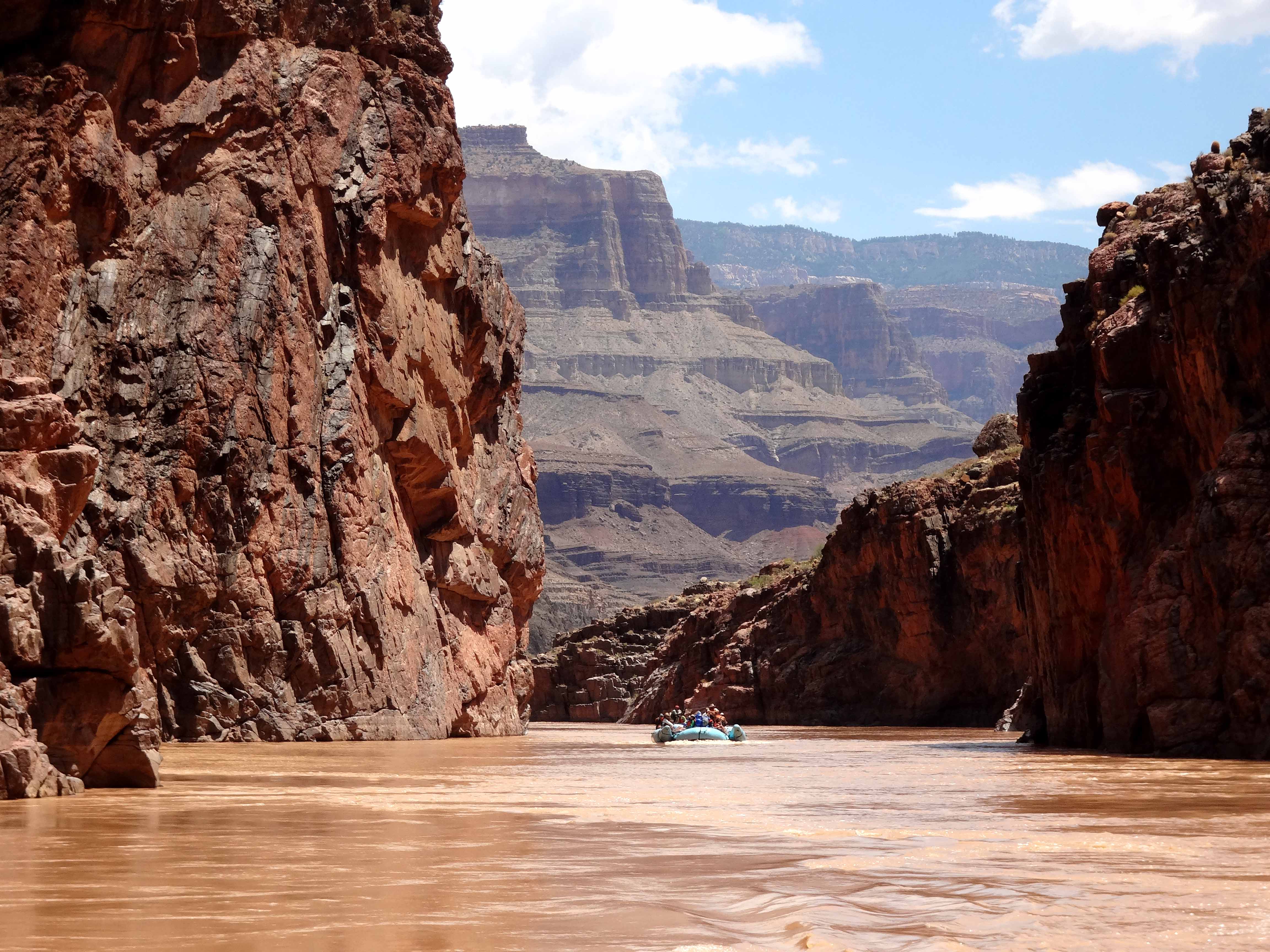
What could it have been like to find yourself in this huge, seemingly endless canyon of the Colorado with no knowledge of what lay ahead? We cannot but be amazed by the extraordinary bravery, indeed foolishness, of this one-armed veteran of the Civil War as he set out into the unknown, as he ventured to traverse one of the last great unknown land areas on this earth. Even today, with almost every square inch of the Grand Canyon National Park mapped, explored, and travelled, it still an awesome feeling to set out from Lee's Ferry to ride hundreds of raging rapids during a descent through the greatest canyon on earth. And to do so knowing that the next road to touch the Colorado is 225 miles downstream!!
During adventures in my younger days I had, of course, travelled to the Grand Canyon, even down to the Colorado River. I had watched the rafts filled with modern river runners glide by at Phantom Ranch and plunge down the notorious Lava Falls below the Toroweap Overlook. But I had never had the time or money to spend on the rafting trip down the length of the greatest canyon of all. Finally, at the age of 71, when my knees had few miles left in them, I decided to fulfil this ambition, this desire that had lingered ever since I first read Powell's "Exploration of the Colorado River and its Canyons". It was a spur-of-the-moment decision in the summer of 2013 when I had several weeks without obligations. After at brief internet search, I called Grand Canyon Whitewater and asked whether they still had a space available on their 7 day motorized rafting trip through the length of the canyon. One could do a shorter motorized trip by beginning or ending at Phantom Ranch, roughly the halfway point. But these involved strenuous hikes to or from the canyon rim; moreover, if I was finally going to take the plunge, it seemed only appropriate to do the whole canyon (or at least all the exciting parts). Of course, to do the trip properly, in the manner of John Wesley Powell, one should do it in the non-motorized fashion with the smaller, oar-guided boats. But as other stories in this collection have described I seemed to have great trouble staying in the smaller boats and, in any case, the 14 day trip through the entire canyon was longer than I could manage. I had anticipated that the commercial trips, having strict limits on the number of participants, would sometimes find themselves with just one unfilled space. And so it was that the good folks at Grand Canyon Whitewater were able to accommodate me as the last, the 28th passenger on a trip leaving just 5 days after my telephone call (the motorized trips comprise two boats, each with 14 passengers and two crew).
So it was that I found myself driving the 500 plus miles to the remote hamlet of Marble Canyon, Arizona, in August of 2013. There, early on the morning of Aug.3, a motley group of 28 passengers met with the leader of the expedition, Brock DeMay of Grand Canyon Whitewater and boarded a van for the short ride down to Lee's Ferry and the banks of the Colorado River. There we met with the three other crew members, John Dunn, the helmsman of the second boat, his assistant, Ted Decker, and the volunteer helping Scott in the lead boat, Joanne Nissen. We would get to know all of them in the days that followed. Throughout the busy, hard-working seven days of the expedition they maintained a very pleasant, friendly attitude which added greatly to the enjoyment of all the passengers.
Lee's Ferry at the point where the Paria River meets the Colorado is one of the few places along this river system where it is possible to get to the shoreline without descending cliffs. The Colorado emerges from the Glen Canyon gorges very briefly before plunging back into the depths of Marble Canyon. In the pioneer days it was just about the only place where migrants and adventurers could cross the Colorado without either going far to the north or far to the south. A Mormon by the name of John D. Lee set up and operated the ferry in the early 1870s and it remained an important river crossing from the 1870s until 1928. Lee himself was executed in 1877 for his part in the Mountain Meadows Massacre. Today the road from the Marble Canyon Lodge down to Lee's Ferry follows the route of the trail on the west side. The more precipitous trail on the east side, in the Navaho Indian Reservation, has almost disappeared as a result of rock falls.
 | 
| |
|---|---|---|
| Lee's Ferry preparations | Passing under Navaho Bridges |
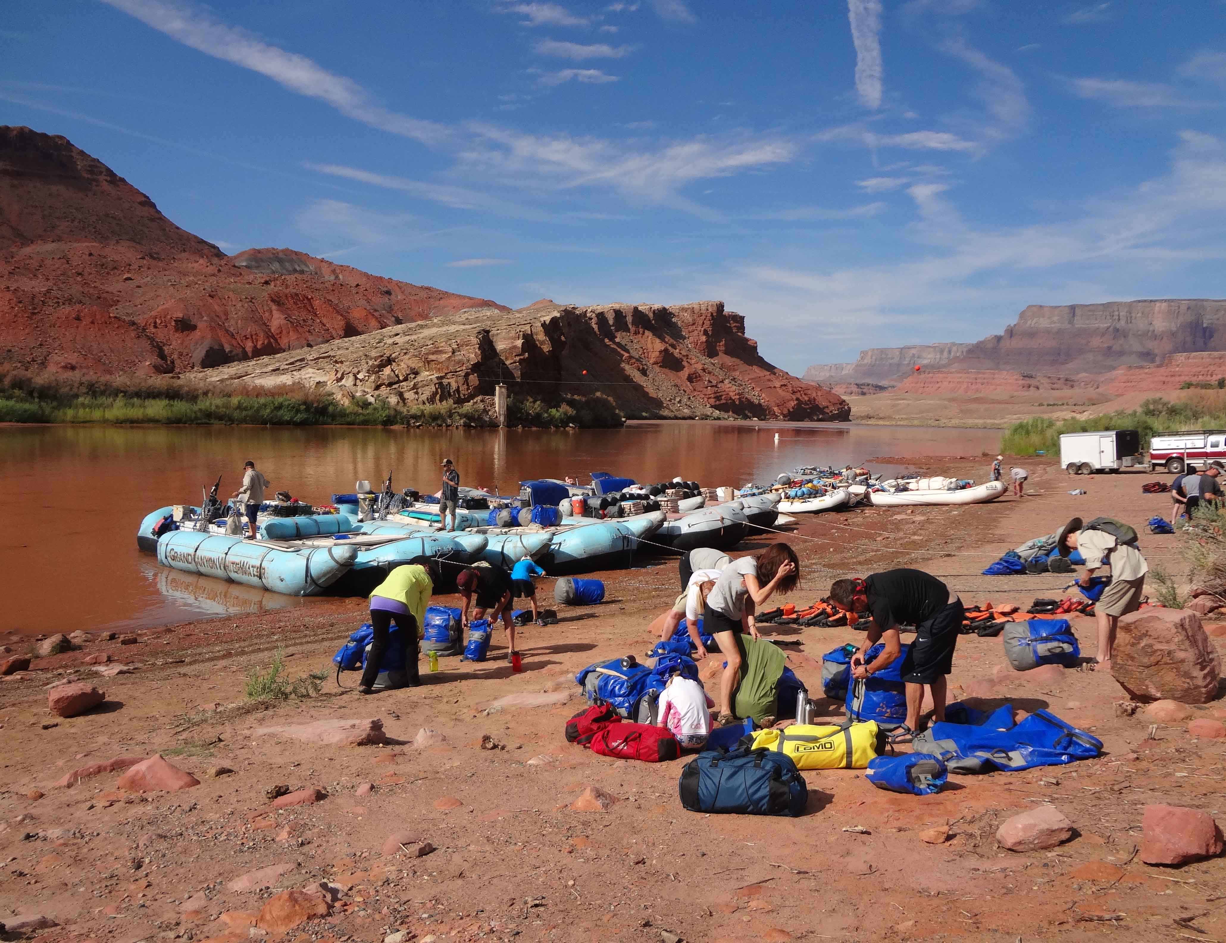
On the morning of our departure the beach at Lee's Ferry was a hive of activity as several rafting trips prepared for departure. We had been instructed to bring the minimum of personal effects packed in a small duffel bag plus a much smaller bag of stuff we might need to access during the day (such as cameras, sunscreen and light waterproof clothing). Grand Canyon Whitewater issued each of us with a large waterproof drybag containing a sleeping bag, small pillow and groundsheet to which we added our duffel bag. This packed "night bag" was then stowed on board one of the rafts and would not be accessible during the day. We were also issued a second, small drybag for our day stuff and this we would take with us on board the rafts. Both the large and small drybags were numbered so that we, the passengers, could readily claim our own stuff when we landed for the night. A great quantity of other equipment and supplies was also firmly stowed on board including campbeds and folding chairs for each of us as well as the cooking and toilet gear. All of this had to be unloaded each evening and loaded up again the next morning; this was done with great efficiency by the four crew aided by a chain gang of passengers transferring the gear from the shore to the boats and vice-versa.
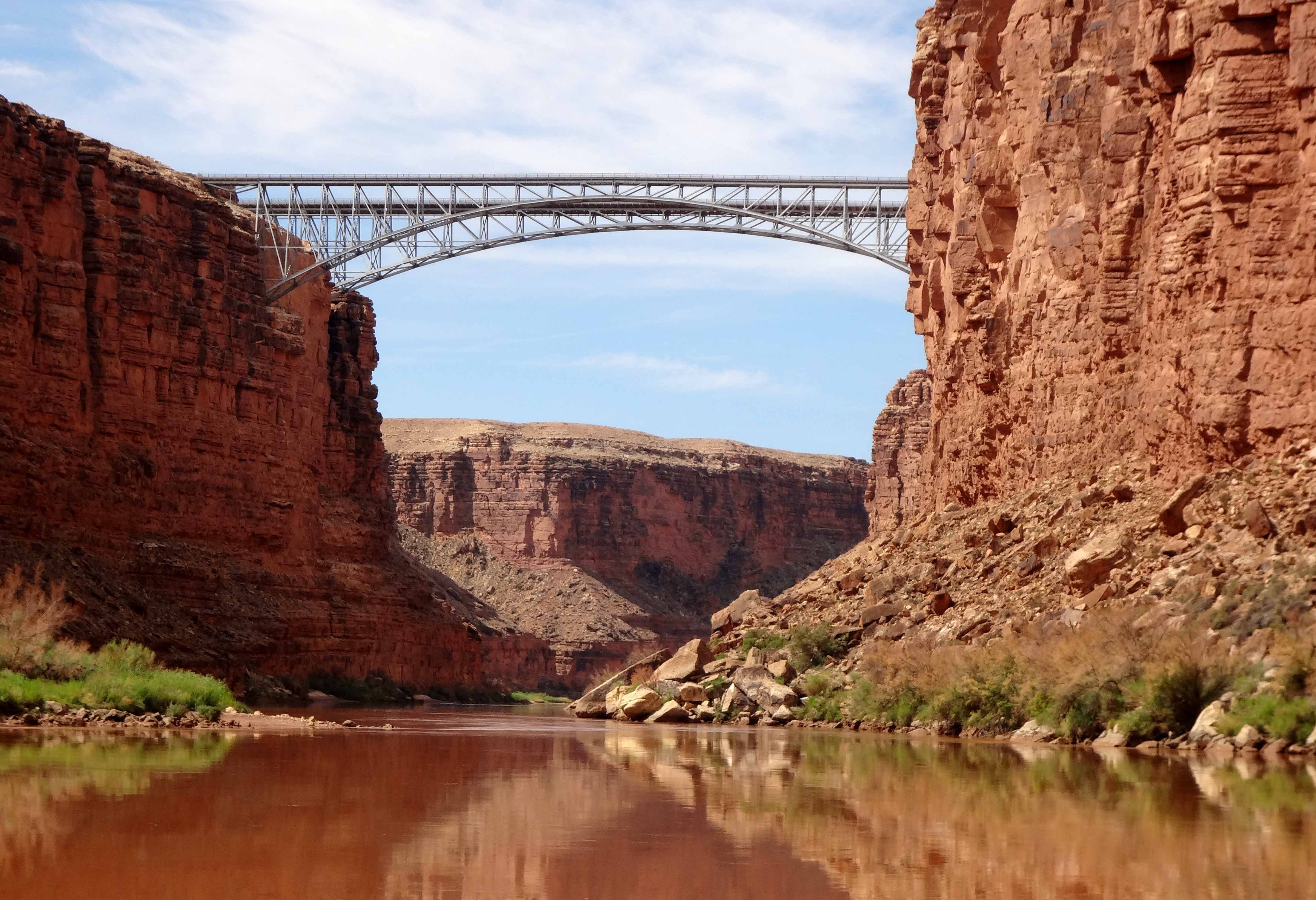
Soon we pushed away from the beach and were inexorably on our way. No way back and nearly 200 miles before we would leave the river. Almost immediately we were rollicking down our first small riffle and very soon we were drifting under the Navaho Bridges, the last vehicular crossing of the Colorado before the Hoover Dam, 350 miles downstream. The original Navaho Bridge, like the adjacent new one, vaults between vertical sandstone cliffs some 470ft above the river. Built in 1929 it is now confined to pedestrian use, vehicular traffic using the newer 1995 bridge. Relatives waved from above though it was difficult to make out faces at this distance.
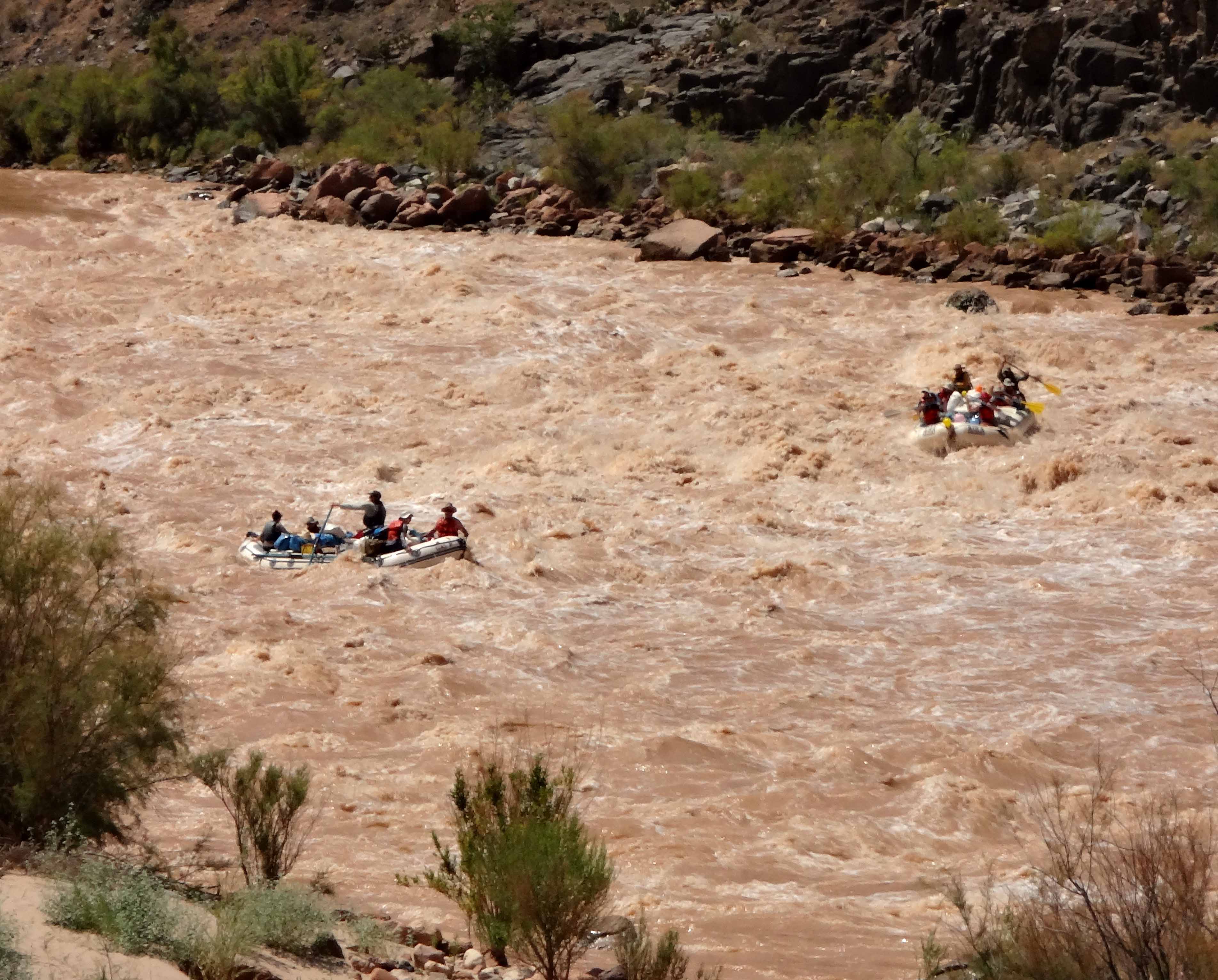
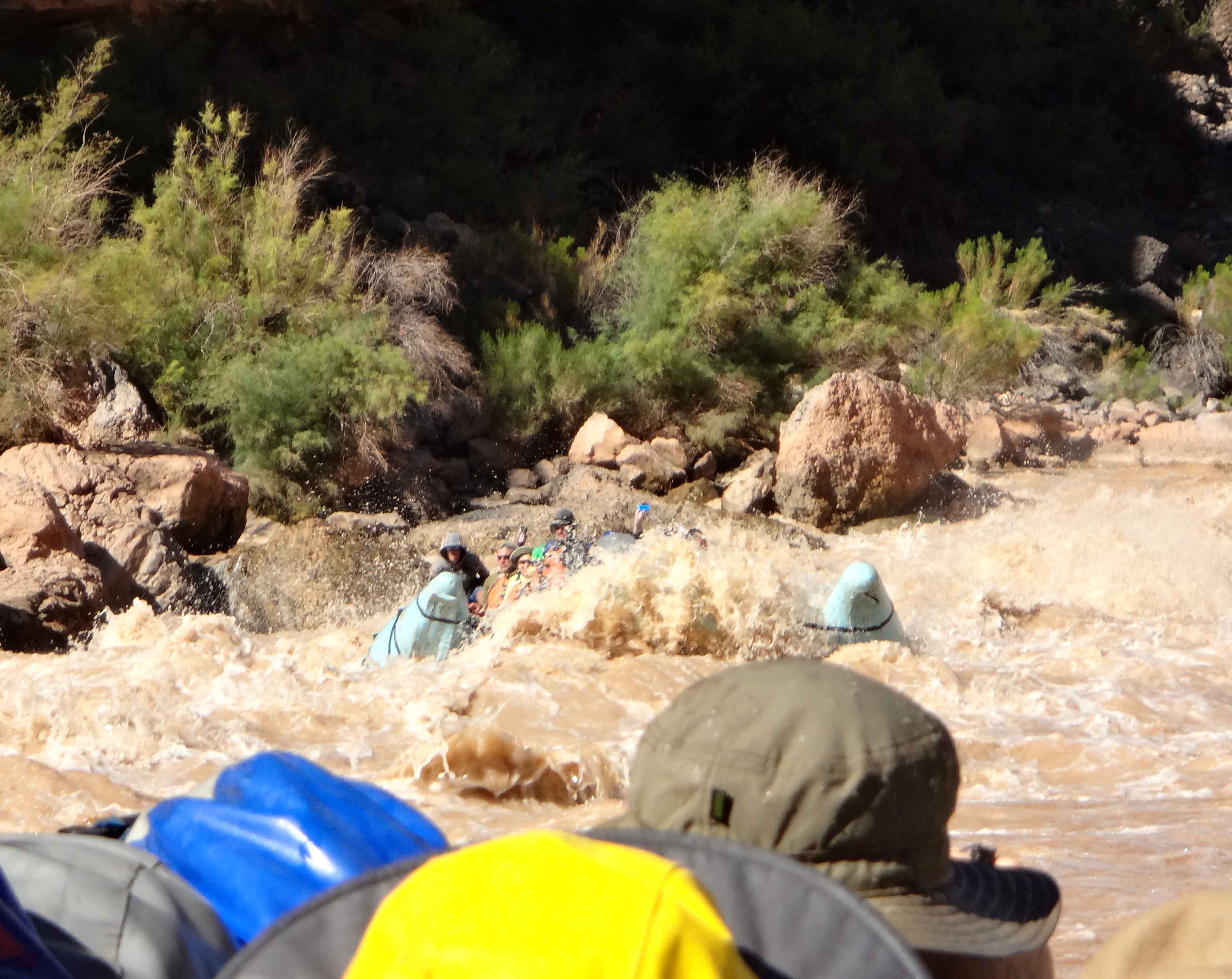
Eight miles from the start we approached the first substantial rapid at Badger Creek and for the first time followed a ritual that would be repeated 100-plus times in the days ahead. We needed to check that our life-jackets were fastened and our day-packs clipped to the boat. Then to sit low along the two sides of the big raft holding onto the secure rope-holds while bracing for the cascades of river water that would envelope us. Since the air temperature during the day exceeded 100 degrees Fahrenheit, these continuous dowsings were quite refreshing but could lead to hypothermia. Hence we carried light, waterproof gear in our day-bags that would keep us dry if we so wished though I never needed mine. The rapids in a big river like the Colorado were mostly formed by flash floods from the tributaries that can deposit a mass of rock in the main river. Over time these masses would be worn down by the main river. Though this erosion generally took many years, each of the rapids could vary substantially from year to year, even from month to month. Consequently, the river-runners knowledge of the rapids needed to be continuously upgraded and a constant "chatter" between the boatmen passed that intelligence up and down the river. Indeed, the smaller, oar-guided expeditions would land upstream to scout out the best route through each of the big rapids. The larger and more robust motorized rafts did not need to exercise such caution but were still susceptible to unexpected obstacles and unplanned difficulties. Even they could get hung up on a large rock or even capsize. Therefore we were not strapped in order to avoid being trapped in or under the raft; in the event of such an unexpected accident it was better for each passenger to float freely and independently down the rapid.
 | 
| |
|---|---|---|
| Badger Creek Rapids | Supai Gorge |
Despite their variability, the larger rapids are graded and documented in several ways. First, like other features such as campsites, trailheads and scenic highlights, they are located and even named by their distance downstream from Lees Ferry. Thus Badger Rapid was at Mile 8.0. Second their size is measured in terms of the elevation drop from beginning to end; Badger is a 15ft drop. Third, they are rated on a less objective scale of ferocity that seems to range up to a value of 10 and varies with the river flow rate; higher flow rates make some rapids more difficult and other rapids easier. In this regard, Badger Rapid is rated as a 4-6.
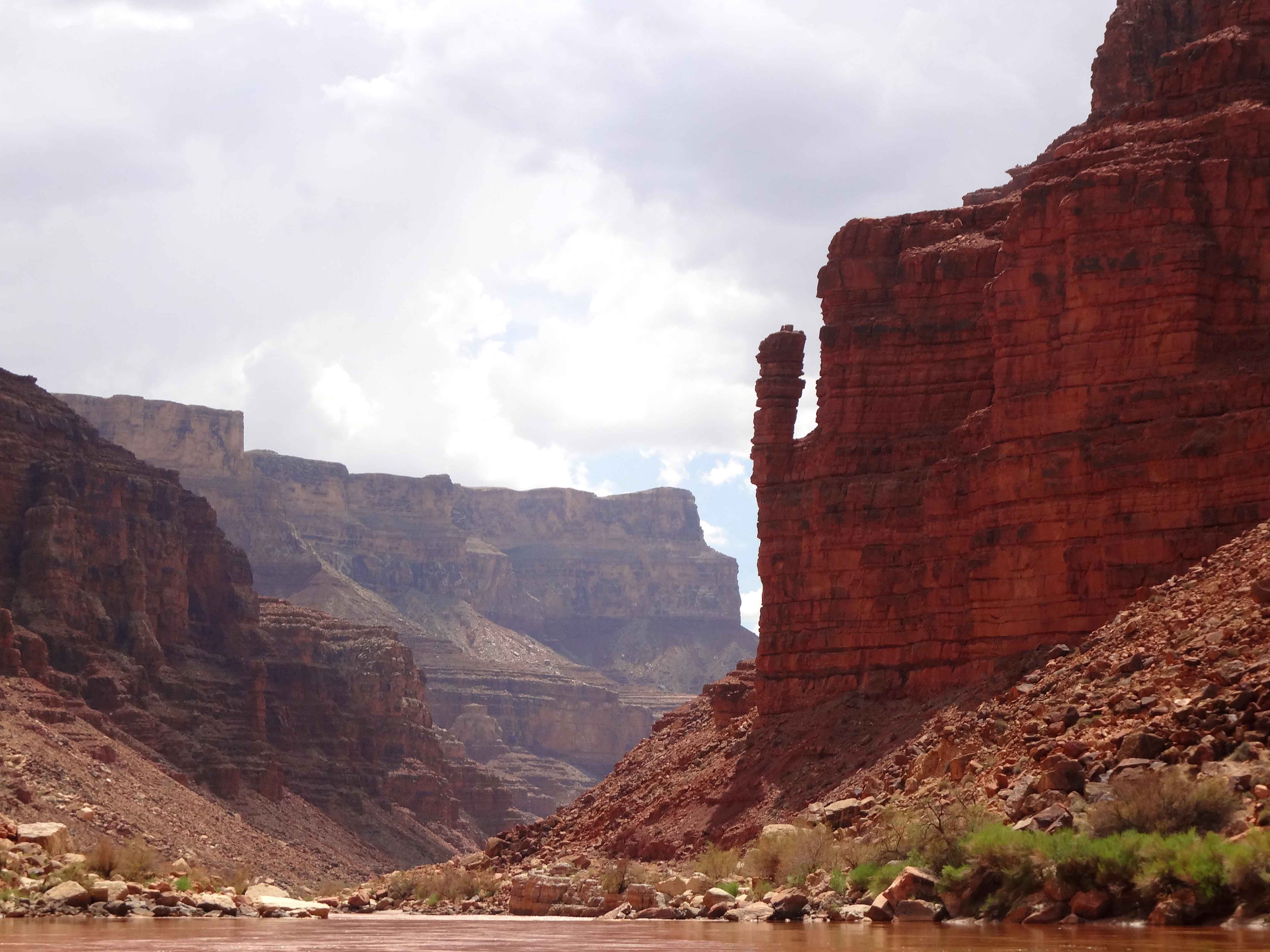
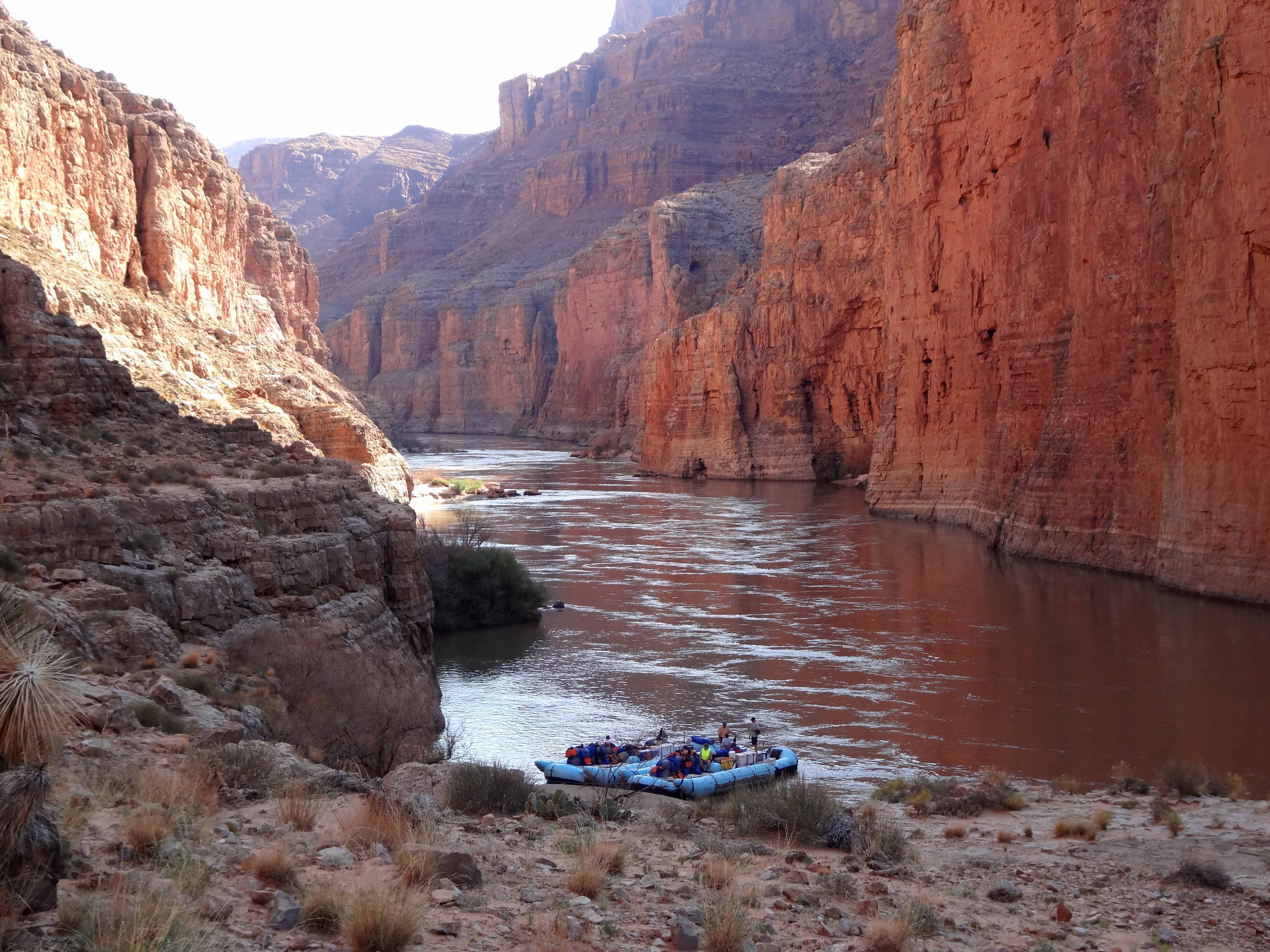
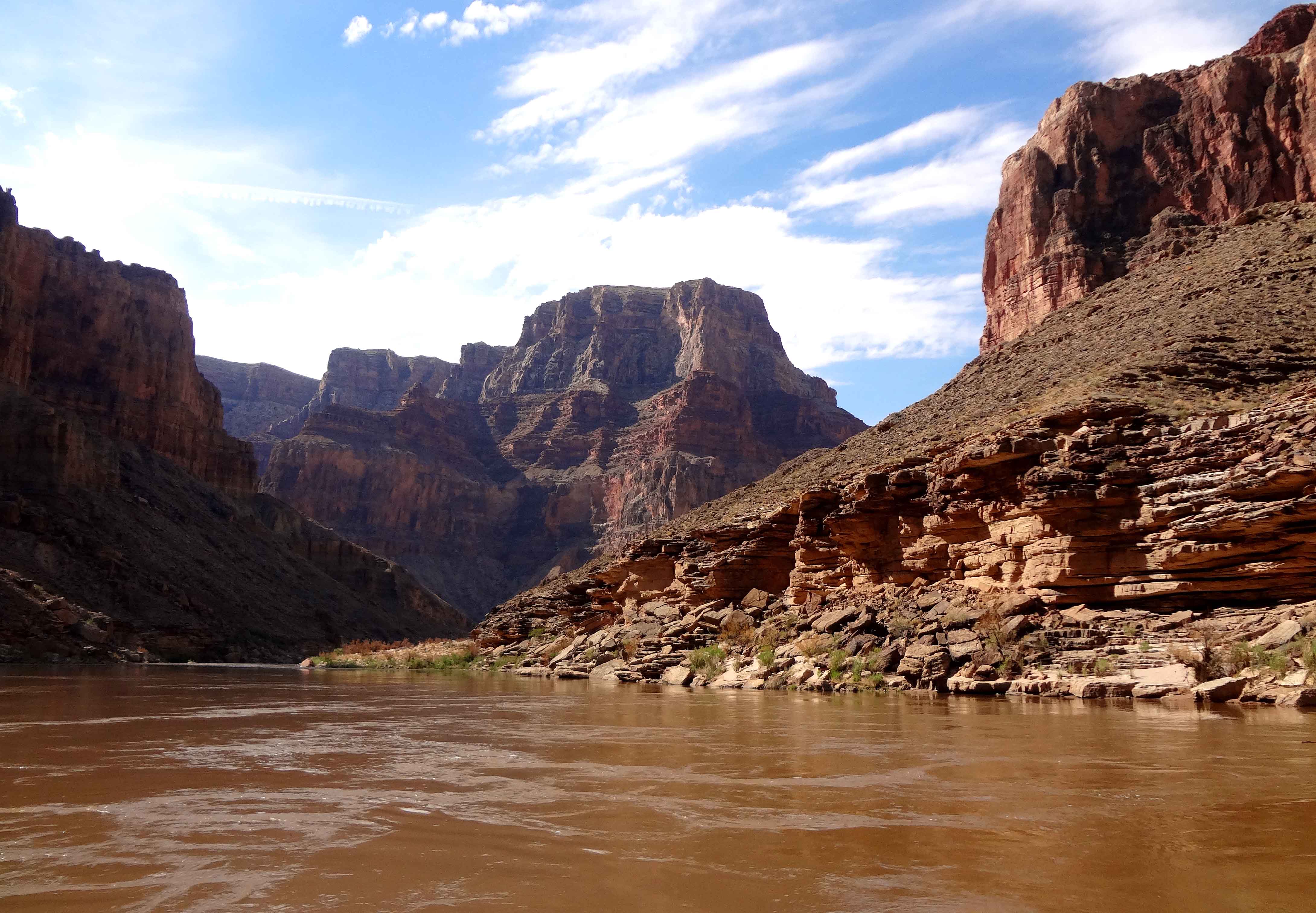
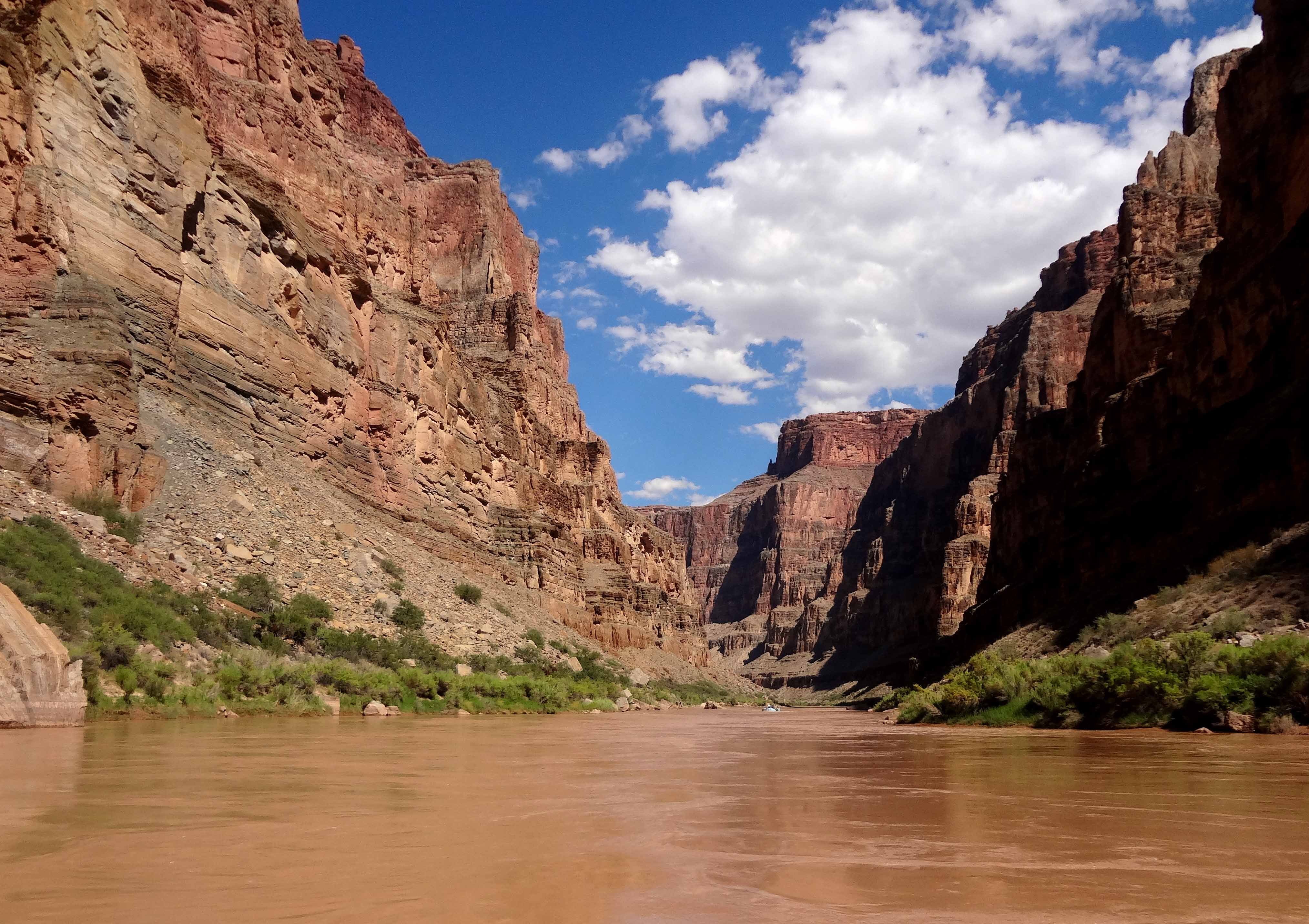
After lunch on the beach at Jackass Camp (Mile 8.1) just below Badger Rapid we began a long stretch of whitewater, Soap Creek Rapid (Mile 11.4, 16ft drop, rating 5-6), Sheer Wall Rapid (Mile 14.5, 9ft drop, rating 2-3), House Rock Rapid (Mile 17.1, 9ft drop, rating 4-7), North Canyon Rapid (Mile 20.7, 12ft drop, rating 4-5) and 21 Mile Rapid (12ft drop, rating 4-5). Just downstream a rock pinnacle on the right is known as "Indian Dick". The rapids continued with 23 Mile Rapid (5ft drop, rating 2-4), 23.5 Mile Rapid (4ft drop, rating 3), Georgie Rapid (4ft drop, rating 3-7), 24.5 Mile Rapid (8ft drop, rating 5-6), and 25 Mile Rapid (7ft drop, rating 5). These last two have seen some tragedies. In 1949, in his final voyage, the legendary Bert Loper died while running 24.5 Mile Rapid. His wrecked boat was found in an eddy a few miles downriver. Bert Loper was 79 years old at the time of his death. In 1889, during the first survey of the river led by Robert Stanton, Henry Richards and Peter Hansbrough flipped their wooden boat in 25 Mile Rapid and were drowned. We made another three descents before our day was done, Cave Spring Rapid (5ft drop, rating 5), 27 Mile Rapid (7ft drop, rating 5) and 29 Mile Rapid (7ft drop, rating 3); this brought the day's total to 14 major rapids with a total drop of 120ft (not counting the smaller riffles) and 29.5 Miles of the Grand Canyon. Of course, the beautiful quiet stretches of water in between the rapids also deserve mention. This was Marble Canyon which Powell described as "... of many colors - white, gray, pink and purple, with saffron tints. It is with very great labor that we make progress, meeting many obstructions... ". There are many stretches with no shore, just great vertical walls on both sides of the river. We camped for the night at such a place, Shinumo Wash Camp at Mile 29.5 at a short stretch of beach below a huge vertical cliff. We ate the first of the excellent meals prepared by the crew and set up our beds for the night in sandy spots of our own choosing. The combined effects of the heat, the excitement of all those rapids and the extraordinary setting made it difficult to sleep until the cool of the night settled in.
 | 
| |
|---|---|---|
| Indian Dick | At South Canyon stop |
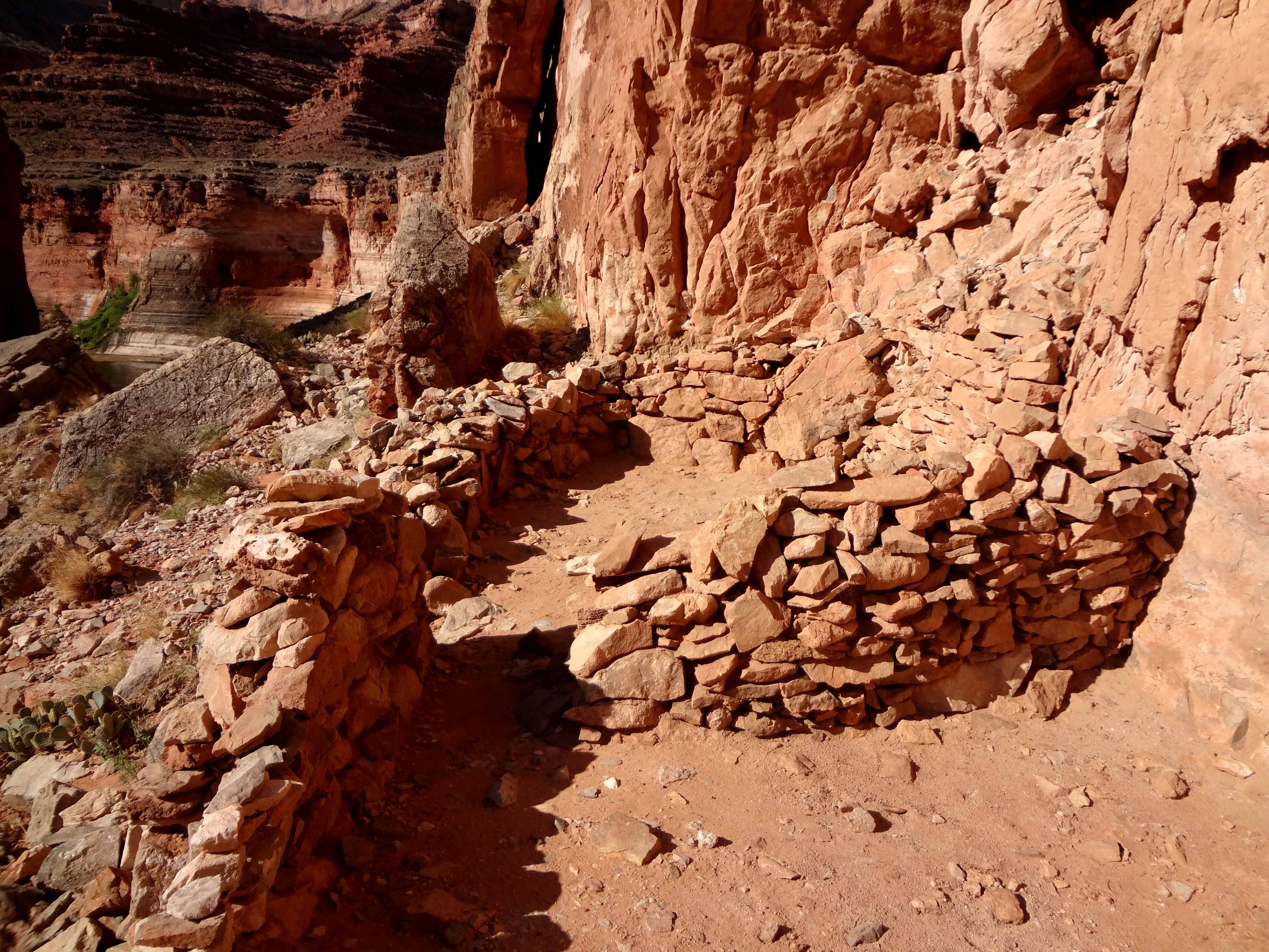
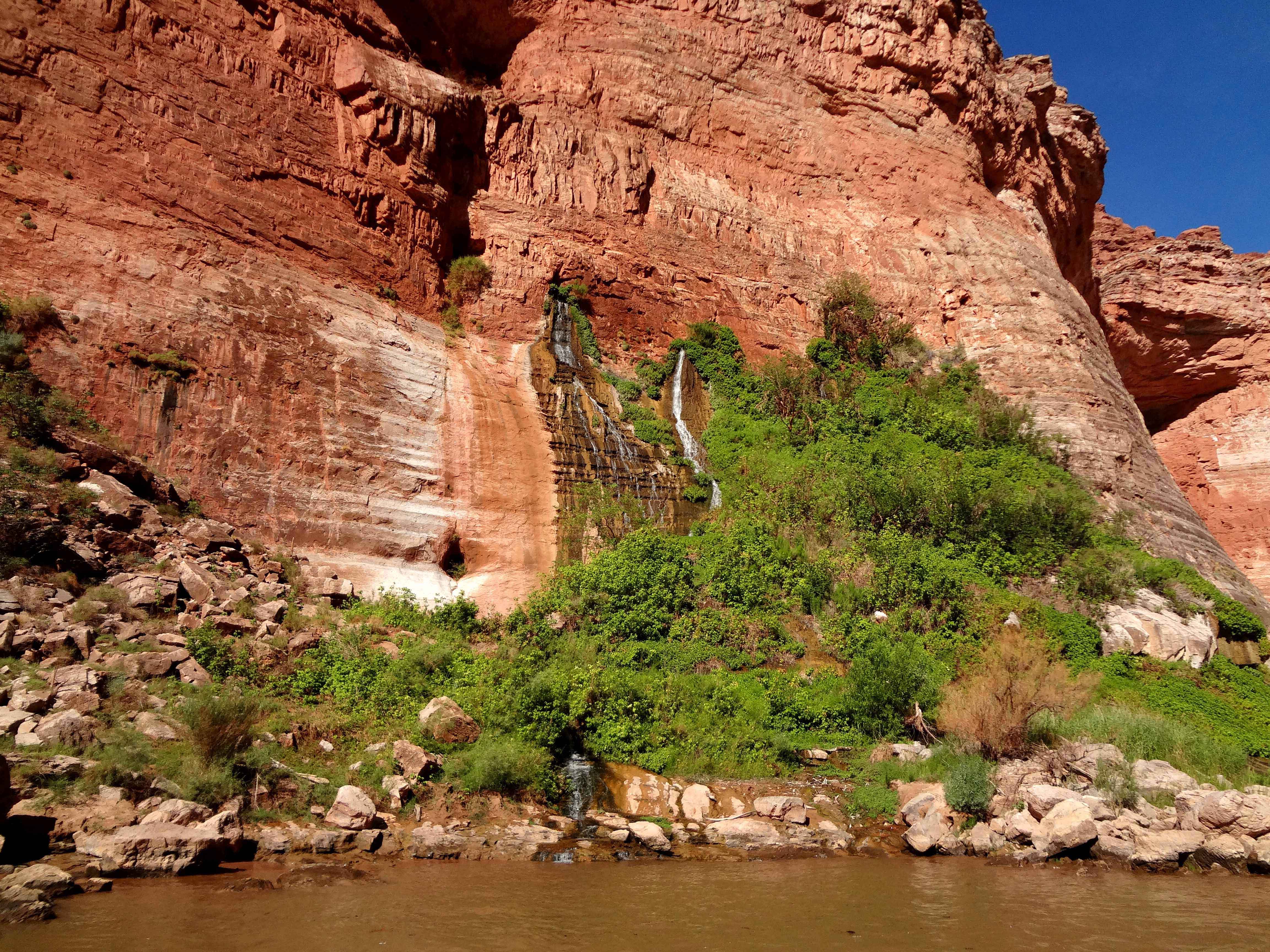
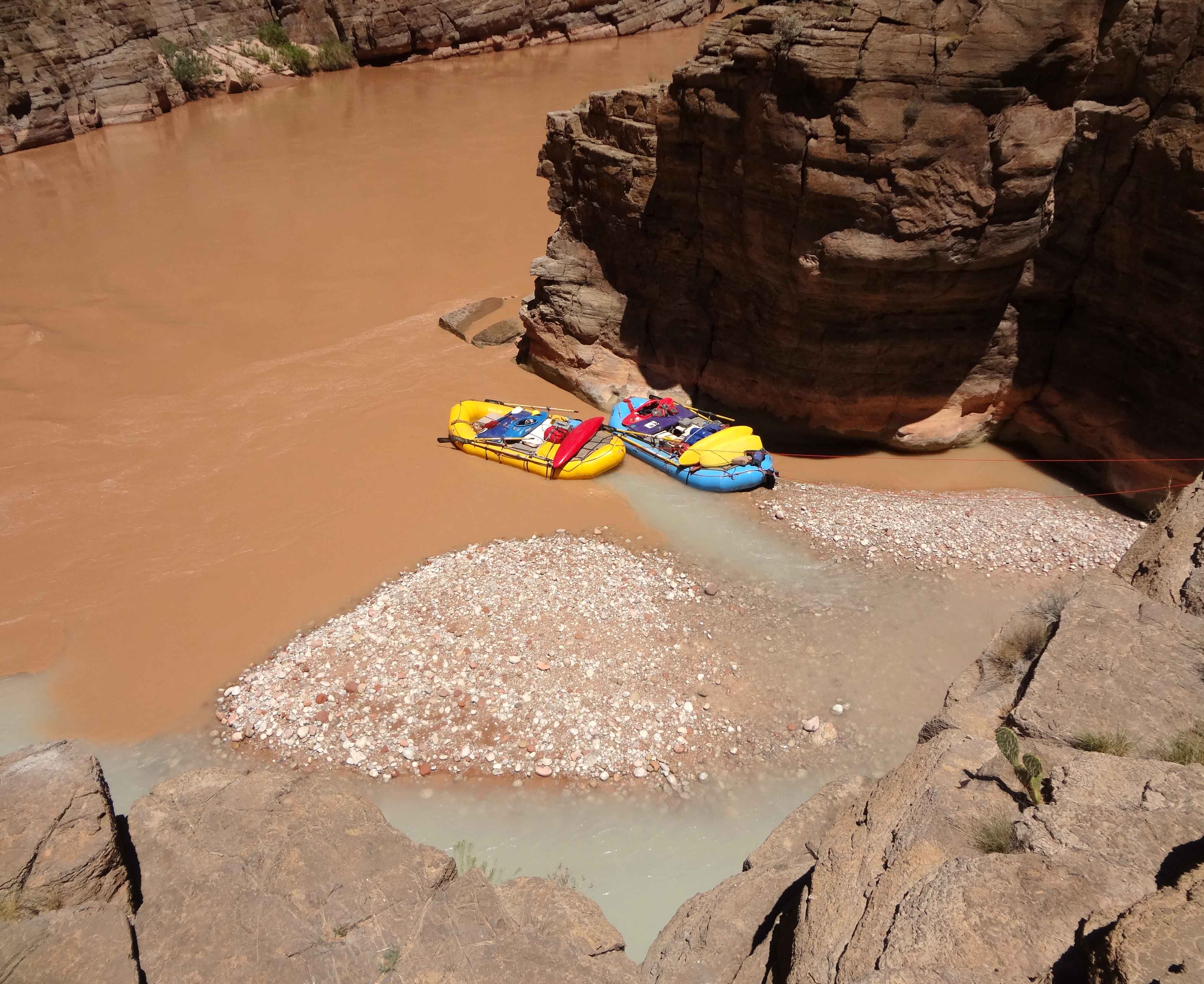
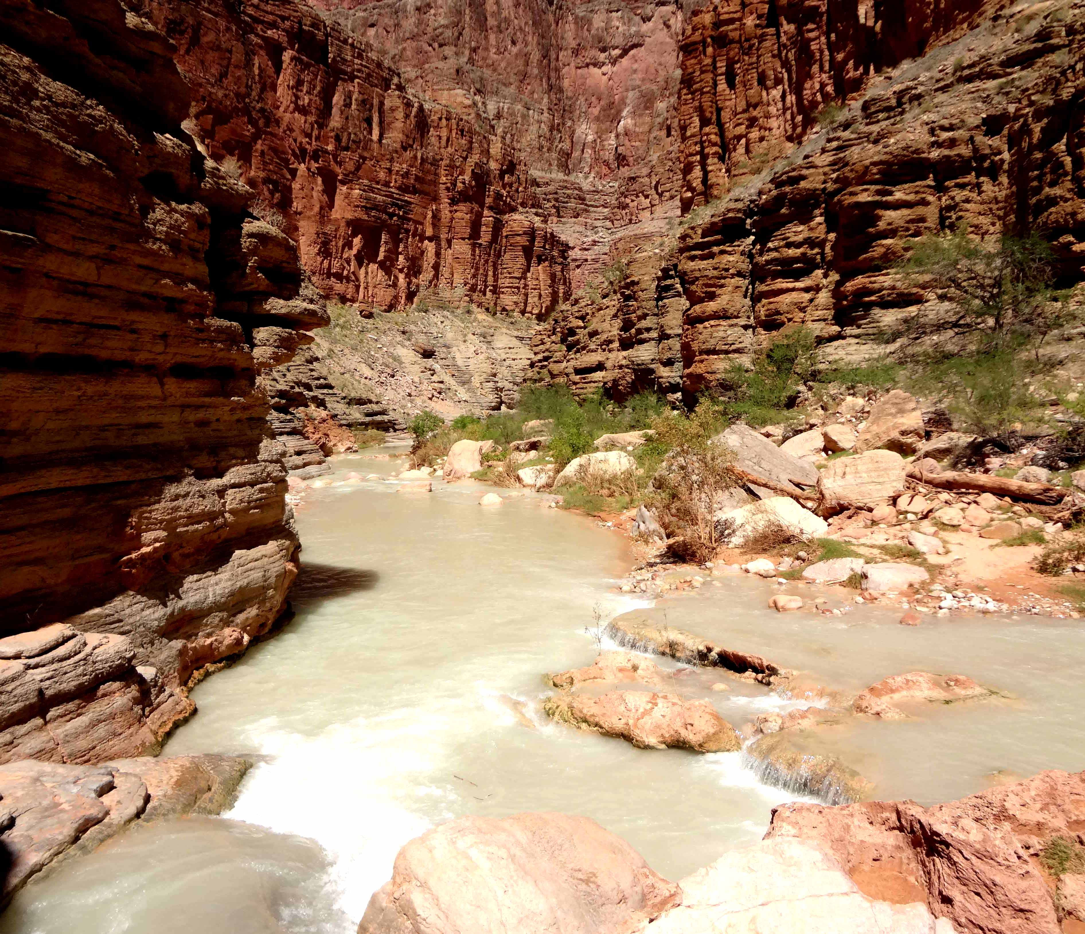
We awoke just before dawn and washed in the cold river; despite the substantial sediment load that caused the Colorado to run red for most of our trip (due to rains upstream in the days preceding our trip) the river is very clean biologically and posed no health hazard. After a cooked breakfast we loaded up early and were on the river by 7.45am. The morning was quiet and free of major rapids. We made stops at several notable features. First at South Canyon (Mile 31.8) we hiked up to ancient Native American ruins about 70ft above the river on the right. Native American people have lived in the Grand Canyon for at least 5000 years and a number of cultures have come and gone during that time. Evidence of their sometimes seasonal occupation can be found at a number of riverside sites within the Canyon, usually at the foot of side canyons, such as South Canyon, that allow access to the Colorado. These South Canyon pueblo ruins and the granary in a cave above them are of fairly recent vintage. However, just a few hundred yards downstream on the north side and 150ft up is Stanton's cave where ancient split-twig figurines of bighorn sheep were found, important artifacts from a hunting culture thousands of years old. Just beyond Stanton's Cave, a beautiful and bountiful spring gushes from the canyon wall about 100ft above the river and cascades down the Redwall limestone, nourishing a vibrant green garden known as Vasey's Paradise (Mile 32.2).
 | 
| |
|---|---|---|
| Anasazi ruin at South Canyon | Vasey's Paradise |
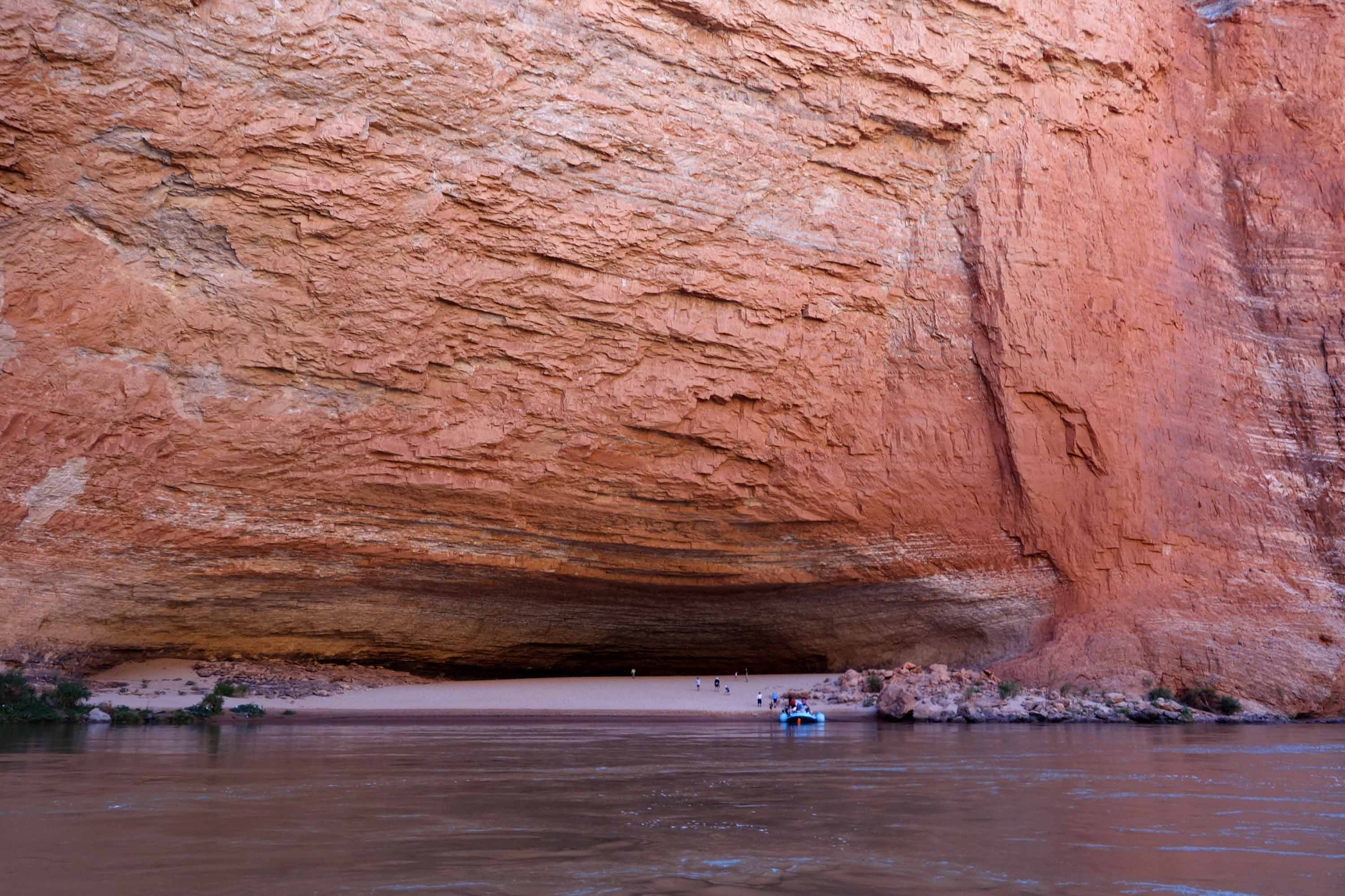
Just a mile beyond Vasey's Paradise is the location of a proposed dam that was, thankfully, never built for it would have flooded the canyon all the way back to Lee's Ferry. Evidence of the exploratory tunnels drilled into the rock can be seen on both sides of the river. Just beyond on the left is the gigantic cave known as the Redwall Cavern where we stopped to explore this remarkable natural feature and to play on its sandy floor. The lunch stop at Nautiloid Canyon was just a short distance downstream. A full afternoon followed beginning with 36 Mile Rapid (4ft drop, rating 4) and a brief halt to hike into the hugely overhung Redbud Alcove (Mile 39.3). The next whitewater, President Harding Rapid (Mile 44.0, 4ft drop, rating 4), ends in a large and notorious eddy on the left that collects lots of debris. In 1890, a year after he drowned in 25 Mile Rapid (some 19 miles upstream) Peter Hansbrough's skeleton was discovered here and buried. The ridge to the north is named after him. Another grave at the big eddy contains the body of 15 year old David Quigley who, in 1956, drowned over 60 miles upstream in Glen Canyon.
 | 
| |
|---|---|---|
| Redwall Cavern | Nankoweap Granary | |
(Photos by Jorge Tung) | ||
 | 
| |
|---|---|---|
| Approaching Unkar delta | Unkar delta from North Rim |
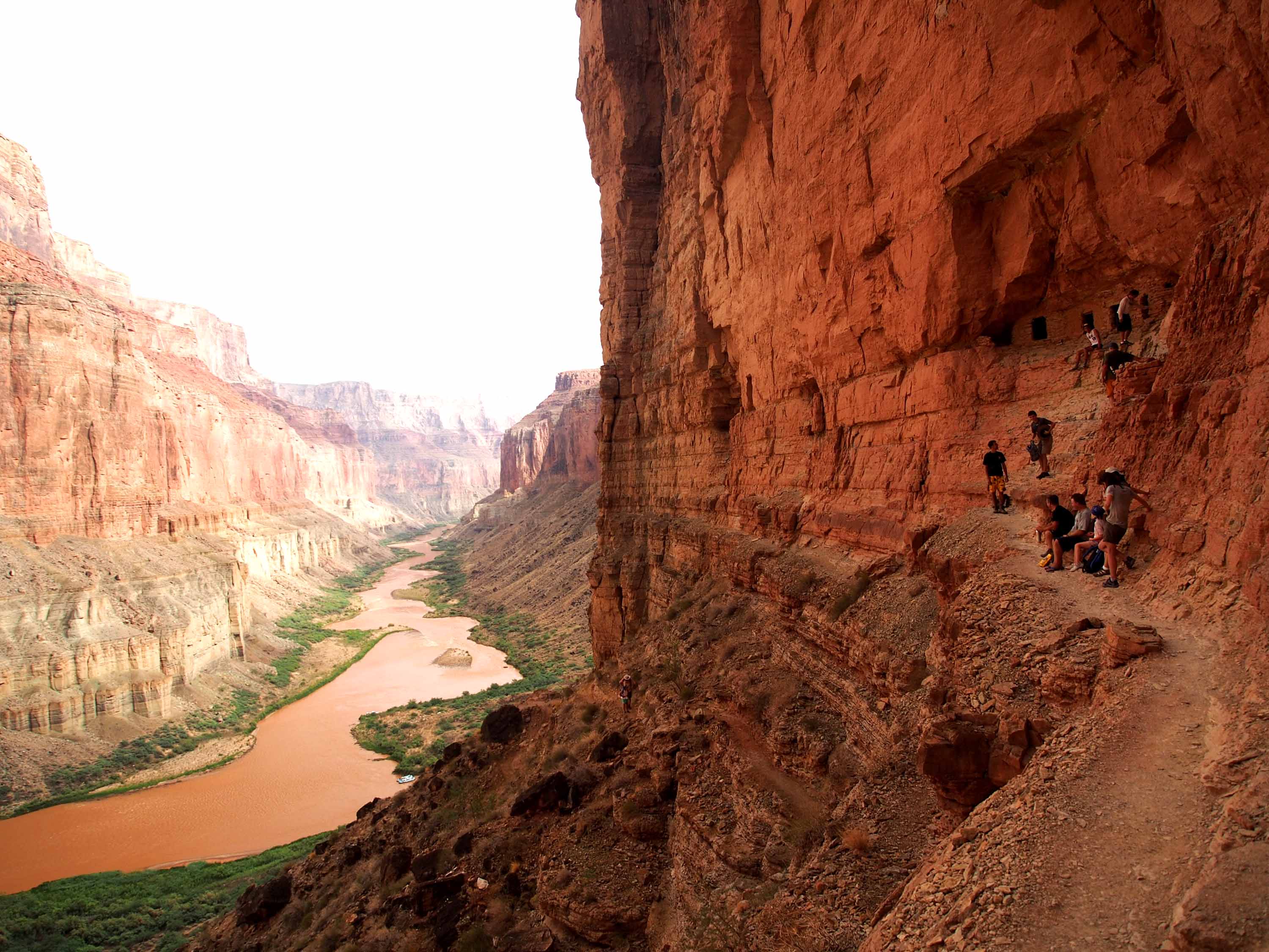
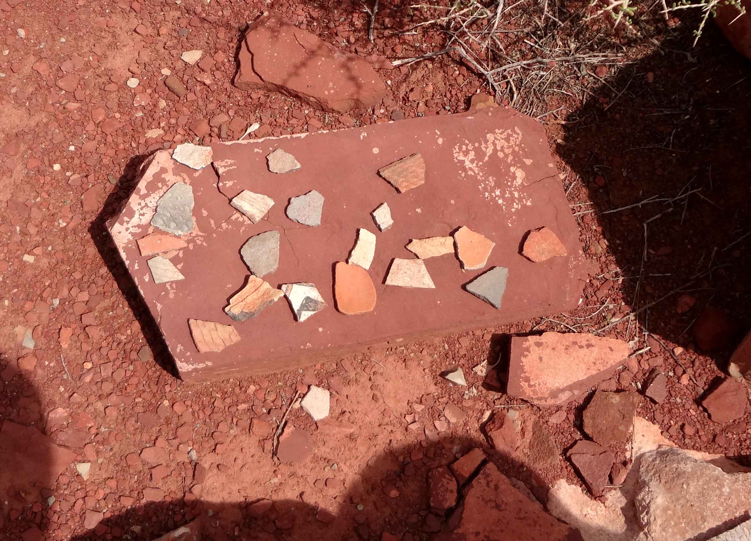
Day 3 dawned bright and clear and we were on our way by 8.10am, descending Kwagunt Rapid (Mile 56.3, 7ft drop, rating 4-6) and 60 Mile Rapid (3ft drop, rating 4) before coming to the confluence with the Little Colorado River that enters from the left at Mile 61.7. In 1956 two airliners bound from LAX to the east coast collided in midair over the Canyon. Their remains are scattered in the area below the confluence. Crash Canyon at Mile 63 was named for this tragedy that took 128 lives. Lava Canyon or Chuar Rapid (Mile 66, 4ft drop, rating 2-4), not to be confused with Lava Falls far downstream, was next and here you encounter one of the less-commonly travelled trails that descend from the South Rim, namely the Tanner Trail that reaches the river at Mile 69 where Tanner Rapid (20ft drop, rating 2-4) is also located. Just a short way downstream comes the wide sweeping bend around the delta formed by the incoming waters of Unkar Creek. Here, at Mile 72.7, there are many Native American remains including those of extensive Cohoninan and Puebloan dwellings dating from the period AD 950-1150. The residents would typically spend the winter months in the canyon where they grew corn, beans and other crops. In the summer they would migrate up to the Rim to hunt and forage. Presumably the ease of the trails leading up and down from both the North and South Rims made the Unkar Delta a center of Pueblo Indian activity before the canyon was essentially evacuated in the mid-twelfth century. In the days preceding our voyage I had viewed the Unkar Delta from the North Rim; even with my binoculars I could not really make out any boats that might have been passing it. Now we stopped for a walk across the low-lying ground of the delta; shards of ancient pottery lay everywhere and presumably had lain there for at least 700 years.
 | 
| |
|---|---|---|
| Pottery shards at Unkar delta | Boat Beach, Phantom Ranch |
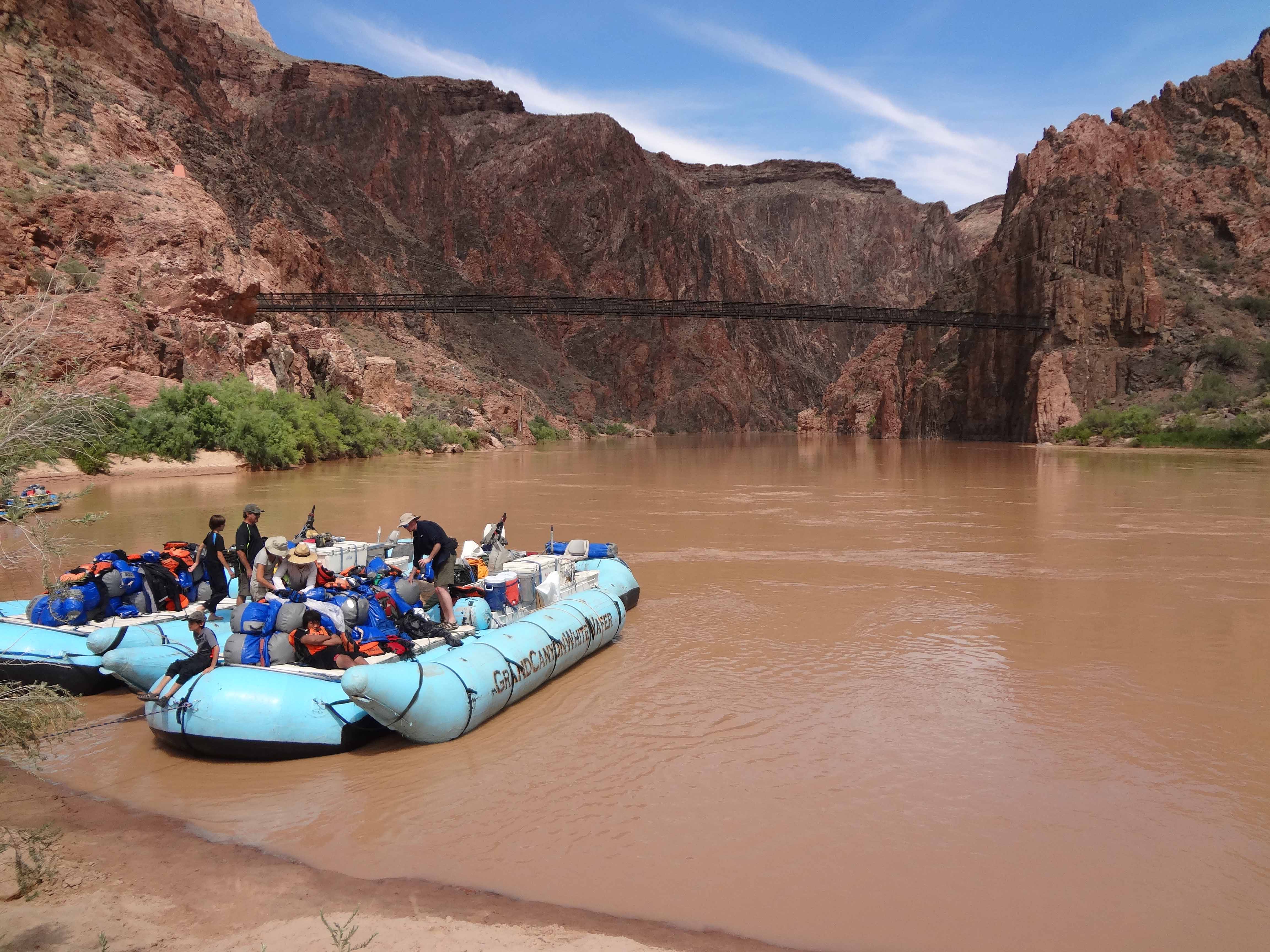
Taking our places in the boats once again we prepared for a vigorous series of rapids. Unkar Rapid (Mile 72.9, 25ft drop, rating 4-7) and then Nevills Rapid (Mile 75.8, 16ft drop, rating 4-7, named for the pioneer of commercial river trips, Norman Nevills) were like appetizers leading to two big ones. At Mile 77.2, Hance Rapid (30ft drop, rating 7-8) is one of the most feared in the canyon. "Captain" John Hance, a miner and rancher, was the South Rim's first white settler and the Hance Trail which meets the river here is one of the more popular trails descending from the South Rim. The rapids named after Hance were considered the start of what Powell called "The Granite Gorge". Not far downstream at Mile 79.1 is another big one, Sockdolager Rapid (19ft drop, rating 5-7) with a large hole and lateral wave at the top right and large hydraulics further down. It was time for lunch and we stopped just downstream of Sockdolager Rapid on the left bank. Reinvigorated we resumed our river-running with another big one, Grapevine Rapid at Mile 82.1 that drops 17ft with a rating of 6-7. This was followed by two smaller ones, 83mile Rapid (Mile 84.1, 7ft drop, rating 3-6) and Zoraster Rapid (Mile 85.3, 5ft drop, rating 4) before we suddenly encountered "civilization" again in the form of the Kaibab Suspension Bridge.
It seemed strangely discordant to encounter human structures and activity after three days in the wilderness. A mule train was crossing the suspension bridge as we passed under it and tied up at Boat Beach where the heavily used South Kaibab Trail descends from the South Rim Village to meet the river. Here the expedition would replenish its water supply from the nearby spigots fed by the pipeline down from Indian Springs. The group all hiked to the Phantom Ranch half a mile up the Bright Angel Creek or North Kaibab trail to sample the food and drink at the Phantom Ranch Store. This is where most hikers bed down or camp during hikes down from the North or South Rim. The Ranch also serves food to hungry river-runners though almost none of us had thought to secret money in our day-bags and had to borrow from Alex who did have the foresight to do so. Many of us also enjoyed a dip in the lovely Bright Angel Creek, much warmer and more inviting than the chilly Colorado.
The day was dwindling as we returned to the boats and cast off again. After the smaller Pipe Springs Rapid (Mile 89.5, 7ft drop, rating 3) we ended the day's voyage with another big one, the feared Horn Creek Rapid (Mile 90.8, 9ft drop, rating 7-9). Camp for the night was on the left bank at Salt Creek Camp (Mile 93) just upstream of the Salt Creek Rapid. A neat slot canyon penetrated the cliff wall just beside this beach camp.
 | 
| |
|---|---|---|
| Rapids | Desert Bighorn Sheep at mile 103 |
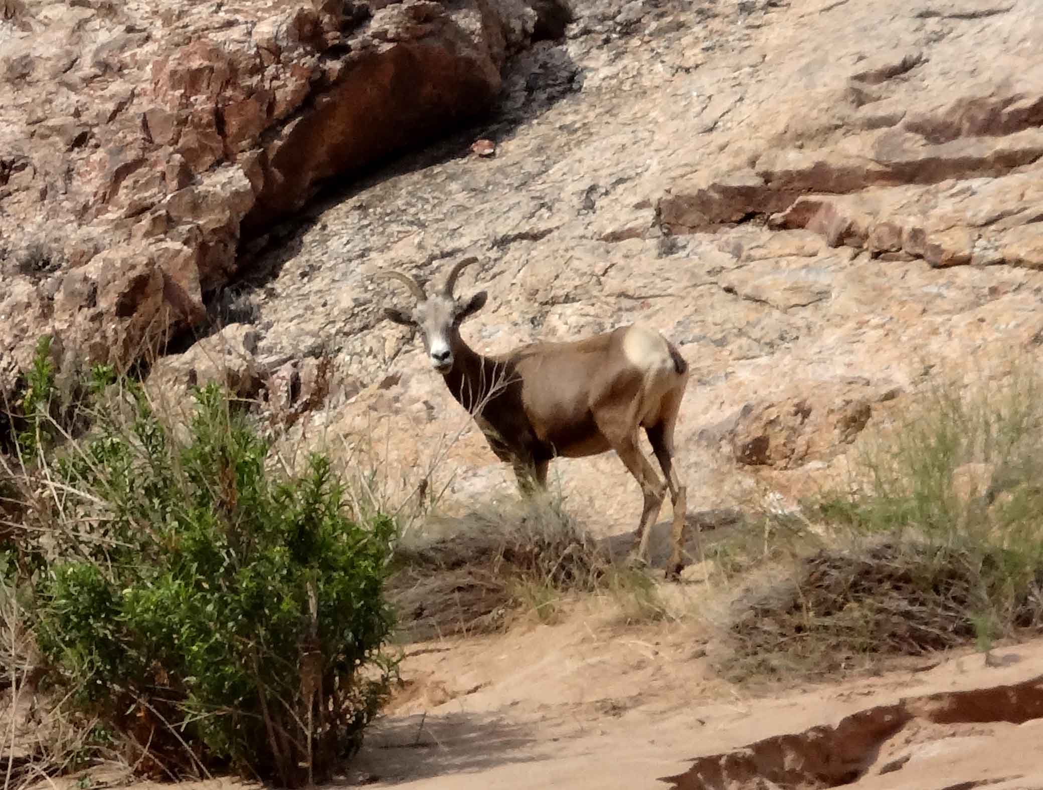
Day 4 began with now familiar routine of breakfast and packing, increased efficiency accounting for an early cast-off at 7.50am. The morning was filled with rapids, beginning with Salt Creek Rapid (Mile 93.1, 5ft drop, rating 2) before tackling the huge lateral waves and nearby right wall of Granite Rapid (Mile 93.9, 18ft drop, rating 7-8) which is visible from the South Rim. This was followed by the biggest roller-coaster in the canyon, Hermit Canyon (Mile 95.5, 15ft drop, rating 7-8) with five big waves at the foot that seemed to stand the boat on its end. The smaller Boucher Rapid (Mile 97.1, 13ft drop, rating 4-5) was then followed by the difficult Crystal Rapid (Mile 98.8, 17ft drop, rating 7-10) which has big holes near the top and a rock garden in midstream at the bottom. The succession of rapids continued with Tuna Creek Rapid (Mile 99.7, 10ft drop, rating 5-7), Lower Tuna (Willie's Necktie) Rapid (Mile 100.0, 10ft drop, rating 4), Sapphire Rapid (Mile 101.8, 8ft drop, rating 6) and Turquoise Rapid (Mile 102.6, 4ft drop, rating 2-4). Just downstream of here we spotted our first bighorn sheep grazing at the water's edge. We would see many more in this and the following days; one could not help but wonder how they negotiate the great cliffs and canyons of this awesome place. Clearly they are drawn down to the foliage growing on the narrow strip along the river bank. This includes tamarisk trees, a non-native species, that spread rapidly into the riverways of the west in the 1930s after it was imported from Asia. However, in 2004, after decades of research, tamarisk leaf beetles were released in Moab in order to control the tamarisk; they spread rapidly down the Colorado and are now killing the tamarisk and allowing native species to re-establish themselves.
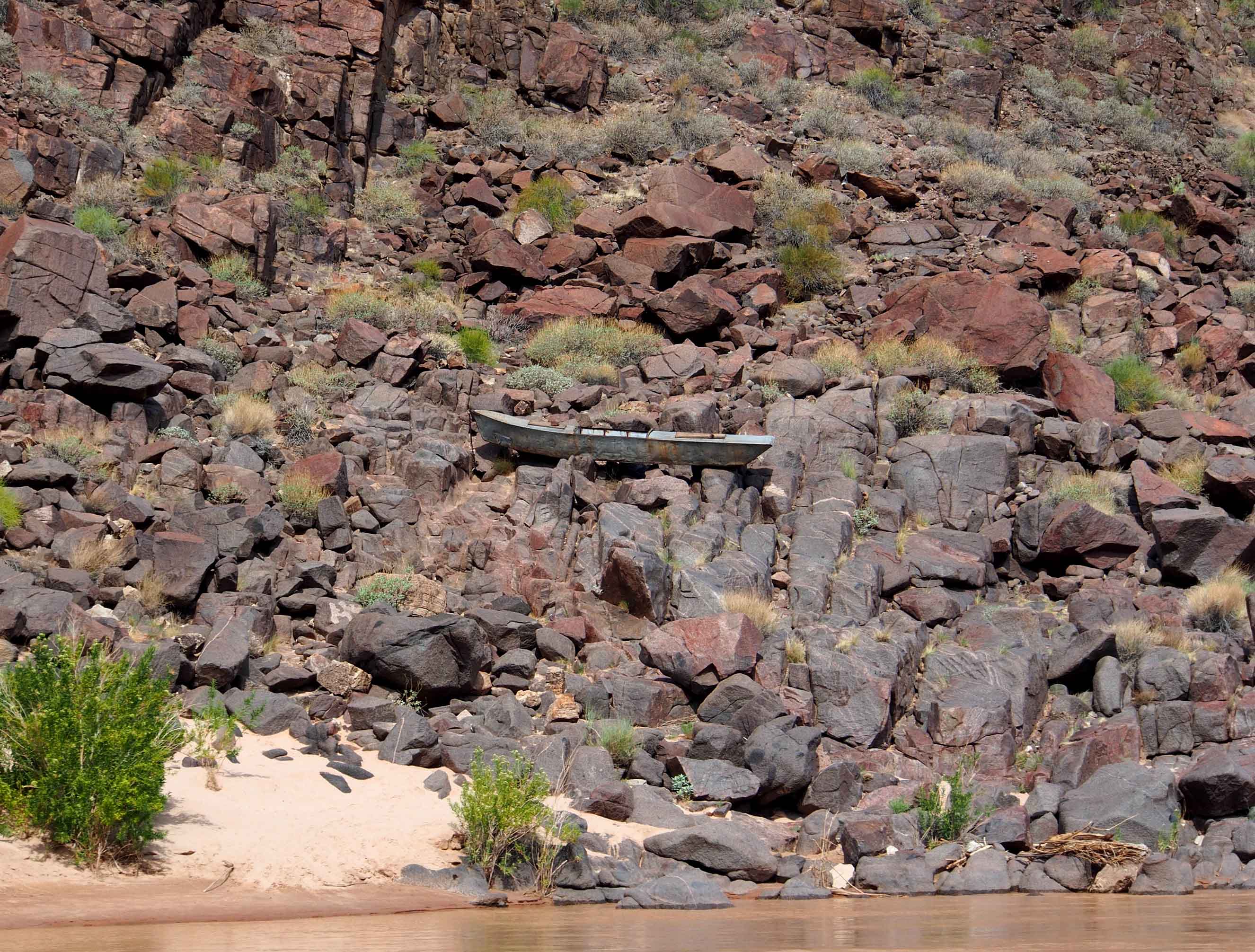
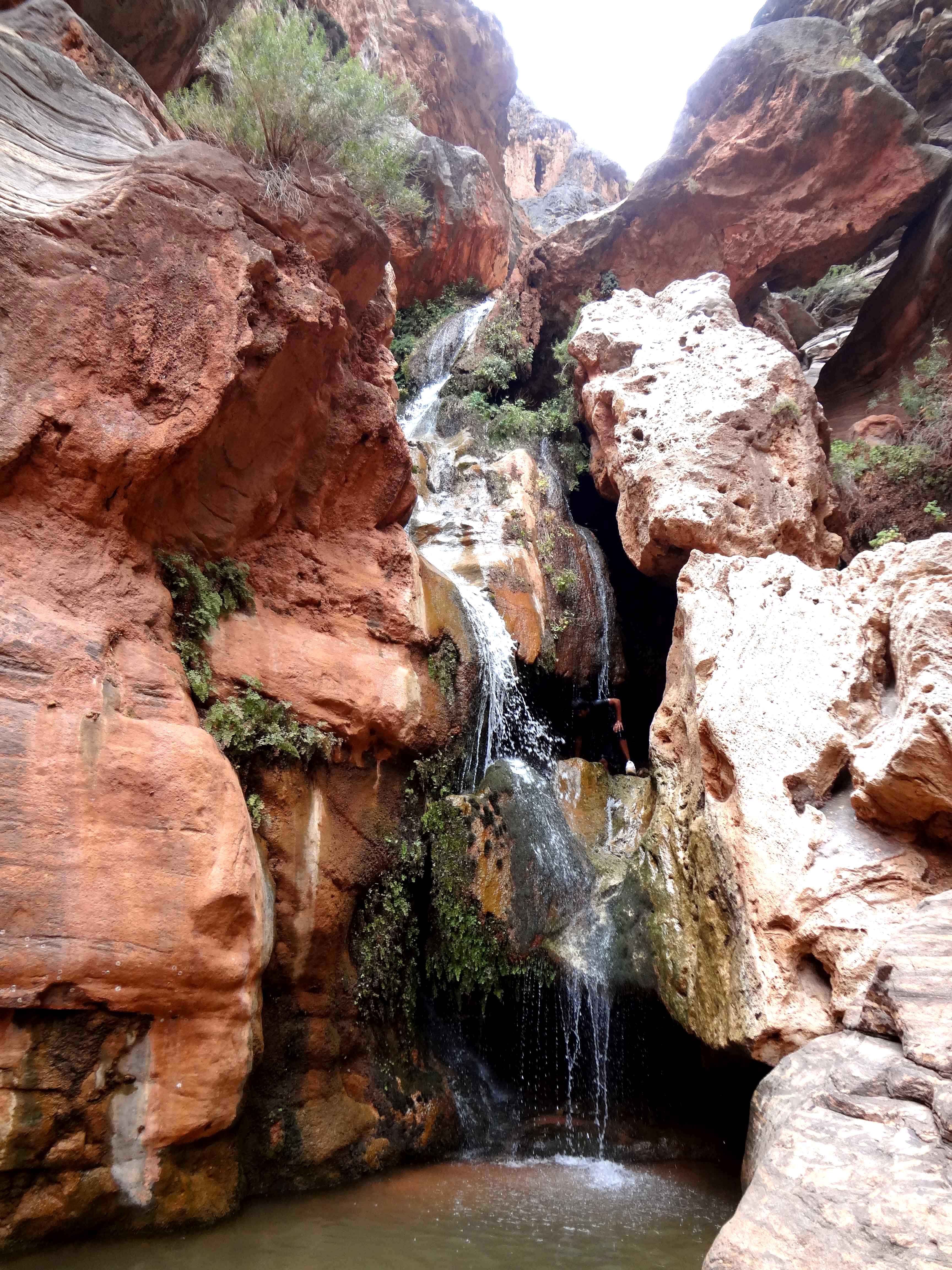
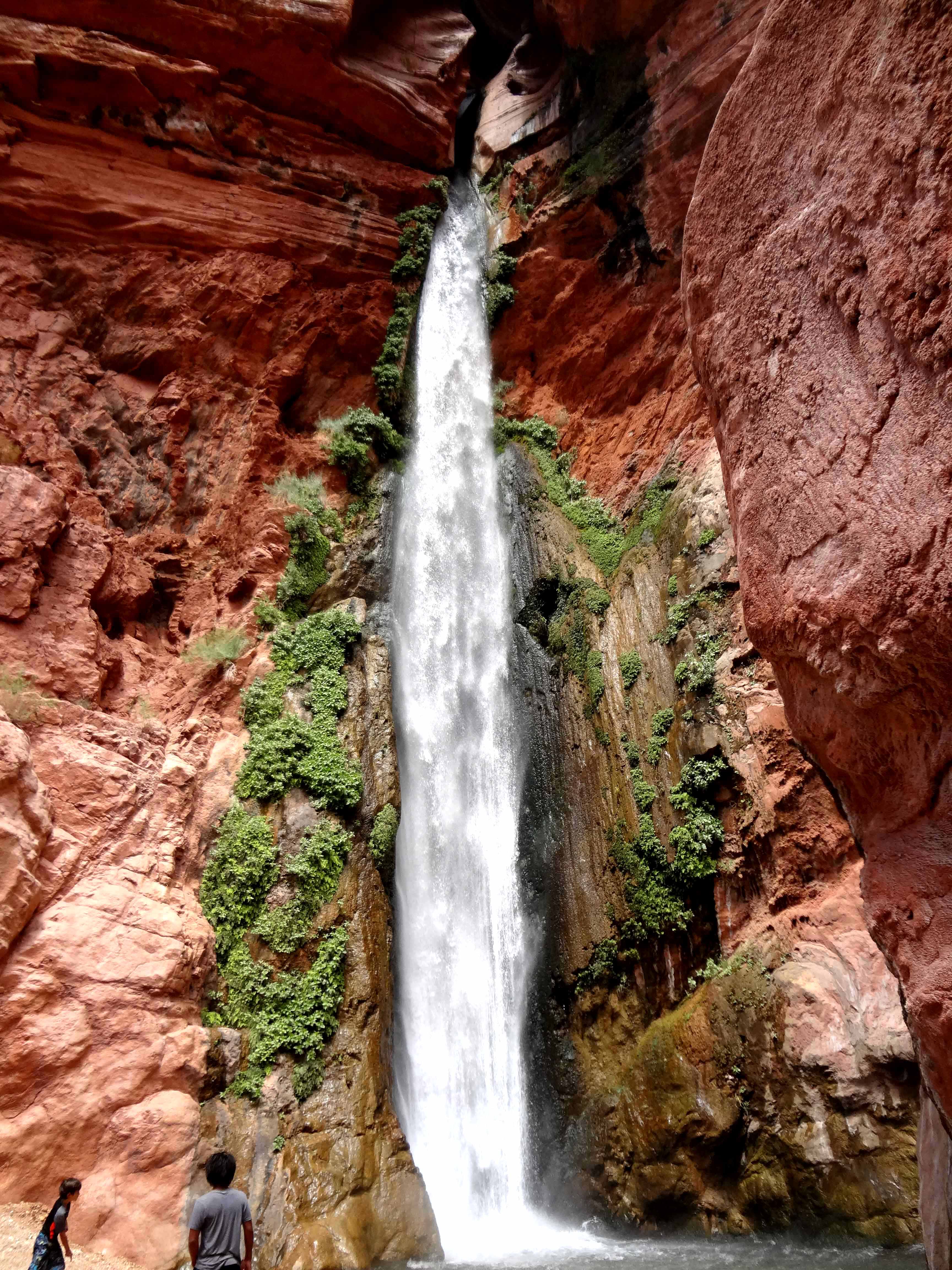
The precious stone series of rapids resumed with Emerald Rapid (Mile 104.5, 4ft drop, rating 5), Ruby Rapid (Mile 105.2, 11ft drop, rating 4-5) and Serpentine Rapid (Mile 106.5, 12ft drop, rating 6) before we came to the junction with another major trail at Mile 108.3. The Bass Trail is named after William Bass who built the trail and a cableway to ferry people across the river. The Ross Wheeler steel boat, designed by Bert Loper in 1914, was abandoned by motion picture man Charles S. Russell in 1915 and remains at the foot of South Bass Trail. Just beyond this is Bass Rapid (Mile 108.4, 5ft drop, rating 3) and Shinumo Rapid (Mile 109.3, 8ft drop, rating 2-3); below the latter we stopped for lunch and and hiked 50yds up Shinumo Creek to a pretty waterfall where many of us cooled off with a natural shower. Three more rapids followed after lunch, namely 110 Mile Rapid (17ft drop, rating 2-3), Hakatai Rapid (Mile 114.4, 8ft drop, rating 2-3) and Waltenberg Rapid (Mile 112.8, 14ft drop, rating 3-5). Then, at Mile 117.2, we stopped and hiked/climbed about 100yds up into a narrow canyon to a magical little waterfall called Elves Chasm. Almost everyone climbed a few feet up behind the falls and jumped back down into the crystal pool at is base. We tarried here for more than an hour before boarding the boats for a short drift down to the overnight camp at Mile 119.8.
 | 
| |
|---|---|---|
| Ross Wheeler Boat at Bass crossing | Elves Chasm |
 | 
| |
|---|---|---|
| Blacktail Canyon | Oar boats in Blacktail Rapids |
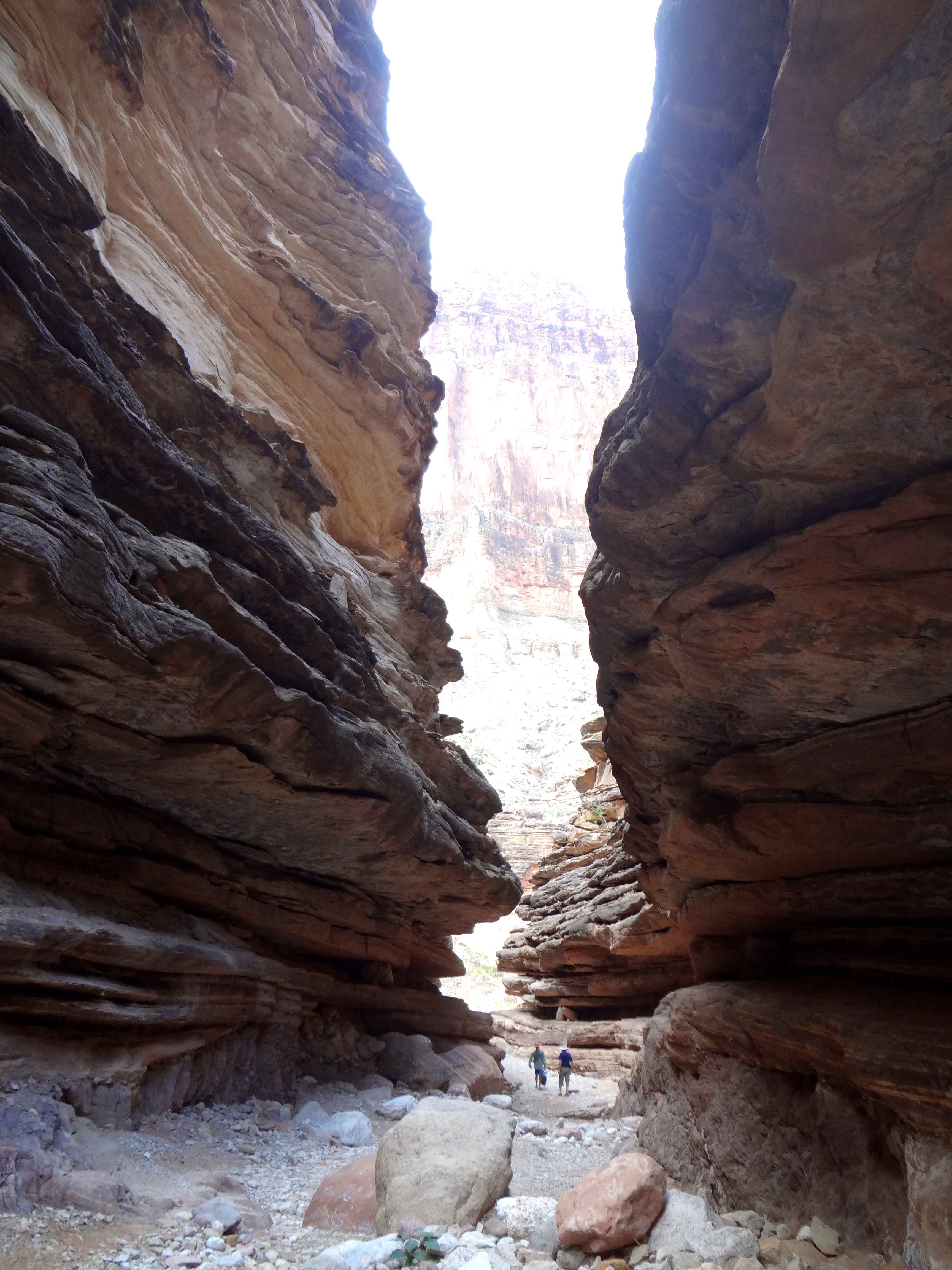
Back afloat five more rapids were encountered in quick succession: Forster Rapid (Mile 123.3, 7ft drop, rating 3-6), Fossil Rapid (Mile 125.5, 15ft drop, rating 3-6), 126 Mile Rapid (8ft drop, rating 4), Specter Rapid (Mile 129.7, 6ft drop, rating 6), and Bedrock Rapid (Mile 131.1, 8ft drop, rating 6-8) in a sharp right hand bend with a large midstream island that we passed on our left. Some boaters have been left stranded on the island. Deubendorff Rapid (Mile 132.2, 15ft drop, rating 5-8) follows almost immediately and is a tricky one with many rocky obstacles. Just downstream we landed at Stone Creek Camp for a hike into that side canyon to another pretty waterfall, followed by lunch.
 | 
| |
|---|---|---|
| Inner Gorge | Deer Creek Falls |
 | 
| |||
|---|---|---|---|---|
| Deer Creek slot canyon | ||||
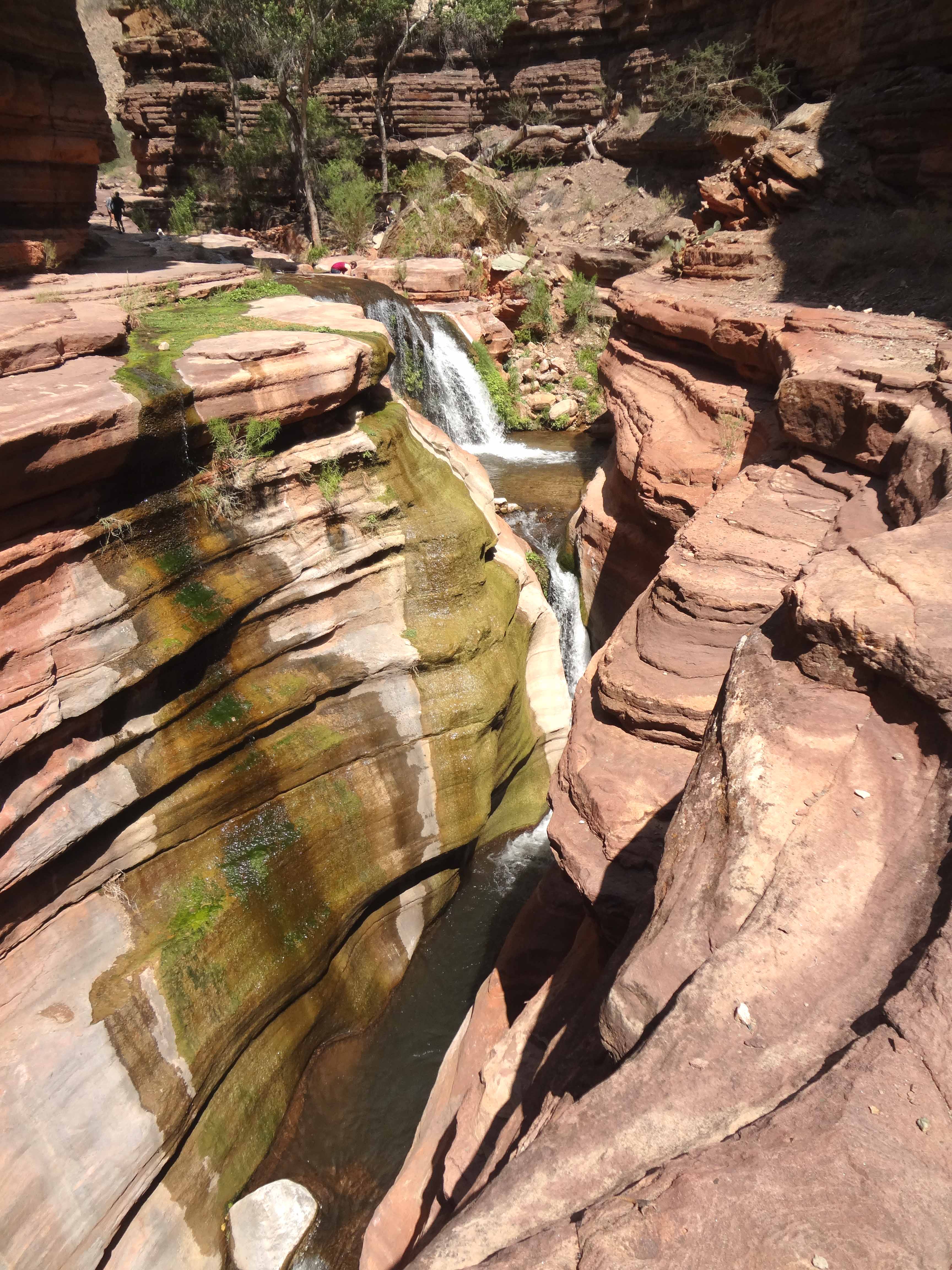
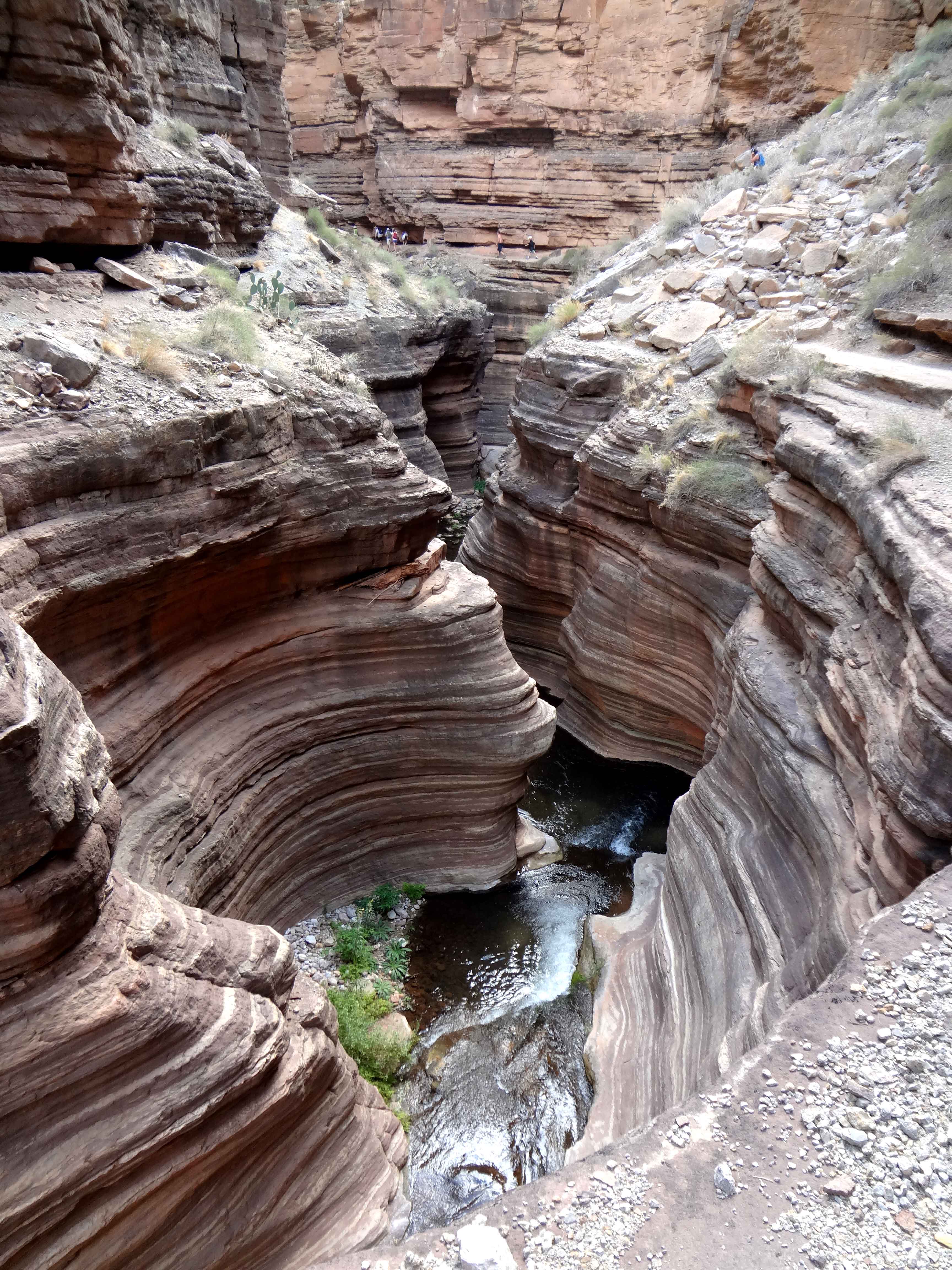
The afternoon began with Tapeats Rapid (Mile 134.3, 15ft drop, rating 4-5) and 135 Mile Rapid (10ft drop, rating 3) before we drew into the rocks off the Deer Creek confluence at Mile 136.9. This was to be the highlight of the day for Deer Creek emerges from a narrow slot high overhead and plunges vertically over 100ft into a pool beside the Colorado River. We first walked a few yards to the pool at the base of the falls and waded in to experience the violence of the substantial flow of falling water. Then we followed the trail that switchbacks up the steep rockface to the left of the falls for about 200ft before contouring into the slot canyon along one of the ledges that characterize the Tapeats Formation. The precipitous trail then continues into the slot along that ledge for several hundred yards, narrowing to a nerve-wracking couple of feet in places. It is a spectacular adventure high above the stream that crashes through the slot over 50ft below the trail. Eventually, deep into the Tapeats Formation, the stream comes up to meet the trail ledge at a place known as the Deer Creek Patio. We hiked a little further upstream in Deer Creek itself, enjoying the pools and falls of the Patio and relishing the experience of this lovely place. It was almost 2.5 hours after we landed that we reluctantly took to the river again for a short voyage down to our overnight camp at the Football Field on the left bank at Mile 137.5.
 | 
| |
|---|---|---|
| Junction with Havasu Canyon | Havasu Creek |
After an 8am start, day six began with another smorgasbord of rapids, beginning with Doris Rapid (Mile 138.4, 5ft drop, rating 4), Fishtail Rapid (Mile 139.7, 10ft drop, rating 4) and Kanab Rapid (Mile 144.0, 12ft drop, rating 2-5), this last at the large confluence where Kanab Canyon and its trail come in from the north. It was here that John Wesley Powell ended his second canyon trip and hiked out to the north. This was followed by Matkatamiba Rapid (Mile 148.4, 3ft drop, rating 1), Upset Rapid (Mile 150.2, 15ft drop, rating 3-8) where Emery Kolb capsized in 1923, and Sinyala Rapid (Mile 154.0, 2ft drop, rating 1-2) before we approached the junction with Havasu Creek entering from the south at Mile 157.3. Havasu Rapid (3ft drop, rating 2-4) occurs right at this confluence and makes the landing just downstream of the confluence quite tricky. Still in the Tapeats formation, we ascended the ledges downstream of the Havasu confluence and contoured into that canyon, descending to the stream after several hundred yards. Hiking a little further up the streambed, we enjoyed a hour or so frolicking in the lovely travertine pools of Havasu Creek. I remembered what this was like for several years ago I had hiked down Havasu Canyon for many miles. On that occasion I had hiked as far as the beautiful Beaver Creek Falls but regretfully had to turn around there, some 5 miles short of the Colorado. I was glad that I had now reached the junction with the Colorado. Back at the boats we floated less than a mile downstream to our lunch stop on the right bank at Mile 158.
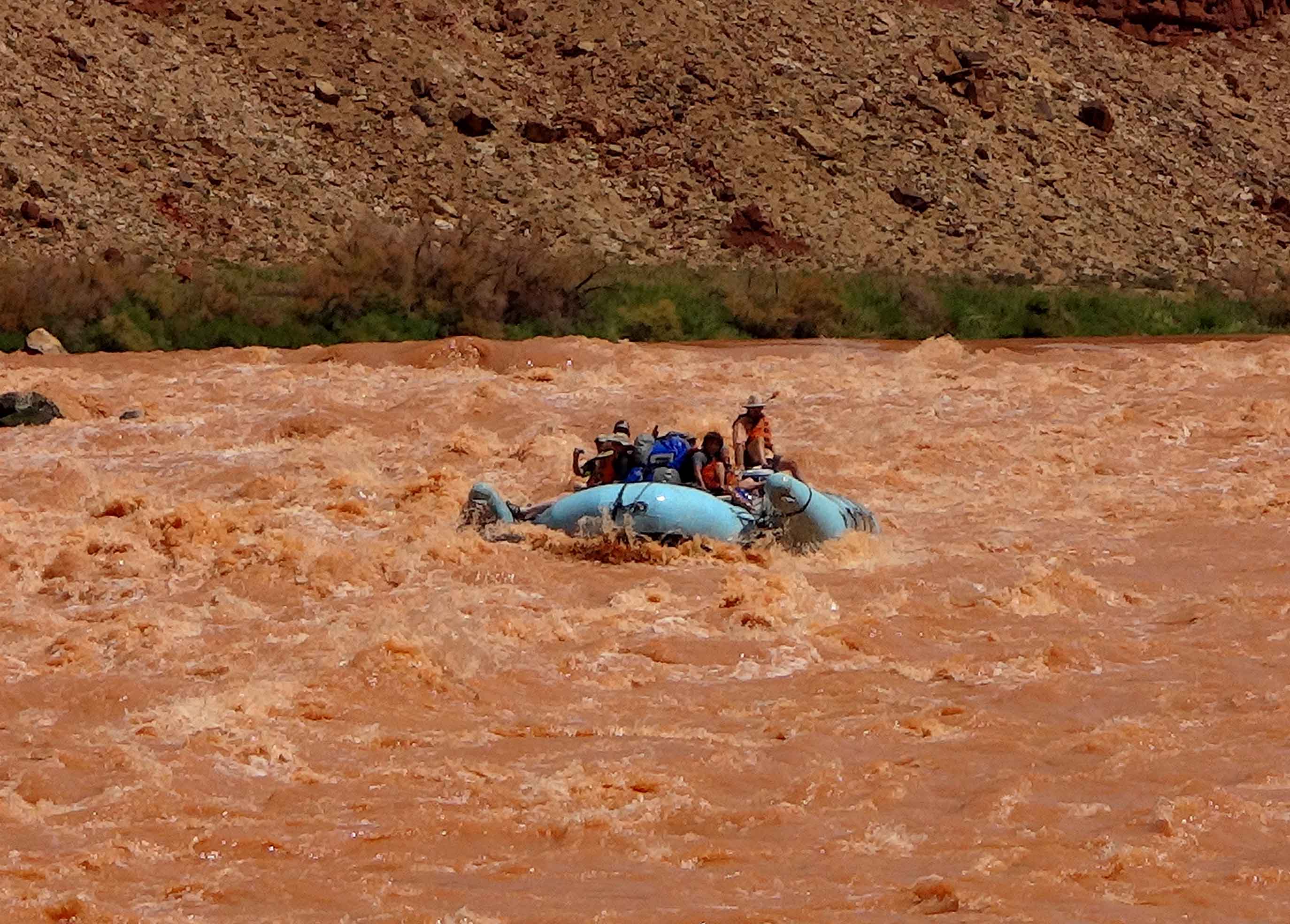
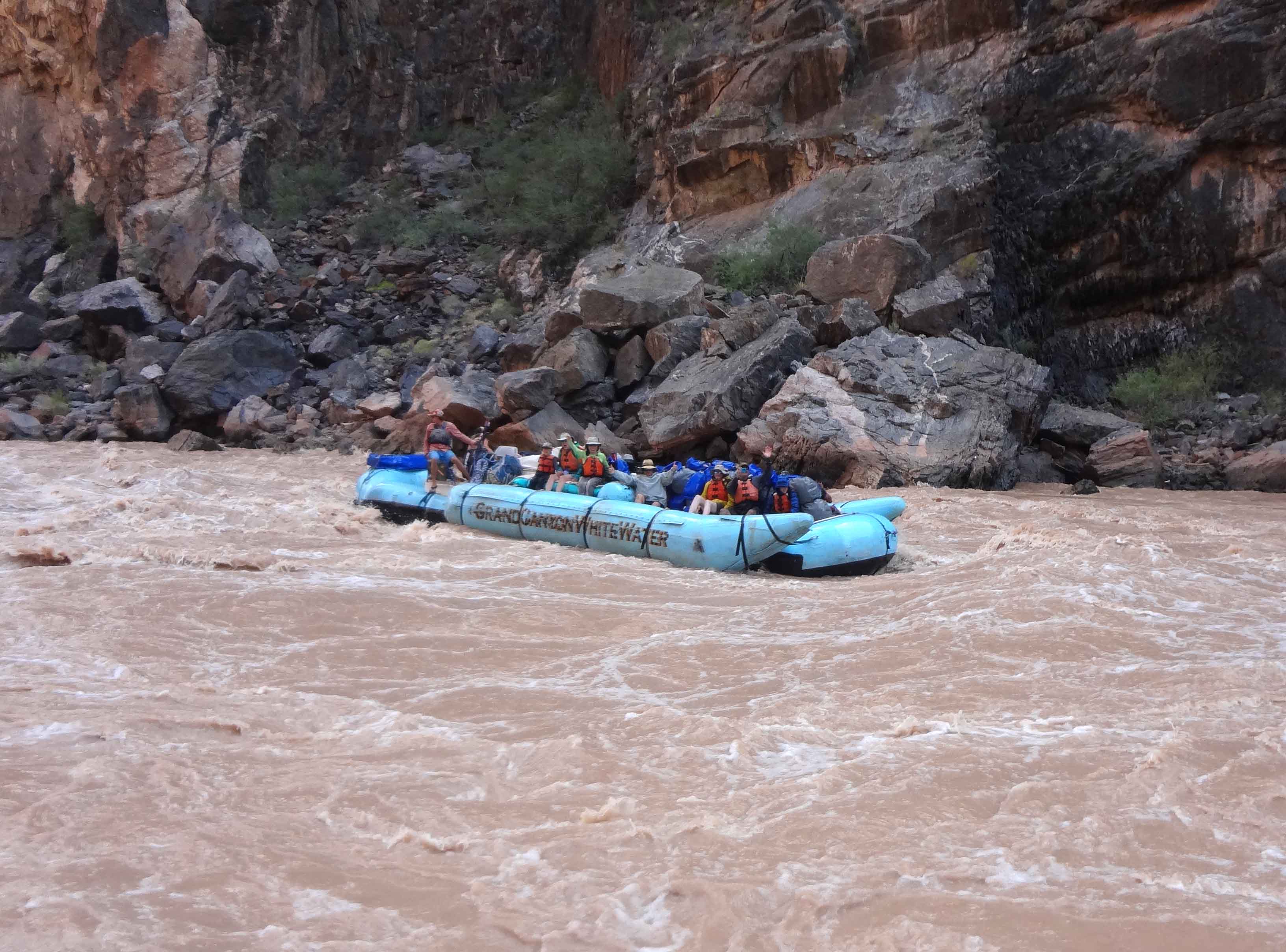
The afternoon began with three smaller warm-ups for the big whitwater to come, namely 164 Mile Rapid (4ft drop, rating 2), Fern Glen Rapid (Mile 168.5, 3ft drop, rating 2) and Gateway Rapid (Mile 171.9, 10ft drop, rating 3). We all knew that the biggest rapid, Lava Falls, was fast approaching and were bracing ourselves for that descent. Vulcan's Anvil, a prominent 50ft high lava plug in middle of the river, signals that the most feared rapids are not far ahead. Just upstream I was able to identify the Toroweap Overlook, 2500ft above us on the right side. Many years ago I had driven over 60 miles of dirt road to get to that spectacular viewpoint and enjoy the vertical vista around it. Moreover, I had climbed down the very rough semi-trail that leads from the Overlook to the Colorado. It had been a very tough hike (especially climbing back up 2500ft in the midday sun). Now, floating past 11 years later, I was able to discern the last section of my descent route just downstream of the Anvil. On that early expedition I had hiked along the riverbank to watch the boats descend Lava Falls. The smaller boats beached before the falls to scout out the best route, left or right of the big hole, called the Ledge Hole, in the middle of the river. On the other hand the larger boats simply went right through the Ledge Hole which would easily flip the smaller boats and occasionally the larger ones. Now I was to go through the hole myself. Holding on especially tightly, we descended into Lava falls or the Vulcan Rapid (Mile 179.7, 13ft drop, rating 8-10) as it is properly called. Formed primarily by debris flows descending Prospect Canyon, the large lateral canyon on the south side, the Ledge Hole did indeed provide the most exhilerating experience of the trip with the boat reaching its most extreme inclination. However, the run was soon over and we could look back to watch the second boat descend without incident. Another, smaller falls, Lower Lava Rapid (Mile 180.1, 14ft drop, rating 3-4) was easily run before we stopped for the night at Lower Chevron Camp on the right bank at Mile 183.
 | 
| |
|---|---|---|
| Approaching Lava Falls | Lava Falls trail |
 | 
| |
|---|---|---|
| Lava Falls Rapid | At Whitmore Helipad |
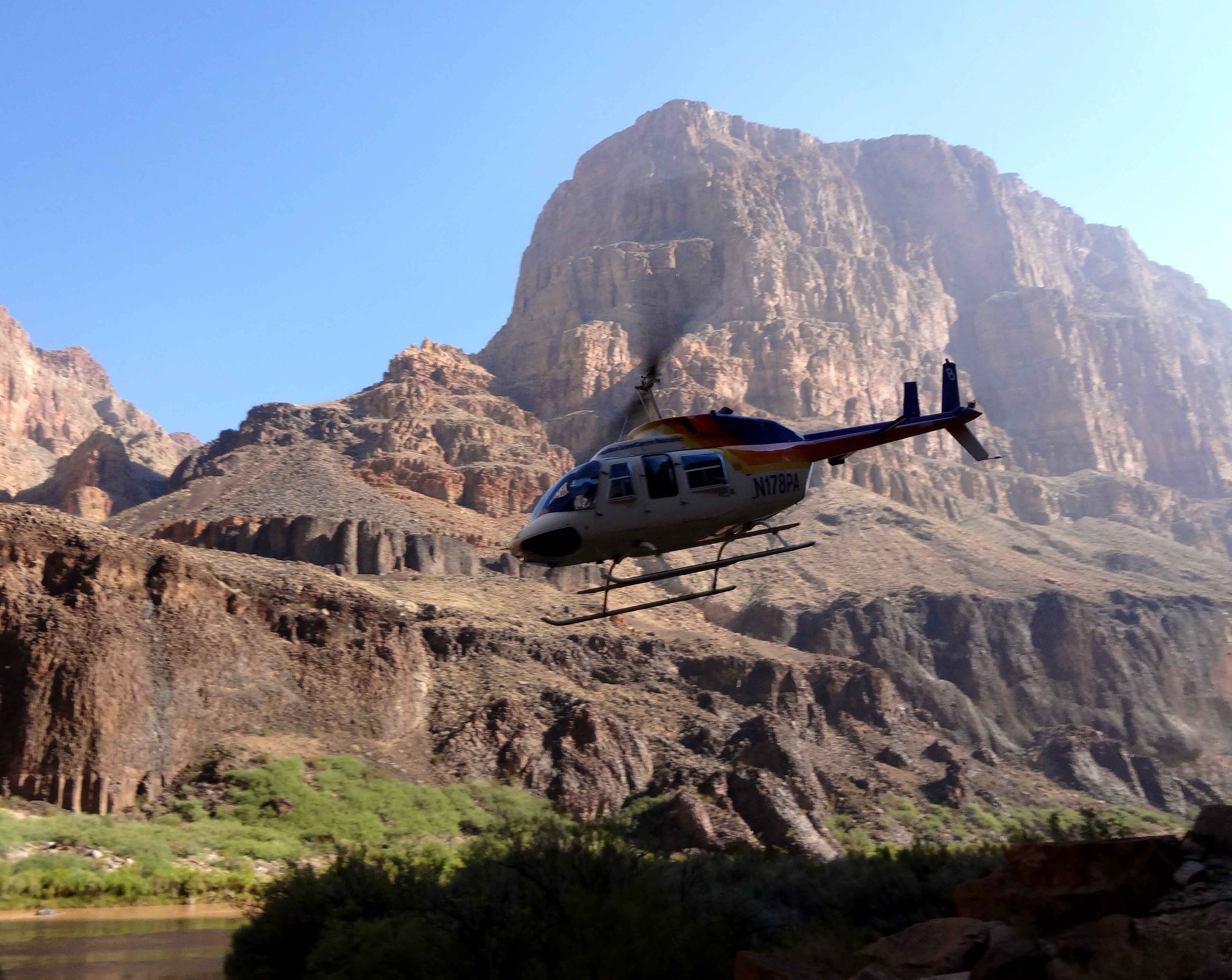
It was with a combination of regret and excitement that we awoke on this last day and prepared for our departure from the canyon. After the modest 185 Mile Rapid (2ft drop, rating 2) we pulled into the left bank at Mile 187.4, the location of the Whitmore Helipad. There a wizened old employee of the helicopter company, a river legend called Garth, organized us according to our weight for the helicopter that would carry us out of the canyon and up to a ranch on the mesa to the north would only carry six, and the weight of those passengers had to be properly distributed in the chopper.Once organized we waited on this small beachhead below the cliffs for the Bell Lone Ranger 206 helicopter to arrive. It seemed quite unreal as the lone pilot flew a short distance upstream between the great sandstone cliffs before turning and setting down on the small sandy clearing that served as the Helipad. Having already said their goodbyes to the four crew members (who would be taking the boats almost 100 miles further downstream to the Pearce Ferry Take-Out where they would be disassembled and trailered back to Lee's Ferry), the first six passengers were hustled into the chopper which took off again immediately for the nine minute flight to the mesa high above us. This procedure was repeated five more times, including one flight exclusively for the baggage. The flight was truly awesome as the chopper swung downstream and rose over the edge of the great sandstone walls and then turned north for the brief flight to the Bar 10 ranch about 9 miles north of the river.
This adventure outpost was fully equipped to tend to the needs of people who had spent a week in the canyon. The hot showers were a delight and we lunched in preparation for the rest of our journey back to "civilization". Horizon Air operates small fixed-wing flights from the dirt strip at the Bar 10 Ranch to Las Vegas and to Marble Canyon. Most of us embarked on two flights to Marble Canyon and were back where we started in about an hour.
It was a truly awesome adventure in a really unique place. We had descended more than 73 major rapids (and many smaller ones) distributed over 180 miles of river in what is still one of the most remote places on earth. In that whitewater we had dropped through about 1400ft of elevation without a single incident thanks to a highly skilled crew who not only supplied all our needs but also entertained us with poetry and song.
One can only hope that the Canyon will remain unspoiled in the centuries that come, that our grandchildren will be able to share their experience of it when they are 71 years old. Though the commercial river expeditions in the Grand Canyon may be more of an intrusion than the purists would like, the public opinion thus generated will likely aid in the Canyon's preservation and, maybe, restoration. Hopefully, it will not be desecrated by any more construction and what is there will be trimmed. Maybe, even, the Glen Canyon Dam will be removed to return this wonderful river system to its natural state during our grandchildren's lifetime. For as the iconic Edward Abbey has projected: For if we don't do it Nature will. In a few more centuries
the dams will be filled with mud and sand, will become great waterfalls and then, as erosion does its work, will be reduced to stumps of concrete and re-bar, .. . This is already happening to many smaller, abandoned dams in the West such as the Rindge Dam in Malibu Canyon.
Last updated 10/18/13.
Christopher E. Brennen