THE FAR SIDE OF THE SKY
© Christopher Earls Brennen
THE LILIES OF CHOKAI
``Both heaven and earth
come from one's own heart''
Traditional Shinto saying.
Mountains have always figured large in the religious and social landscape of Japan. Perhaps this is so because in such a densely populated yet mountainous country where the flatland had all been developed for agriculture, the only wilderness left in which to seek privacy for meditation and prayer was in the mountains. Moreover, it was evident that the mountains brought the rain that was so important to the crops, particularly the rice. And so even in the ancient shamanistic belief system known as Shinto the mountains were believed to be the home of the spirits and the place where dead souls went to rest.
Then, in the sixth century came a major influx of Chinese religions and traditions, both Taoist and Buddhist. Shinto beliefs became inculcated with these more sophisticated philosophies and the ancient sacred mountains evolved into refuges for Buddhist monks and hermits. With the growing reputation and influence of these men, their mountain refuges and temples naturally became pilgrimage destinations and venues for annual religious retreats. Sects evolved that combined the ancient traditions with Buddhist beliefs, most notably the movement known as Shugendo or the way (do) of mastery (shu) of extraordinary religious power (gen). Shugendo traces its origin to a legendary ascetic called En No Gyoja who lived near Kyoto during the Nara Period in the late 7th century. It teaches ascetic practices that are to be conducted upon certain mountains and lead to magic religious powers including spirit possession, exorcism and faith-healing. Its leaders are regarded as living ``kami'' or Buddhas and its followers are known as ``yamabushi'' (wandering mountain ascetics). To this day, yamabushi, dressed in flowing pantaloons and checkered smocks, make annual pilgrimages on many sacred mountains, visiting the shrines at each of the ten stations (reflecting the ten precepts of Buddhism) on the way up the mountain and practicing a wide array of purification formulas and traditions. When they descend from the mountain they visit their friends to administer blessings from the mountain or perform special services of healing or exorcism.
The religious goals are as diverse as their organization and amount to the application of religious magic to almost any human need. Because of its simple shamanistic roots, its loose organization and lack of specific textual doctrine, Shugendo had a strong appeal for the ordinary folk and became very popular throughout Japan from the 12th century onward. Especially in the north, almost all village shrines came to be served by Shugendo priests.
One of the great attractions of these oriental religions is that they are largely inclusive. This stands in marked contrast to the exclusivity of many western religious sects. The inclusivity means that the shrines at regular intervals on the trails up the sacred mountains (and by extension the less sacred ones) welcome all comers and a tradition has developed of trying to accommodate any and all travellers who come that way. Thus today, the shrines or stations on the popular mountain trails largely serve the secular purpose of providing an overnight rest stop for multitudes of hikers with little or no religious purpose. For a western explorer they provide a fascinating insight into Japanese culture, society and traditions.
Some of the great volcanoes have an association with one particular segment of Japanese society and such is the case with Mount Chokai, the bird (cho) sea (kai) mountain. A great stratovolcano that has erupted 30 times since 573 A.D. (most recently in 1974 when the eruption lasted 2 months), Chokai-san lies close to the Japan Sea in a region of northern Honshu known as Tohoku. The shadow that it casts on the Japan Sea is a famous sight known as Kage Chokai. Because of this proximity to the sea, Chokai is the abode of deities who control navigation and the safety of seafarers.
Chokai-san lies on the border between Akita praefecture to the north and Yamagata to the south. In 1704, the peak was the stage for a local dispute between the Yashima clan from Akita and the Shonai clan from Sakata in Yamagata praefecture. The Yashima claimed the Shonai were infringing on their rights. But the Edo government, no doubt influenced by the fact that the Shonai were ten times larger in terms of rice production, ignored the Yashima suit. The temple at the top is said to have been originally dedicated by En No Gyoja to ``Chokai Daigongen'', an avatar. The present O-monoimi jinja or shrine at the top was originally located at the seventh stage of the mountain, Nabemori. Up until the Meiji restoration, temple construction was undertaken by both sets of believers. In the Meiji Era, however, the Chokai temple was taken away and the O-Monoimi Shrine was built.
The narrow road winding up the flank of the massive mountain was dark and deserted on that August morning of the year 2000 as we drove toward the trailhead before dawn. The eirie shadows reminded me of a story I had read in the Mainichi Daily News just a few weeks earlier:
Mainichi Daily News, Monday, June 5, 2000:
Yashima, Akita - A hike on a mountainside here turned tragic after a man picking bamboo shoots was mauled to death by a bear, police said.
Police officers found the body of 62-year-old Shozaburo Kamata on Mount Chokai at around 6:50 a.m. on Sunday. The wounds to his head and arms bore bite wounds and claw marks, and investigators discovered what appeared to be the tracks of an Asiatic black bear near the body. Police have concluded that Kamata died of massive loss of blood.
Officers began searching Mount Chokai on Saturday morning after another man gathering bamboo shoots in the area reported seeing a body lying on the mountainside.
Kamata's family told police that he often went to Mount Chokai to pick bamboo shoots.
The whereabouts of the bear are unknown
Maybe he was just waiting at the trailhead for the next yamabushi - or, better yet, a juicy gaijin!
We were Yoichiro Matsumoto, Takashi Tokamasu and myself. We had set out from Sendai for Chokai Quasi-National Park in Yamagata prefecture the preceding day and had stayed overnight at a guest house or ryokan called Chokai-sanso (``Chokai Cottage'') situated at the base of the mountain, close to the starting point for the Yunodai trail up the mountain. The Yunodai hotsprings were one of the featured attractions of the guesthouse. We had left the inn (elevation 1640ft) in the pitch dark and started up the steep winding road, leaving the developed land behind as we climbed through thick low forest, mostly bamboo but increasingly mixed with deciduous trees. The demons vanished as dawn broke over Tohoku. Soon the sunrise blazed crimson and orange across the mountains of northwestern Honshu and promised a glorious day on the great mountain. After a 20min drive we came to the parking area at the end of the road at an elevation of 3910ft; not much here but a small structure for sightseeing obviously constructed to function in deep snow. And we could now see a number of substantial snow fields higher on the mountain.
By the time we left the trailhead the red streaks in the eastern sky were turning to orange. The roughly paved trail climbed steeply through thick, low forest. After just 15min we came to a clearing at 4167ft with the substantial, two-storey Taki-no-koya or ``Waterfall Lodge''. Interestingly, there was another entrance door at the second level for use under deep snow conditions. This early in the morning it seemed deserted. The benches out front provided a convenient place for us to enjoy the Japanese breakfast that Matsumoto had brought for us, complete with hot coffee.
A substantial stream runs close by Taki-no-koya, and the trail beyond the lodge followed this stream for a few hundred yards to a small snow field. The stream had cut a curious ice-tunnel under the snow field that I had to investigate. Higher up, the water cascaded over a steep rim creating a lovely waterfall. The trail switchbacked through low scrub up a steep and rocky trail, eventually cresting this rim. Beyond it, we found ourselves on a large shoulder on the mountain with an expansive meadow of low bamboo scrub interspersed with grass. Here, after 1hr of hiking, we came to the second lodge, Kawara-juku or ``Riverside Inn'' beside the stream at 5052ft. It was a more modest, single storey wooden structure containing a tatami sleeping area and a small shrine. This was Shichi-gome, the 7th station on the Yunodai trail.
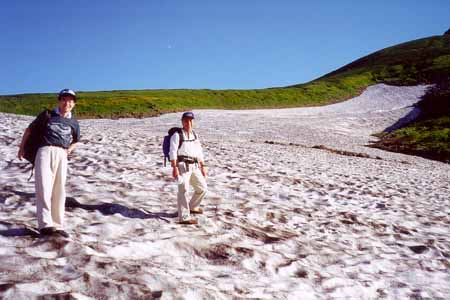 | 
| |
|---|---|---|
| Ascending the first snowfield | On the summit of Chokai |
We stopped to rest on the veranda in front of the inn. The sun seemed to be warming us all in preparation for the next obstacle, visible at the end of the meadow. There on the southern face of Chokai, were two large snowfields or small glaciers. Leaving Kawarajuku, the trail followed the stream along to its origin, the base of the lower and larger glacier. We stepped gingerly onto the ice surface testing the footing. Here, near the bottom, the slope was gentle and the ice surface was sufficiently dirty and dimpled to provide adequate footholds and friction. Thus we climbed more easily than I expected up the lower slopes of the glacier. When it steepened higher up we moved to the rocky terrain on the left. We passed low woods off to our left, known as Bosa-mori or ``Bosa's forest''. Climbing to where the slope of the glacier eased again, we resumed our hike on the ice and crossed to the right side where the trail in the rocks climbed past the head of the snow field. I noted an interesting yield line or trough across the snow at the top that may have been where the snow began to move. From there, the trail traversed left to another smaller glacier known as Shin-ji-yokee, or the heart-shaped snow field. This we quickly crossed, climbing to the right and coming to a steep, rocky section of trail through thick low brush. The route here is called the thistle trail; it climbs to the top of the ridge that we had been ascending for the past hour.
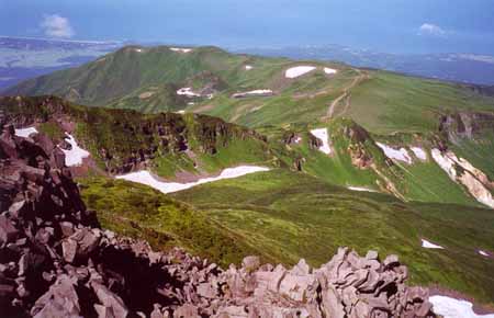
I pause here to try to describe the geometry of the summit area of Chokai. Unlike the boring cone of many volcanoes, the rugged top of Chokai is sliced through by a great trough that divides the summit pinnacles into two groups and then curves down the side of the mountain, emptying into the foothills to the west. The summit block itself is thus separated by the trough from the great sloping ridge on which we now stood after a 2hr 45min hike from the trailhead. Here at 7000ft the crest of the rim is called Fushi-ogami-dake or ``Deep Pray Mountain'' presumably because the scene revealed when you attain the ridge is, indeed, awe-inspiring. This point is also marked on the map as the site of Ku-gome, the 9th station, though there was no structure to be seen. But the view of summit was spectacular, the great trough with its snow field curving down from the peak spires and passing below us. In the distance, below the summit block and on the north slope of the trough, we could see the famous temple.
From Ku-gome, the trail follows the south rim of the trough on its way toward the summit. The map says one of the projections from the rim is a peak, Gyoja-dake, named for the famous ascetic but we passed this unknowingly. A 30min hike up along the rim brought us to a trail junction (elevation 7140ft) where we left our packs before the short, 10min walk on up the rim to its highest point. This 7316ft peak is called Shichi-ko-san, or ``seven high peaks'', and from it you get a great view across the head of the trough to the collection of rocky spires that make up the summit block. It had taken 3.5hr to climb from the trailhead to here.
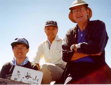
From Shichi-ko-san, we returned to the trail junction where we had left our packs and then followed the steep trail equipped with chains down the side of the trough to the icefield at the bottom. Crossing the snow field it was but a short climb up the other side to the temple (elevation 7040ft). Again we deposited our packs and made our way up the steep rocky trail toward the summit. As we neared the top the trail deteriorated to arrows painted on the rocks and some steep bouldering was needed in order to reach the base of the pinnacles on the summit. Arrows pointed to the tallest spire, that could not have otherwise been identified from several equally impressive monoliths. A final section of rock climbing took us to the 10ft by 10ft platform on the top of the highest pinnancle. This summit of Mt. Chokai is called Mount Shinzan (7335ft), or ``New man (peak)'', perhaps because it rose to be the highest within the memory of man. It had taken us 4hr to get to the summit.
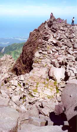 | 
| |
|---|---|---|
| The summit of Chokai | View to the east |
The drop-off around the summit pinnacle lent added drama to the spectacular 360 degree vista that greeted us at the top, the Japan Sea to the west, and range after range of the mountains covering northern Honshu off to the east. The summit was equipped with the usual small shrine, a carved stone altar of considerable weight. It must have been quite a feat to carry it all the way up the mountain. Offerings on the altar included not just the usual coins but unopened pieces of wrapped candy including chewing gum! Around us were other pinnacles almost as high and we climbed one other to the west of the summit. Too soon it was time to move on and we quickly descended back down to the temple.
From the temple we began our descent by a different route, taking the trail that decends from the temple along the north slope of the great trough. This eventually dropped into the bottom of the trough and followed the snow field that fills it. Near the bottom of the snow field the trail contoured up the south wall to the same rim we had ascended early in the morning but now at a lower elevation. We joined the trail along the rim at a place called Shime-kake, ``sacred straw festoon rack'' and then continued down along to a saddle on the rim ridge where the trail forked. Here we forked left, leaving the rim and traversing across to a crater lake called Tori-no-umi (``Bird Lake'') or Chokai-ko (``Chokai Lake''). We reached here 6hr 45min from the start.
Our water supply was beginning to run low and we were anxious to descend to the stream we thought we detected some distance below us. Consequently we took just a brief look at the lake lying some 100ft below us in an old crater and then returned to our trail. A steep descent of several hundred feet brought us to the base of an ice-field where the snowmelt formed a crystal clear stream. Here we enjoyed a marvellous Matsumoto lunch, smoked salmon on french bread, tomatoes chilled in the stream, cheese, mushroom soup, and chilled oranges washed down with ice-cold water and later by hot coffee. It was so good I think I dozed off for a few moments, lying in the soft meadow grass under a warm sun.
About an hour later, we stiffly resumed our descent quickly reaching the boulder-filled streambed that runs through the big valley we were now following. Forking left at a trail junction, we came to a relatively flat valley bottom with rolling parkland and a network of streams. Around us were patches of low bamboo scrub and large open meadows with short grass, carpets of flowers and shallow meadow pools. It exuded a sunlit serenity in contrast to the raw mass of the stratovolcano now high above us. But most special were the forests of flowers, saffron lilies and purple foxgloves twinkling in the mountain air. The lilies were the color of sun and the color of monks. It seemed so natural that they should point the way to the house of contemplation high above us.
Day-dreaming our way across this land, we passed another trail junction with the picturesque name Ja-seki-ryu-bunki or ``Snake stone stream fork''. From there we veered left and traversed across open meadows toward the base of a long high ridge to the east. At the base of this ridge, the trail left the meadows and climbed up a steep rocky streambed toward a saddle on the ridge. Near the top the saddle broadened into a flatter meadow area, again with grassland, flowers, pools and streams. Off to the right was a forest named Gassan-mori for the sacred mountain, Mount Gassan (``Moon mountain'') some distance south of Chokai. Gassan had been visible to us most of the day. Cresting a few low ridges the trail brought us back to Riverside Inn about 9hr 30min after the morning start.
Other hikers were resting quietly at the Inn, enjoying the late afternoon sun and the water from the stream. The lilies were beginning to close for the night and the snowfields looked considerably colder. Hastened by the changing light, we gathered ourselves and moved down the trail we had climbed earlier in the day. Passing Takinokoya without stopping, we reached the trailhead just about 10hrs after our morning start. From there we drove back to Chokai-sanso for a most welcome onsen before returning to Sendai.
So another adventure in the land of the rising sun came gently to
an end. Sometimes the journey itself, the pilgrimage, is enough for it
creates a space in which to consider the world you know and your place
in it. When that journey is embellished by the beauty of the mountains
and the flowers, it makes it easier to find an equilibrium of the soul.
And so it was with this adventure, marked by contemplation of pilgrimage
and the beauty of the lilies. Of the color of the flowers and the sun.
Last updated 9/1/00.
Christopher E. Brennen