OF LOVE AND EXPLORATION - AN AUTOBIOGRAPHY
© Christopher Earls Brennen
WILDERNESS
``With a host of furious fancies
Whereof I am commander,
With a burning spear, and a horse of air,
To the wilderness I wander.
By a knight of ghosts and shadows
I summoned am to tourney
Ten leagues beyond the wide world's end.
Methinks it is no journey.''
From ``Tom O'Bedlam'' (17th century, anonymous).
On Christmas Day, 1983, at our temporary home on South Holliston Avenue in Pasadena, Doreen, the children and I were celebrating our traditional family Christmas. I do not recall anything that would allow my memory to separate that day from dozens of other delightful Christmases except for one thing. Instead of the traditional gift from under the Christmas tree, at the conclusion of that ceremony, Doreen, Dana, Kathy and Patrick wheeled in a brand new mountain bicycle. It was, perhaps, the best Christmas gift I ever received. The timing was perfect for I had had my eye on one of these new bicycle designs and was, at the same time, looking for a form of exercise that would not only improve my health but also be fun. It was a brand new Schwinn Mirada and seemed to require virtually no effort to propel. Shortly thereafter I began to make short trips into the nearby San Gabriel mountains. For the first few months I would impose upon Doreen to give me a ride up the tortuous road to Mount Wilson and, from there, I would ride down one of the two fire roads to Pasadena. Later I began to venture onto the various trails around Mount Wilson and into the canyons of the several forks of the San Gabriel river. During the week I would pour over my maps of the mountains, plotting out my next trip, making sure of the distances and the elevation changes. As my horizons widened, and my ambitions grew, one particular adventure began to intrigue me. I had, on several occasions, riden some distance on a trail up the East Fork of the San Gabriel River starting at the end of the road above Azusa. I noticed on the map that this canyon ran almost the whole way through the San Gabriel range. Indeed if one climbed up the Blue Ridge above Wrightwood on the northern side of the mountains then one could drop down from Vincent Gap into Vincent Gulch and, from there, into the canyon of the East Fork of the San Gabriel. My map indicated a trail through this canyon that one could follow all the way to the south end and thus emerge onto the road above Azusa. I recognized that this would be a very ambitious traverse but I reasoned that, if I started early and had the advantage of a downhill ride the whole way, then I should be able to make it. Circumstances were to prove otherwise.
Thus it was that very early on the morning of Saturday, Nov.11, 1989, Doreen and I set off for the Angeles Crest Highway which winds for about fifty miles along the spine of the San Gabriel Mountains. From La Canada Flintridge we climbed about 5000ft through the morning haze, past Red Box junction which had so often been my drop-off point and on to Charlton Flats, the Chilao Visitor's Center and Newcomb Ranch. I knew that Doreen was getting a little impatient as we climbed further and deeper into the mountains. Finally, when we reached the 7018ft Cloudburst Summit about 9.00am, I felt that I had reached a good starting point. So I turned the car around for Doreen, unloaded my bicycle and we parted ways, Doreen to return home and I to continue along the Angeles Crest Highway.
The air was crisp and filled with the morning scent of the pine trees as I rode along this beautiful road in the sky. Several gentle descents and ascents took me past the Eagles Roost and through the Mount Williamson tunnels to Islip Saddle where a precipitous road once connected with Route 39 coming up from Azusa. The road between Islip Saddle and Crystal Lake having been wiped out once too often by floods and earthquake-generated land slides, the State had given up trying to maintain that section and had allowed it to return to its natural condition. During previous adventures, I had navigated the remains of this route on my bicycle. This time my objective lay further along the Angeles Crest Highway and so I began the climb from Islip Saddle, past Mount Hawkins and Throop Peak to Dawson Saddle, at 7903ft the highest point on the Angeles Crest Highway. At Dawson Saddle I had come about 11 miles from my starting point at Cloudburst Summit. From there it was a swift and exciting ride of about 3 miles down to the 6560ft trail junction at Vincent Gap which I reached at about 11.30am. There I paused for lunch and reflection before continuing the next stage of my planned trip. Already I was somewhat apprehensive about the limited amount of daylight remaining. However I reasoned that, provided the trail that appeared on my map existed (and I had no reason to think that it did not for the map had proved reliable elsewhere), I should be able to reach civilization again before dark.
With eager anticipation, I left the road at Vincent Gap, following the trail that drops fairly steeply down Vincent Gulch toward the Mine Gulch junction. This is rugged, forested country and, during the descent, I entered the Sheep Mountain Wilderness, the home of a substantial herd of Nelson Bighorn Sheep and a number of bears and cougars. The forest was a mix of conifers and deciduous trees whose autumn colors added to the spectacular scenery. The 9399ft Mount Baden-Powell formed a dramatic western wall to the canyon. About a year later I climbed this mountain, named after the founder of the Boy Scout movement. In the register at the summit I placed this message:
``Oct.6, 1990. In memory of my father Wilfred M.Brennen (1911-1987) who, as Chief Commissioner of Scouting in Northern Ireland, worked tirelessly to reduce sectarian violence by bringing together Catholic and Protestant youth within the Scouting Movement. Today he would have been 79.''
Though steep the trail was mostly rideable and I made fairly good progress with only the occasional need to carry my bike. I paused a number of times to admire this beautiful land. After a descent of about 2000ft from Vincent Gap, I emerged onto a flat area of sand and rock, the 4500ft Mine Gulch junction where Vincent Gulch, Mine Gulch and Prairie Fork all meet before the sum of their contents plunges into the canyon of the East Fork of the San Gabriel River. Another trail drops down to this junction from the Cabin Flat campground on Prairie Fork; it used to be possible to reach Cabin Flat campground by car using a dirt road from the Blue Ridge above Wrightwood. Indeed as I approached the Mine Gulch junction I came upon two young men who had hiked down Prairie Fork from Cabin Flat. They seemed truly amazed when they spotted me riding my bicycle towards them and looked at me with even greater astonishment when I told them of my destination.
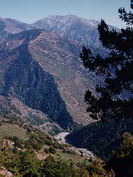
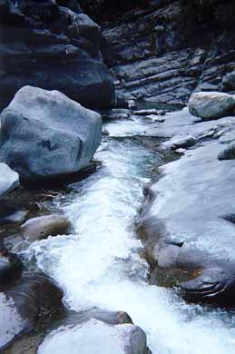
It was shortly after leaving Mine Gulch junction and entering the East Fork canyon that I realized that I might be in some difficulties. First, it rapidly became obvious that the nice red line on my map that indicated a trail through this canyon was entirely fictitious. If there had ever been such a trail all traces of it had long been obliterated by the winter torrents that crash through this canyon. Second, time was marching on and, with only a few more hours of daylight left, it was clear that I would not be able to make my way out of this wilderness before nightfall. For the moment there was little choice but to press on. It would have taken me several hours to climb back up the way I had come and, after all, there was always a chance that a good trail would suddenly appear at some point further downstream. The terrain was now even more rugged and precipitious. The mountains on both sides had closed in, forming a canyon with unscaleable walls and a rock-strewn bottom. The river in the canyon was a substantial stream with alternating quiet sections interspersed with chaotic rapids. In many places it was neccessary to carefully select a route by which to descend amidst waterfalls and large canyon-filling boulders. It was slow going, carrying or dragging a bicycle which, at several points, needed to be lowered by rope ahead of me. In still other places the canyon bottom was entirely overgrown with young saplings (alders?) that could only be penetrated with great difficulty. It was, indeed, a rugged wilderness.
I did attempt to keep track of my location but landmarks were rarely visible from the canyon bottom. Glimpses of the 8009ft Iron Mountain immediately to the east of the canyon did however allow some estimate of my position. As the light began to fade I guessed that I was somewhere in the vicinity of Fish Fork at an altitude of 3400ft and about 7 tough miles from Vincent Gap. Ahead of me I still had two very hard miles of rugged canyon before connecting up with the trail that I knew led south from the ``Bridge to Nowhere'', about which more later. Each time I turned a corner in the canyon, I kept hoping that I would see this imposing bridge but my calculations told me it would not be possible to reach it during the available daylight. The temperature had begun to fall and, since I was soaking wet from having travelled in the stream, I began to get cold. Moreover, both bicycle tires had gone flat probably because of water in the valves and they needed to be repaired. All of these factors clearly indicated that I should find a comfortable place to spend the night. It would be very dangerous and quite impossible to press on in the dark. Any injury caused by a fall could turn the situation from serious to critical. And, yet, it took all the will-power I could muster to make myself stop and prepare for the night. Panic was a powerful force causing me to keep going. But commonsense finally prevailed and I chose a spot on a sandy bench where I built a rudimentary stone fireplace. Dry, downed logs were abundant nearby and I soon had a substantial fire going. I was immensely thankful to Doreen for adding a small butane lighter to my bicycle kit only a few weeks before. In retrospect it is clear that this lighter saved me from a very threatening situation and made it possible for me to make it through the night in relatively good shape.
Once the fire was going I began the time-consuming but important task of drying my clothes and shoes. This took about two hours but I was able to complete the task before it became too cold. As it turned out the weather was very mild for November and the temperature did not fall too far at anytime during the night. At the end of two hours I had clothed myself in every garment I had with me and was reasonably dry and comfortable. During the drying process the only mishap was a slightly burnt sock, now missing part of its sole. I scooped out a place in the sand right next to the fire and lay down for the night. Though I was not able to sleep, I was able to rest in a warm and fairly comfortable position. For most of the night the moon was quite bright and I could look up and see the stars and the occasional airplane passing high overhead on its way to Chicago, New York, or dozens of other destinations. I reflected upon whether I would rather be down here or up there in one of those aluminium cigars and I was not entirely sure I knew the answer. Most of all, the night was extremely boring. I tried to resist looking at my watch every five minutes and eventually was able to stretch the interval to every twenty minutes. Many, many times I attempted to relieve the boredom by intricate planning of my remaining resources. In this regard, the most critical resource was water. I had about a pint of orange juice and a pint of water remaining. I decided to consume the orange juice through the night, saving some for ``breakfast'', and to keep the water for the next day. Though I was fairly sure the stream water was safe in such a remote region as this, I did not want to risk drinking it until it became necessary, primarily because I feared illness. I did have a little food left in the form of two small packs of crackers and cheese (the kind available in vending machines) and two pieces of Doreen's shortbread. Before settling down I dined on one pack of crackers and cheese and one piece of shortbread downed with orange juice. The other pack of crackers and cheese provided my breakfast and I kept the final, sugar-laden piece of shortbread as emergency glucose rations.
So I was reasonably comfortable in the middle of the Sheep Mountain Wilderness. On the other hand, back home in Sierra Madre, Doreen became increasingly alarmed as the sun set and the evening wore on without any word from me. I had told her that I would call once I emerged from the canyon and that I would need a ride home from Azusa. When no such call came by about 9.00pm, Doreen concluded that something had gone wrong, and she rightly felt that she had no choice but to call the sheriff and the mountain rescue team. Fortunately, I had given her a quite explicit description of the route I was going to take. So when she finally reached the appropriate office within the Sheriff's department, she was able to provide them with an accurate description of my route. They told her that there was little they could do before morning, but they were organizing two search teams, one that would start down the trail from Vincent Gap, and the other would set off up the trail from the East Fork Ranger Station. These teams would probably be ready to start about 10.00am the next morning. In the meantime, they said they would call her every hour or so to let her know whether there had been any developments. It was a truly agonizing experience for Doreen, and the aspect of the whole adventure that I regret most is that I caused her this pain.
| 
| 
| ||
|---|---|---|---|---|
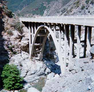
| Prairie Fork junction from | In East Fork Narrows | Bridge to Nowhere | ||
| Big Horn Mine |
As soon as light began to penetrate the canyon, I consumed my meagre breakfast and made preparations to resume my journey. I inspected the tires of the bicycle and decided not to use the spare inner tube until I reached a rideable trail. Finally I doused the fire, and set off down the canyon. The going continued very rugged indeed but I began to detect signs of human passage and then encountered a substantial canyon junction where there were clear signs of human activity. This I assumed was Iron Fork (3200ft); I recognized the flattened area where goldminer George Trogden had his camp at the turn of the century. George was well known for his hospitality to all who passed this way. Occasionally things got out of hand as on Christmas night, 1917, when the gunslinging goldminer John Portwood shot and killed miner Herman Miller after a poker game. Indeed the East Fork of the San Gabriel river was the site of a gold rush during the latter part of the 19th century after the precious metal was discovered there in 1855. Below Iron Fork, the canyon is dotted with mines and the remnants of tailings. Even today several prospectors still live and work in the canyon while a number of weekend panners take out a few dollars worth of the gold for several hours work.
Below Iron Fork a rudimentary trail became detectable and I began to encounter other hikers travelling in both directions all of whom were more than a little surprised by my bicycle. Though I had begun the morning feeling quite fresh I did notice that my strength began to ebb quite quickly and it became harder and harder to lift my bicycle. I started to debate whether I should abandoned my much-loved vehicle but, apart from my sentimental attachment to it, I also realized that once I reached the Bridge to Nowhere it would be easier to ride from that point on than it would be to hike. And so I pressed on. Toughest of all was the fact that, in several places, the trail climbed the canyon wall in order to get around waterfalls; it was becoming very hard to find the strength to negotiate such obstacles. Finally, however, after one such ascent part of the way up the west wall of the canyon, I turned the corner and there was the bridge. My relief was tangible for I knew I had the capability to ride from here down to the trailhead and the ranger station.
The Bridge to Nowhere is one of the most bizarre artifacts to be found in the San Gabriel mountains. Back in the 1920s, Los Angeles County planned to build a highway all the way up the East Fork canyon to the Mine Gulch Junction. From there the road would climb over Blue Ridge and drop down into Wrightwood. It would be among the most scenic roads in America. Construction began in 1929, most of the work being done by County prison work crews. By the mid-1930s the highway had reached The Narrows (2800ft) where the East Fork flows through a very deep gorge, the deepest in Southern California. There it was neccessary to construct a concrete bridge high above the waters of the gorge. A tunnel was also chiselled out of sheer rock. However, the winter after this difficult construction task had been completed, an unprecedented storm arrived on March 1-2, 1938, depositing many inches of rain on the San Gabriel Mountains. The result was a tremendous flood that roared down the East Fork, obliterating everything in its path including more than five miles of the painstakingly constructed highway. Only the bridge was high enough above the waters to be virtually untouched. The futility of the project having been so emphatically demonstrated, the County abandoned their plans leaving a brand new concrete road bridge standing alone in the middle of the wilderness more than five miles from the nearest highway. It became a popular destination for hikers who dubbed it the ``Bridge to Nowhere''. Years later the County planned another highway up the East Fork. This time they intended to build it high up on the western wall to avoid a repetition of the earlier disaster. Begun in 1954, this second highway was abandoned in 1969 after only 4.5 miles had been built. That second effort left substantial scars up on the western wall. Hopefully that will be the last time man will desecrate this wilderness and it will be left for future generations to enjoy in its nearly natural state.
I reached the Bridge to Nowhere about 8.30am and, high above the rushing waters of the East Fork, sat down to summon my strength for the last leg of the journey through the wilderness. I could not help but admire again the spectacular Narrows gorge below me. There are two ways up the canyon at this point. One is to follow the trail up the canyon wall, cross the Bridge to Nowhere and then descend along a trail to the canyon bottom. That is the easy way though it is not obvious since the canyon makes several turns during this traverse. Those who fail to find the place where the trail takes off to climb to the bridge must make their way along the canyon bottom, a much more difficult route. I was glad that I had located the trail for I fear I would not have had the strength for the Narrows bottom route. After a few minutes, I turned my attention to the tires of my bicycle and was able to make sufficient repairs so that I could ride on two inflated tires. It was a great relief to be able to mount my bicycle for the first time for about 19 hours and thus to make fairly easy progress toward the trailhead, some five miles away. Despite the fact that the day hike to the bridge is fairly popular and therefore this trail is well travelled, the frequency with which it gets washed out means that it is quite rough in places. Indeed it crosses the East Fork perhaps a dozen times between the Bridge and the trailhead. Normally it is fun to ride through the stream at these crossings but, on this morning, it was more of an effort. I had consumed the last of my water on the Bridge and began to recognize some of the symptoms of dehydration and exhaustion, a slight sense of confusion and disorientation. But I felt that the situation was under control as I negotiated the last stream crossing, climbed the bank, and entered Heaton Flat where goldminer William Heaton set up camp in 1891 and prospected until his death in 1924. A few hundred yards more and I came to the locked gate at the trailhead parking lot. I had travelled 14 miles through the wilderness and a total of about 28 miles since Doreen had left me on the Angeles Crest Highway.
Though I had not given the matter much thought, I nevertheless half expected to find a welcoming party of some kind at the trailhead. Since no such welcome occurred, I guessed that Doreen had not called the authorities as I expected she would. But my first priority was the water fountain where I was surprised by how thirsty I was and consumed about a quart of water. I also filled all of my water bottles in preparation for what I anticipated might be a ride of as much as ten miles to the nearest telephone. The entrance to the ranger station is right beside the water fountain and, as I was filling my bottles, a ranger drove by in his pickup truck. I thought that he looked at me somewhat unusually but since he drove on I thought no more about it at the time. After a brief rest, I felt ready to resume my journey and so started off down the East Fork road. After about half a mile, I paused briefly at the junction with the Glendora Mountain Road for no special reason that I can recall. As I stood straddling my bike, the same ranger who had passed me earlier drew alongside and leaned over from the driver's seat to speak to me. He asked me whether I was Chris Brennen. In later retellings of the story I have sometimes claimed that I hesitated before responding and made a mistake in saying yes. In fact, I meekly responded in the affirmative, recognizing that I was near the end of my resources and that I probably needed some help. Within moments it seemed as though I was surrounded by about four or five emergency vehicles. I realized later that they had been about to set off on their search for me, and that they were headquartered at Williams Camp, about a quarter of a mile down the road from where I had stopped. That accounted for the speed with which they appeared once they were notified by the ranger. I had little choice in the succession of events that followed. They took my bicycle away from me and made me sit down by the side of the road. There they did a quick check of my condition, taking my pulse, my temperature, and my blood pressure, in addition to checking my lucidity. Shortly thereafter they drove me down to Williams Camp for a more extended examination and debriefing. Someone brought me several small cans of orange juice that tasted very good indeed. They also called Doreen to tell her that I was safe and well and that she should come and get me at Williams Camp. Having determined that there was little wrong with me other than thirst they then quizzed me about how I had spent the night and about the condition of the trail, if any. In fact they did not seem to know a great deal about the canyon north of Iron Fork. Eventually, they left me to my own devices while they reviewed their own preparations for the rescue attempt. During this time I realized that they were virtually all volunteers who gave of their own time in the service of the search and rescue teams. I confess that several times it crossed my mind that I might get an enormous bill for their services. Fortunately I never did. I do, however, have a lasting appreciation for the work they do and for their thoughtfulness and generosity.
Doreen arrived with Patrick and drove me home to Sierra Madre. They were, perhaps, too relieved to express appropriate anger over my antics. I was very glad to see them and was almost asleep in the back seat by the time we arrived home. I slept for a while and awoke refreshed toward the end of the afternoon. I assumed that was the end of the matter. However, when I opened the local newspaper, the Pasadena Star-News, the next morning, Monday, November 13, a headline jumped out at me: ``SHERIFF'S DEPUTIES FIND TWO MISSING CYCLISTS''. The story, which is completely erroneous geographically, read:
``Angeles National Forest. Search teams from the Crescenta Valley Sheriff's station were called out to find two separate cyclists Sunday in the San Gabriel Mountains. Deputies found Christopher Brennan, 48, near Crystal Lake just before 10 a.m. Sunday, nearly 24 hours after his wife had dropped him off on San Gabriel Canyon Road above Azusa. Brennan reportedly misjudged the time neccessary to make his trip and was forced to spend the night in the mountains. Later in the day.....''.
So much for my notion that the adventure would pass unnoticed by those outside of my own family. When I got to my office, one of the secretaries, Jackie Beard, had made a big enlargement of the newspaper article and plastered it on my office door and elsewhere in the building. There was also a telephone message from the President's office asking me to call them. This I did quickly, trying to reassure them that I was both safe and sane. Later that day, I learned from a number of people that the story had been on the local radio. Indeed the story spread like wildfire through the Caltech community and I acquired a reputation that I had no way of controlling. The legend grew in the telling; indeed, it seems to have been passed down in more and more exaggerated form from one generation of graduate students to the next. At a graduate student banquet about a year later, my students Steven Ceccio and Douglas Hart presented me with a special kit for future trips. This consisted of a fluorescent yellow hat and a bright red tee-shirt with the following message in large letters on the chest: ``IF FOUND RETURN TO CALTECH''. When I climbed Caltech Peak with Douglas several years later, I made a point of having my picture taken on the summit wearing this outfit.
And so I come to the end of this story. For me it was not a
particularly trying ordeal though it was undoubtedly traumatic for Doreen and
Patrick. When I think about those 27 hours, I reflect on my gratitude to
Doreen for a small butane lighter and for caring about me. But I am also
discreetly proud that I was able to handle a difficult situation quite
successfully.
Last updated 7/30/99.
Christopher E. Brennen