OF LOVE AND EXPLORATION - AN AUTOBIOGRAPHY
© Christopher Earls Brennen
SORAKSAN
``Old men ought to be explorers
Here and there does not matter
We must be still and still moving
Into another intensity.''
From ``East Coker'' by T.S. Eliot (1943).
In the summer of 1992, I was scheduled to attend two conferences in the far east, one in Seoul, Korea, and one the following week in Hangzhou, China. This meant that, along with one of my former students, Steven Ceccio, and other participants, we had an intervening weekend to indulge in whatever activity we wished. Steven and others had elected to spend that time in Hong Kong since that city was a necessary transit point on the way to Hangzhou. They also seemed to be attracted by the shopping opportunities Hong Kong provided, a feature that had no appeal whatsoever to me. Nevertheless, since I thought it might be interesting to see the Crown Colony, my initial flight plan was the same as that of my colleagues.
I think that it was during the long flight from Los Angeles to Seoul that I began reading a guide book for Korea, and started to take notice of the photographs of the rugged and beautiful mountains of Mount Soraksan National Park. Several times I returned to those pictures, and a possible alternative weekend plan began to form in my mind. One of the problems, however, was how to get there. Mount Soraksan is in the far northeast corner of South Korea, above the famous 38th parallel, and not far from the DMZ (de-militarized zone) that separates South Korea from North Korea. It therefore lies on the opposite side of the peninsula from Seoul and, although only about 150 miles(?) as the crow flies, the journey is a tortuous one because of the mountainous terrain and the deliberate lack of railways so close to North Korea. To reach the Park, it would be necessary to travel to Sokch'o, a fishing center on the eastern coast. This could be reached either by a 40 minute flight or by a 5.5 hour express bus ride from Seoul. During the first couple of days of the conference in Seoul, my plan began to take concrete shape. If I could catch the flight from Seoul to Sokch'o on Friday afternoon, I could then spend Saturday hiking and catch a return flight to Seoul on Sunday morning in time to connect with a flight to Hong Kong. I finalized this rather tightly scheduled itinerary on Tuesday and looked forward with anticipation to my adventure in Korea. Only one prerequisite remained. With the help of one of the student aides at the conference, I located a map shop in Seoul where I purchased a hiking map of Mount Soraksan that had some English subtitles.
In the early afternoon of Friday, August 28, 1992, I took the free airport shuttle bus from Hotel Lotte in downtown Seoul to Kimpo International Airport, leaving adequate time to navigate the domestic terminal and catch the late afternoon Korean Air flight to Sokch'o. As I waited for the beginning of check-in to be announced, a message flashed on the screen: the flight to Sokch'o had been cancelled due to weather conditions at that airport. Unlike other parts of the world, that seems to be the end of the story in Asia; you then queue for a refund and are on your own in so far as alternate travel plans are concerned. I sat there bewildered, trying to figure out what to do next. I could return to my original travel plan and give up my visit to Soraksan. Or I could try to find my way to Sokch'o by express bus. The cosmopolitan nature of air travel means that, in airports, one can be fairly confident of finding someone who speaks English should difficulties arise. Bus travel is, however, a completely different story, and so I was somewhat apprehensive about setting off in a bus for a fairly remote corner of Korea. But my sense of adventure got the better of me, and I soon found myself on a crowded city bus bound for the Seoul express bus terminal.
Thanks to a kind lady on the city bus to whom I communicated my destination by means of bus sounds, I alighted at the correct stop next to the large and scattered complex known as the Seoul Express Bus Terminal. Fortunately, each major destination had its own ticket booth and, after some searching, I finally located the Sokch'o booth, identifiable because I had memorized the Korean symbols for that city. The 5.00pm bus was fully booked, but I was able to purchase a ticket for the 5.30pm bus. The bus itself was clean and comfortable. Initially I failed to realize that I had purchased a ticket for a specific seat, and so had to be asked to move from my first stop near the front of the bus. However, my spirits were quickly revived when a beautiful young Korean woman in a red suit took the seat beside me. I guess she had no choice. I had the impression that she was a little taken aback by the strange foreigner in the seat beside the one allocated to her.
The bus set out on time for the five hour journey and initially travelled quickly on a brand new freeway. However, after an hour or so we turned onto a narrower, two-lane road called (somewhat inappropriately) the Yong Dong expressway. This wound its way through the mountains that occupy most of the western part of the Korean peninsula. We passed through very pleasant countryside, valleys filled with farms and separated by ridges of mountains. The land was green, the valleys fertile and the mountains covered in trees. Traffic was heavy on the Yong Dong Expressway and so our progress was slow in places but otherwise the bus travelled quite quickly. At one point the young woman beside me seemed to summon the courage to offer me a can of fruit juice she was carrying. I declined but worried that I might thus have offended her.
Daylight was dwindling as we passed the city of Wonju and the peaks of Ch'iaksan National Park off to the south. With the advent of sunset the young woman and I embarked on our first conversation. Though her English was very limited, we made some progress thanks, in part, to the phrase book chapter in my guide book. Apparently, she worked in Seoul and was returning to her family in Sokch'o for the weekend. Like me, she had been booked on Korean Air and had to make alternate plans when that flight had been cancelled. The bus then arrived at a way station called Hoenggye in the mountains just south of Odae-san National Park. Here restrooms and food-stands were set up to serve the needs of bus passengers. I tried to find something to eat that I both recognized and could consider reasonably safe. I did not do very well. The young woman in red realized this and bought some delicious fried corn that she shared with me when we reboarded the bus. As we resumed our journey through the night, the weather worsened and it began to rain heavily. Worse still for the prospects of my hike the next day, the mist reduced visibility to about 20 yards. In these miserable conditions, the bus followed a long and windy road that descended from the mountains to the eastern coastal plain. We passed close to Kangnung and then turned north, following the coast toward Sokch'o. The bus stopped again at a rest stop where the 38th parallel meets the eastern shore. In Korea this latitude has considerable historical significance. Following the Second World War, Russia, Britain and the United States struck a deal in which Russia was to occupy the peninsula north of the 38th parallel and the United States the land south of that line. The dispute over this boundary eventually flaired into the Korean War in which one side and then the other pushed deep into the other's territory. When the final armistice was signed, it established the current border and the broad Demilitarized Zone (DMZ) not far from the 38th parallel. On the east coast the border and the DMZ are some miles north of the 38th and hence the location of the bus stop has real signifcance for the Korean people. A large monument marked the exact location of the 38th parallel.
My new guide helped me again, this time to get some very-welcome hot coffee and we then set off on the final leg of our journey as heavy rain continued to fall. The bus passed through the coastal village of Yangyang and, a few miles further, the woman in red pointed out the junction where the road to Mount Soraksan National Park joined the coastal highway. By then we had reached the outskirts of Sokch'o and very shortly thereafter stopped at the very rudimentary Sokch'o bus stop consisting of a small, and almost unlit, shelter. Without the help of my new found friend I would have been left standing in the dark and the rain without much idea what to do next. There were taxis that pulled up and embarked bus passengers but none seemed to have any interest in a stranger. However, my friend buttonholed one cabbie who was headed for Sorak and persuaded him to add me as a passenger. And so I hurriedly put my luggage in his trunk and squashed into the front seat. In the rain I had only a moment to thank the woman in red and to say goodbye. I tried to give her my umbrella for she had none and the rain was still pouring down; but I could not make myself understood and she would not take it. Time was too short even to understand what she said when she told me her name. As the taxi raced away in the rain I was saddened that I would never be able to write to her to thank her for her kindness to a stranger. I also reflected on how often, in the furthermost corners of the earth, I had met kind and gentle people who had given me help when I needed it.
The cabbie had been directed to take me to Hotel New Sorak where I had a reservation and it was not long before I was checking in. The hotel, which was relatively modern and clearly designed for westerners, seemed almost deserted. Though the guidebook said they spoke English, I had great difficulty making myself understood. Nevertheless I was soon settled in a pleasant room and began organizing my hiking gear for an early start in the morning. As well as my boots, clothes, rain gear and emergency kit, I had brought my small back pack with me in anticipation of a hike such as this. And in Seoul I had purchased some provisions such as bananas, crackers, canned fruit and orange juice. And so I went to sleep hoping that the weather in the morning would be substantially improved. I woke with the dawn, and was delighted to find that the rain had stopped and that the mist had cleared. From my window I could see that the hotel was in a broad canyon in the foothills of the mountains. Below me a fast and full river carried the substantial run-off of the last few days to the sea a few miles to the east. The rugged and steep, tree-covered mountains rose dramatically to the west though the higher elevations were still hidden in the clouds. My excitement grew as I anticipated some marvellous hiking and very soon I was walking up the road toward the entrance to the National Park about a half mile away. Here a substantial complex of souvenir stands and snack shops had been built to cater for the bus loads of tourists (mostly Korean schoolchildren) who visit the Park every day during the season. But as I walked through at 6.00am, the place was deserted. I intended to follow the trail toward the highest point in the Park which is sometimes known as Mount Sorak or Soraksan but whose proper name is Taech'ongbong Peak. I was not at all sure that I could reach that destination in the time available that day. The summit was about 11km. away at an altitude of 5607ft and my hiking map suggested that it would take 6 hours and 20 minutes to get there. I would have to travel significantly faster in order to make it there and back during daylight.
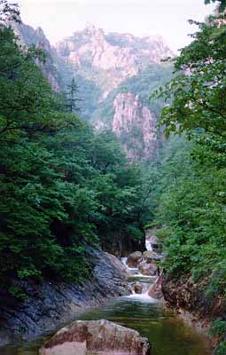
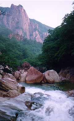
The trail is initially broad and easy as it follows the main river valley past a series of snack bars and souvenir stands located at regular intervals along that part visited by the average tourist. It is a delightful valley with abundant mixed forest, waterfalls and pools. The weather was clearing rapidly and allowed me a view of the rugged mountain pinnacles for which this area is so well known. The sun even broke through and made the walking even more delightful. Soon the trail steepened, the canyon closed in and the scenery became more and more spectacular. The Park Service had installed metal bridges and staircases to allow one to cross the river or negotiate particular places that would otherwise have needed climbing gear. These bridges and staircases occurred with increasing frequency as I progressed upstream. The trail itself also became noticeably rougher. In a dry climate like California's, the trails often get ground down to a fairly flat surface; on the other hand the rainfall in this part of the world washes away the finer material leaving a rough, rocky surface that is considerably harder to walk on. Soon I left the tourist area behind and entered the backcountry which only experienced hikers penetrated. I met several groups of hikers who were obviously returning having spent several nights in the wilderness. And here I began to encounter a curious phenomenon. The Koreans are very keen on hiking but the interest is primarily confined to the younger members of the educated class. Most of them have studied English extensively and are usually very keen to take any opportunity to practice conversation with a native English speaker. The further up the mountain I progressed, the more likely it was that anyone I met would fit into this category. Consequently, the further I penetrated the wilderness the more likely it was that anyone I met spoke English. Somehow that seemed very strange to me.
At just about the time I began to feel hungry, I reached a particularly beautiful set of waterfalls and pools and so I sat down to consume my mid-morning meal of bananas, crackers and canned fruit washed down with orange juice. Though odd, the meal was just what I needed for it contained lots of sugar. Soon after lunch, I encountered a young German couple who were descending and stopped to chat. They had clearly become somewhat dispirited by the downpour of the previous day during which they had tried to reach the peak. The rain and the mud had made for very hard going; they had given up the attempt and suggested that I would find it equally impossible. That was momentarily discouraging for I thought I had been making good progress up to that point.
 |  | 
| ||
|---|---|---|---|---|
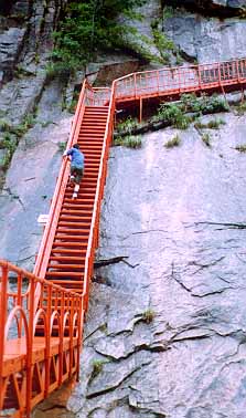
| View from trail | View from trail | Metal Staircase |
A few yards later I came upon the first back country rest stop called Yangp'ok Shelter. Initially, I was not sure what to make of this shelter. It consisted of a small wooden shack with an awning and some benches arrayed in front of it. The front of the shack was constructed like a street vending stall and a limited range of goods were displayed for sale. There seemed to be hard-boiled eggs, candy bars and an assortment of canned drinks. Some of these were recognizable, for example the ubiquitous soft drink cans, Coca Cola, 7 Up, etc. Other products one could guess at by the pictures on the label, for example some of the orange juice cans. But other goods were labelled only with undecipherable Korean letters. All of these goods must be hauled in on the backs of the people who operate the rest stops and tend the vending booths. They seemed friendly though clearly unused to foreigners. The prices were a little high and, I would find out, rose as one ascended the mountain. But that seemed only fair. I purchased some orange juice and candy and also a can of Pocari that I had read somewhere was the Korean equivalent of Gatorade, though the name Pocari apparently means something like pig sweat. At any rate, it tasted very like Gatorade and I was glad to have identified it. Sitting down to enjoy my Yangp'ok snack, the other features of the rest stop came to my attention. A short distance away was a rudimentary two story brick building with openings rather than doors and windows. A number of young Korean hikers were seated in the openings packing their gear and lacing up their boots. I recognized that establishment as one of the hostels I had read about where one could spend the night under a roof for a very modest fee. I wondered, idly, what the place smelt like. But I quickly reprimanded myself for such a culturally-biased thought; chances are it was quite clean though I never checked. Finally I also recognized that the raison d'etre for this rest stop was the presence of a nearby shrine that I did not visit.
Just beyond Yangp'ok Shelter the trail entered a truly precipitious canyon where passage was only possible because of the metal gangways and staircases. In several places these hung precariously from the sides of cliffs several hundred feet above the river. Progress required a good deal of effort to suppress my fear of heights. At the same time the canyon was fantastic, particularly the spectacular Ch'ondang Falls which came into view as the canyon made a left hand turn. Eventually, I came to a point where the canyon levelled out and the metal walkway ended; here the trail left the river to climb a steep and fairly high slope to the ridge above. This climb was quite hard for the temperature had risen and it had become quite humid.
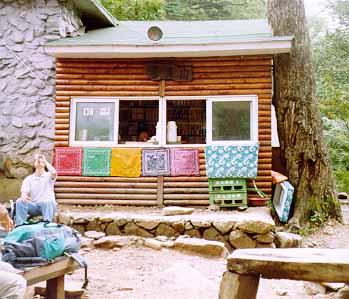
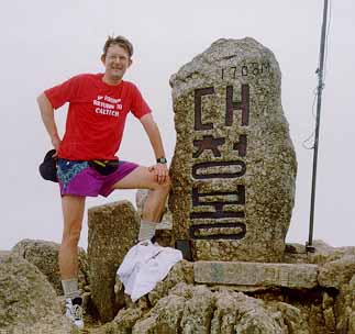
After many switchbacks, I finally reached the ridge and shortly thereafter the second rest stop known as Huiun-gak, equipped with vending shack and overnight shelter. Here, again, I purchased Pocari and sat down on one of the benches to enjoy a rest. A number of other young Korean hikers were similarly resting and struck up a conversation with me. They seemed genuinely impressed that an old (and presumably dissipated) Westerner could make it that far in one day and somewhat dubious about my prospects of making it to the top. The man tending the booth also joined in and, through translation by one of the young hikers, pointed out the best way to the summit. Patchy clouds were beginning to roll in as I started up the steep trail that followed a ridge to the summit. Though there were many places where I had to find toe and hand holds to ascend the ridge, the trail was well travelled and the climb was not too difficult so I made steady progress over the last 2000ft. The view at many points was quite spectacular, and made other-worldly by the patchy clouds below me. In several places I could look down over 2000ft to the valley through which I had come. Moreover, one could look north over the DMZ into North Korea though there were no visible signs of that demarcation line. Close to the summit, the clouds closed in completely so it was something of a surprise when the trail emerged onto a broad ridge leading to the peak about a hundred yards away. The cairn at the summit was decorated with several inscribed monuments, including one large one with the Korean characters corresponding to Taech'ongbong, the official name of the peak. Even up here there was a rest stop though it was discreetly placed about a hundred feet down the windswept slope from the summit. Again I bought a can of Pocari; at this elevation it cost about a dollar for a small can. There were some other low huts beside the vending booth but I could not discern whether they included an overnight shelter. I rested for a while and listened to the wind.
 | 
| |
|---|---|---|
| Huiun-gak shelter | On Taech'ongbong Peak |
I could have tried to descend by a different route but eventually decided to take the safest course and retrace my steps. The descent was tiring and, because of the roughness of the trail, hard on the ankles and knees. By the time I approached the bottom, I was quite exhausted and stopped at several of the tourist shops for orange juice or Pocari. Unlike my passage in the early morning, this time the bottom was filled with crowds of schoolchildren. My fatigue made me impatient when they got in my way. They looked at this strange Westerner with puzzlement and I could not help but wonder what they thought. I stopped in one of the tourist shops for some supplies and then, exhausted but exhilerated by a marvellous day of hiking, returned to the hotel and a most welcome rest. After much difficulty, I was able to obtain a tuna fish sandwich from room service and prepared for an early start in the morning.
The morning brought rain and low clouds, and I felt very fortunate to have had such pleasant weather the previous day. I had arranged for a taxi to take me to Sokch'o airport for the early morning Korean Air flight to Seoul. There I would connect with my Korean Air flight to Hong Kong. However, when we arrived at Sokch'o airport, I discovered that my flight was cancelled yet again because of the weather conditions. Others arriving to catch the same flight departed resignedly as though this were a not unexpected occurence. I protested that I would not be able to catch my flight to Hong Kong. The ticketing agent then engaged my taxi driver in animated discussion, the outcome of which was a plan to get me to Seoul in time to catch the flight to Hong Kong. The taxi driver would drive me to the airport in Kangnung (about 80km down the coast) in time to catch a flight from Kangnung to Seoul. And so we set off at breakneck speed along the narrow two-lane coastal highway. The driver seemed to revel in the challenge. Many times I closed my eyes and prayed. In the end we made it to Kangnung airport with time to spare and the flight to Seoul allowed me to catch the flight to Hong Kong with little difficulty. It was somewhat depressing to find myself enclosed again by aluminum and plastic. It had been another marvellous adventure in an out-of-the-way corner of a strange land and in a park of enchanted canyons and pinnacles. And I will always remember the woman in red.
Originally published in abbreviated form in the Korea Times,
August 30, 1996.
Last updated 7/30/99.
Christopher E. Brennen