OF LOVE AND EXPLORATION - AN AUTOBIOGRAPHY
© Christopher Earls Brennen
CALTECH PEAK
``.......so I used the move .......to do a little
course track for him. I know how, Skipper. I read
the manual. It's easy, just like we used to do at
Caltech to chart star motion....''
From ``The Hunt for Red October'' by Tom Clancy.
In 1991, the California Institute of Technology, my place of work for many years, celebrated its 100th birthday. In July of that year graduate student Douglas Hart and I marked our own celebration of the centennial by climbing the 13,832ft Caltech Peak near the northern boundary of Sequoia National Park in California.
Caltech Peak became the official name of a mountain about 15 miles northwest of Mount Whitney in December of 1961. Previously unnamed, the peak came to be identified with the Institute as a result of a weekend climbing trip by Jim Eder ('65), Dick Jali ('55) and Ted Matthes ('55) who made the third recorded ascent on June 25, 1961, following the route that we took 30 years later. The three Caltech alumni were struck by the fact that three California schools had nearby mountains named after them, namely Mount Stanford (Stanford University), Trojan Peak (University of Southern California) and University Peak (University of California). So, after their return, they petitioned the Department of the Interior and the Superintendent of Sequoia and Kings Canyon National Parks. After some months of successful lobbying, Dick Jali was able to tell the Caltech community of the naming of the peak in a letter published in the January 1962 issue of Engineering and Science. Since that time a number of alumni, staff and students have made the ascent, and been rewarded by the magnificient view from the summit. There is no campus record of those ascents. But we do know of a number of members of our community who have made it to the top in the thirty years since it was named Caltech Peak. On Aug.16, 1964, Thor Hansen (1964) left a glowing description of Caltech in the summit register. Five years later Eric Jensen (1970) and Roger Jensen (ex 1971) reached the top on Aug.21, 1969, and they were followed a couple of weeks later by Volker Vogt (1964). James Greenfield, the director of corporate relations, and Dick Mooney from the business services office climbed the peak on Aug.19, 1970. Dale Dalrymple (1973) made the ascent on Sep.12, 1971, spent the night on the summit, and made his way along the ridge to Mount Stanford the next day. Margaret Schaefer was probably the first female member of the community to make it to the top. She climbed the mountain by the more difficult western approach on Aug.20, 1972, in the company of her husband, William P. Schaefer, then the Registrar at the Institute. Bill, who was probably the first faculty member to reach the top, reported on their experience in a November 1972 letter to Engineering and Science. He also climbed it for the second time in 1978. To my knowledge, the only other faculty member who made the climb prior to myself was Professor of Mathematics, David Wales, also at one time Dean of Students.
My own interest in attempting the climb was formed from several different motivational strands. In the preceding few years, I had taken up mountain biking and mountain climbing as a recreational pursuit and in an effort to regain my health after some years of neglect. I had gradually progressed to higher altitudes including climbs of Mount Baldy, Mount San Jacinto, and Mount San Gorgonio. The High Sierras beckoned next. But an additional motivation became established about 1989. My friend Louis Wilde, then Master of Student Houses, knew of my efforts to recover my health and of my mountain-biking exploits in the San Gabriels. At one point during a conversation with Louis, I rashly claimed that I could ride my bicycle to the top of Mount Baldy, a claim that was met with ribald disbelief. I recall a comment to the effect that I was ``too old and too fat'' to accomplish that feat. When I was so quoted in a campus publication, Louis protested that he had been misquoted. What he had said was that I was ``too old and too feeble'' to make it to the top. To maintain my self-respect I had no option but to challenge these slanders. I thereupon issued a ``Centennial Challenge'' to Louis that ran as follows. If, as a Centennial celebration, I could make it with my bicycle to the top of (i) the 9,138ft Throop Peak in the San Gabriel mountains and (ii) the 13,832ft Caltech Peak in the Sierra Nevada then he, Louis, would have to meet me at the second location. I would bring my wife's battery-powered horse shears and would be permitted to give Louis whatever haircut and beardcut I so desired. Shortly after this challenge was accepted, I completed the first leg of my task in June 1990 and so recorded the fact in the register at the top of Throop Peak. Perhaps frightened by the possibilty that I might actually succeed in the challenge, Louis had his hair and beard cut during the fall of 1990, and so greatly reduced the incentive for me to take my bicycle with me. In the end, I carried a symbolic, plastic toy bicycle that I left at the summit in recognition of my friendship with Louis. By that time I had also recognized the magnitude of the task of getting to the top of Caltech Peak even without a bicycle. Besides, bicycles are not permitted on the trails in the National Parks.
So it was that Doug Hart and I set off on July 23, 1991, to climb Caltech Peak and, perhaps, also Mount Whitney. We drove separately to Lone Pine where I obtained a wilderness permit from the Mt. Whitney Ranger Station. Pine. A limited number of permits are issued each day for entry to the wilderness through each of the High Sierra trailheads. Permits for the Mount Whitney trail beginning at Whitney Portal must be obtained many months in advance. However, other trailheads are much less popular, and we had no difficulty obtaining our permit for the Symmes Creek trailhead to the Shepherd Pass trail, the next entry point north of Whitney Portal. After last minute shopping, we left Doug's car at Whitney Portal in order to allow us to exit the wilderness from that point, and then drove on up US 395 to Independence. From there we navigated a route over dirt roads to the 6000ft Symmes Creek trailhead using the High Sierra Hiking Guide by Winnett. Spending the night there, we were on the trail shortly after dawn on July 24.
The Shepherd Pass trail is a long and, at times, arduous climb of about 6000ft. It begins with a series of switchbacks that ascend to a saddle at 9000ft between the Symmes and Shepherd creek valleys. This saddle provided the first of many truly exhilerating experiences on the trip for, quite suddenly, there unfolds a breathtaking panorama of the 14,375ft Mount Williamson and the dramatic cliffs that surround it. The memory of this magnificence lingers long after one leaves the saddle and begins a brief descent into the valley of Shepherd creek before the trail starts upward again.
| 
| |
|---|---|---|
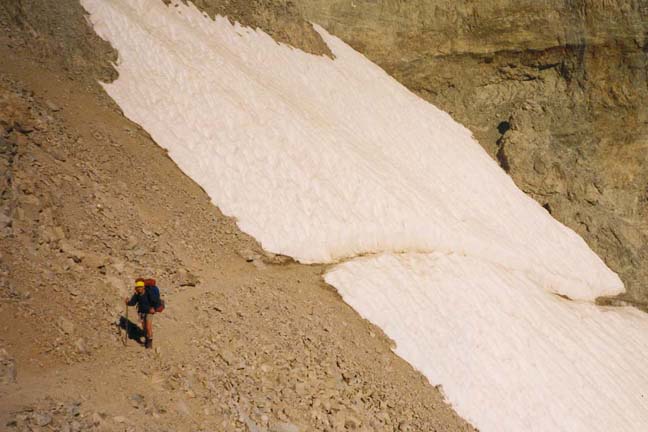
| Climbing toward Shepherd Pass | Shepherd Pass |
After lunch at a stream-crossing below Mahogany Flats, we resumed our climb up the valley. For me that afternoon was, perhaps, the toughest leg of the whole trip for the sun was hot and I was still adjusting to the altitude. The climb up to and around a very large moraine blocking the valley was exhausting. Late in the afternoon, we both struggled into Anvil Camp which is perched among the trees on top of the moraine. Perhaps because of our fatigue, we camped a little too close to the stream and were attacked by mosquitoes who seemed to find Douglas particularly tasty.
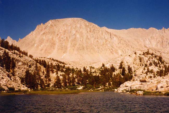
The next morning was clear and beautiful, and the views were magnificent as we climbed through increasingly rugged terrain toward the 12,050ft Shepherd Pass. The last part of the climb switchbacked up a quite dramatic chimney and traversed a small snow field before we finally reached the top of the pass. The view of the High Sierra that opens up as one achieves this summit is awe-inspiring. The mass of 14,018ft Mount Tyndall lies to the south, most appropriate for this location since it is named after the English scientist who first explained why the sky is blue. The northern skyline consists of the angular outline of Diamond Mesa which, for the moment, obscures the view of Caltech Peak. Below one's feet to the west are gently sloping meadows where Tyndall Creek begins and, in the distance, a marvellous panorama of Sierra peaks. Shepherd Pass also marked our entrance to Sequoia National Park and, because of this, several posted signs greeted us at the summit. One, in particular, I found puzzling. It read ``No loose herding beyond this point''. ``Loose herding'' being undefined I was not at all sure how I could avoid an inadvertent transgression!
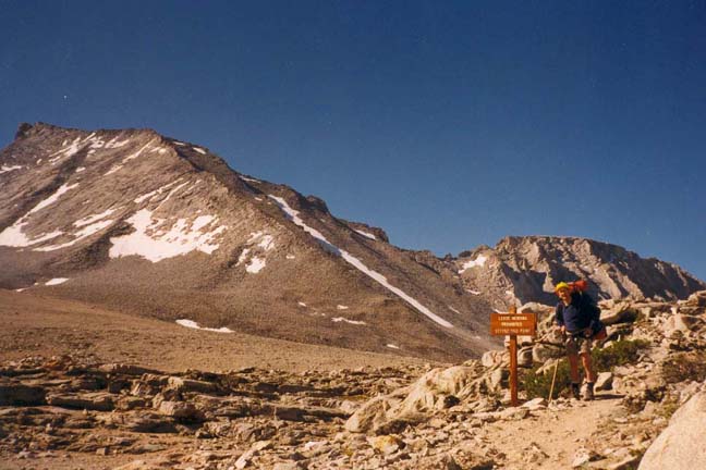
It is an easy walk down the gently sloping trail toward Tyndall Creek. About the 11,400ft level, we left the Shepherd Pass trail and cut across country to meet the John Muir trail at a point some distance north of the junction of the two trails. During this cross-country leg, we rounded the south end of Diamond Mesa and mountains that lay to the west were gradually revealed. First the ridge that projects south from Caltech Peak and then the Peak itself became visible. We lunched beside the Muir trail and selected the equipment that we felt we needed for the climb to the Peak. Then we stowed our packs behind some rocks, and set off north along the Muir trail. Since there is no trail to the summit of Caltech Peak, we were guided by several prominent landmarks. The first of these is the saddle on the ridge just south of the Peak. Also important to identify are the two small lakes in the valley below and east of the saddle. One is about 200ft higher in elevation and a few hundred yards north of the other, the former being slightly north of the saddle and the latter being slightly to the south. These landmarks allow you to identify the only safe route to the top of the Peak when approaching from the east. One way to find these lakes when travelling north on the John Muir trail is to notice a fairly prominent waterfall on the left about 100yds from the trail. Leaving the trail at a point where the elevation is about 12,000ft and climbing the slope to the south of the waterfall brings you to a point midway between the two lakes. From here you should climb straight up the fairly steep and rocky slope toward the top of the ridge, travelling due west. When most of the way to the top of the ridge (and south of the saddle), you can begin to veer north toward the summit. The easiest route is probably to stay to the east of the ridge until past the saddle and then to proceed northwards up a moderate slope to the summit. I should also point out that there is another but somewhat harder route that can be used when the Peak is approached from the west, beginning at Lake South America. Lest I have made the climb seem too difficult, let me hasten to say that as a latecomer to backpacking at nearly 50 years of age, I had little difficulty with the eastern route that required no real climbing but a good deal of scrambling over rocks. Perhaps the only mistake Doug and I made was in not carefully marking our trail on the way up. We had some difficulty retracing our steps on the descent; care needs to be taken in order to avoid difficulties at the lower altitudes where the slopes are very steep.
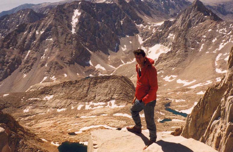
| 
| |
|---|---|---|
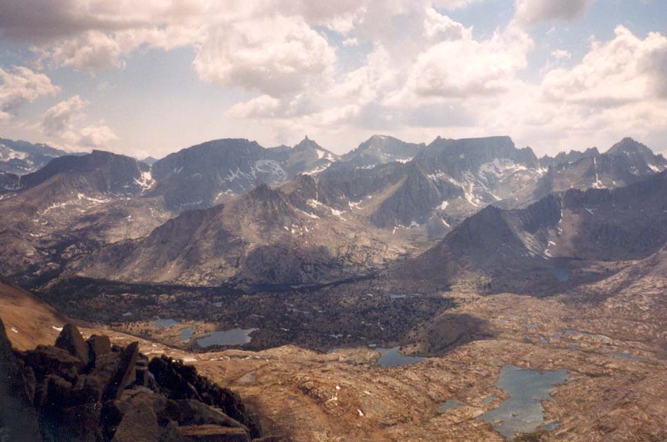
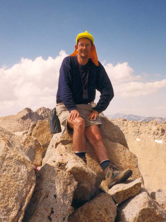
| View west from Caltech Peak | On Caltech Peak |
The climb up from the John Muir trail can be accomplished fairly easily in about two hours, and the reward is a truly magnificient view in all directions. To me it was substantially more interesting than the view we had two days later from the top of Mount Whitney. Looking north along a precipitous and narrow ridge one sees Mount Stanford (inappropriately about 150ft higher than Caltech Peak). To either side of this ridge, the dropoff is almost vertically down more than a thousand feet. To the northeast, massive cliffs stretch from Mt. Stanford to Junction Peak; the John Muir trail makes its way over this obstacle via the dramatic Forester Pass. To the east, the rectangular mass of Diamond Mesa encloses the lakeland below where we began the last part of our climb. Off to the southeast, the view consists of a whole range of 14,000ft peaks including Mount Tyndall, Mount Williamson and, about 15 miles distant, Mount Whitney. Another range of spectacular mountains, the Kaweah Peaks Ridge, frames our view to the southwest with a whole maze of valleys and lakes lying between us and that range. Almost directly below one can recognize Lake South America by its shape. Finally to the west and northwest another range of mountains including Milestone Mountain, Thunder Mountain and Mount Ericsson define the valley beneath us and, as on the east, close in so that passage northwards out of this valley requires negotiation of the precipitous Harrison Pass. It felt as though I had climbed all the way to the sky.
| 
| |
|---|---|---|
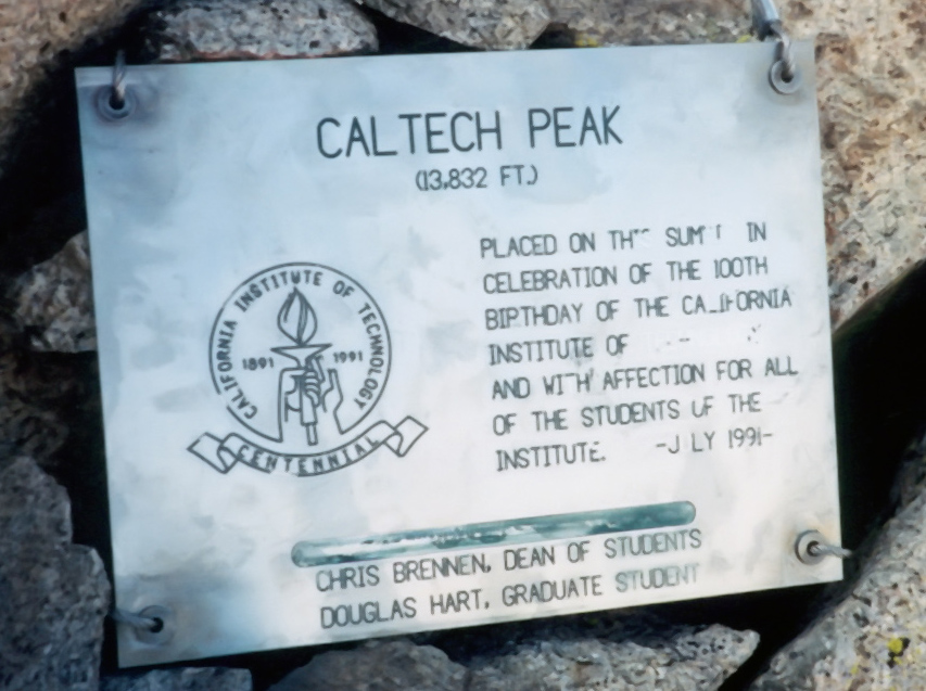
| My entry in the Caltech Peak logbook. | Plaque installed on the CAltech Peak Summit. |
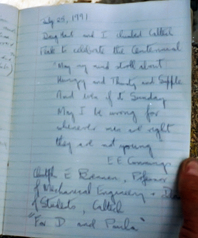
After admiring the view for many, many minutes we began examining the small but interesting cache in the cairn at the summit. This consisted of two metal boxes. One was the conventional Sierra Club model, containing a copy of the brochure ``Facts about Caltech'' (left, I believe, by Bill Schaefer about 1978) and a handsome log book containing the muses of those who had climbed the Peak in the preceding 30 or so years. Doug and I left our own records in this journal. Later we regretted not taking the time to make a list of all of those whose names appeared in this book. But I remember seeing Don Caldwell, the Director of Choral Music, and the names of a number of students and former students, for example Kirk Hazelton. I would estimate that perhaps 40 people had left a record of their ascent in this journal. The other container was clearly a labor of love. Made of aluminium, it had the name Caltech cast into the lid and contained another journal for which the box was custom-made. To this collection of artifacts we added the contribution that we had carried all the way from Pasadena, namely a stainless steel plaque measuring about 15in by 10in with the Caltech Centennial emblem engraved on it along with the following message:
Caltech Peak (13,832 ft.).
Placed on this summit in celebration
of the 100th birthday of the California
Institute of Technology and with affection
for all of the students of the Institute.
July 1991
Chris Brennen, Dean of Students.
Douglas Hart, Graduate Student.
This plaque had been made for us in the Mechanical Engineering Shop by Marty Gould and undergraduate Karen Hong. We affixed it to the rocks on the summit by means of two stainless steel cables using Vise Grips borrowed from Marty.
Finally, since the afternoon was coming rapidly to an end, we reluctantly began our descent. Upon reaching the John Muir trail, we collected our packs and hiked southwards, entering woods at the point where a number of trails converge near the Tyndall Creek camping area. Staying on the Muir trail, we crossed Tyndall Creek and made camp for the night a short distance south of that crossing where there is a row of small lakes just east of the trail. Fortunately, we chose a site further from the water so that the mosquitoes were far fewer in number though not completely absent. I slept soundly after the efforts of the day and awoke refreshed to another glorious morning. After breakfast, we set off southwards along the Muir trail travelling through beautiful, mostly wooded country highlighted by many magnificient views of the surrounding mountains. As we climbed gently toward Bighorn Plateau we looked back for a great view of Caltech Peak from perhaps its best vantage point. For the next seven or eight miles we did not gain or lose much altitude but dropped down into and climbed back out of several most attractive valleys with moderate streams. Here we met and chatted with Len, a schoolteacher from New Jersey who had spent about ten days in the Sierras without any prior experience of backpacking ``just to see if he could survive''. He claimed to have started with far too much gear and food, most of which he had thrown away at the end of the first day. And this included his brand new boots! He had been surviving on oatmeal and peanuts ever since. He was a lively and interesting man with whom we had more conversations while camping that night at Guitar Lake.
At Crabtree Meadow, the Muir trail turns eastward and begins to ascend the valley of Whitney Creek. We had a very pleasant lunch of black bean soup at a pretty spot beside this creek, and even took time out for a siesta. Refreshed, we continued on up this very attractive valley until we reached the picture-book Timberline Lake. Since we were well ahead of schedule, we stopped for about two hours at this beautiful lake. I rested while Douglas tried his hand at fishing. Though he caught several fish, none were large enough to keep for dinner. I spent time studying the massive bulk of Mount Whitney, looming above us, and the almost sheer cliff that extended south from Whitney and which the map said the trail climbed. I could not make out any trail, and still less could I visualize the possibility of any trail surmounting that impressive barrier. Late that afternoon we reluctantly left Timberline Lake behind us, and climbed out of the trees and up to the larger Guitar Lake immediately below the mass of Mount Whitney. Along with a number of others including Len we made camp for the night near the shores of Guitar Lake at an altitude of about 11,450ft.
Anticipating a long day we arose early, breakfasted and started out shortly after sunrise. The trail led through steeper and steeper rock-strewn terrain as it approached the almost vertical wall of rock above us. We then began a series of switchbacks that, despite my disbelief of the previous day, did climb the neccessary 2000ft to the top of the rock wall. There, at an altitude of 13,500ft, our trail met the trail that ascends Mount Whitney from Whitney Portal. Leaving our packs at this junction, known as Trail Crest, we set out to climb the remaining 1000ft to the summit of Mount Whitney. Unlike the rest of our trip, we now seemed surrounded by hikers virtually all of whom were making the pilgrimage from Whitney Portal to the highest point in the contiguous United States. Many had climbed to this altitude too quickly, and were either in considerable discomfort, or had decided to try and sleep it off among the rocks beside the trail. Most were clearly labouring compared with Douglas and I who had the advantage of several days of acclimatization.
| 
| |
|---|---|---|
| Mt. Whitney from Timberline Lake. | Doug on top of Mt. Whitney. |
The trail from Trail Crest to the 14,496ft summit of Mount Whitney proceeds along a ridge, the route having been cut into the cliffs on the western side of the ridge. This part of the trail is quite spectacular. At intervals there are breaks in the ridge that form windows through to the other, eastern side and provide dramatically framed views of Owens Valley some 10,000ft below. The last leg of the climb through a field of rocks seems endless until, suddenly, one surmounts the last rise and there is the summit and the low stone warming-hut built as a refuge against the violent storms that can occur almost without warning on these mountains. Douglas had gone on ahead on this last leg and I was somewhat glad of that for I was quite unable to contain my emotions over that final fifty yards with the summit in full view. Nearly two years before, at a time when I could barely walk I had dreamed of the possibility of being able to climb this mountain. I don't think I ever really believed that it was a physically viable objective. Since that day two years before, I had trained hard and slowly, often disappointingly slowly, I had recovered some semblance of health and begun to establish some reserves of strength. I have never thought of myself as particularly strong, and I had often doubted my ability to endure. I confess that, over those last few yards, tears of pride and accomplishment streamed uncontrollably down my face. It was a feeling I will never forget.
The view east from Mount Whitney is unforgettable. The immensity of the cliffs and the magnitude of the height are overwhelming. It was almost more than the mind could take in. The view from Caltech Peak had seemed kinder perhaps because of its variety. This was enormous and brutal. We took some photographs and signed the register in the shelter of the warming-hut. Then, subdued, we began our descent and collected our packs at Trail Crest. There followed a series of 97 switchbacks down the most immense talus slope. Some distance below that we had a pleasant lunch beside the stream just above Mirror Lake. The last few miles to Whitney Portal seemed endless and our feet were quite sore when we finally arrived at Douglas's car. Driving down toward Lone Pine we found a campground where we enjoyed a wash and a shave in the stream before pressing on to the Symmes Creek trailhead to collect my car. Then back again to Lone Pine where we treated ourselves to a meal in a cafe before the long drive back to Pasadena.
Thus ended a trip whose images and feelings will linger with me forever. They are a kaleidoscope of beautiful scenes from the pages of National Geographic merged with vivid personal emotions of exalted triumph and human fraility. Though I was to climb many peaks in distant corners of the earth in the years that followed, Caltech Peak and Mount Whitney represent a defining moment in my life and thus retain a special place in my affections and my chronicles.
Last updated 7/30/99.
Christopher E. Brennen