ADVENTURE HIKES AND CANYONEERING
IN THE SAN GABRIELS
© Christopher Earls Brennen

|
|---|

|
Hike D17. Wolfskill Canyon
- Hiking time: 8 hours
- Estimated hiking distance: 7.7 miles
- Elevation gain: 1930 feet
- USGS Topo Maps: Mt. Baldy, Glendora
- Difficulties: One large, waterfall rappel (100ft), one smaller rappel, some steep firebreak hiking, a little bushwhacking
- Special equipment: Rappelling gear, 150ft rope and recovery cord
-
ACA Rating: 3A III

Characteristics
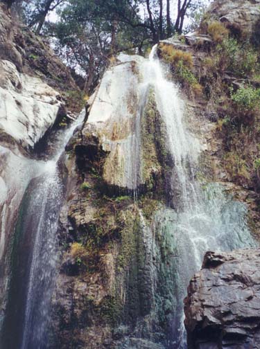
In my opinion, Wolfskill Falls are one of the prettiest and most spectacular waterfalls in the San Gabriel mountains. In the spring when they run more fully, the multiple strands cascading down the 100ft crag provide a spectacle well worth the hike up San Dimas and Wolfskill Canyons. This adventure, best undertaken in the summer or fall, climbs over the ridge separating the route of Wolfskill Creek from the San Gabriel Valley and then descends Wolfskill Canyon to emerge into San Dimas Canyon. In the process, it involves a dramatic rappel descent of those falls and a transit through this beautiful wooded canyon.
Trailhead
This hike requires a car shuttle. From Foothill Boulevard in the city of San Dimas turn north on San Dimas Canyon Road and drive 1.9mi northeast to the stop sign at the intersection with Golden Hills Road. You will go east on Golden Hills Road once you have deposited the return vehicle. To do this continue north on San Dimas Canyon Road for another 2.1mi. The road climbs past the San Dimas Canyon Dam and proceeds around the east side of the reservoir to the locked gate at the end of the road (just past the fire station). Park the return vehicle here on the west side of the road (34o9.98'N 117o46.11'W and elevation 1580ft).
Then, in the other vehicle, drive back down San Dimas Canyon Road and turn left on Golden Hills Road. Drive 1.2mi to a stop sign where you turn left on Stephens Ranch Road. Drive north 0.6mi to a point just north of the Marshall Canyon Golf Course and 50yds south of the dirt road entrance to Stephens Ranch on the left. Here you should be able to see a broad firebreak trail climbing the hillside to your left. Turn around and park on the broad shoulder at the side of the road where this trail heads up the mountain (34o9.14'N 117o44.94'W and elevation 1840ft).
Hike
The firebreak trail climbs steeply from an elevation of 1840ft all the way to the Sunset Ridge fireroad at 3350ft over a distance of just under one mile. Though steep it is broad and easy to follow and you should reach the road (at 34o9.91'N 117o45.03'W and elevation 3350ft) about 1hr 30min from the start. At the top, turn right and follow the road that gently climbs and descends several times over the next couple of miles. It is smooth and easy hiking. After about 1.5mi you will pass fire hydrant box UW7 on your left. Continuing along the road, it switchbacks to the west for about 300yds and then swtiches back east. About 200yds beyond this second corner look for a flat section with a broad array of bushes and a gentle descent to the north. This is the drop in point at 34o10.20'N 117o43.10'W and an elevation of 3770ft, 2.5mi from the point where you joined the Sunset Ridge Road. You should reach this point about 2.5hr from the start of the hike.
 | 
| |
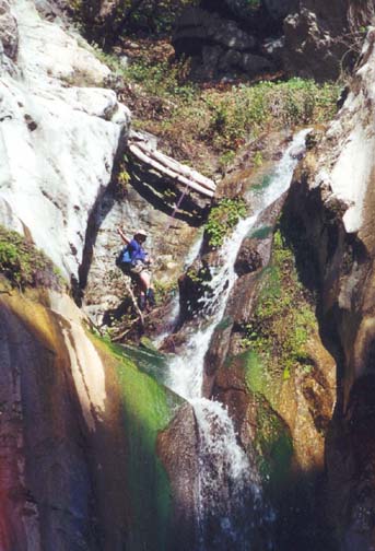
|---|---|---|
| Wolfskill Falls | Descending the Falls |
At the drop-in point there is no obvious gully descending north. Find a slight low point and locate an animal trail into the bushes. It should be close to several lone conifers that protrude above the bushes. Follow the slight animal trails in places and bushwhack in others as you progress down slope in a generally northerly direction. Though some bushwhacking is needed, you should soon find a small and relatively brush-free gully that allows easier progress. Following the gully and descending about 450ft, you will arrive in the bottom of Wolfskill Canyon (34o10.33'N 117o43.17'W and elevation 3330ft) about 30min from the drop-in point and 3hr from the start. A small stream flows here throughout most of the year.
Apart from the few obstacles noted below, Wolfskill Canyon is quite easy going. It is a generally open, wooded canyon with relatively little brush. Near the big falls, you will encounter a number of sections with brambles but these are fairly easily negotiated. Leather gloves and a stick are useful there. Notable waypoints in the upper part are a small, easily negotiated chute at 2950ft that you should encounter after about 30min of downcanyon travel, a large creek that comes in on the right about 15min later and a downclimb of a 10ft cascade (elevation 2700ft) that is necessary after about 65min of canyon hiking.
About 1hr 15min after reaching the canyon bottom and 4hr 15min from the start of the hike, you arrive at the top of the first major obstacle at an elevation of 2690ft. It is a three stage waterfall in a narrow slot. There is no convenient anchor other than the large and strangely distorted tree that bridges the slot high above the lip. To reach this tree and use it as the rappel anchor you need to back up, climb the dirt slope on the right and then descend to the tree down a steep slope. From this tree It is a 50ft rappel to the shallow pool at the bottom of the third cascade. Beyond this obstacle the easy going resumes and between here and the big falls there is only one minor problem, namely an awkward 6ft waterfall at 2210ft that needs careful climbing around to the right.
Finally, at an elevation of 2040ft, about 6.5hr after the start of the hike and about 2mi downstream from where you accessed Wolfskill Canyon, you will arrive at the top of the spectacular 100ft Wolfskill Falls. Multiple streams crash off protruding rocks and shoot down slots to the bottom of this awesome waterfall. Vertical cliffs surround the chasm into which the stream descends. The 100ft descent requires a single strand rappel so you should prepare the recovery cord for use. There are three possible routes of descent, on the left, in the center and on the right. On the left, the descent is dry but brushy; the tree anchor is some distance back from lip so rope retrieval might be difficult. In the center there are several large trees any of which would make a good anchor; but the descent involves rapelling in the water all the way down. Instead we chose a route on the right using a smaller tree off by the right wall as the anchor. This route is dry for first 40ft but wet thereafter as you descend a spray and water filled groove.
At the bottom of Wolfskill Falls, the technical gear can be stowed since there is at least a rough trail the rest of the way. First you bypass a 40ft vertical waterfall by means of a trail around to the left. At the bottom, the trail crosses to the right side to bypass another modest waterfall in a fern-filled recess. Just beyond this you pass the first, abandoned cabin. Then, about 15min below the big falls at 1700ft, you come to the end of Wolfskill Canyon where it merges with San Dimas Canyon. The latter comes in from the right through a gap with rock walls on both sides. Downstream from there, you follow the dirt road past many cabins. The road fords the stream in many places where it is difficult to avoid wading. Finally, 2mi and 45min below Wolfskill Falls, you come to the San Dimas Canyon entrance gate (34o9.98'N 117o46.11'W and elevation 1580ft) where you parked the return vehicle.
Last updated 3/28/01.
Christopher E. Brennen