ADVENTURE HIKES AND CANYONEERING
IN THE SAN GABRIELS
© Christopher Earls Brennen

|
|---|

|
Hike F2. Upper Soldier Creek
- Hiking time: 4.5 hours
- Estimated hiking distance: 3.4 miles
- Elevation gain: 1130 feet
- USGS Topo Maps: Crystal Lake
- Difficulties: One large 120ft rappel, three small rappels, some downclimbing and much bouldering.
- Special equipment: 200ft rope, 150ft recovery cord, rappelling equipment, 20ft webbing and two rappel rings
-
ACA Rating: 3A II

Characteristics
Soldier Creek is a beautiful, rugged canyon high in the San Gabriel mountains that offers two marvellous adventure hikes. The lower section is quite easy and is described elsewhere in this book. This upper section is quite dry and a moderately challenging adventure hike with one large rappel and several smaller ones. It is good for anytime from late spring to the fall but may be quite cold in winter.
Trailhead
The hike is best done with a car shuttle, otherwise you will have to walk an additional 2.6mi up the road through the Crystal Lake complex to get back to your car. Drive up Highway 39 from Azuza along the north fork of the San Gabriel river, past Colbrook and Falling Springs to the junction of Highway 39 and the turn-off to Crystal Lake. Just about 100yds before that turn-off there is a closed metal gate on the outside of a long left-hand curve. Turn around at the turn-off and drive back down the road, past the gate to the first pullout on the left past the no parking signs. Leave one vehicle there (34o18.78'N 117o50.04'W and elevation 5000ft) and then turn around again and proceed up to the Crystal Lake area. You may have to pay $5 to enter the Crystal Lake campground area. Then proceed up through the campground, veering left as you pass the visitor center. Just beyond the sign that warns of the end of the pavement there is a large, partly dirt parking area (34o19.65'N 117o49.98'W and elevation 5810ft). Park there.
Hike
The Windy Gap trail starts just to the left of an iron gate on the right or upper side of the large parking area (34o19.65'N 117o49.98'W and elevation 5810ft). The hike begins by following this well-maintained trail as it climbs the northern side of the Crystal Lake bowl. After about 15min it crosses the asphalt road leading to Deer Flats (34o19.88'N 117o49.99'W and elevation 6000ft) and another 15min brings you to the dirt road (34o20.15'N 117o49.76'W and elevation 6490ft) headed to the right for South Mount Hawkins. The Windy Gap trail continues on the other side of this road but you follow the road as it climbs around to the right along the east side of the bowl. It is a very pleasant walk with many good views not only of the Crystal Lake area below you but also of the San Gabriel Mountains to the west. Mount Wilson is readily visible and you should be able to make out Catalina Island far to the southwest.
|
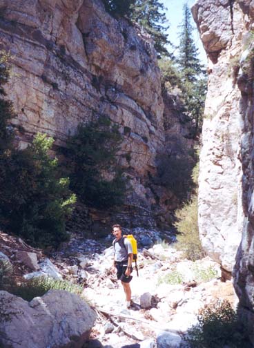
|---|
| Lower section of Upper Soldier Creek |
Follow the South Mount Hawkins fire road for about a mile as it crosses two steep, rockfilled gullies and approaches the Soldier Creek crossing. This is most readily identified by looking for the place where the dirt road splits to bypass a lone pine tree in the middle of the road. Just after that the road rounds a headland with some great views and then begins to contour into Soldier Creek canyon. The drop-in point (34o19.37'N 117o49.20'W and elevation 6940ft) is where the road crosses the streambed and you should reach this point 1hr 10min (and 2.2mi) from the start. From here you should be able to discern far below you the long curve of Highway 39 where you left the first vehicle.
The initial descent is steep and rocky but there are several delightful little springs with cool, clean water to refresh yourself on a hot day. About 400ft and 25min from the drop-in point you encounter the first significant obstacle, a small 15ft waterfall that can be downclimbed on either side though care is needed. Immediately below this you come to the first rappel, a straightforward 25ft descent using the tree anchor a short scramble above you on the left. This dryfall can also be downclimbed via a slot on the right but I recommend the safer rappel. Below this rappel it is a short way to another short downclimb, the easiest route being in the center. You should reach this point (elevation roughly 6300ft) about 2hr from the start.
Below this, the canyon levels out somewhat and there is a long section of moderately easy scrambling before you quite suddenly find yourself, at an elevation of 5750ft and 2hr 50min from the start, standing on the lip of the largest drop-off in this adventure. The stream bed drops about 120ft from a broad lip of hard white granite to an open boulder field below. There are two ways to rappel down this obstacle. You can choose the route on the left and, anchoring to the roots of a large bush, descend about 80ft to a side gully from which the main channel is easily accessed. We chose the alternative, a 120ft rappel down the main channel, anchored by the roots of another large bush on the right side of the lip. Watch out for loose, falling rock on both routes.
Just about 100yds below the big rappel you enter a very pretty, narrow section with vertical cliffs walls and some welcome shade on a hot day. This leads to the last two rappels. The first is a 30ft drop down through a rocky slot, anchored by the group of trees at the lip. You can if you wish downclimb the first 10ft or so to a shelf where the rappel entry is easier. A few yards later you come to the last rappel, a small 15ft drop around a large chockstone. Some may choose to downclimb this by chimneying the slot on the left but a rappel is recommended. The anchor is a large tree trunk just above the lip. You should reach this point (elevation 5380ft) about 4hr from the start. There follows a steep section of bouldering and downclimbing before the canyon suddenly opens up into a relatively flat and broad, wooded boulder field with many branching and dry stream channels. Stay to the right, within sight of right wall. Soon you emerge onto a flat open meadow and pick up an old dirt road that leads back to the gate beside the road and the end of the hike (34o18.78'N 117o50.04'W and elevation 5000ft). It should take a total of 4.5hrs.
Extension to Lower Soldier Creek
Clearly it is possible to combine the Upper and Lower Soldier Creek
hikes to create an all-day adventure of about 6.5hrs. The
combination is particularly sweet because of the contrast between
the rocky, open and dry upper section and the lush, shaded
lower section with its lovely stream.
Last updated 7/30/00.
Christopher E. Brennen