ADVENTURE HIKES AND CANYONEERING
IN THE SAN GABRIELS
© Christopher Earls Brennen

|
|---|

|
Hike F5. Upper Little Rock Creek
- Hiking time: 4 hours
- Estimated hiking distance: 4.5 miles
- Elevation gain: 1100 feet
- USGS Topo Maps: Waterman Mountain, Crystal Lake
- Difficulties: A little boulder climbing
- Special equipment: None
-
ACA Rating: 2A II

Characteristics
One of the most popular rock climbing areas in the San Gabriel Mountains is a large rock just to the west of Mount Williamson on the north side of Little Rock Creek. This hike follows Upper Little Rock Creek down past this rock face and through its transition from a rock-ribbed gorge to a verdant and gentle valley. This is a relatively easy adventure hike that includes a modest climbing challenge not long after the start. It is ideal for a hot summer day when the temperature is significantly cooler than in the basin below.
Trailhead
The trailhead (34o21.71'N 117o52.22'W and elevation 6610ft) is a large parking area on the north side of the Angeles Crest highway just to the west of Mount Williamson. It is about 38mi east of La Canada Flintridge, 2.4mi east of the Snowcrest Ski area and about 0.25mi west of the highway tunnels through the side of Mount Williamson. If you drive up the Angeles Crest Highway from La Canada Flintridge and come to the tunnels then you should backtrack to the first large parking area on the north side of the road.
In order to eliminate a four mile hike back along the Angeles Crest Highway at the end of the day you may wish to set up a car shuttle by leaving a vehicle at the Burkhart Trailhead (34o20.84'N 117o54.75'W and elevation 6450ft) adjacent to the Buckhorn campground before driving to the starting point. To do this when driving east take the turn-off to Buckhorn campground just 0.25mi east of the Mount Waterman Ski Lift. The narrow, one-way road winds down to the center of the campground. From here, there are signs to the Burkhart Trailhead parking area about 0.2mi north of the campground. After leaving this return vehicle, drive back to the campground and again locate the one-way road that takes you back to the Angeles Crest Highway. Drive about 4mi east on the highway to the previously described starting point.
Hike
Two trails begin at the dirt parking area in the lee of Mount Williamson. One climbs up to the summit of Mount Williamson; the other, the one we want, descends into the canyon of Upper Little Rock Creek. The latter follows what used to be a dirt road, the access to an old dam and pumphouse in this canyon. On the descent you will encounter one fork at the head of a gully where you should continue along a slightly rising dirt road rather than follow the canyon bottom. Soon the road vanishes and the trail descends to the floor of the canyon. Travelling downstream you soon come upon a rocky section where you must clamber and bushwhack a short distance. However, very soon (about 35min from the start) you arrive at the base of the great rock cliff (base elevation 6240ft) that is so popular with climbers. You may wish to stop to watch them scale the walls of the gorge. Many of the climbing routes can be traced by eye by observing the trail of metal bolts winding up the rockface.
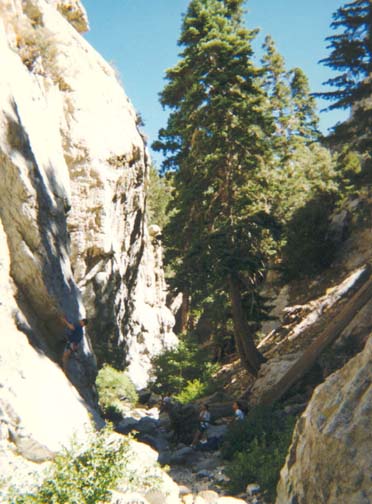
|
|---|
| Climbers in Upper Little Rock |
Moving on down the canyon, there are several large boulder obstacles to negotiate before you come to a short section, several hundred yards from the cliff and 70min from the start, where a little special effort is needed. First the stream falls down through a small rock-sculpted gully with a ledge on the right hand side. It is a little tricky to transition from one of the ledges to a larger flat shelf about 5ft below. The first person down can greatly aid the others in this descent. The second section is easily overcome if you take note of a small ledge that climbs about 10ft to a trail that bypasses the small waterfall. Once past these obstacles, it is but 100yds to the place where the Eagle's Roost Trail crosses the canyon bottom. This trail crossing at 34o21.55'N 117o52.84'W and an elevation of 6060ft is about 0.8mi and 1hr 20min from the start.
At this point where the trail crosses the stream, there are three alternative hikes that are possible. If you have had enough at this point you may wish to take the trail to the left up to Eagle's Roost on the Angeles Crest Highway. This maintained trail reaches the road after a climb of about 650ft over about a mile. You can then walk about 0.8mi back along the road to the point where you started. The second alternative is to take the same trail up the other side of the canyon. This is the maintained Rattlesnake Trail that first climbs up the north side of the canyon, then contours along a route travelling downstream below the ridge, finally descending to the canyon bottom again and meeting the Burkhart trail just a few yards before a second stream crossing where you will connect again with the third alternative. From trail crossing to trail crossing, it is about 2.5mi by the Rattlesnake Trail.
The third, or off-trail, alternative is to continue on down the canyon from the first trail crossing. In contrast to the first part of the hike this section is generally wooded and gentle with many fish-filled pools. After about 25min, you will come to a place where the stream has carved a convoluted path through the rock and then drops a few feet into a large pool. This makes a pleasant lunch stop and a great place to bathe. We used the rope attached to a tree overhead to ``drop in''.
As you continue downstream you will encounter a few places where ready progress is blocked by brush and you must bushwhack your way through. About 30min from the first trail crossing you will pass a place where there is a good campsite under a stand of cedar. Downstream it takes another 1hr 30min before you reach the place where the Burkhart Trail crosses the canyon bottom. Several hundred yards before this you should be able to discern the Rattlesnake Trail gradually descending the north or right side of the canyon. The Burkhart Trail crossing is at 34o21.76'N 117o53.98'W and an elevation of 5690ft. The total hiking time from the start to this point is about 3hr 30min during which you have travelled about 2.4mi.
The rest of the hike consists of following the Burkhart Trail back up
to the Buckhorn trailhead. About 0.25mi beyond the stream crossing you
reach a fork
(34o21.63'N 117o54.18'W,
elevation 5810ft) where the Burkhart trail goes to the left; the right
branch is the trail up Cooper Canyon. Take the left fork, the Burkhart trail.
This last section on a well-travelled trail
provides a most pleasant and attractive hike
that starts in the deep woods at the junction where
Little Rock Creek and Cooper Canyon come together.
It climbs up to the sparser pine woods typical of the slopes
on the northern slopes of the San Gabriels. The hiking distance from
the canyon crossing (elevation 5610ft)
to the Buckhorn trailhead
(34o20.84'N 117o54.78'W,
elevation 6450ft) is about 2mi and it can be covered in
about 50min.
Last updated 7/30/99.
Christopher E. Brennen