ADVENTURE HIKES AND CANYONEERING
IN THE SAN GABRIELS
© Christopher Earls Brennen

|
|---|

|
Hike H3. Upper Cucamonga Canyon
- Hiking time: 13.5 hours
- Estimated hiking distance: 9.1 miles
- Elevation gain: 2800 feet
- USGS Topo Maps: Cucamonga Peak, Mt. Baldy
- Difficulties: Four rappels, ranging in height from 15ft to 80ft, much bushwhacking
- Special equipment: Rapelling equipment with a 160ft rope, a 120ft rope, 60ft of webbing, 4 rappel rings and dry bags.
-
ACA Rating: 3A IV

Characteristics
Cucamonga canyon is the main watercourse that drains the precipitous south face of the Bighorn/Ontario ridge, a prominance that includes Ontario Peak and Bighorn Peak. In another chapter, we describe a easy adventure hike that explores the relatively benign lower section of this wild and rugged canyon. The present hike follows the entire upper course of Cucamonga Canyon from its origin at a saddle behind Cucamonga Peak, down through several vegetation zones and two narrows to finish where that earlier hike began. It is a strenuous, two day adventure hike with some spectacular scenery and several challenging rappels. It is best undertaken during the summer or early fall when the river is not swollen with run-off. It becomes much more challenging when the snow comes to the high country.
Trailhead
The hike requires a car shuttle, for which one four wheel drive vehicle must be stored at the end of a rough dirt road that accesses the bottom section of Cucamonga Canyon. To get there from the west drive east on Foothill Boulevard to Euclid Avenue in the city of Upland. Turn north and, some distance up Euclid, turn right onto 19th Street and then left (north) on Sapphire. At the northern end of Sapphire, turn left on Almond and then immediately right on Skyline. Skyline rapidly narrows to a single lane as it climbs into Cucamonga Canyon. There is a small parking area where the asphalt ends and the dirt road begins. The dirt road continues to climb for about 0.3mi at which point the road forks. Take the left fork that descends again toward the canyon bottom and crosses the river at a concrete ford just before a large clearing that is the final destination of this hike. There are many places to park here (34o10.86'N 117o37.80'W, elevation 2680ft).
Having deposited the return vehicle, you then proceed back down Sapphire and west along 19th Street to Euclid. Now, however, you turn right (north) and proceed up Euclid to the intersection with 24th Street. Here you jog left and follow the signs for Mount Baldy along the winding road toward the northwest. This becomes Mountain Avenue and enters San Antonio Canyon where it joins the main Mount Baldy Road just beyond a Ranger Station. Drive on up the Mount Baldy Road in San Antonio Canyon to the parking area for Icehouse Canyon (34o15.00'N 117o38.11'W, elevation 4990ft), 1.5mi north of Mount Baldy Village. The access road to this parking area proceeds straight on at a fork where the road continuing up to the ski lift makes a sharp left turn.
Hike
From the parking area (34o15.00'N 117o38.11'W, elevation 4990ft), proceed up the well-marked Icehouse Canyon trail that parallels a sparkling, year-long stream. There are many cabins in the first mile or so, and also ruins of cabins that were destroyed in a flash flood in 1938. The main trail has mile markers. The cabins and incense cedars soon disappear and you enter the Cucamonga Wilderness as the landscape becomes more rugged and open. The trail steepens as it switchbacks up the north slope of the canyon and 3.5mi and 2hr from the start you finally reach Icehouse Saddle at 34o14.35'N 117o35.66'W and an elevation of 7550ft. Several trails come together at this point but you need to identify the trail to Cucamonga Peak. This proceeds along the right hand slope on the other side of the saddle. It soon forks and you must take the right fork that reaches Cucamonga Sadddle (34o13.75'N 117o35.49'W, elevation 7654ft) about 2hrs 45min from the start.
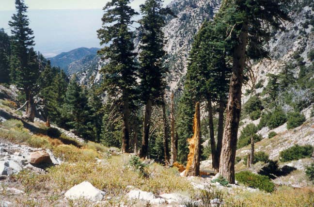 | 
| |
|---|---|---|
| High in Cucamonga Canyon | Big falls in Cucamonga Canyon |
The entry to the Cucamonga canyon from the saddle is moderately steep but broad and open. Mostly scree with scattered pine trees, it is quite easy going and the wide canyon allows spectacular views of the southern cliffs of the Ontario/Bighorn ridge. As you lose elevation, the trees increase and, for a brief spell, the footing remains fairly easy though the canyon begins to narrow. At an elevation of about 5700ft several large side canyons enter from the north and, shortly thereafter, about 2hrs 15min from Cucamonga Saddle (5hrs from the start), the the canyon makes an S-bend and suddenly narrows. This narrowing has two consequences. First, the going becomes significantly slower with small waterfalls and many boulders to negotiate. But, as if to compensate, this is also where you will encounter running water for the first time, at least in the dry summer months. Both consequences result from the same increase in the hardness and imperviousness of the rock.
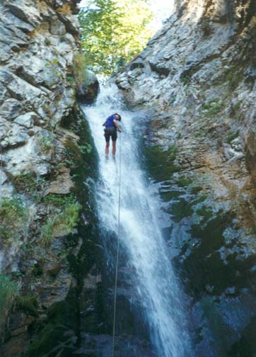
About 2hrs downstream of the S-bend (or 7hrs 30min from the start), the canyon deepens again and you enter the Upper Narrows, the most dramatic gorge in Cucamonga Canyon. With the steepening walls, you begin to anticipate larger and more precipitous waterfalls and, at about 4600ft, the first substantial obstacle you encounter is a small, 15ft waterfall. This milestone is readily identifiable because you can climb down through a slot to the right of the falls. Shortly after this there is a slide that is negotiated using a log that runs through it. This is immediately followed, at an elevation of about 4500ft, by the largest waterfall of the adventure, the Upper Cucamonga Falls with a vertical drop of about 65ft to a large pool in a deep, flat-bottomed ravine. The good news is that there are excellent anchors in the form of trees near the lip and the entry is relatively easy. The bad news (good on a hot day with low stream flow) is that, for the first half of the descent, there is no alternative but to rappel down in the waterfall itself. Further down you can veer to your left and out of the stream. However, the pool at the bottom was waist deep when we passed this way.
The Upper Narrows continue downstream of the big falls. A large tributary enters from the north via a waterfall that is usually dry in the summer. About a hundred yards further on (about 8hrs 15min from the start) you come to the second of the two rappels in the Upper Narrows, a small vertical drop of about 20ft into a waist deep pool. Again there are several trees that provide anchors, Though it is difficult to avoid descending in the water, this is a straightforward rappel.
Judging by the lack of signs of human passage above these falls, they represent the furthest penetration made by hikers coming from below since, though small, they would be very difficult to ascend. Downstream there are several places that would be comfortable for an overnight camp. Two of these have the remains of rock-ring fireplaces constructed by previous adventurers. One of these is a short distance downstream of the second rappel at a point where the Upper Narrows end and the canyon broadens somewhat.
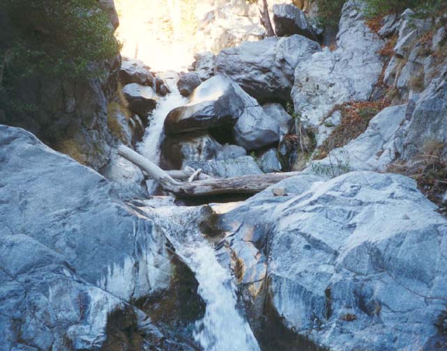
|
|---|
| In the Lower Narrows |
It is about another 1hr 30min to the start of the short but
steep and rugged Lower Narrows
(34o11.84'N 117o36.92'W,
elevation 3860ft). They begin
with two broad 25ft waterfalls, both formed by the
accummulation of large boulders. The first of these is readily climbed
on the left.
The second could also be climbed via a damp earth and rock slope round
to the left but it is safer and easier to rappel down using as your anchor
the large tree in the left center.
Below this point the Cucamonga Creek crashes over a
series of cascades as it makes its way through a very rugged
gorge. Almost immediately there are several small waterfalls
that are awkward to negotiate.
A short distance downstream you come to the Lower Cucamonga falls (34o11.83'N 117o36.99'W, elevation 3790ft), a 50ft vertical drop through a narrow cleft into a small, dark pool. A horizontal log spans the canyon a short distance upstream of the falls and this could be used as an anchor. But it is easier to follow the well-travelled route around to the left of the waterfall. To do so find the trail up the dirt slope a short distance upstream of the lip. This leads to a narrow ledge and then to the spine of a ridge that projects out into the canyon above and to the left of the falls. A tree just below and to the right of the spine provides an excellent anchor for the rappel down the left side of the ridge along a well-worn climbing route. It is about a 90ft descent down quite irregular terrain with some overhang. Several old ropes hang down along the rappel route and I strongly recommend that you place no reliance on these. The rappel ends at the top of an earthy slope among trees in an area just around the corner from the Lower Cucamonga falls. This point should be reached about 11hrs 30min from the start.
Downstream from the bottom of this last rappel at an elevation of about 3700ft, there is short, rugged section before the canyon walls diminish and, about 15min from the falls, the main canyon widens to form a large and interesting boulder field, about 0.5mi long. Note that there is a well-used and sheltered campsite in a grove of trees on the left just before the boulder field and, just beyond this on the right, is a pretty waterfall where a tributary canyon drops into the main canyon from the left. This smaller canyon seems to drop straight down from the precipitous south face of Ontario Peak.
To negotiate the boulder field stay on the left initially but transfer
to the use-trail on the right below the rocky promontory that
juts out into the boulder field on the left.
It is only
about 1.5mi (1hrs 30min) from the end of the boulder field
to the parking area where you left the return vehicle. Along
the way you will encounter several beautiful pools with fish.
Roughly 40min below the boulder field, there is a particularly
attractive pool that makes for a delightful summer swim.
The hiking along this stretch is relatively undemanding though there are
many stream crossings. A use-trail becomes more evident as you
get closer to the end. The canyon
is narrowest during the very last section and, just before the end,
you encounter a canyon-spanning pool that requires wading.
It is shallowest (about 3ft deep)
along the right wall. A short distance south of this pool you reach
the parking area where you left the return vehicle
(34o10.86'N 117o37.80'W,
elevation 2680ft).
The total hiking time from the start is about 13.5hrs.
Last updated 7/30/99.
Christopher E. Brennen