ADVENTURE HIKES AND CANYONEERING
IN THE SAN GABRIELS
© Christopher Earls Brennen

|
|---|

|
Hike B20. Upper Big Tujunga
- Hiking time: 5 hours
- Estimated hiking distance: 2.8 miles
- Elevation gain: 500 feet
- USGS Topo Maps: Condor Peak, Chilao Flat
- Difficulties: Some climbing, route finding and wading
- Special equipment: Wading gear
-
ACA Rating: 2B II

Characteristics
Between the Big Tujunga Road Bridge and Colby Camp, Upper Big Tujunga Canyon winds through a pleasant gorge that provides a straightforward adventure hike with some moderate challenges. It is particularly enjoyable in summer since the river flows year round and there are a number of swimming pools along the way. The hike involves much boulder-hopping, some wading, one climb that is a little airy and several other climbs around small falls. No ropes or technical equipment are needed.
Trailhead
This hike requires a car shuttle or the placement of a bicycle with which to ease the return by road. The main trailhead is a dirt parking area (at 34o18.41'N 118o8.76'W and elevation 2940ft) on the east side of the road, 0.4mi south of Big Tujunga Road Bridge on the Angeles Forest Highway. It is most readily recognized by the large tree in the center of the parking area and confirmed by the presence of a trailhead on the other side of the road. But before parking here drive further north on the Angeles Forest Highway, across the Road Bridge and about 2.5mi further north to the road junction where the Upper Big Tujunga Road meets the Angeles Forest Highway. Turn right onto the Upper Big Tujunga Road and drive about another mile. Turn right onto the narrow paved road to Colby Camp. About 0.5mi down this road is a narrow metal bridge (at 34o18.59'N 118o6.81'W and elevation 3150ft) over the river where we shall later leave the canyon. Park the second vehicle in the lot just on the other side of the bridge (or leave the bicycle somewhere nearby).
Hike
Back at the dirt parking area just south of the Big Tujunga Road Bridge (34o18.41'N 118o8.76'W), cross the highway and start down a well-trodden trail that descends into Big Tujunga Canyon. About 100ft above the river, this trail rapidly disintegrates. If you follow the trail to its end, you find yourself at the top of a steep cliff above and around a concrete gauging station. It is not a good idea to try and descend here. Rather, retrace your steps about 20yds to where there is a steep but less dangerous place to climb down the remaining 100ft or so. There are several trees and root systems that provide valuable hand and foot holds.
 | 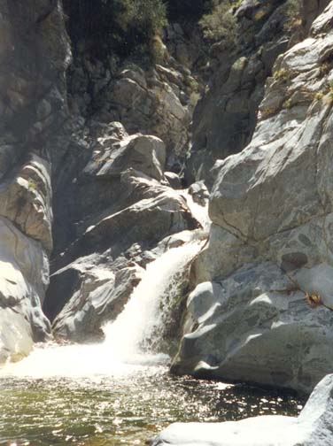
| |
|---|---|---|
| First falls | Upper Tujunga Falls |
At the bottom (elevation 2640ft), turn right and start hiking upstream. It is rough but fairly easy going here though you must cross the river in several places and this is harder to do when the water is higher.
You will encounter a number of automobile remains and other artifacts presumably thrown into the canyon from the road and bridge above. After 25min you arrive at the junction of Mill Creek and the Big Tujunga. Stay right in the Big Tujunga and 45min from the start you pass under the Big Tujunga Road Bridge whose arches are high above you. Indeed, you may be watched from above as you make your way upstream. The going remains fairly easy in this pleasantly wooded section of the canyon. In many places there is a use-trail that helps speed progress up the canyon. About 80min from the start a large canyon enters from the right and just upstream of this junction the canyon broadens and the bottom becomes quite flat with a number of meadows. There are several pleasant picnic sites here and you may spot a deer or two.
About 1hr 40min from the start the canyon closes in again and at 2hr you arrive at a section of narrows. The first substantial falls cascade down about 20ft into a pool-filled rock cavity. Ascend a cleft immediately to the left of the falls, a quite straightforward climb. After another brief section of bouldering, a much more impressive obstacle comes into sight, 2hr 25min from the start. The river crashes down through a a steep and narrow defile with polished rock walls and then plunges over a 30ft waterfall into a large pool, almost a small lake. These are the largest falls in the upper section of the Big Tujunga Narrows. There is a broad area around the lake with a very pleasant, sandy beach. It is a beautiful place for lunch and a swim on a summer day. It is not immediately obvious how to get above this waterfall or series of waterfalls. There are, in fact, two routes, one quite straightforward, the other very difficult indeed. The cliffs immediately around falls are clearly only for the experienced rock climber. Instead, the route for most hikers lies up the somewhat airy use-trail that climbs the steep bank to the left of the falls. This is easier than it looks from below. You follow it by first ascending the gully to the left of the steep bank. A short distance up you should be able to discern a use-trail traversing back to the right across the steep bank. Follow this use trail across and up to the sharp ridge about 150ft above the river. This point is easily identified since, from it, you can look straight down on the river above the falls. The descent from here looks difficult but there is a well worn trail that is quite easy. To reach it you walk a few yards up the ridge until you can see clear signs of the use-trail descending; climb down about 6ft and then traverse to your left about 5yds between a rock and a bush. From here the trail goes straight down about 60ft; if it is not well worn then you should back track and look again for the trail. You descend onto a rock shelf a few feet above the river and, from here, the route upstream is clear.
But, before proceeding upstream, you may wish to clamber a few yards downstream to inspect the falls from above. You cannot, in fact, get very close to the main falls without climbing but you should be able to discern the upper part of the difficult climbing route up through this gorge. It lies along a ledge that climbs the south wall of the canyon to a height of about 50ft and then descends to a shelf right in the apex of the defile. You cannot see more from above but, from below the falls, you may have noticed a large slot about 6ft wide that cuts deeply into the cliff to the right of the falls. The rock climbing route through the gorge is to get into this slot (you may have to swim through the pool to get there) and then climb about 40ft up the rock at the end of the slot to the afore-mentioned shelf. There is an old rope hanging in this slot but it is very unwise to trust such ropes; there are, incidentally, a number of other such ropes hanging at various points within the gorge. But, I strongly recommend against any climbing in this defile unless you are an experienced rock climber.
Proceeding upstream from above the falls, the canyon is quite rocky for the rest of the way and there are several places where wading is not easily avoided. There is no difficult climbing but there are a number of places where the route requires some thought and a little scrambling. It is slow going over this stretch and harder in the winter when the water is colder and deeper. There are some beautiful pools that are much more fun on a hot summer day and positively invite you to swim.
When you are almost at the end of the hike, there
is one 15ft cascade that discharges
into a rocky pool. Often groups of young people hike down to this
point from above and enjoy jumping into the pool beneath this
waterfall. From downstream, you
approach this cascade on the left of the canyon, climb
down to the river, cross it and then ascend to the right of the falls.
This would be a very pretty spot except that it
has been despoiled by vandals who have spray-painted the rocks in many places
and have left substantial litter. I traversed this section with a heavy heart.
Above the cascade there is a short wooded
section before you encounter the Colby Canyon bridge at
34o18.59'N 118o6.81'W and
an elevation of 3150ft. Climbing the bank on
the right side brings you to the parking area where you left the second
vehicle or bicycle. It takes about 2hr to complete this upper half of
the hike from the main falls to Colby Canyon bridge.
Last updated 7/30/99.
Christopher E. Brennen