ADVENTURE HIKES AND CANYONEERING
IN THE SAN GABRIELS
© Christopher Earls Brennen

|
|---|

|
Hike K2. Sutton Canyon
- Hiking time: 6.5 hours
- Estimated hiking distance: 5.3 miles
- Elevation gain: 2285 feet
- USGS Topo Maps: Sunland, Condor Peak, Pasadena
- Difficulties: 6 small rappels up to 25ft, some downclimbing.
- Special equipment: Helmet, harness and rappeling gear; 120ft rope, 40ft webbing and 3 rappel rings.
-
ACA Rating: 3B III

Characteristics
Sutton Canyon is one of several in this collection that descend the southern slopes of Mount Lukens down to trailheads in La Canada Flintridge and La Crescenta. Though it requires a little bushwhacking to get into its head, the canyon is a relatively easy one with just 6 small rappels, the largest being about 25ft. Three of these rappels are down near the end of the canyon where there is a series of four or five steps in a short section of canyon.
Sutton Canyon is best for the winter, spring or fall; in the summer the hike up to the head of the canyon gets very hot. Water runs in the lower reaches of the canyon most of the year. However there are no substantial pools to negotiate so only your feet will get wet.
Trailhead
This hike requires a car shuttle. From Foothill Boulevard in La Crescenta, drive 1.8mi north on Ocean View Boulevard all the way up to the end (the last bit is called Highrim Road). Park here and scope out the rough trail that climbs out of Sutton/Pickens canyon up to the west end of the parking area at roads end.
Then, in the other vehicles, drive back down Ocean View Boulevard and turn right onto Foothill Boulevard. Drive 2mi west on Foothill and turn right onto Dunsmore Avenue. Drive 1.1mi up Dunsmore to the end where you will make a right turn onto Markridge Road and then a left into Deukmejian Wilderness Park. Park in the parking area (34o14.98'N 118o15.18'W and elevation 2335ft) at this nice new recreational facility with many hiking trails.
Parenthetically we note that many of canyons that descend the slopes of Mount Lukens, including Silver, Suicide, Sutton and Hall Beckley, have three alternative approach routes, all of which provide access to the upper reaches of the Mount Lukens road. The first of these, included in the descriptions of the Silver and Suicide Canyon descents, starts on the Angeles Crest Highway at the 2N79 trailhead at 34o15.62'N 118o11.54'W and an elevation of 2940ft. The second, included in the description of Hall Beckley Canyon, also begins on the Angeles Crest Highway but at the head of the Dark Canyon trail at 34o15.35'N 118o11.81'W and an elevation of 2730ft. The third, included in the description of Sutton Canyon, begins in Deukmejian Wilderness Park at 34o14.98'N 118o15.18'W and an elevation of 2335ft. The elevation gains up to the intersection of 2N76B and the Mount Lukens road (at 34o15.81'N 118o13.74'W, near the drop in for Silver Canyon) are respectively 1680ft, 1890ft and 2285ft; however the distances are respectively 5.4mi, 3.3mi and 2.8mi. The hiker can choose whether he or she would rather hike a longer distance or a greater elevation gain.
Hike
From the parking area in Deukmejian Wilderness Park (34o14.98'N 118o15.18'W and elevation 2335ft) hike a short way to the trailhead noticeboard and then continue up the broad path that leads up into the canyon. The trail that you want is called the Crescenta View Trail and this forks right off the broad path after about 100yds. The trail crosses the streambed and then begins a long climb up the side of Dunsmore Canyon. After several hundred feet of elevation gain, the trail gains the ridge top and from there follows the steeply ascending ridge all the way up to the end of an old fire road at 34o15.37'N 118o13.97'W and an elevation of 4320ft. This waypoint, 1hr 50min and 2.2mi from the start, is marked by the standing remains of an old, dead pine tree. Turning left, you then follow the old fireroad (2N76B) for another 0.6mi to where it meets the Mount Lukens Road (2N76) at 34o15.81'N 118o13.74'W and an elevation of 4620ft. You should reach this junction 2hrs and 2.8mi from start.
|
|---|
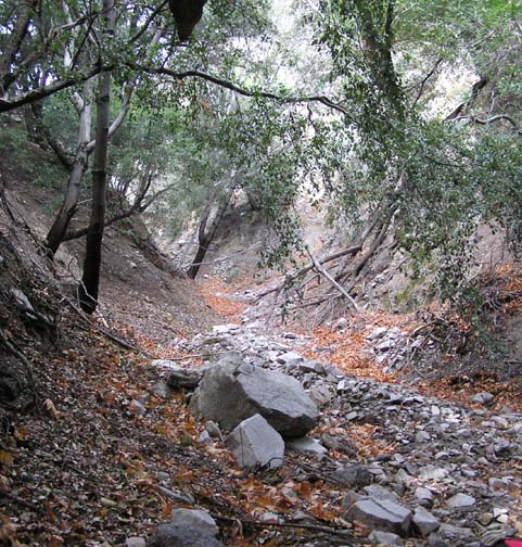
| Lower Sutton Canyon (Photo by Ken King) |
Turning right (east) at the junction hike down the Mount Lukens Road for about 0.9mi to where the road contours around the head of Sutton Canyon. There are several drop-in routes near the head at about 34o15.45'N 118o13.06'W; one route is to descend the small steep ridge about 100yds west of the canyon head since it has some clear patches in the brush. Descend about 100ft down the ridge and then, just before a small saddle, veer left following animal trails into the gully bottom. You should reach the gully bottom at 4050ft about 3hrs 20min after the morning start.
 | 
| |
|---|---|---|
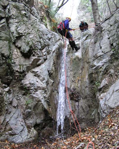
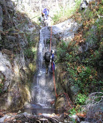
| Rappel at 2790ft (Photo by Ken King) | The third step in the staircase (Photo by Ken King) |
Fortunately the canyon from here on is relatively brush-free though the upper reaches have some loose and sandy downclimbs. At 3810ft there is a very loose and awkward drop that most will choose to rappel for about 20ft from a tree anchor on the right. Just a short distance downstream you will encounter another steep downclimb at 3690ft just before a major junction where at least two other gullies come in on the left. Another brief hike brings you, at 3530ft, to a 20ft drop with an exposed bypass on the right that is better rappeled from a tree anchor on the left. You should reach this rappel about 4hrs from the start. Here Sutton begins to become more woody and shaded; a large canyon comes in on the left at 3410ft, another comes in from the right at 3140ft and yet another enters on the left at 3020ft. Shortly thereafter you encounter the first signs of human presence, an old rusty waterpipe high on the right side of the canyon. You should encounter the pipe at 2980ft about 4hrs 50min from the start.
The canyon continues to be easy going though there is one small 20ft rappel at 2790ft for which there is a tree anchor at the lip. Then, finally, at 2530ft and 5hrs 50min from the start, you will arrive at the top of the Sutton Staircase, a series of steps that represent the main action in Sutton Canyon. The first step consists of an old man-made 15ft stone dam strangely placed at the top of a series of natural drops. This first step is easily bypassed on the left and leads to the second step, a natural drop of about 20ft that can be rappeled using a large tree on the left. Below this and just a short distance downstream is the third and largest step, a 25ft natural, vertical rappel that is best anchored from a tree on the left a little way back from the lip. Water normally flows in all these lower falls but the pools at the base are usually no more than shin-deep. The fourth step is a 15ft two-step rappel from a tree on the right and the small, fifth step is readily downclimbed using a profusion of tree roots on the left.
Below these five steps it is only a few hundred yards to the end of the canyon descent. As the canyon opens up, look for twin pipelines descending on one side of the canyon and climbing the other. Just beyond the pipelines, you will encounter a small flood-control dam. Look for a rough use-trail that climbs the canyon wall on the left just upstream of the dam; ascending this will bring you immediately to the trailhead at the top of Ocean View Boulevard and to your return vehicle(s).
You should reach this trailhead at
34o14.52'N 118o13.36'W and an elevation of
2450ft about 6.5hrs from the morning start having covered
about 5.3mi.
Last updated 1/28/07.
Christopher E. Brennen